Skip to main content Accessibility help
×
Hostname: page-component-848d4c4894-x5gtn Total loading time: 0 Render date: 2024-05-01T03:01:24.042Z Has data issue: false hasContentIssue false

Reference

Published online by Cambridge University Press:  23 January 2010

John B. Adams
Affiliation:
University of Washington
Alan R. Gillespie
Affiliation:
University of Washington
Get access

Summary

Image of the first page of this content. For PDF version, please use the ‘Save PDF’ preceeding this image.'
Type
Chapter
Information
Remote Sensing of Landscapes with Spectral Images
A Physical Modeling Approach
, pp. 350 - 356
Publisher: Cambridge University Press
Print publication year: 2006

Access options

Get access to the full version of this content by using one of the access options below. (Log in options will check for institutional or personal access. Content may require purchase if you do not have access.)

References

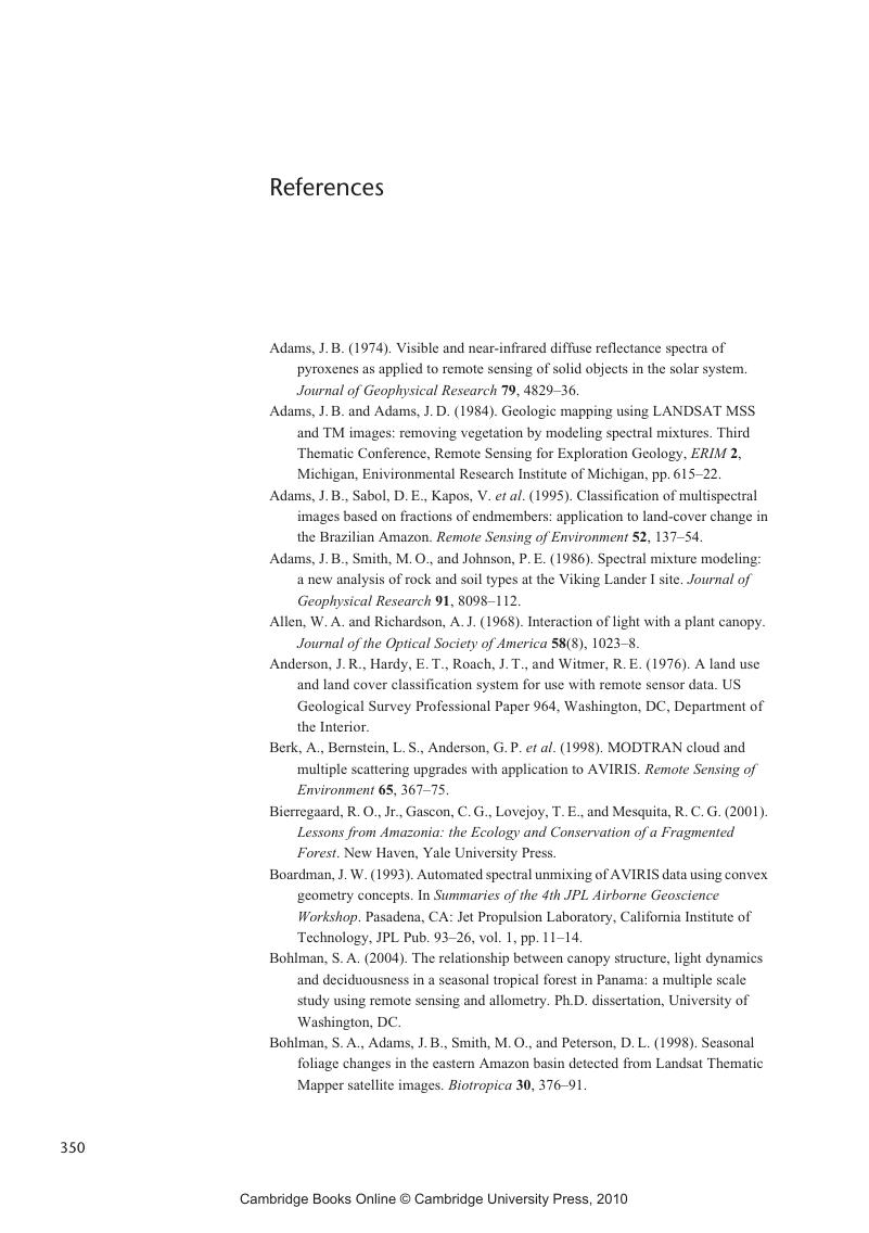
Adams, J. B. (1974). Visible and near-infrared diffuse reflectance spectra of pyroxenes as applied to remote sensing of solid objects in the solar system. Journal of Geophysical Research 79, 4829–36.CrossRefGoogle Scholar
Adams, J. B. and Adams, J. D. (1984). Geologic mapping using LANDSAT MSS and TM images: removing vegetation by modeling spectral mixtures. Third Thematic Conference, Remote Sensing for Exploration Geology, ERIM 2, Michigan, Enivironmental Research Institute of Michigan, pp. 615–22.Google Scholar
Adams, J. B., Sabol, D. E., Kapos, V.et al. (1995). Classification of multispectral images based on fractions of endmembers: application to land-cover change in the Brazilian Amazon. Remote Sensing of Environment 52, 137–54.CrossRefGoogle Scholar
Adams, J. B., Smith, M. O., and Johnson, P. E. (1986). Spectral mixture modeling: a new analysis of rock and soil types at the Viking Lander I site. Journal of Geophysical Research 91, 8098–112.CrossRefGoogle Scholar
Allen, W. A. and Richardson, A. J. (1968). Interaction of light with a plant canopy. Journal of the Optical Society of America 58(8), 1023–8.CrossRefGoogle Scholar
Anderson, J. R., Hardy, E. T., Roach, J. T., and Witmer, R. E. (1976). A land use and land cover classification system for use with remote sensor data. US Geological Survey Professional Paper 964, Washington, DC, Department of the Interior.
Berk, A., Bernstein, L. S., Anderson, G. P.et al. (1998). MODTRAN cloud and multiple scattering upgrades with application to AVIRIS. Remote Sensing of Environment 65, 367–75.CrossRefGoogle Scholar
Bierregaard, R. O. Jr., Gascon, C. G., Lovejoy, T. E., and Mesquita, R. C. G. (2001). Lessons from Amazonia: the Ecology and Conservation of a Fragmented Forest. New Haven, Yale University Press.
Boardman, J. W. (1993). Automated spectral unmixing of AVIRIS data using convex geometry concepts. In Summaries of the 4th JPL Airborne Geoscience Workshop. Pasadena, CA: Jet Propulsion Laboratory, California Institute of Technology, JPL Pub. 93–26, vol. 1, pp. 11–14.Google Scholar
Bohlman, S. A. (2004). The relationship between canopy structure, light dynamics and deciduousness in a seasonal tropical forest in Panama: a multiple scale study using remote sensing and allometry. Ph.D. dissertation, University of Washington, DC.
Bohlman, S. A., Adams, J. B., Smith, M. O., and Peterson, D. L. (1998). Seasonal foliage changes in the eastern Amazon basin detected from Landsat Thematic Mapper satellite images. Biotropica 30, 376–91.CrossRefGoogle Scholar
Burns, R. G. (1970). Mineralogical Applications of Crystal Field Theory. Cambridge, Cambridge University Press.Google Scholar
Chrisman, N. R. (1997). Exploring Geographic Information Systems. New York, John Wiley & Sons.Google Scholar
Clark, R. N. (1999). Spectroscopy of rocks and minerals and principles of spectroscopy. In Remote Sensing for the Earth Sciences: Manual of Remote Sensing, 3rd edn., ed. Rencz, A. N.. New York, John Wiley & Sons, vol. 3, pp. 3–58.Google Scholar
Clark, R. N. and Roush, T. L. (1984). Reflectance spectroscopy: quantitative analysis techniques for remote sensing applications. Journal of Geophysical Research 89, 6329–40.CrossRefGoogle Scholar
Clark, R. N., Swayze, G. A., Livo, K. E.et al. (2003). Imaging spectroscopy: Earth and planetary remote sensing with the USGS Tetracorder and expert systems. Journal of Geophysical Research 108(E12), 5131. http://speclab.cr.usgs.gov/PAPERS/tetracorder.CrossRefGoogle Scholar
Conel, J. E. (1990). Determination of surface reflectance and estimates of atmospheric optical depth and single scattering albedo from Landsat Thematic Mapper data. International Journal of Remote Sensing 11(5), 783–828.CrossRefGoogle Scholar
Crist, E. P. and Cicone, R. C. (1984). Comparisons of the dimensionality and features of simulated Landsat-4 MSS and TM data. Remote Sensing of Environment 14, 235–46.CrossRefGoogle Scholar
Crist, E. P. and Kauth, R. J. (1986). The tasseled cap de-mystified. Photogrammetric Engineering and Remote Sensing 52(1), 81–6.Google Scholar
Crist, E. P., Laurin, R., and Cicone, R. C. (1986). Vegetation and soils information contained in transformed Thematic Mapper data. In IGARSS '86, Zurich, ESA Publications Division, vol. ESA SP-254, pp. 1465–72.
Curtiss, B., Adams, J. B., and Ghiorso, M. (1985). Origin, development and chemistry of silica–alumina rock coatings from the semi-arid regions of the island of Hawaii. Geochimica et Cosmochimica Acta 40, 49–56.CrossRefGoogle Scholar
Ehrlich, P. R. and Ehrlich, A. H. (2004). One With Nineveh. Washington, Island Press.Google Scholar
Elvidge, C. D. (1989). Vegetation reflectance features in AVIRIS data. Proceedings of the sixth Thematic Conference on Remote Sensing for Exploration Geology, Houston, Texas, May 16–19.
Farr, T. and Adams, J. B. (1984). Rock coatings in Hawaii. Geological Society of America Bulletin 95, 1077–83.2.0.CO;2>CrossRefGoogle Scholar
Gillespie, A. R. (1992). Spectral mixture analysis of multispectral thermal infrared images. Remote Sensing of Environment 42(2), 137–145.CrossRefGoogle Scholar
Gillespie, A. R., Adams, J. B., Smith, M. O.et al. (1995). Forest mapping potential of ASTER. Journal of Remote Sensing Society, Japan 15(1), 62–71.Google Scholar
Gillespie, A. R., Kahle, A. B., and Palluconi, F. D. (1984). Mapping alluvial fans in Death Valley, California, using multichannel thermal infrared images. Geophysical Research Letters 11, 1153–6.CrossRefGoogle Scholar
Gillespie, A. R., Kahle, A. B., and Walker, R. E. (1986). Color enhancement of highly correlated images, I. Decorrelation and HSI contrast stretches. Remote Sensing of Environment 20, 209–35.CrossRefGoogle Scholar
Goetz, A. F. H. and Billingsley, F. C. (1973). Digital image enhancement techniques used in some ERTS application problems. In Third Earth Resources Technology Satellite-1 Symposium. Washington, DC, National Aeronautics and Space Administration, NASA SP-351, pp. 1911–93.
Goetz, A. F. H., Vane, G., Solomon, J. E. and Rock, B. N. (1985). Imaging spectrometry for Earth remote sensing. Science 228(4704), 1147–53.CrossRefGoogle ScholarPubMed
Greenberg, J. D. (2000). Analysis of urban–rural gradients using satellite data. Ph.D. dissertation, University of Washington, Seattle, WA.
Gu, D. and Gillespie, A. (1998). Topographic normalization of LANDSAT TM images of forests based on subpixel sun-canopy-sensor geometry. Remote Sensing of Environment 64, 166–75.CrossRefGoogle Scholar
Gu, D., Gillespie, A. R., Adams, J. B., and Weeks, R. (1999). A statistical approach for topographic correction of satellite images using spatial context information. IEEE Transactions on Geoscience and Remote Sensing, 37(1), 236–46.Google Scholar
Hall, F. G., Knapp, D. E., and Huemmrich, K. F. (1997). Physically based classification and satellite mapping of biophysical characteristics in the southern boreal forest. Journal of Geophysical Research, 102(D24), 29567–80.CrossRefGoogle Scholar
Hall, F. G., Strebel, D. E., Nickeson, J. E., and Goetz, S. J. (1991). Radiometric rectification: toward a common radiometric response among multidate, multisensor images. Remote Sensing of Environment 35, 11–27.CrossRefGoogle Scholar
Hapke, B. (1967). A readily available material for the simulation of lunar optical properties. Icarus 6, 277–8.CrossRefGoogle Scholar
Hapke, B. (1993). Theory of Reflectance and Emittance Spectroscopy. Cambridge, Cambridge University Press.CrossRefGoogle Scholar
Harsanyi, J. C. and Chang, C. I. (1994). Detection of low-probability subpixel targets in hyperspectral image sequences with unknown backgrounds. IEEE Transactions on Geoscience and Remote Sensing 32, 779–85.CrossRefGoogle Scholar
Head, J. W., Pieters, C., McCord, T. B., Adams, J. B., and Zisk, S. (1978). Definition and detailed characterization of lunar surface units using remote observations. Icarus 33, 145–72.CrossRefGoogle Scholar
Holben, B. N., Schutt, J. B., and McMurtrey, J. III (1983). Leaf water stress detection utilizing Thematic Mapper bands 3, 4 and 5 in soybean plants. International Journal of Remote Sensing 4, 289–97.CrossRefGoogle Scholar
Hook, S. J., Abbott, E. A., Grove, C., Kahle, A. B., and Palluconi, F. (1999). Use of multispectral thermal infrared data in geological studies. In Remote Sensing for the Earth Sciences: Manual of Remote Sensing, 3rd edn., ed. Rencz, A. N.. New York, John Wiley & Sons, vol. 3, pp. 59–103.Google Scholar
Huete, A., Justice, C., and Liu, H. (1994). Development of vegetation and soil indices for MODIS-EOS. Remote Sensing of Environment 49, 224–34.CrossRefGoogle Scholar
Huete, A. R., Liu, H. Q., Batchily, K., and Leeuwen, W. (1997). Comparison of vegetation indices over a global set of TM images for EOS-MODIS. Remote Sensing of Environment 59, 440–51.CrossRefGoogle Scholar
Jensen, J. R. (1996). Introductory Digital Image Processing: a Remote Sensing Perspective, 2nd. edn. Upper Saddle River, NJ, Prentice Hall.Google Scholar
Kahle, A. B., Gillespie, A. R., Abbott, E. A.et al. (1988). Relative dating of Hawaiian lava flows using multispectral thermal infrared images: a new tool for geologic mapping of young volcanic terranes. Journal of Geophysical Research 93, 15239–51.CrossRefGoogle Scholar
Kapos, V., Wandelli, E., Camargo, J. L., and Ganade, G. 1997. Edge-related changes in environment and plant responses due to forest fragmentation in central Amazonia. In Tropical Forest Remnants: Ecology, Management, and Conservation of Fragmented Communities, eds. Lawrence, W. F. and Bierregaard, R. O. Jr. Chicago, University of Chicago Press, pp. 33–44.Google Scholar
Kauth, R. J. and Thomas, G. S. (1976). The tasseled cap – a graphic description of the spectral-temporal development of agricultural crops as seen by LANDSAT. Symposium Proceedings, Machine Processing of Remotely Sensed Data. Purdue University, IN, pp. 41–51.
Kruse, F. A. (1999). Visible and infrared: sensors and case studies. In Remote Sensing for the Earth Sciences: Manual of Remote Sensing, 3rd edn., ed. Rencz, A. N.. New York, John Wiley & Sons, vol. 3, pp. 67–611.Google Scholar
Li, X., Strahler, A. H., and Woodcock, C. E. (1995). A hybrid geometric optical radiative transfer approach for modeling albedo and directional reflectance of discontinuous canopies. IEEE Transactions on Geoscience and Remote Sensing 33, 466–80.Google Scholar
Linthicum, K. J., Anyamba, A., Tucker, C. J. (1999). Climate and satellite indicators to forecast Rift Valley fever epidemics in Kenya. Science 285(5426), 397–400.CrossRefGoogle ScholarPubMed
Logsdon, M. G., Kapos, V., and Adams, J. B. (2001). Characterizing the changing spatial structure of the landscape. In Lessons from Amazonia: the Ecology and Conservation of a Fragmented Forest, ed. Bierregaard, R. Jr., Gascon, C. G., Lovejoy, T. E. and Mesquita, R. C. G.. New Haven, Yale University Press, pp. 358–68.Google Scholar
Lucas, R. M., Honzak, M., Foody, G. M., Curran, P. J., and Corves, C. (1993). Characterizing tropical secondary forests using multi-temporal Landsat sensor imagery. International Journal of Remote Sensing 14, 3016–67.CrossRefGoogle Scholar
Lucas, R. M., Honzak, M., Amaral, I., Curran, P. J., and Foody, G. M. (2002). Forest regeneration on abandoned clearances in central Amazonia. International Journal of Remote Sensing 23(5), 965–88.CrossRefGoogle Scholar
Mandelbrot, B. B. (1967). How long is the coast of Britain? Statistical self-similarity and fractional dimension. Science 156, 636–8.CrossRefGoogle Scholar
Mazer, A. S., Martin, M., Lee, M., and Solomon, J. E. (1988). Image-processing software for imaging spectrometry data analysis. Remote Sensing of Environment, 24(1), 201–10.CrossRefGoogle Scholar
McCord, T. B., Charette, M., Johnson, T. V.et al. (1972). Lunar spectral types. Journal of Geophysical Research 77, 1349–59.CrossRefGoogle Scholar
McCord, T. B., Pieters, C., and Feierberg, M. A. (1976). Multispectral mapping of the lunar surface using ground-based telescopes. Icarus 29, 1–34.CrossRefGoogle Scholar
Mushkin, A. and Gillespie, A. R. (in press). Estimating sub-pixel surface roughness using remotely sensed stereoscopic data. Remote Sensing of Environment.
Mustard, J. F., Li, L. and He, G.-Q. (1998). Nonlinear spectral mixture modeling of lunar multispectral data: implications for lateral transport. Journal of Geophysical Research, 103(E8), 19419–25.CrossRefGoogle Scholar
Mustard, J. F. and Sunshine, J. M. (1999). Spectral analysis for Earth science: investigations using remote sensing data. In Remote Sensing for the Earth Sciences: Manual of Remote Sensing, 3rd edn., ed. Rencz, A. N.. New York, John Wiley & Sons, vol. 3, pp. 251–306.Google Scholar
Neukum, G., Jaumann, R., and the HRSC Co-Investigator and Experiment Team (2004). HRSC – the high resolution stereo camera of Mars Express. European Space Agency SP-1240, pp. 17–35.
Pech, R. P., Graetz, R. D., and Davis, A. W. (1986). Reflectance modeling and the derivation of vegetation indices for an Australian semi-arid shrubland. International Journal of Remote Sensing 7(3), 389–403.CrossRefGoogle Scholar
Pieters, C. M. (1993). Compositional diversity and stratigraphy of the lunar crust derived from reflectance spectroscopy. In Remote Geochemical Analysis: Elemental and Mineralogical Composition, eds. Pieters, C. M. and Englert, P. A. J.. Cambridge, Cambridge University Press, pp. 594.Google Scholar
Richardson, A. J. and Wiegand, C. L. (1977). Distinguishing vegetation from soil background information. Photogrammetric Engineering and Remote Sensing 43, 1541–52.Google Scholar
Ridd, M. K. (1995). Exploring a V–I–S (vegetation–impervious surface–soil) model for urban ecosystem analysis through remote sensing: comparative anatomy for cities. International Journal of Remote Sensing 16(12), 2165–85.CrossRefGoogle Scholar
Roberts, D. A., Adams, J. B., and Smith, M. O. (1990). Predicted distribution of visible and near-infrared radiant flux above and below a transmittant leaf. Remote Sensing of Environment 34(1), 1–17.CrossRefGoogle Scholar
Roberts, D. A., Batista, G., Pereira, J., Waller, E., and Nelson, B. (1998b). Change identification using multitemporal spectral mixture analysis: applications in eastern Amazonia. In Remote Sensing Change Detection: Environmental Monitoring Applications and Methods, eds. Elvidge, C. and Lunetta, R.. Ann Arbor, MI, Ann Arbor Press, pp. 137–61.Google Scholar
Roberts, D. A., Gardner, M., Church, R.et al. (1998c). Mapping chaparral in the Santa Monica Mountains using multiple endmember spectral mixture models. Remote Sensing of Environment 65(3), 267–79.CrossRefGoogle Scholar
Roberts, D. A., Nelson, B. W., Adams, J. B., and Palmer, F. (1998a). Spectral changes with leaf aging in Amazon caatinga. Trees 12, 315–25.CrossRefGoogle Scholar
Roberts, D. A., Ustin, S. L., Ogunjemiyo, S.et al. (2004). Spectral and structural measures of northwest forest vegetation at leaf to landscape scales. Ecosystems 7(5), 545–62.CrossRefGoogle Scholar
Rosema, A., Verhoef, W., Noorbergen, H., and Borgesius, J. J. (1992). A new forest light interaction model in support of forest monitoring. Remote Sensing of Environment 42(1), 23–41.CrossRefGoogle Scholar
Rouse, J. W., Haas, R. H., Schell, J. A., and Deering, D. W. (1973). Monitoring vegetation systems in the great plains with ERTS. In Third Earth Resources Technology Satellite-1 Symposium. Washington, DC, National Aeronautics and Space Administration, NASA SP-351, pp. 309–17.
Rowan, L. C., Simpson, C. J., and Mars, J. C. (2004). Hyperspectral analysis of the ultramafic complex and adjacent lithologies at Mordor, NT, Australia. Remote Sensing of Environment 91(3–4), 419–31.CrossRefGoogle Scholar
Sabins, F. F. (1996). Remote Sensing: Principles and Interpretation, 3rd edn. New York, Freeman.Google Scholar
Sabol, D. E., Adams, J. B., and Smith, M. O. (1992). Quantitative sub-pixel detection of targets in multispectral images. Journal of Geophysical Research, 97(E2), 2659–72.CrossRefGoogle Scholar
Sabol, D. E. Jr., Gillespie, A. R., Adams, J. B., Smith, M. O., Tucker, C. J. (2002). Structural stage in Pacific northwest forests estimated using simple mixing models of multispectral images. Remote Sensing of Environment, 80(1), 1–16.CrossRefGoogle Scholar
Salisbury, J. W., Walter, L. S., Vergo, N., and D'Aria, D. M. (1991). Infrared (2.1–25 µm) Spectra of Minerals. Baltimore, Johns Hopkins University Press.Google Scholar
Schott, J. R. (1997). Remote Sensing: the Image Chain Approach. New York, Oxford University Press.Google Scholar
Schowengerdt, R. A. (1997). Remote Sensing: Models and Methods for Image Processing, 2nd edn. San Diego, CA, Academic Press.Google Scholar
Shipman, H. and Adams, J. B. (1987). Detectability of minerals on desert alluvial fans using reflectance spectra. Journal of Geophysical Research 92, 10391–402.CrossRefGoogle Scholar
Smith, M. O., Adams, J. B., and Sabol, D. E. (1994a). Spectral mixture analysis – new strategies for the analysis of multispectral data. In Imaging Spectrometry – a Tool for Environmental Observations, eds. Hill, J. and Megier, J.. Dordrecht, Kluwer Academic, pp. 125–43.CrossRefGoogle Scholar
Smith, M. O., Adams, J. B., and Sabol, D. E. (1994b). Mapping sparse vegetation canopies. In Imaging Spectrometry – a Tool for Environmental Observations, eds. Hill, J. and Megier, J.. Dordrecht, Kluwer Academic, pp. 221–35.CrossRefGoogle Scholar
Smith, M. O., Ustin, S. L., Adams, J. B., and Gillespie, A. R. (1990a). Vegetation in deserts: I. A regional measure of abundance from multispectral images. Remote Sensing of Environment 31, 1–26.CrossRefGoogle Scholar
Smith, M. O., Ustin, S. L., Adams, J. B., and Gillespie, A. R. (1990b). Vegetation in deserts: II. Environmental influences on regional abundance. Remote Sensing of Environment 31, 27–52.CrossRefGoogle Scholar
Strahler, A. H. (1994). Vegetation canopy reflectance modeling: recent developments and remote sensing perspectives. Remote Sensing Reviews 15, 159–94.Google Scholar
Suits, G. H. (1972). The calculation of the directional reflectance of a vegetative canopy. Remote Sensing of Environment 2, 117–25.CrossRefGoogle Scholar
Sunshine, J. M., Pieters, C. M., and Pratt, S. F. (1990). Deconvolution of mineral absorption bands: an improved approach. Journal of Geophysical Research 95, 6955–66.CrossRefGoogle Scholar
Tanner, E. V. J., Kapos, V., and Adams, J., 1998. Tropical forests – spatial pattern and change with time, as assessed by remote sensing. In Dynamics of Tropical Communities, eds. Newbery, D. M., Prins, H. H. T., and Brown, N. D. (37th Symposium of the British Ecological Society). London, Blackwell Science, pp. 599–615.Google Scholar
Tompkins, S., Mustard, J. F., Pieters, C. M., and Forsyth, D. W. (1997). Optimization of endmembers for spectral mixture analysis. Remote Sensing of Environment 59(3), 472–89.CrossRefGoogle Scholar
Tucker, C. J., Townshend, R. G., and Goff, T. E. (1985). African land cover classification using satellite data. Science 227(4685), 369–75.CrossRefGoogle ScholarPubMed
Ustin, S. L., Smith, M. O., Jacquemoud, S., Verstraete, M., and Govaerts, Y. (1999). Geobotany: vegetation mapping in Earth sciences. In Remote Sensing for the Earth Sciences, Manual of Remote Sensing, 3rd edn., ed. Rencz, A. N.. New York, John Wiley & Sons, vol. 3, pp. 189–248.Google Scholar
Verhoef, W. (1984). Light scattering by leaf layers with application to canopy reflectance modeling: the SAIL model. Remote Sensing of Environment 16(2), 125–41.CrossRefGoogle Scholar
Weeks, R. J., Smith, M. O., Pak, K.et al. (1996). Surface roughness, radar backscatter, and visible and near-infrared reflectance in Death Valley, California. Journal of Geophysical Research 101, 23077–90.CrossRefGoogle Scholar
Wu, C. and Murray, A. T. (2003). Estimating impervious surface distribution by spectral mixture analysis. Remote Sensing of Environment 84(4), 493–505.CrossRefGoogle Scholar

Save book to Kindle

To save this book to your Kindle, first ensure coreplatform@cambridge.org is added to your Approved Personal Document E-mail List under your Personal Document Settings on the Manage Your Content and Devices page of your Amazon account. Then enter the ‘name’ part of your Kindle email address below. Find out more about saving to your Kindle.

Note you can select to save to either the @free.kindle.com or @kindle.com variations. ‘@free.kindle.com’ emails are free but can only be saved to your device when it is connected to wi-fi. ‘@kindle.com’ emails can be delivered even when you are not connected to wi-fi, but note that service fees apply.

Find out more about the Kindle Personal Document Service.

  • Reference
  • John B. Adams, University of Washington, Alan R. Gillespie, University of Washington
  • Book: Remote Sensing of Landscapes with Spectral Images
  • Online publication: 23 January 2010
  • Chapter DOI: https://doi.org/10.1017/CBO9780511617195.012
Available formats
×

Save book to Dropbox

To save content items to your account, please confirm that you agree to abide by our usage policies. If this is the first time you use this feature, you will be asked to authorise Cambridge Core to connect with your account. Find out more about saving content to Dropbox.

  • Reference
  • John B. Adams, University of Washington, Alan R. Gillespie, University of Washington
  • Book: Remote Sensing of Landscapes with Spectral Images
  • Online publication: 23 January 2010
  • Chapter DOI: https://doi.org/10.1017/CBO9780511617195.012
Available formats
×

Save book to Google Drive

To save content items to your account, please confirm that you agree to abide by our usage policies. If this is the first time you use this feature, you will be asked to authorise Cambridge Core to connect with your account. Find out more about saving content to Google Drive.

  • Reference
  • John B. Adams, University of Washington, Alan R. Gillespie, University of Washington
  • Book: Remote Sensing of Landscapes with Spectral Images
  • Online publication: 23 January 2010
  • Chapter DOI: https://doi.org/10.1017/CBO9780511617195.012
Available formats
×