
In the course of an investigation into the probable location and extent of the territory inhabited by the Arosæte, and into their relations with their much larger neighbours the Hwicce, a tentative conclusion was reached which, if accepted, would have major implications for our understanding of the history of Mercian rule in midland England.Footnote 1 The Arosæte are known to us solely from their inclusion in the Tribal Hidage, a probable late seventh- or eighth-century Mercian tribute list.Footnote 2 It assigns to them an assessment of 600 hides, while the Hwicce (of whom they appear still to have been independent at the time of compilation of the list’s original elements), were assessed at 7000 hides.Footnote 3 By the end of the eighth century the Arosæte, whose territory seems to have been centred on Alcester (Warwicks.),Footnote 4 had been absorbed into the kingdom of the Hwicce and the coterminous diocese of Worcester. It is very likely, then, that as a result of this amalgamation of the two peoples the Hwicce were thereafter assessed at 7600 hides.
This, however, greatly exceeds the sum of the assessments recorded by Domesday Book for all land in the late eleventh-century diocese of Worcester (which arguably represents the area of the former kingdom of the Hwicce at its greatest extent). The total for 1086 has been calculated by the author as 3875¼ hides, which is the sum of the hidages of the following four areas (Fig. 1): (1) the putative former territory of the Arosæte, which appears to be effectively mirrored by the interlocking Domesday hundreds of Ferncombe and Pathlow (236¼ hides);Footnote 5 (2) the rest of the part of Warwickshire situated within the medieval diocese of Worcester (337½ hides); (3) Worcestershire, minus the parts of Doddingtree Hundred which were in the medieval diocese of Hereford (1121½ hides);Footnote 6 and (4) Gloucestershire, east of the River Severn (2180 hides).Footnote 7 It is the case that the total recorded assessment in 1086 of all land in the former kingdom of the Hwicce (3875¼ hides) amounts to almost exactly fifty-one per cent of the total of 7600 hides at which the area is arguably assessed in the Tribal Hidage. Calculating the Domesday hidage of any large area, such as a medieval shire or, as here, a diocese, is often fraught with unresolvable difficulties, and so this degree of reduction between the earlier and later totals can not be considered an exact one. Nevertheless, even if every quibble raised about how the calculation of the Domesday total was to lead to such and such a change being made, the resultant outcome would be sure to remain near enough to a halving for such an estimate to be taken as a reasonable working hypothesis.
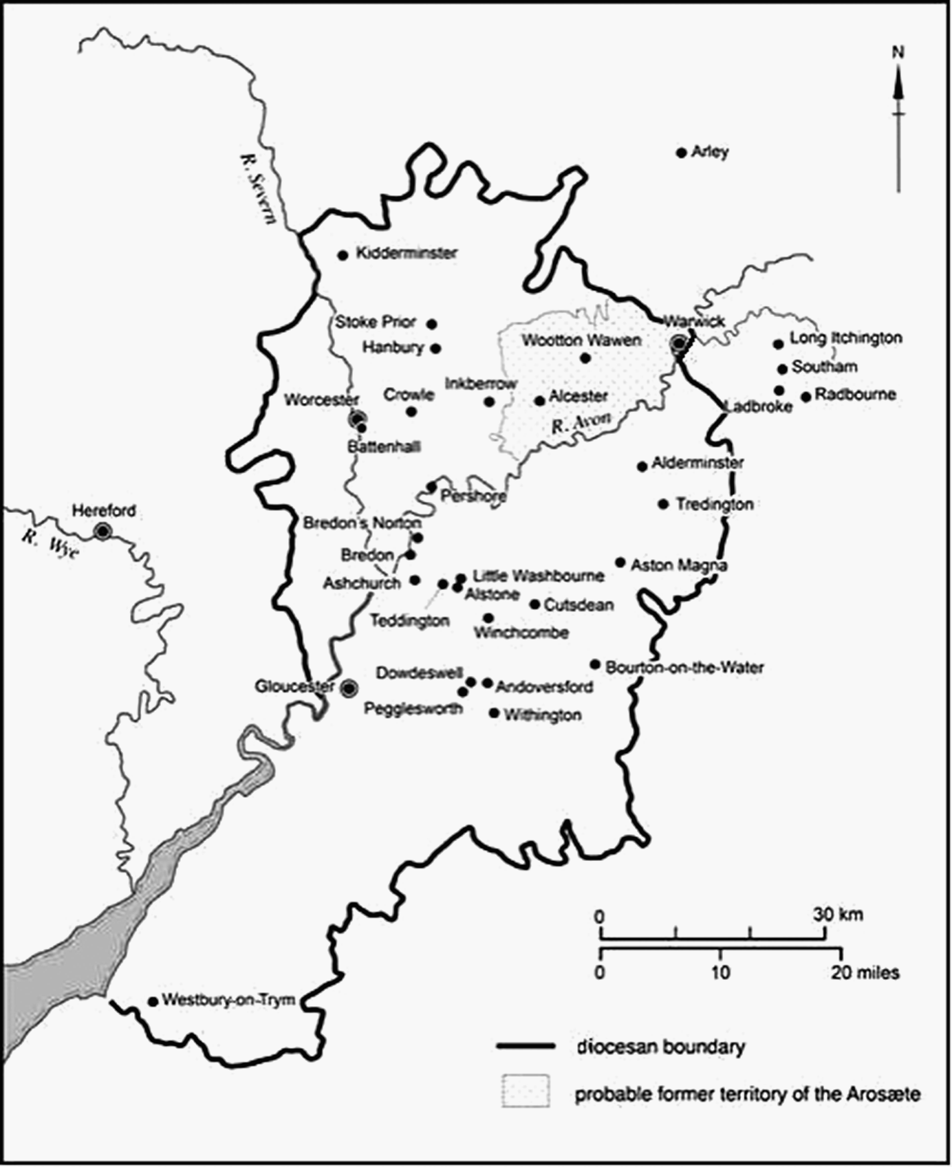
Figure 1: The diocese of Worcester at its estimated extent in the eighth century, when it was arguably coterminous with the kingdom of the Hwicce. The putative area of the formerly independent polity associated with the Arosæte is also shown. Named places are those referred to in the article. Map by author.
The fact of a very substantial reduction is, then, undeniable; but when and why it was made, and by whom, are questions which will prove very difficult, if not impossible, to answer convincingly. The one way of proceeding which offers a chance of at least partial success is to study the assessments recorded in grants of land of the intervening period. There is little point in looking at those given in the texts of grants and leases which are known to us only from later copies, no matter how good any copy’s reputation is in general terms. Once the assessment of a given area of land had been reduced, it would have been in its ecclesiastical possessor’s urgent interest to ensure that its written title to it specified the new hidage, given that this figure was the basis on which the amount of future renders would have to be paid.Footnote 8 In Worcester’s case, therefore, we must assume that the contents of all three of its cartularies give revised assessments, not the original ones. If this is indeed so, the assessment of the land granted in 716 × 737 to the minster at Wootton Wawen, for example, would originally have been in the region of forty hides, not twenty as reported in Worcester’s early eleventh-century cartulary.Footnote 9
Accordingly, to stand any chance of identifying unrevised assessments, and thus of ascertaining if they are likely to have been substantially revised downwards in due course, we must look at the few surviving original charters for land in the area of the kingdom of the Hwicce, or else as second best at those texts which are generally thought to be near-contemporary copies (Fig. 1).Footnote 10
This entire exercise is, however, fraught with difficulties. First, it is very likely that, in the form in which we have it, the Tribal Hidage is a compilation of at least two different periods,Footnote 11 so that there can be no certainty about the date by which the area associated with the Arosæte had been formed. The list begins with the Mercians, however, and much of its content appears to relate to the inhabitants (or, in some cases, the dominant ones) of areas which were geographically close to the core of the Mercian kingdom and therefore likely to have become subordinate to its kings at an early date.Footnote 12 This makes it reasonable to view the area associated with the Arosæte as one which existed, and was so called, by no later than the early eighth century. A second difficulty is that it is an essential premise of the present study that the Tribal Hidage was in origin an assessment list; but not everyone accepts that this is so.Footnote 13
A third one concerns the single-sheet manuscripts which form the evidential basis of this study. There can be no certainty that they all have an incontestable claim to be valid. Not knowing the circumstances (including exact date) of each one’s creation makes it impossible to rule out the possibility that some were fraudulently composed in support of a claim, whether legitimate or otherwise, to disputed land. The ongoing publication of the texts of charters in their archival context, under the auspices of the British Academy, is affording us the necessary expert opinion on such matters,Footnote 14 but few of those on which this present study depends are yet available in the series.
A fourth difficulty must also be mentioned – that of there usually being no way of knowing beyond doubt that a land unit recorded in Domesday Book (or a group of adjacent ones believed to have been formed by the fission of a larger one), had the same extent as an earlier, eponymous land unit granted by charter. This adds a further uncertainty to a comparison of the assessments borne by what is allegedly the same area at different periods.
Difficulties of these sorts necessitate a detailed and therefore often lengthy discussion of each charter or lease being considered. They also make it essential for readers to view what follows as a more than usually speculative exercise. This article’s hypothesis is being offered, warts and all, in order to stimulate discussion. As ever, individuals must decide for themselves whether or not to go along with its inevitable leaps of faith and assumptions, and whether to accept or reject its tentatively presented conclusions. It is to be hoped that any debate which may ensue will further our understanding of the relations between early kingdoms and lesser polities and, secondly, of the role of assessments in Anglo-Saxon statecraft.
ASSESSMENTS GIVEN IN SINGLE-SHEET MANUSCRIPTS
Unfortunately, of the dozen or so such texts which date to before 1000 most are unusable for this purpose for one reason or another, as will now be shown.
STURE IN ISMERE
S 89, the earliest of these texts, records the grant in 736 of ten hides (cassati) of land in the territory named Husmeræ and another four hides at Brochyl. They were to be used for a minster’s foundation, probably at Kidderminster (Worcs.).Footnote 15 The land’s extent is unknown, however;Footnote 16 and even though four other charters refer to this land, none includes a statement of its bounds.Footnote 17 It is impossible to identify the land in the late eleventh-century landscape, therefore,Footnote 18 and as a result to compare its assessment in and after 736 with what is recorded in Domesday Book for the same area.
ASTON IN STOKE PRIOR
Three versions exist of the text of a grant made in, it seems, 767 of five hides of land at Aston, which the boundary clause shows to have been in the parish of Stoke Prior (Worcs.).Footnote 19 S 59 (dated 770), a single-sheet manuscript in a late eighth- or early ninth-century hand, was convincingly argued by Patrick Wormald to be a very early forgery.Footnote 20 The second version, S 58 (dated 767), is known only from two seventeenth-century copies,Footnote 21 which both give the assessment – as does S 59 – as five hides. The copies are considered authentic; but in the absence of S 58’s original manuscript it is impossible to know if this is the assessment which it always recorded or if, instead, it represents an emendation. Finally, S 60, dated 770 (which is known only in a late eleventh-century copy, which is based on S 59, and which grants all of Stoke Prior as a ten-hide estate), is universally seen as being spurious.Footnote 22 Accordingly, we can not be sure what Aston’s assessment actually was in the late eighth century. It may indeed have been five hides, arguably halving to two and a half hides at a later date; but in any case there is no way of our determining what assessment it carried when simply named as one of Stoke Prior’s berewicks in 1086.Footnote 23 (Nor, of course, do we know the eighth-century assessment of the area of the Domesday manor of Stoke Prior, since S 60 must be assumed to reflect its late eleventh-century one.)
SALMONSBURY
S 114, dated 779, is known only from a single-sheet manuscript in a late eighth-century hand. It records a grant of four hides of land at Salmonsbury and is reckoned to be an authentic original text.Footnote 24 A ninth- or tenth-century endorsement notes that this land was at Bourton [on-the-Water] (Gloucs.), a manor which was assessed at ten hides in 1086.Footnote 25 However, although the land’s probable extent is known from S 114’s boundary statement,Footnote 26 the late eighth-century assessment of the whole area of the Domesday manor of Bourton is not; nor, of course, is the proportion of the latter’s assessment which is represented by the area granted in 779.
WESTBURY-ON-TRYM
There are three versions of S 139, a grant of fifty-five hides of land at Westbury-on-Trym (Gloucs.) made in 793 × 796. One of them is a single-sheet manuscript, contemporaneous and probably original,Footnote 27 and the others are copies of the early eleventh century and the seventeenth respectively. In 1086 the extensive manor of Westbury was assessed at fifty hides;Footnote 28 but with no boundary statement having been included in the text it is impossible to know what portion of the area of the Domesday manor this booked land represented – whether only a part of it, that is, or its effective entirety.Footnote 29
CROWLE
This somewhat depressing survey continues with S 190, dated 836, which survives as a single-sheet manuscript in an early ninth-century hand, widely regarded as an original text,Footnote 30 and as three later, incomplete copies. It records a grant of privileges in respect of the lands of the minster at Hanbury (Worcs.). These include Crowle, assessed at ten hides. In 1086 there were two manors at Crowle, each assessed at five hides, one held by the Church of Worcester and the other held (as in 1066 too) by a layman.Footnote 31 This, then, may represent an instance of an assessment which was the same in 1086 as it had been in 836 – if, that is, the Hanbury minster held all of Crowle in 836, and if Worcester (which took over control of the minster’s lands)Footnote 32 had subsequently lost half as a result of an insufficiently well supervised leasing out of it. However, there is no mention of any such loss in Worcester sources, and so it is just as likely that Hanbury, and then Worcester, had held only one of the two Crowle estates, and that its assessment had been halved at an unknown date after 836. No resolution of this issue is possible.
ASTON MAGNA
S 1281, another text known only from a single-sheet manuscript, in an early tenth-century hand, is also regarded as an original. It records the leasing of one hide of land at Easttune, reliably identified as Aston Magna (Gloucs.), in 904,Footnote 33 and probably referred to again in a lease of 977 (S 1333). There is no entry for it in Domesday Book, however, and so nothing can be said about this assessment.Footnote 34
TEDDINGTON AND ALSTONE; CALDINCCOTAN IN BREDON
A lease for three lives of Teddington and Alstone (Worcs., now Gloucs.), dated 969, survives as a single-sheet original, but omits the hidage of the land concerned.Footnote 35 Similarly, another such original records the lease of two and a half hides at Caldinccotan in Bredon (Worcs.) in 984 (S 1347); but Domesday Book has no identifiable entry for the place, which by 1086 must have been part of the large episcopal manor of Bredon. In both instances, then, the absence of a key piece of information prevents any comparison being made of the hidages concerned.
INKBERROW
In 1010 × 1023 (probably 1023), a dispute was settled in respect of the tenure of part of a five-hide estate at Inkberrow (Worcs.), which belonged to Worcester but was currently – and, as it was adjudicated, correctly – in the bishop of Hereford’s hands. The evidence comes from a single-sheet manuscript (S 1460). This has been identified as Worcester’s portion of a three-part chirograph, and is widely seen as being contemporary and authentic.Footnote 36 In 1086 Worcester held a five-hide manor at Inkberrow, with the bishop of Hereford as sub-tenant.Footnote 37 It is very probable that these two records relate to the same estate. If so, the putative reduction in hidage had occurred by 1023.
PYRIAE IN ST MARTIN’S-WITHOUT-WORCESTER
Another lease, recorded in a single-sheet manuscript in an early eleventh-century hand (S 1385) and dated 1003 × 1016, confirms that the reduction had occurred by early in that century. It relates to a half hide of land at Pyriae in the parish of St Martin’s-without-Worcester, a name which survives as Perry Wood.Footnote 38 By use of the associated boundary statements this land has been decisively identified as half of a one-hide estate named Battenhall which had been leased by Bishop Oswald of Worcester for three lives in 969 (S 1327).Footnote 39 Domesday Book records that in 1086 Worcester had a one-hide manor at Pirian, but it contains no entry for Battenhall. Accordingly, S 1385 corroborates the evidence of S 1460 that the hidage reduction had been made by early in the eleventh century.
This does not mean, however, that it had only just occurred, since not one of the many earlier texts discussed above has allowed a clear-cut, reliable comparison to be made between the assessment of the piece of land concerned at the time of its pre-Conquest grant or lease and its hidage as recorded in 1086. The terminus ante quem for the reduction is capable, it seems, of being pushed earlier.
EVIDENCE OF AN ASSESSMENT REDUCTION PRIOR TO THE EARLY ELEVENTH CENTURY
In 972 King Edgar is alleged to have issued a general confirmation of its lands and privileges to the monastic community at Pershore (S 786). The authenticity of the single-sheet manuscript on which the earliest version of this grant is to be found continues to be debated, with opinion ranged between regarding it as an outright forgery and accepting that it is authentic and original; but it is almost unanimously regarded as being in a contemporary or near-contemporary hand.Footnote 40 Therefore, whether or not the confirmation is authentic, it is arguably safe to take the stated assessments as being those which the forty named areas of land bore in the late tenth century or, at latest, in the earliest part of the eleventh. A comparison of these assessments with ones given for the same places by Domesday Book produces the following results: six are not recorded there or else are named as the berewick of another manor with no separate hidage being given; seventeen unquestionably have the same assessment as S 786 assigns; another seven can be accepted as having the same assessment, once a case has been made;Footnote 41 and, finally, there is no match in ten instances.Footnote 42 This degree of correlation indicates that the hidage reduction had very probably been made by the late tenth century.
The information available for two areas of Gloucestershire, if found convincing, will limit the date range within which this reduction occurred to between the late eighth century and the late tenth or, arguably, the mid ninth.
DOWDESWELL
A single-sheet document, widely accepted as being original and genuine, records a grant of ten hides of land at Onnanforda in 759 (S 56).Footnote 43 It includes a very brief statement of the bounds of the area concerned, from which it appears that it comprised Upper Dowdeswell (which is the northern half of the ecclesiastical parish of Dowdeswell), including Andoversford (the text’s Onnanforda) and Pegglesworth.Footnote 44 The grantee was an abbot, Headda, who already had possession of Lower Dowdeswell. At an unknown date in the last two decades of the eighth century he granted his lands at Dowdeswell (including Andoversford) and at Tyreltune to his descendants, with reversion – or so the early eleventh-century copy of the text alleges – to the see of Worcester (S 1413).Footnote 45 By the late eleventh century Dowdeswell and Pegglesworth, together assessed at four and a half hides, were being held by Worcester as part of its manor of Withington.Footnote 46 Dowdeswell’s share of this assessment was later recorded as three hides and Pegglesworth’s as one and a half hides;Footnote 47 but the latter’s had also been three hides in 981, when Bishop Oswald issued an extension to a lease of it.Footnote 48 This shows that Worcester had lost about half of Pegglesworth by the late eleventh century. Accordingly, given that ten hides is the stated assessment of only a portion of Dowdeswell in 759, and that most of Dowdeswell (including Pegglesworth) was assessed at four and a half hides in 1086, with another one and a half hides at Pegglesworth having been lost since 981, it is clear that by 981 there had been a substantial reduction – arguably by at least fifty per cent – in the assessment of the land at Dowdeswell which Abbot Headda had held from 759 onwards.
CUTSDEAN
The final evidence to be presented here in support of the hypothesis that hidages of lands in the area of the kingdom of the Hwicce were substantially reduced, arguably by around a half, at an unknown date between the late eighth century and the late tenth – or perhaps (as will be seen) the mid ninth – concerns the Cotswold manor of Cutsdean (Gloucs. since 1931). In 1086 it was a detached piece of Worcestershire and the Church of Worcester’s triple hundred of Oswaldslow, assessed at two hides.Footnote 49 We have copies, apparently authentic, of two leases of Cutsdean, issued by Bishop Oswald: S 1335 (datable to c. 974) and S 1353 (987).Footnote 50 Each is accompanied by a boundary statement; these show separately that the area concerned coincides with the chapelry’s full extent.Footnote 51 In both instances the estate’s assessment is given as five hides.Footnote 52
By contrast, a grant to the minster community at Bredon (Worcs.), made in 780 by King Offa, of four estates (villulis) including Cutsdean gives the latter’s assessment as ten hides (S 116). Although only later copies survive, the charter’s text is considered authentic by most commentators.Footnote 53 The other three estates were at Teddington, Little Washbourne (both Worcs.), and Norðtun, which is widely and understandably identified as Bredon’s Norton (Worcs.).Footnote 54 The assessments recorded for them in Domesday Book were, like Cutsdean’s, lower: Teddington’s was said to be five hides in 780 but only three in 1086; Little Washbourne’s had gone down from ten hides to three, and Norðtun’s (if it was Bredon’s Norton) from ten hides to two.Footnote 55 Given that there is no other entry in Domesday Book for any of these places, and that a very considerable reduction in hidage assessments is known to have taken place between the late seventh century and (as has been shown here) the tenth century, it is likely that S 116 offers us instances of the original hidages of four estates, while, in most if not all cases, Domesday Book reports their reduced ones. An alternative hypothesis – that in every instance the difference between the two recorded assessments reflects the Church’s retention in demesne in 1086 of the ‘missing’ part of each manor – is less persuasive. If this argument is acceptable, S 116 shows that the hidage reduction had not yet been made in 780.
One final piece of evidence relating to Cutsdean might allow us to determine that it had been made by 855, but, as will be seen, such a conclusion depends on a degree of special pleading. Nonetheless the case is worth presenting. S 1273 is a Worcester lease of Cutsdean and Sture, which are said to be assessed together at eleven hides.Footnote 56 It is, of course, possible that only a single hide of land was being leased at Sture; but an alternative explanation is that the land being granted at Cutsdean had had its assessment reduced from ten to five hides since 780, and that the land at Sture was assessed at six hides. Various transactions involving Sture were made in the late eighth, ninth and tenth centuries. Even though none of them was of land assessed at six hides, in each case the land concerned had a different assessment.Footnote 57 This suggests that several parts of the extensive Sture district were being handed out, and that Worcester and Pershore were both accumulating land there in piecemeal fashion. It is a reasonable proposition that here we have evidence of an assessment having been reduced – by one-half in this case – by 855.
Two of the other transactions concerning land at Sture could conceivably limit the period within which the reduction was made to between 757 (but in reality 780, because of S 116) and 814, but every assumption needing to be made would have to be right for this to be the case. S 1829, known only from a seventeenth-century summary, is a reversionary grant of sixteen hides of land at Sture made to Worcester by Offa (datable only to his reign, 757 × 796), at the end of a lease for two lifetimes.Footnote 58 In 814 Coenwulf granted – or, arguably, confirmed – to Worcester eight hides of land at Sture, free from all but the three common burdens (S 171). He described it as a portion of his own land (aliquam partem terræ juris mei), which may allow its identification as the same land at Sture (or, if this argument fails, only half of it) as Offa had previously allowed Worcester to repossess. Here, then, we might be hearing about the same piece of land, first with its original assessment and then with its newly halved one. In this case it does not matter whether the land concerned was at Sture in Ismere or the medieval diocese’s other Sture, so long as it is the same one in both cases. What does matter, however, is that the copy of Coenwulf’s charter made in the early eleventh century (which is the only text we have), preserves the assessment given in the original manuscript – arguably left unaltered because the scribe was uncertain about the identity of the land concerned – rather than presenting us with an updated one, as we must assume to have been his and his colleagues’ normal practice.
DISCUSSION
On the basis of the albeit meagre evidence presented here it appears that the proposed reduction in the assessment of all land in the area of the kingdom of the Hwicce was not effected until late in the eighth century or thereafter, but that it had certainly been made by the late tenth century. Indeed, it had been by 855, if the land at Cutsdean of which Worcester issued a lease, together with some at Sture (S 1273), already had its new assessment of five hides. (The argument for pushing back the terminus ante quem to as early as 814, on the plainly uncertain evidence of S 1829 and S 171, although arguably worth presenting, is too flimsy to be more than merely noted in passing as a possibility.)
If it had been made by the middle part of the ninth century this reduction was almost certainly done by the Mercians. Even in the middle part of the eighth century the rulers of the Hwicce lacked the independence needed to effect such a major change, and by the end of it their former kingdom was under direct Mercian rule. By contrast, the Mercians themselves would have had both the power and, as will be shown in due course, the motive. If, however, this reduction was not made until the tenth century, for most of which period the area served by the see of Worcester was under the control of West Saxon kings, the latter would have to be seen as its perpetrators. The change would have been made as part of a process of reforming the existing territorial basis of local government so as to produce the layout of shires and hundreds first fully discernible in 1086.Footnote 59
Both propositions are feasible, but the second of them is most unlikely to be valid if the reduction was confined to the area of the former kingdom of the Hwicce. Unfortunately, other parts of the Mercian kingdom at its greatest extent offer hardly any opportunities for a thorough investigation of this hypothesis of a substantial, widespread reduction of assessments – one for which (as we have already seen) even Worcester’s plentiful medieval archives have yielded only a little wholly reliable evidence. The very few relevant charters which relate to lands in the other Mercian provinces may be of value for this exercise, however (Fig. 2).

Figure 2: The midland shires in 1086 and, mapped onto them, the contemporary dioceses of Hereford and Worcester, all shown at their estimated extent. The two dioceses arguably mirror the extents of the former Mercian provinces of, respectively, the Magonsæte and the Hwicce. Named places are those referred to in the article. Map by author.
EVIDENCE OF ASSESSMENT REDUCTIONS IN OTHER PARTS OF THE FORMER MERCIAN KINGDOM
Three grants of land within the former Mercian provinces out of which Herefordshire, Shropshire and Cheshire were formed are of potential value for this investigation. Each one’s text survives as a single-sheet manuscript and thus can be trusted to record the estate’s contemporary assessment.
FROME
S 1270 is a grant, made in 840 × 852 by the bishop and his church of Hereford, of four hides of land at Frome (Herefs.), with reversion to the minster at Bromyard.Footnote 60 In 1086 the former had a ten-hide manor at Bishops Frome, six hides of which were in Radlow Hundred and the other four in Plegelgate Hundred.Footnote 61 Bromyard is also in the latter, and so it is probable that these four hides represent those of the charter. The fact that in 1086 it was in the same hundred as Bromyard, whereas three other, adjacent manors named Frome all belonged to Radlow Hundred, supports this conclusion.Footnote 62 From this, if considered a legitimate conclusion, it seems that any hidage reduction in the Mercian province of the Magonsæte (see Appendix)Footnote 63 had occurred by the middle of the ninth century.
YARKHILL
It may already have occurred as early as 805 × 811, if one particular interpretation is accepted of the sources which relate to Yarkhill (Herefs.). S 1264 records the grant, made at that time by Wulfred, archbishop of Canterbury, to his cathedral community, of various areas of land in Kent in exchange for ten hides of land at Yarkhill which he had gained for the church from Queen Cynethryth, Offa’s widow. The charter survives as a single-sheet manuscript, and so this statement of its assessment is wholly reliable.Footnote 64 Domesday Book, however, assigns only two hides to Yarkhill.Footnote 65 This might well be taken to mean that any major reduction of hidages in the area had occurred at a later date; but there is an alternative hypothesis which offers the opposite conclusion. Situated immediately to the west of Yarkhill are Westhide and Weston Beggard: given their directional names, both can be reasonably construed as having been formed by the fission of a larger area including – and, arguably, named – Yarkhill. In 1086 they were assessed at two and a quarter and six hides respectively.Footnote 66 Together with Yarkhill’s own two-hide assessment this amounts to ten and a quarter hides, almost exactly the one which S 1264 assigns to the place early in the ninth century.Footnote 67 This line of argument is attractive, given the well supported model of increasing territorial fission in the later part of the Anglo-Saxon period; but it depends on acceptance that in 805 × 811 Westhide and Weston Beggard had not yet become independent of Yarkhill.
STANTON LONG AND PATTON
That the reduction had certainly occurred by the start of the tenth century is shown by another text known from an original single-sheet manuscript. In 901 Æthelred and Æthelflæd granted to the minster at Much Wenlock (Shrops.) ten hides at Stanton Long and another estate, Patton, in Stanton Long’s parish, in return for two other, adjacent, estates (S 221).Footnote 68 The Shropshire folios of Domesday Book have three entries for Stantune, all securely identifiable as representing manors in the parish of Stanton Long. The sum of their assessments is eight hides; and this rises to nine hides if the manor of Patton, also in its parish, is added.Footnote 69 This total is close enough to the ten-hide assessment recorded in the 901 charter for it to be securely concluded that the Stantune area had the same assessment in 901 as in 1086. As Frome and Bromyard also were, Stanton Long and Wenlock were in the Mercian province which had been formed from the once independent kingdom of the Magonsæte. Although the evidence is undoubtedly less plentiful or strong than what has been found in the Hwiccian province, there may have been, then, an equivalent major reduction in assessments, and it may have taken place at much the same time.Footnote 70
There are no suitable charters for Cheshire and the northern half of Shropshire, which together seem to have formed the area which became the Mercian province of the Wreocensæte. However, it is not impossible that there are some for the northern part of Oxfordshire, a region which appears to have been subsumed into the kingdom of the Mercians even earlier than were the Hwicce and the Magonsæte.Footnote 71
ISLIP
When considered together, two grants of land in the vicinity of Islip, allegedly both made in the late seventh century, might conceivably reveal another substantial reduction in hidage prior to the tenth century, but only if one of them is fabricated. S 1167, datable to 680, relates to twenty hides of land by the River Cherwell. Thought to be very largely authentic, its text survives only among the mid twelfth-century entries in Bath Abbey’s cartulary.Footnote 72 It can not be established for sure, therefore, what assessment was specified in its original text – whether twenty hides or another, larger one. The other grant (S 1168, in the same cartulary) concerns forty hides of land at Slæpi, usually identified as Islip (which is on the Cherwell), to one of S 1167’s two recipients.Footnote 73 For a long while it was thought by many scholars to be a fabrication, closely modelled on S 1167,Footnote 74 but Susan Kelly’s recent re-evaluation makes a strong case for seeing it, too, as being essentially authentic.Footnote 75
If both texts do indeed represent very largely reliable copies of late seventh-century originals, Dr Kelly’s argument that they refer to different areas of land cannot be ignored.Footnote 76 The Slæpi of S 1168 must have included a great deal more land than the Domesday manor of Islip, assessed at five hides.Footnote 77 However, if S 1168 was to be fabricated – a possibility for which Dr Kelly allowsFootnote 78 – a case can be made for seeing the two texts as referring to the same area, the original assessment of which had been reduced from forty to twenty hides.Footnote 79
The value of this discussion of S 1167 and S 1168 lies entirely in its demonstration that a halving of hidage assessments could have occurred within the area concerned – an area which, arguably, had been an integral part of the kingdom of the Mercians from a much earlier date than were the kingdoms of the Hwicce and the Magonsæte.
TADMARTON
A later north Oxfordshire charter which survives as a single-sheet manuscript appears to show that any such major reduction of the area’s hidage assessments had occurred by the mid tenth century. S 618 records King Eadwig’s grant of five hides of land at Tadmarton to one of his officials in 956.Footnote 80 It is one of a group of four charters relating to Eadwig’s distribution of Tadmarton’s land in that year. Two of the other three grants are known from copies in Abingdon Abbey’s late thirteenth-century cartulary and are considered to be authentic: S 617 records his grant of ten hides there to another of his officials, and S 611 his grant of five hides there to Beorhtnoth princeps. Footnote 81 The fourth charter was forged at Abingdon Abbey (to which all of Tadmarton passed at an unknown date between 956 and 1066). Purporting to be Eadwig’s grant to the abbey of all twenty hides of Tadmarton’s land,Footnote 82 its value for this present study is that it confirms that the land there which Eadwig granted in 956 comprised the whole of Tadmarton, which in turn confirms that any reduction of assessments in the region had already occurred by then.
In the part of Warwickshire which lay in the diocese of Lichfield, and which had therefore belonged to the core of the Mercian kingdom, two charters issued at the turn of the eleventh century survive as original manuscripts.
SOUTHAM; LADBROKE AND RADBOURNE; LONG ITCHINGTON AND ARLEY
In 998 King Æthelred granted the ealdorman Leofwine three hides of land at Southam and four and a half hides at Ladbroke and Radbourne (S 892).Footnote 83 There are statements of the bounds of both areas embedded in the charter’s text, written by the same hand and therefore manifestly contemporary. The one for Southam (which encompasses the entire parish),Footnote 84 is preceded by a statement that it was assessed at ten hides, of which three – presumably what Leofwine was receiving – had been forfeited to the crown by a previous holder, Wistan. In 1086 the whole manor of Southam was Coventry Abbey’s, assessed at four hides; but this is an obvious case of beneficial hidation, since there were ten ploughs at work and it had two mills and a substantial area of woodland.Footnote 85 By then Ladbroke and its neighbour Radbourne (which were both encompassed by the boundary statement included in S 892), were subdivided into six manors with a combined assessment of eight and a half hides.Footnote 86 There is no reason to doubt, then, that if there had been a major reduction of assessments in this part of Mercia, it had already occurred before the end of the tenth century. This is corroborated by S 898, by which King Æthelred granted twenty-five hides at Long Itchington and Arley to Clofi in 1001, the sole record of which is also generally considered to be authentic and original.Footnote 87 In 1086 these two areas were held by the nun Christina, Edmund Ironside’s grand-daughter, with Long Itchington being assessed at twenty-four hides and Arley at one hide.Footnote 88
MADELEY
There is only one pre-Conquest grant of land in Staffordshire, also part of the core of the kingdom of Mercia, of which we have an original text. In 975, or perhaps 974, King Edgar granted three hides of land at Madeley, in the north-west of the shire, to Æthelwold, bishop of Winchester (S 801).Footnote 89 The boundary statement included within the body of the text appears to take in the whole parish,Footnote 90 and thus also included Heighley, a royal demesne manor in the late eleventh century but now merely a district within Madeley. In 1086 Heighley was assessed at the plainly beneficial rate of one-eighth of a hide, and Madeley was held by Robert of Stafford, assessed at one hide.Footnote 91 The difference between the assessment of Madeley (including Heighley) as recorded in the mid 970s and in 1086 is most unlikely, then, to have resulted from the effecting of any widespread reduction in the intervening period.
AREAS OF THE MERCIAN KINGDOM WHICH CAME UNDER SCANDINAVIAN CONTROL
Finally, the parts of the kingdom of Mercia at its greatest extent which passed under Scandinavian control in the ninth century yield, unsurprisingly, very few appropriate charters (Fig. 2).
WOTTON UNDERWOOD
One such charter is S 204, of which there is a single-sheet manuscript in a mid ninth-century hand.Footnote 92 It records a grant made in 844 × 845 by the Mercian king Beorhtwulf of nine hides of land at Wotton Underwood (Bucks.); and in so far as the accompanying boundary statement can be solved it seems to have incorporated the whole area of the ecclesiastical parish.Footnote 93 In 1086 Wotton Underwood was assessed at ten hides;Footnote 94 but this increase from nine may be reasonably seen as being insufficient to undermine the conclusion that any major reduction in assessment here had already occurred by 844 × 845.
CONINGTON; ELY; STANTON-IN-PEAK; ASPLEY GUISE
Of the handful of other charters which are useable for this exercise four appear to show – as do many of those examined already – that any hidage reduction had undoubtedly occurred by the middle part of the tenth century. Land at Conington (Hunts.) which King Eadwig granted to a thegn, Thorkell, in 957 (S 649) was assessed at nine hides both then and in 1086.Footnote 95 In the same year he granted forty hides at Ely to Oda, archbishop of Canterbury (S 646). The very close correlation between this assessment and the assessments, totalling forty and a quarter hides, of the manors in one of Ely’s two hundreds in 1086 – the one which contained Ely itself – show that any reduction had occurred here too by 957.Footnote 96 Similarly, Stanton-in-Peak (Derbs.), granted by King Edgar in 968 (S 768), was still assessed at one hide in 1086;Footnote 97 and the combined fourteen-hide assessment given by Domesday Book to Aspley Guise and its neighbour Holcot (Beds.) is very close to the one of fifteen hides for Aspley (including Holcot, as the boundary statement proves), when King Edgar granted it to Ælfwold in 969 (S 772).Footnote 98
However, it is impossible to say when any major reduction of assessment had occurred – if, indeed, it ever had done – in these and the other shires which were subsequently created in the parts of the former Mercian kingdom which were under Scandinavian control in the late ninth and early tenth centuries. This issue will be discussed in this article’s final section. In the meanwhile, however, it is necessary to draw attention to one final instance of a charter of which there is a surviving single-sheet copy.
BADBY, DODFORD AND EVERDON
S 495 records the grant by King Edmund to Ælfric, bishop of Ramsbury, in 944 of thirty hides of land at Badby, Dodford and Everdon (Northants.).Footnote 99 The boundary statement, which is an integral part of the text and so may be safely regarded as contemporary, shows that the land concerned also included an area named Celverdescote in 1086 (and Newnham today), as well as one named Snorscombe in the parish of Everdon.Footnote 100 The entries in Domesday Book which cover the area granted by S 495 report a combined assessment of twelve hides.Footnote 101 There is very little likelihood that any of these six holdings had a beneficially reduced assessment in 1086, given that each one’s assets appear to justify its hidage. It is salutary to note that, at twelve hides, their total is exactly two-fifths of the assessment borne by the land which Edmund granted in 944, while the total of their reported ploughlands, thirty, is the same as its hidage then. This conforms to a consistent pattern noted by Cyril Hart throughout south-western Northamptonshire whereby, he argued, the number of ploughlands stated in every land unit’s entry in Domesday Book reflected each one’s geld liability prior to a reduction of it by sixty per cent which was made a few years after the Norman Conquest, while the hidage reported there was in each case the new, reduced one.Footnote 102 Hart believed that this south-western area’s hidation in the tenth century could perpetuate its pre-Scandinavian one, since the district, comprising a block of eight adjacent hundreds, was mostly separated from the rest of the shire by Watling Street, which he considered to mark the frontier of Scandinavian control in the vicinity of Northampton.Footnote 103 If he was right in his contention that the land at and around Badby had always been in English hands, and that therefore the thirty-hide assessment assigned to it by S 495 was its original one, then the charter shows that in 944 no hidage reduction had yet taken place in this area. On the other hand, Hart’s argument can no longer be thought secure, given that it is now accepted that we know even less about this frontier’s course through the area concerned in the late ninth and early tenth centuries than we thought we did when Hart was writing.Footnote 104 The whole area of what became Northamptonshire may have been under Scandinavian rule at that time. If so, it is possible that its mid-tenth-century hidation was of only recent imposition;Footnote 105 but this is a contentious proposition. Given how sparse relevant sources are for the area in the ninth and tenth centuries it is no less possible that the hidages which Northamptonshire estates bore in the mid to late tenth century – to the north of Watling Street as much as to the south of it – were still broadly representative of what the estates had had before the Scandinavian armies’ arrival.
WARKTON
Indeed, these pervasive uncertainties are emphasized by the contents of a charter by which King Eadred granted seven hides at Warkton (Northants.) in 946 (S 520).Footnote 106 It lies in the north-east of the shire, in an area which was indisputably under Scandinavian rule until reconquered by Edward the Elder in late 917. In 1086 Warkton was assessed at three and a half hides and was said to have nine ploughlands.Footnote 107 As with S 495, so too here: it is impossible to say what assessment the land in question carried on the eve of the late ninth-century Scandinavian conquest of the eastern midlands, let alone whether or not it had already been reduced by then from its original one.
CONCLUDING DISCUSSION
The contents of some thirty charters have been examined in this lengthy discussion, most of them known to us through their survival as a single-sheet manuscript which in almost all cases is widely thought to be original and authentic. It was found that, for various reasons, over a third of them could not be used in the present exercise. The rest can be divided into a number of sub-groups according to the geographical location of the land being booked or leased by each charter or, alternatively, according to when the charter was issued. The geographical division is a straightforward one between areas of land which lay in those parts of the kingdom of Mercia, at its greatest extent, which were always in English hands and the parts which came under Scandinavian control in the late ninth and early tenth centuries. The chronological division, a more complex one, will be considered in due course.
It appears that if major reductions of hidage were made in the Scandinavian areas, they had already happened by the later 950s. This is indicated by charters which relate to land in Derbyshire (S 768), Huntingdonshire (S 649), Cambridgeshire (S 646), and Bedfordshire (S 772).Footnote 108 Two other similarly authentic charters, relating to land in Northamptonshire (S 495, S 520), show that a large reduction occurred there after the mid 940s.Footnote 109 However, it would be most unwise to conclude from this that what happened in Northamptonshire after 946 must also have happened in those other four shires – and have done so, moreover, by the late 950s, the date of the earlier two of the four relevant charters (S 646, S 649). If such reductions did occur as a general rule across the Scandinavian areas – and there is no compelling evidence that they did – they are doubtless directly attributable to measures taken by English kings and their agents after the re-acquisition of the regions concerned.Footnote 110 But the piecemeal nature of this reconquest, and also the likelihood that different local circumstances may have led to different measures being needed, may mean that no such reductions were made in some areas (as, for instance, in some of the shires listed above where there seems to have been no change of assessment between the middle decades of the tenth century and 1086); or else they were made in different ways and/or at significantly different times. Finally, S 204, which relates to land at Wotton Underwood (Bucks.) booked to one of his thegns by the Mercian king Beorhtwulf, indicates that any reduction of its assessment had already occurred by the middle years of the ninth century.Footnote 111 Here again, however, there is no evidence that such a reduction of the estate’s hidage had ever been made: its assessment may always have been ten hides or thereabouts. In summary, the evidence of hidage reduction in the parts of the kingdom of Mercia which came under Scandinavian control throws no light on what prompted the seemingly equivalent reductions in the area of its western provinces. If any such reductions had been made before the Scandinavian occupation, they are hidden from us.
In the parts of the kingdom of Mercia which were always in English hands a more coherent picture comes from this examination of the texts of original charters. They yield adequate reliable evidence of a major hidage reduction having occurred in the province of the Hwicce by the mid to late tenth century (S 786, S 56);Footnote 112 and the same appears to be true of other parts of Mercia, including its core area (S 618, S 801, S 892, S 898).Footnote 113 If there were no other, earlier instances of such reductions, it would be straightforward to account for them in terms of measures taken by the West Saxon kings of England so as to extend their system of local government, managed through shires and hundreds, over the parts of Mercia which had escaped Scandinavian control. Indeed, this may be the correct explanation of the reductions identified in Staffordshire, Warwickshire and, conceivably, Oxfordshire. Another explanation is possible, however, for the instances apparently identified in the provinces of the Hwicce and Magonsæte which predate the extension of direct West Saxon royal control over these two areas.
The reduction seen in Shropshire at Stanton Long and Patton by 901 (S221) is always likely to be controversial, given the debate about the extent of King Alfred’s powers of intervention in Mercian affairs in the late ninth century.Footnote 114 However, the charters, discussed above, for land at Dowdeswell (Gloucs.) (S 56) and Cutsdean (Worcs., now Gloucs.) (S 116, S 171, S 1273) and at Yarkhill and Frome (Herefs.) (S 1264, S 1270) were granted while the Mercian kings were still in full control of the two provinces concerned. If it is considered safe to generalize from them – and the sample is admittedly very small and is no doubt capable of being explained differently – these instances of major hidage reduction in the provinces of the Hwicce and the Magonsæte occurred in the last four decades of the eighth century or the first two of the ninth.Footnote 115 This marks the beginning of the period when the once independent kingdom of the Hwicce was at last fully subsumed into the kingdom of the Mercians and subject to its kings’ direct rule;Footnote 116 and the same is presumably true of the far more shadowy kingdom of the Magonsæte.
If there were indeed wholesale reductions of the assessments carried by all land in what had become by then two new Mercian provinces, its purpose can only be guessed. Whenever the original element of the Tribal Hidage was compiled, the Mercians were understandably unconcerned that the Hwicce (with the Arosæte) and the Westerne/Magonsæte bore assessments at the levels which this source reports;Footnote 117 but – if the hypothesis being offered here has any validity whatever – once they formed an integral part of the Mercian kingdom it may be reasonably imagined that there was a disparity which could not be ignored. If so, a possible explanation of it is to be found in an extension of the Mercian kings’ putative network of defended settlements into these two newly acquired provinces. Tamworth and Nottingham may already have been fortified, arguably among other places; so, too, were Hereford and Winchcombe in the late eighth or early ninth century.Footnote 118 As was certainly so of the ‘burhs’ set up in Wessex in the late ninth century, each of these albeit only dimly visible Mercian ones is likely to have had assigned to it a well defined hinterland. Not only would the ‘burh’ have been responsible for this territory’s security, but it may also be supposed to have received material support from it in goods and services, with each estate liable for an amount determined by its own assessment. For this reason a general equivalence in the assessment of land across the whole kingdom would have been thought necessary so as to spread the load fairly.Footnote 119
This is a very bold conclusion to be based on so small and uncertain a body of evidence as has been presented here. However, the effective halving of the hidage borne by the lands which made up the kingdom of the Hwicce at its greatest extent, effected at some time between the late seventh century (at the earliest) and 1086, has been established here; so, too, has the apparent reduction by around two-thirds of the hidage of the land of the kingdom of the Magonsæte.Footnote 120 The evidence of such reductions which has been found in the texts of authentic, mainly original charters can not be similarly accepted as establishing a fact, given the impossibility of proving exact correspondence of extent between the land booked in any of the charters concerned and the apparently same area recorded in Domesday Book, as well as that of showing that the assumed assessment reduction was never merely the result of beneficial hidation. Nonetheless, among the thirty or so charters examined here is a handful in which the reported assessment is significantly lower than the one given in Domesday Book. While they are too few to establish a clear trend, this can not be ignored. As regularly emphasized throughout this article, the significant uncertainty affects, not the reality of the reduction, but the dating of it and its cause. The two explanations offered here – one which dates it to the tenth century and attributes it to the West Saxon kings of England, and one which sees it as having happened by the early ninth century and explains it in terms of Mercian statecraft – are both unsubstantiated.Footnote 121 Other, potentially better explanations may well be devised. Nonetheless, it is to be hoped that, if nothing more, this article has opened up what in due course will become a productive debate.
In closing, it should be noted that even if the Tribal Hidage list gives notional, not actual, hidages (perhaps compiled for a Mercian overlord who wished to impose them on subject, tribute-paying peoples whose lands currently had other – or, conceivably, in some cases no – assessments on their lands), the charters which have been studied here reveal evidence of a major hidage reduction. This appears to be of the order of a halving in the kingdom of the Hwicce at its greatest extent, which echoes the difference between the Tribal Hidage’s calculations for the Hwicce and Arosæte together in or after the late seventh century and the total hidage of the same area in 1086. Accordingly, while the possibility that this is mere coincidence can not be excluded, it is far more likely that the discovery that the hidage recorded in the Tribal Hidage and also in a handful of original charter texts is about double what is recorded for the same respective areas in Domesday Book lends further credibility to this putatively early tribute list. Even if it were not to be thought to do so, the evidence of the charters remains and can not be ignored.Footnote 122
APPENDIX. HIDAGE REDUCTION IN THE PROVINCE OF THE MAGONSÆTE
The pre-Conquest diocese which came to be centred on Hereford was set up to serve the presumed kingdom of the Magonsæte, an area which by c. 800 was a Mercian province. At its late medieval extent,Footnote 123 the diocese was undoubtedly larger than it had been when, in or after the late seventh century, the Westerne (i.e. the Magonsæte) were assessed at 7000 hides.Footnote 124 This enlargement was the result of its having acquired lands beyond its western border by, in all probability, the military actions of the Mercians and of others thereafter.Footnote 125 When the west midland shires were formed, most of the diocese’s territory was assigned to Herefordshire and the southern half of Shropshire, but there are also sizeable parts of it in north-west Worcestershire and in Gloucestershire, west of the River Severn.
A comparison of the Domesday hidage of the area concerned, equivalent to the one made for the area of the kingdom of the Hwicce at its greatest extent, has proved challenging. This is primarily because of the need to exclude the parts of the diocese which had not yet been added to it in the late seventh century, but which are hard to identify with certainty. There is also the apparent problem of the significant discrepancy which occurs between the hidage assessments assigned to Shropshire in, respectively, the probably early eleventh-century County Hidage (2400 hides) and Domesday Book (c. 1245 hides).Footnote 126 If it is not the result of a clerical error in the former source (with 2400 being written in error for 1500), there must have been a substantial reduction in the assessment of the shire’s manors at an unknown time in the eleventh century.Footnote 127 If so, the hidages which Domesday Book reports for the Shropshire manors located in the diocese of Hereford do not reflect the ones which they carried in the tenth century, let alone in the eighth. Nonetheless, the results of the calculation need to be reported and considered.
The hidage of Herefordshire as recorded in Domesday Book has been calculated as 1324 hides.Footnote 128 In 1086, however, the shire undoubtedly contained, on its western side, land which had not belonged to the kingdom of the Magonsæte in the eighth century. Accordingly, it is necessary to deduct from this total the hidages of lands which appear likely – or at least the likeliest – to represent such additions. These consist of all lands which, although in Herefordshire, belonged to the diocese of St David’s, any others which are recorded in the shire’s Domesday folios but lay in Wales, and those which the folios place in castelries and their vicinity.Footnote 129 As a result, the assessment for Herefordshire in 1086 which has been considered useful for the present exercise reduces to c. 1220 hides. There are similar difficulties in calculating what proportion of Shropshire’s Domesday assessment should be included in this exercise in comparison. The sum of the hidages of all the lands which belong to the diocese of Hereford, except for those situated in Wales, is c. 706 hides (but this must be viewed as no more than an approximation, given that, as in Herefordshire’s case, the western extent of the kingdom of the Magonsæte in the eighth century can not be reliably determined).
The sum of these two totals is c. 1926 hides. To it needs to be added a further c. 290 hides, so as to account for the portions of the diocese of Hereford situated in, respectively, Worcestershire (c. seventy-nine hides) and Gloucestershire (211 hides). This produces an overall total of c. 2216 hides in 1086 for the land in the loosely estimated area of the former kingdom of the Magonsæte.
The equivalent calculation for the area of the former kingdom of the Hwicce at its greatest extent showed that the total Domesday assessment was almost exactly half of the one given for the Hwicce and the Arosæte in the Tribal Hidage. The reduction in the case of the area of the former kingdom of the Magonsæte is a greater one, however, with the Domesday figure representing a little under one-third of the much earllier one.
Even if every known variable was allowed for, there would still be a clear difference between the scale of reduction in the two former kingdoms. An obvious example of such an adjustment would see an increase in the total in 1086 for the portion of the former kingdom which lay in Shropshire, raising it from c. 706 hides to c. 1130 hides, in order to make appropriate allowance for a possible reduction of the shire’s hidages in the course of the eleventh century. That is to say, if the County Hidage’s statement is to be trusted – that Shropshire’s assessment was a notional 2400 hides in the early part of that century – and if it is assumed, as it often is, that in 1086 it was a notional 1500 hides, it might be considered legitimate to increase the calculated sum by a factor of 1.6.Footnote 130 This would yield a total of c. 2630 hides for the area of the former kingdom of the Magonsæte, which is a little over one-third of its Tribal Hidage assessment.Footnote 131 However, as already noted, the County Hidage’s figure for Shropshire may be a clerical error; and so no such increase can be reliably applied. Similarly, if any of the other credible variables was to be applied – such as the exclusion of yet more land on the area’s western side or, indeed, the restoration of some of that which has already been excluded – the resultant total would still represent a reduction to approximately one-third of the Tribal Hidage’s assessment of the Westerne/Magonsæte. It is an open question, however, as to whether it was achieved in a single operation (as appears to have been the case in the province of the Hwicce), or instead was more incremental.Footnote 132


 Open access