


INTRODUCTION
The Early Iron Age hillfort in Chotyniec (SE Poland, GPS 49°56’53.323”N, 22°59’3.245”E) has been systematically investigated since 2016. So far, only 2% of its large area of more than 30 ha has been explored. The research has focused primarily on the ritual structure—the so-called zolnik—and its surroundings, as well as the hillfort’s rampart. With respect to the zolnik, several papers have already been published on the most spectacular finds: a Greek wine amphora (Czopek et al. Reference Czopek, Trybała-Zawiślak, Trąbska, Trybalska, Adamik-Proksa, Burghardt, Ocadryga-Tokarczyk, Tokarczyk and Rajpold2021), arrowheads (Burghardt Reference Burghardt2020), and pins (Adamik-Proksa and Ocadryga-Tokarczyk Reference Adamik-Proksa and Ocadryga-Tokarczyk2021), and on its chronology (Czopek and Krąpiec Reference Czopek and Krąpiec2020). Broader issues related to the Chotyniec hillfort and its surroundings, described as the Chotyniec agglomeration, have also been addressed in some papers (Czopek Reference Czopek2019, Reference Czopek2020; Czopek et al. Reference Czopek, Trybała-Zawiślak and Tokarczyk2020, Reference Czopek, Trybała-Zawiślak and Tokarczyk2022; Trybała-Zawiślak Reference Trybała-Zawiślak2020a, Reference Trybała-Zawiślak2020b). There is no doubt in linking the site to the forest-steppe zone of eastern Europe, associated with the Scythian cultural circle. At the end of the Bronze Age and at the beginning of the Early Iron Age, these areas were inhabited by sedentary communities of the Chernoles culture. Shortly after the arrival (or the crystallisation) of the Scythian ethnos on the eastern European steppes (8th century BC), the nomads began to push towards the forest-steppe, which eventually ended with the inclusion of this zone into Great Scythia. The fortified settlement in Chotyniec is of course part of these processes, but it has the added significance for being the westernmost permanent settlement of the Scythian cultural circle (Figure 1).

Figure 1 Location of the hillfort in Chotyniec in the context of other hillforts in the eastern European foreststeppe zone (data from Besonova and Skoryj Reference Bessonova and Skoryi2001; Gretchko Reference Gretchko2010).
In prehistoric considerations concerning the Early Iron Age, chronology is of paramount importance, as the period spanning the 8th to 5th centuries BC saw highly dynamic processes of cultural, settlement, and even ethnic change. Some of these can even be linked to written sources, and synchronisation of archaeological material with written accounts requires a good source basis. The absolute dates published for the Chotyniec hillfort so far, albeit coming only from the zolnik (Czopek and Krąpiec Reference Czopek and Krąpiec2020), suggested its functioning over a relatively long period, from the turn of the 7th/6th centuries to the turn of the 4th/3rd centuries BC. While the older dates, well correlated with the chronology of well-dated artifacts (Greek pottery: Czopek et al. Reference Czopek, Trybała-Zawiślak, Trąbska, Trybalska, Adamik-Proksa, Burghardt, Ocadryga-Tokarczyk, Tokarczyk and Rajpold2021; arrowheads: Burghardt Reference Burghardt2020), are not in doubt, the upper limit of zolnik use is open to debate (Grechko Reference Grechko2020; Czopek Reference Czopek2021). However, it should be noted that the state of preservation of the Chotyniec site is at the moment less than ideal due to extensive damage across the site caused by deep ploughing and many years of agricultural use. The upper layers have likely been destroyed, which was very clearly captured specifically on the zolnik.
This paper presents radiocarbon (14C) age determinations obtained for 18 samples from the rampart of the Chotyniec hillfort.
ARCHAEOLOGICAL INVESTIGATION
Taking into account the construction and state of preservation of the fortifications, two zones can be distinguished. In the first, southeastern zone, the rampart is clearly visible in the field, and it is overgrown with vegetation (trees, bushes), so it is to some extent quite well preserved. In the second, much larger zone, the rampart has been destroyed but remains are clearly visible in the field as light discolouration of the eroded original earthworks (Figure 2). Aerial photographs (taken with a drone) clearly show the two parts of the fortification, preserved to various degrees, and they allow us to determine the approximate size of the entire hillfort, enclosed by a slightly oval rampart. The circumference of the entire fortification, measured along the probable, and partly confirmed, top of the rampart, is approximately 2000 m. Old maps from the 19th and early 20th centuries show the rampart not yet destroyed.

Figure 2 Hillfort in Chotyniec—general view.
Studying the hillfort’s rampart was identified as one of the priorities of the multiyear research program of 2016–2021. Two issues were of paramount importance here: the construction of the rampart along with its size parameters, and its chronology. This was dictated by the need to record the current state of preservation of the rampart and thus the size of the entire hillfort. It should be mentioned here that site 1 in Chotyniec is still in agricultural use (except for the better-preserved rampart in the southeastern part), so the damage caused by annual ploughing is continuing. Between 2016 and 2021, the rampart was examined at 12 places (Figure 3). Most of these were located within levelled and ploughed sectors in the northern and western parts and part of the southern. Only two trenches cut the rampart in its better-preserved SE section, where it was clearly elevated and overgrown with vegetation. In all excavations, similar structural elements were observed. The main conclusions can be summarised as follows:
-
1. The hillfort was established on a natural elevation, a promontory cutting into the vast valley of the Wisznia River (from the west). Wet depressions (perhaps even intentionally dug by the people building the hillfort) are still visible in the immediate vicinity of the rampart. Together with the rampart, they were part of the defensive system of the hillfort.
-
2. The rampart was erected from the local clayey-sandy and silty formations building up the Tarnogród Plateau, within which Chotyniec lies. The profiles recorded in the southeastern part clearly document the use of this raw material, virtually without any additional wooden or stone structures (Figure 4). Only a few minor pieces of charcoal were recorded. The excavations captured the horizontal span of the embankment in its bottom part, which ranged from 12 to 18 m. It is worth emphasising that layers associated with the rampart were fairly well-legible in all the trenches. The height of the rampart varied from a few cm to a few dozen cm in the eroded part, up to 1.6 m in the southeastern sector. Based on the slope angle in the lower part of the embankment, the original height of the rampart can be estimated to about 3–4 m (from zero floor level in its middle).
-
3. One important finding was the recording in all trenches of a central ditch a few dozen centimetres wide (up to 0.5–0.7 m) and to 1.5 m deep from the base of the rampart. These were interpreted as relics of the oldest phase of the defensive structure. Where one was recorded, it marked the almost perfect center of the original embankment. The captured bottom part of the first rampart layer always covered the upper part of the ditch, which did not continue higher into the rampart and therefore did not likely play any significant role as a defensive element of the finished rampart. Alternatively, the ditch may have played an important role at the time of the rampart’s construction, marking out its planned course. In the northwestern part, traces of round posts were recorded within the ditch. Thus, we are probably dealing with a palisade structure, although one which has not survived.
-
4. Even in the zone where the rampart has only survived in its vestigial form, its state of preservation varies, depending on the physiography of the site’s surface. In the northwestern part, located quite low and waterlogged, it was possible to record traces of the lower part of the rampart with a ditch in the center. Importantly, a line of postholes was recorded on the inner side of the central ditch, following the course of the rampart, parallel to the central ditch. A similar solution was also recorded in the southernmost excavation, right next to the better-preserved southeastern section of the rampart. None of these postholes provided any dateable material. They were only negatives of the original posts, and the state of preservation does not answer the question whether these posts originally ran the full depth of the embankment or even protruded above it as a palisade. The bottom layer in this section was very clearly distinguishable, and the negatives (remnants) of horizontally aligned timbers found there provided organic material for dating, which forms the bulk of the samples analyzed in this study.
-
5. In three trenches cutting across the rampart, in the northern, northwestern, and western parts, gaps were identified in the line of fortifications, and these were identified as gateways. These structures were clearly bounded by semi-circular embankments perpendicular to the line of the rampart. Interestingly, the distances between the gates do not vary much, at around 400 m. Clear traces of fire (with soil discolouration) were identified in gate 3 (western), including charred wood, from which three samples were taken. These will be analyzed later in the paper, along with samples taken from two features structurally related to gate 2 (northwestern) of the hillfort.

Figure 3 Plan of the hillfort showing archaeological trenches within the rampart, with locations of samples for 14C dating (sample numbers as in Table 1).
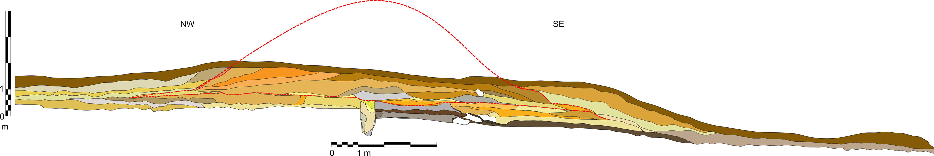
Figure 4 Profile of the rampart in its better-preserved part, with the original height and the base marked with red lines. Layers forming the embankment of the rampart (derived from the close vicinity of the settlement): brown and light brown: silty sediments; orange and yellowish-orange: clays; gray: loamy deposits; yellow and light yellow: sands, locally with clay.
MATERIAL AND METHODS
The 14C analysis encompassed 18 samples of charred wood collected during the excavations of the rampart area, including from the remains of charred timbers found in the bottom part of the rampart in its southeastern zone, from presumed gates, from the fill of the central ditch, and occasional charcoal fragments found in or near the bottom of the rampart (Table 1; Figure 3). The vast majority of these were very small, anatomically unidentifiable pieces of charcoal.
Table 1 The list of 14C dates for samples from the rampart of the hillfort in Chotyniec (LSC dating: lab code MKL; AMS dating: lab code MKL_A).

Charcoal samples were chemically pretreated using the acid-alkali-acid (AAA) method. Sixteen charcoal samples were combusted together with CuO and Ag in a pre-baked quartz ampoules. The ampoules containing the samples were evacuated to a pressure of 10-5 mbar, sealed and heated at 900ºC for 4 hr in a muffle oven. The resulting CO2 was collected under vacuum and purified cryogenically. Carbon from CO2 was converted to graphite using the Bosh reaction and an iron catalyst (e.g., Nadeau et al. Reference Nadeau, Grootes, Schleicher, Hasselberg, Rieck and Bitterling1998). The pretreatment and graphitization of all samples was performed in the laboratory at the AGH-UST in Kraków (Krąpiec et al. Reference Krąpiec, Rakowski, Huels, Wiktorowski and Hamann2018). The mixture of graphite and Fe powder was pressed into a target holder and measured with the AMS system at the Center for Applied Isotope Studies at the University of Georgia, USA (Cherkinsky et al. Reference Cherkinsky, Culp, Dvoracek and Noakes2010).
Two samples were dated using the conventional liquid scintillation spectrometry (LSC) 14C dating technique at the Laboratory of Absolute Dating in Kraków, Poland. After the sample was dried, further procedures included a standard synthesis of benzene from carbonized samples (Skripkin and Kovalyukh Reference Skripkin and Kovalyukh1998). Measurements were taken with a Hidex 300 SL spectrometer (Krąpiec and Walanus Reference Krąpiec and Walanus2011).
All dates were calibrated using the OxCal 4.4 calibration program (Bronk Ramsey and Lee Reference Bronk Ramsey and Lee2013) on the basis of the IntCal20 calibration curve (Reimer et al. Reference Reimer, Austin, Bard, Bayliss, Blackwell, Bronk Ramsey, Butzin, Cheng, Edwards and Friedrich2020). The chronology of the rampart remnants was determined based on a model calculated using the OxCal procedures (the Sequence command). Since all dated samples were charcoal, they were marked as outlier points when the model describing the phase was created in OxCal 4. The Outlier_Model(“Charcoal”,Exp(1,-10,0),U(0,3), “t”) described by Bronk Ramsey (Reference Bronk Ramsey2009) was assigned to each sample with probability equal to 1. The beginning and end of the phase were determined using the Boundary Begin/Boundary End commands, and its duration was calculated using the Phase function (Figure 5).

Figure 5 Modeled calendar age BC placements of the 14C-dated charcoal samples from the hillfort in Chotyniec. Probability distribution for calendar year values for the phases of construction of the rampart (below). The 14C dates are listed in Table 1.
RESULTS AND DISCUSSION
The absence of archaeological material (e.g., pottery or metal objects found in large numbers in the hillfort) within the construction layers of the rampart makes traditional relative dating impossible. In this situation, 14C dating appears to be the best indicator of the time of construction of the fortifications.
The dating results obtained are presented in Table 1. They are spread over a considerable time span, and two sets of dates can be distinguished among them.
The early dates comprise one set: 3383 ± 37, 3136 ± 25, and 2927 ± 24 BP. The earliest of these comes from a sample associated with the base of the rampart within the slope section of the natural elevation (Czopek et al. Reference Czopek, Trybała-Zawiślak, Tokarczyk, Ocadryga-Tokarczyk, Burghardt, Adamik-Proksa and Rajpold2017:Fig. 10) on which the rampart was built. The other two are from the lower embankment layers and are single, very small charcoal pieces that can be considered as a secondary deposit. They probably found their way to the layer accidentally during the construction of the embankment.
The second set is made up of samples coming from the lower layers of the southeastern and northern ramparts and from gates 2 and 3.
By comparing the samples coming from the period before the erection of the fortifications and those coming from the construction layers of the rampart and from the burnt wooden structures of the gates, a chronological model was developed assuming two chronological phases corresponding to these two sequences (Figure 5).
The chronological model indicates that the construction of the monumental fortifications protecting the settlement at Chotyniec should be dated to 651–595 or 531–409 BC (68.3% probability, Figure 5). One should not forget, however, that age estimations obtained from charcoal (especially from highly fragmented charcoal) tend to be older than the expected historical dating. The extent of this kind of “archaization” is difficult to determine though, and it varies highly from case to case.
Such dating is in good agreement with the chronology of the most important ritual and ceremonial feature within the Chotyniec settlement, the zolnik (Czopek and Krąpiec Reference Czopek and Krąpiec2020). Although it is not possible to prove that the rampart pre-dates the oldest zolnik horizon (or vice versa), they certainly belong to one chronological horizon. The 14C chronology does not provide a basis for drawing conclusions about the length of time it took to build the fortifications. Taking into account the reconstructed average size of the original embankment (perimeter: 2000 m, height: 3.5 m, width at the base: 15 m), the volume of this conical-sectioned earthen structure can be calculated as 52,500 m3. In the reality of the Early Iron Age, such a huge undertaking must have taken several years to complete. If we add the initial phase covering the construction of a central ditch with a palisade, the period becomes even longer.
14C dating of the rampart, falling most likely between the second half of the 7th and the first half of the 6th century BC, does not give a precise answer as to the moment when the rampart was erected, which should be taken as the beginning of the hillfort’s functioning. When compared with other Scythian fortified settlements from the eastern European forest-steppe zone, we cannot find any differences (Czopek Reference Czopek2021:382). These hillforts, like Severynivka (Ignaczak et al. Reference Ignaczak, Boltryk, Shelekhan, Lifantii and Olędzki2016), Motronin (Bessonova and Skoryi Reference Bessonova and Skoryi2001), or Chotiva (Kravchenko Reference Kravchenko2017), were established by the end of the 7th century. The earliest dated hillfort is Nemirov, whose beginnings can be traced back as early as the first phase of the Early Scythian period, i.e. the end of the 8th century BC (Smirnova et al. Reference Smirnova, Vakhtina, Kashuba and Starkova2018). The fact that Chotyniec occupies the same chronological position as hillforts from right-bank Ukraine allows for the general conclusion that the Chotyniec fortifications of interest to us here attest to the same genetic process (as to time and form) behind all sites of this type.
ACKNOWLEDGMENTS
This text is based on the results of research obtained during the implementation of the grant of the National Science Centre (2017/27/B/HS3/01460) entitled “On the border of two worlds. The Chotyniec agglomeration of the Scythian cultural circle – stage I: fieldwork”.


 Open access