


Chalk has provided a most attractive material for engraving for countless generations. It offers surfaces that can be smoothed, allowing designs to be sketched, reworked, altered, or erased accordingly. The material is irresistible; recent examples include a regimental badge carved by members of the Liverpool Pals regiment to document their presence in a World War 1 front line practice trench at Perham Down on Salisbury Plain, Wiltshire (Wessex Archaeology 2017). Prehistoric examples, when the raison d’être may have been different, span a range of creations from the scored lines on a chalk block from the Neolithic Enclosure ditch at Maiden Castle, Dorset (Laws Reference Laws and Sharples1991, fig. 170.1) and decorated chalk blocks incised with hatch markings from Tarrant Monkton, Dorset and Durrington Walls, Wiltshire (Dorset Archaeology 2005; Teather Reference Teather2008, fig. 5.12) to abstract marks on walls and blocks of chalk found in flint mines (Russell Reference Russell2000; Teather Reference Teather2011; Reference Teather2016) and shallow abstract engravings on the chalk ditch walls of a Neolithic enclosure at Flagstones, Dorset (Woodward Reference Woodward1988; Smith et al. Reference Smith, Healy, Allen, Morris, Barnes and Woodward1997). However, the most spectacular examples of prehistoric engraved chalk involve a small number of more portable objects, principally the three Folkton Drums, Folkton, North Yorkshire (Greenwell Reference Greenwell1890, 14–16) and two square plaques from a Late Neolithic pit, the Chalk Plaque Pit near Amesbury, Wiltshire (Vatcher Reference Vatcher1969; Harding Reference Harding1988; Cleal & Allen Reference Cleal and Allen1994, fig. 5). The Folkton Drums and the chalk plaques collectively provide the most frequently illustrated examples of engraved art on chalk from Britain.
The plaques from the Chalk Plaque Pit were described by Harding (Reference Harding1988) in the pages of this journal. That paper was written before accurate radiocarbon determinations were available which allow the objects to be discussed in more detail. It has withstood the test of time and remains the primary source for many authors. However, new techniques have now become available which make it possible to study these objects afresh to review their execution and place in the British Neolithic; re-evaluation is long overdue. In addition, two more fragmentary plaques are now known from the Stonehenge area, forming a small cohesive group for examination. The study therefore excludes the numerous other forms of engraved object, both mobile and static, which include those of chalk (Varndell Reference Varndell1991; Smith et al. Reference Smith, Healy, Allen, Morris, Barnes and Woodward1997; Green Reference Green2000; Russell Reference Russell2000; Teather Reference Teather2016) and other material (Warren Reference Warren1921) from across the British Isles.
The four incised plaques (Figs 1 and 2) have all been found within 5 km of one another in a cluster around Stonehenge. Those from the Chalk Plaque Pit have been joined by a broken example from Butterfield Down, Amesbury with another fragment from Bulford, only 7 km from Stonehenge. Apart from that at Bulford, the artefacts from this localised concentration have been published separately (Vatcher Reference Vatcher1969; Clarke et al. Reference Clarke, Cowie and Foxon1985; Harding Reference Harding1988; Rawlings & Fitzpatrick Reference Rawlings and Fitzpatrick1990; Lawson Reference Lawson1993). The entire collection has now been studied afresh using a computer enhancement technique for photography to review these objects, their manufacture, origins, and artistic influences.
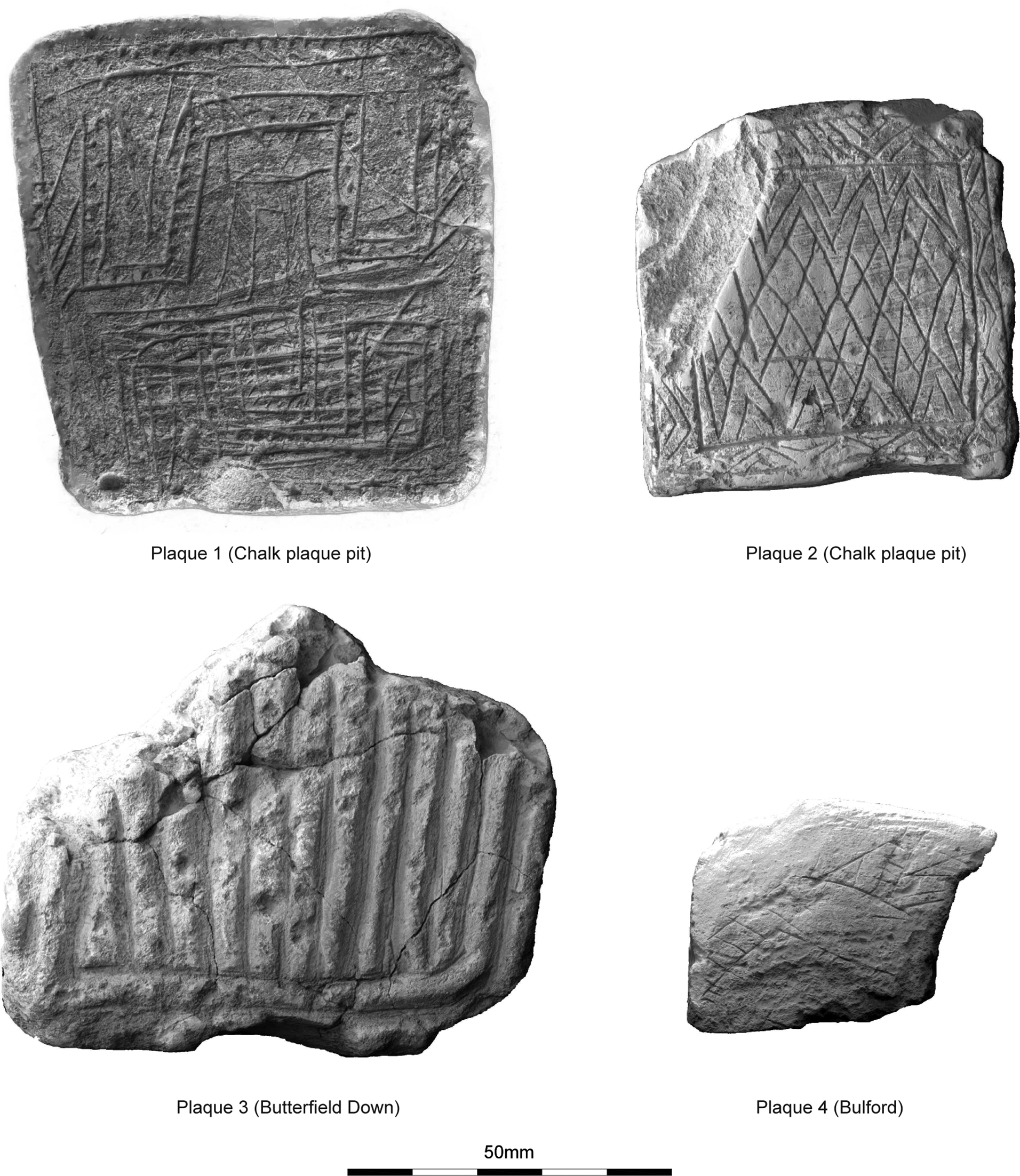
Fig. 1. Upper faces of all plaques

Fig. 2. Reverse faces of all plaques
PLAQUES
The plaques from the Chalk Plaque Pit (Plaques 1 and 2) were found during road-widening of the A303, west of King Barrow Ridge, in 1968. Both were inscribed with geometric designs and were accompanied by sherds of Late Neolithic Grooved Ware pottery attributed to the Clacton sub-style. Radiocarbon determinations from animal bone at the base of the pit returned dates of 3030–2580 cal bc; OxA-3316, 4250±80 bp and 2890–2560 cal bc; OxA-3317, 4130±80 bp (recalibrated using IntCal 20) providing some of the earliest Late Neolithic radiocarbon results then available from Salisbury Plain.
The Butterfield Down example (Plaque 3) came from a rectangular or slightly trapezoidal plaque which was found in a Romano-British pit (Rawlings & Fitzpatrick Reference Rawlings and Fitzpatrick1990; Lawson Reference Lawson1993). The plaque’s decoration comprises a series of vertical parallel incised lines on one side, surrounded by a narrow border. The opposing side is also decorated with two horizontal parallel bands, filled with vertical lines. The edges of the plaque had been scored with similar perpendicular grooves. The plaque remains undated; Rawlings and Fitzpatrick (Reference Rawlings and Fitzpatrick1990) made comparisons with the examples from the Chalk Plaque Pit but considered that the design was strongly influenced by Beaker decoration. However, Lawson (Reference Lawson1993) considered that the motifs were more reminiscent of Late Neolithic designs depicted on Orcadian art.
Most recently a fragment of an engraved chalk plaque (Plaque 4) was recovered from a Late Neolithic pit [9123] at Bulford, Wiltshire, containing Grooved Ware of the Woodlands sub-style and dated to approximately 2950 bc (Wessex Archaeology 2019). This feature lay within an arc of approximately 50 pits which all produced comparable radiocarbon results. The plaque fragment was found with a group of artefacts which were regarded as a deliberate refuse deposit and included chisel arrowheads, micro-denticulates, animal bone, antler, and pottery. The site also produced 22 other worked chalk objects including balls, cups, plaques, and working surfaces with other incised and miscellaneous categories (Smith Reference Smith1965; Varndell Reference Varndell1991; Teather Reference Teather2016).
In addition, objects listed as possible plaques are known from the Stonehenge area, including an undecorated example from a Middle Neolithic pit at West Amesbury Farm, c. 600 m from the Chalk Plaque Pit (Roberts et al. Reference Roberts, Barclay, Bishop, Bronk-Ramsey, Campbell, Canti, Dobie, Dunbar, Dunne, Evershed, Forward, Last, Lamb, Linford, Linford, Linscott, Madgwick, Marshall, Mays, McParland, Payne, Pelling, Pike, Price, Quinn, Radini, Reimer, Russell, Seager Smith, Soutar, Speller, Vallender, Valdez-Tullett, Van Heekeren and Worley2020), with others characterised by ‘scoured’ surfaces, including a further Middle Neolithic fragment from Greentrees School, Bishopdown, Salisbury (Wessex Archaeology 2015) and three fragments from a midden at Durrington Walls (Parker Pearson et al. Reference Parker Pearson, Pollard, Tilley, Thomas, Richards and Welham2005). Coarse corrugations of this sort can be produced when chalk is ‘scoured’ rapidly to produce powder, which may have been used for a variety of uses, including pigment. These objects are excluded from this study.
REFLECTANCE TRANSFORMATION IMAGING
The engraved objects from the Chalk Plaque Pit and Butterfield Down have previously been documented using hand-drawn illustrations supplemented by high resolution monochrome photographs. Harding (Reference Harding1988) conceded that parts of both plaques from the Chalk Plaque Pit were difficult to reconstruct due to apparent erosion of the chalk surface. Recent developments, however, in photographic surface reflectance techniques, including Reflectance Transformation Imaging (RTI) (Mudge et al. Reference Mudge, Voutaz, Schroer and Lum2005; Duffy Reference Duffy2018) and Polynomial Texture Mapping (PTM) (Malzbender et al. Reference Malzbender, Gelb and Wolters2001; Earl et al. Reference Earl, Martinez and Malzbender2010), allow objects and surfaces to be viewed in ways which provide greater image resolution. These techniques reveal detail that was hitherto obscure, increasing potential for revised discussion. The method provides a simple, cost effective, non-invasive technique to visualising optimal lighting conditions for photographic images. The data is easily transferrable and accessible, allowing constant re-examination and re-interpretation of the record. RTI has produced beneficial results in other studies of similar objects; however, other techniques exist which may be equally productive, including photogrammetry and laser scanning, which create detailed 3D models of an object’s surface.
Reflectance information is derived from the multi-lighting of the subject captured in numerous photographs. These are compiled in the RTI/PTM software and accessed through viewing software that provides an interactive ‘virtual’ lighting environment which can be easily manipulated by the user. This changing interplay of light and shadow in the image discloses fine details of the subject’s three-dimensional surface form (Malzbender et al. Reference Malzbender, Gelb, Wolters and Zuckerman2004; Earl et al. Reference Earl, Martinez and Malzbender2010). The two-dimensional nature of the photographs collectively become transformed into a high resolution dataset of lumination at the pixel level which reveals surface texture and simulates the three-dimensionality of the object.
Multi-light reflectance techniques were developed from their inception to examine artefacts (Earl et al. Reference Earl, Martinez and Malzbender2010) and subsequent studies have demonstrated that this can benefit analysis of a wide variety of materials and surface types (eg, Mudge et al. Reference Mudge, Voutaz, Schroer and Lum2005; Reference Mudge, Malzbender, Schroer and Lum2006; Earl et al. Reference Earl, Martinez and Malzbender2010; Duffy Reference Duffy2018), especially chalk and stone. The application of the technique to the Folkton Drums (Jones et al. Reference Jones, Cochrane, Carter, Dawson, Díaz-Guardamino, Kotoula and Minkin2015) revealed previously unrecorded motifs, evidence of erasure and reworking. Positive results were also obtained in a study of Norse Runes at Maeshowe, Orkney (Smith et al. Reference Smith, Beale, Richards and Scholma-Mason2018) where the technique was used to locate previously unrecognised detail in the engravings and illustrate the sequence of carving.
An opportunity arose to apply the technique to the plaques from the Chalk Plaque Pit, the Butterfield Down plaque, and the newly discovered fragment from Bulford. Analysis centred on the composition of the engravings, the sequences with which they were incised, and the execution of the lines. This collection provided a group of engraved chalk objects from the same locality that were likely to be contemporaneous, with contrasting execution and composition of design, as well as differing depositional and post-depositional histories.
METHODOLOGY
All four chalk plaques were individually recorded using a series of digital images at raking and oblique angles of light using a Canon Eos 5D MkIII Full Frame digital SLR camera following established guidelines (Cultural Heritage Imaging n.d.; Duffy Reference Duffy2018). RTI images were processed using open-source image builder software developed by the University of Minho in collaboration with Cultural Heritage Imaging and viewed via the RTI viewer (ISTI-CNR.CHI RTIViewer) (Cultural Heritage Imaging n.d.) and PTM viewer (Lyon Reference Lyon2004).
Both sides of each object were photographed (Figs 1 and 2) and processed, although only the main decorated sides are discussed in detail (see Supplementary Data).
The viewer software provides a number of rendering modes that perform mathematical transformations on the lighting scenario of the object. Diffuse gain (which improves granular contrast) and specular enhancement (which increases reflective quality, giving the object a metallic appearance) were found to provide the most informative results.
RESULTS
Additional detail has been observed on all plaques described previously. The revised descriptions for Plaques 1 and 2 from the Chalk Plaque Pit summarise the existing descriptions (Harding Reference Harding1988, fig. 2) with additional data obtained from RTI. The Butterfield Down plaque, Plaque 3, has also been described (Rawlings & Fitzpatrick Reference Rawlings and Fitzpatrick1990; Lawson Reference Lawson1993) but lacked the detail now available. The Bulford fragment, Plaque 4, has never been described and is included below with estimated dimensions (Table 1).
Table 1. plaque dimensions

* estimated
Plaque 1
The larger, slightly trapezoidal, plaque was described as having a border which encloses a design featuring an ‘opposing “Greek Key” or stepped pattern’ (Vatcher Reference Vatcher1969) (Fig. 3A). This meandering design contained three ‘panels’ which, like the parts of the border, were infilled with dotted and slashed decoration. Details of the plaque were initially difficult to interpret (Harding Reference Harding1988) due to traces of edge damage which may have resulted during use, burial, or excavation. The hand-drawn illustration (Harding Reference Harding1988, fig. 2) was oriented with the narrow tapering edge uppermost, although the photographs (op. cit., pl. 20) were inverted. Detailed examination of the RTI images has enhanced the prominence of one ‘Greek Key’, which is larger. It follows that these panels were probably inscribed before the mirror image, which is less-well drawn. The illustration used here consequently adopts the orientation used by Harding (Reference Harding1988, pl. 20) to reflect this.
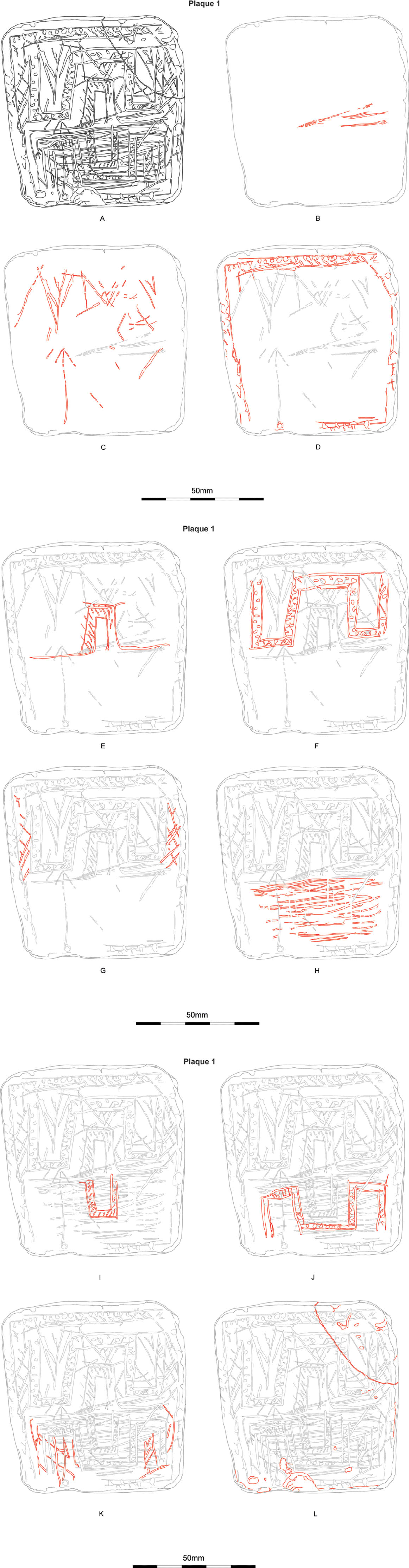
Fig. 3. Plaque 1 showing sequence of carving
The detailed study of the plaque incorporating RTI has revealed a systematic sequence of engraving (Figs 3–5). It has shown that traces of initial surface preparation survive as faint horizontal lines (Fig. 3B) which underlie all subsequent lines. More significantly, the process has highlighted a series of previously unrecognised, lightly incised, primary lines which apparently form poorly executed chevrons, parts of which clearly underlie the Greek Key design (Fig. 3C). Some of the chevrons, a design which recurs in prehistoric art and cannot therefore be dismissed without consideration, are deeper than others and include multiple recuts which appear at odds with other chevrons in this design. RTI suggests that these deeper lines precede the outer meanders of the Greek Key design and were not recut to infill zones enclosed by the Greek Key (Fig. 4A). A vertical ‘arrow’, the tip of which aligns with the projected mid-line of the plaque and which also underlies the Greek Key, is also included in this preliminary phase.

Fig. 4. Plaque 1 upper face showing details and features under RTI
The upper edge of the principal design comprises a narrow border which is formed by a pair of parallel lines. Single, less well executed lines around the other edges create a central panel (Fig. 3D). The upper border was infilled by a row of oblique lines with opposed short slashes. RTI has highlighted the execution of this design to reveal that it apparently depicts twisted or platted cord (Fig. 4B). Elsewhere detail of the infill remains vague, appearing as poorly defined, intermittent slashed lines or dots.
The Greek Key design, which fills the upper half of the central panel, was placed symmetrically within the border, although RTI failed to locate any points where lines of the two elements intersected. The design comprised an inner orthogonal arch which has incised horizontal lines that extend from the base of the inner arch to divide the larger upper half of the central panel from that below (Fig. 3E). The arch is partially infilled with diagonal lines, some of which extend beyond the edge of the border, confirming that they were added. This arch is surmounted symmetrically by three outer meanders, also composed of two parallel lines and partially infilled by the twisted cord motif which degenerates elsewhere into indented dots and slashes (Figs 3F & 4C).
RTI images indicate that the zones between the border and the outer meanders were infilled with loosely executed cross-hatching of varying depths (Fig. 3G). Diagonal lines filling the inner parts of the meanders arguably derive from the chevron design (Fig. 3C).
The lower half of the central panel is marked by a series of horizontal slashed lines (Fig. 3H). Initially these lines may appear to be random, which Harding (Reference Harding1988) conjectured represented attempts to remove an earlier design. However, RTI images (Figs 4D & 5) have shown that they are all generally horizontal, of similar depth, are contained within the outer border, show no evidence of run-out, and are restricted to the lower half of the central panel. These observations imply that they are deliberate and apparently superimposed on a more carefully prepared surface. No traces of an earlier design were detected, reinforcing the argument that they may have formed an important, integral part of the design and were cut with some degree of care, purpose, and intent.
The lower key designs, in all other respects, effectively mirror those of the upper half of the plaque (Fig. 3I–K). The lines and infills are poorly executed in comparison to the upper panels, possibly as a result of the irregular surface. This sequence is confirmed by the RTI image (Figs 4E & 5) which clearly indicates that the arches and infill cut through the horizontal lines. Traces of edge damage may have resulted during use, burial, or excavation; the top right-hand corner was broken and re-fixed as part of post-excavation conservation (Fig. 3L).
The surface of the reverse side, in contrast to the front, was scraped vertically to prepare the plaque before a lightly engraved, double lozenge design was added (Fig. 6). RTI also identified several deeper and wider lines which run through the lozenges.

Fig. 5. Lower part of Plaque 1 showing (left) raw data under specular enhancement mode with (right) engraved sequence showing selected phases: Fig. 3C (red), 3E (dark blue), 3F (yellow), 3H (green), 3I (light blue), and 3J (orange). Not to scale

Fig. 6. Plaque 1 reverse face showing lozenges and highlighting other lines
Plaque 2
The design on the smaller plaque can be summarised as a narrow border, formed from parallel lines and infilled with chevrons, which surrounds a central panel containing two rows of chevrons flanking two rows of lozenges, which are themselves sub-divided (Fig. 7A). The upper corner of the plaque, which bears unmistakable signs of conchoidal fracture due to impact, was probably detached before deposition. Analysis of the dominant pattern sequence in RTI viewer under various render modes is less clearly defined than in Plaque 1 but has nevertheless confirmed both the orientation and general sequence of engraving (Fig. 7C–K). This analysis has highlighted the complex geometry, which required clear planning, to compose the central panel.

Fig. 7. Plaque 2 showing sequence of carving
Surface preparation viewed under RTI survives as a series of shallow, sub-parallel inclined striae (Fig. 7B) which are more accentuated than those on Plaque 1. This surface preparation includes repeating patterns within the lines documenting the edge signature of the flint tool used in preparation (see below).
The data do nothing to contradict the likely sequence that the central panel was created after the outer border. The outer line, which respects the edge contour of the plaque, contrasts markedly with the inner edge of the border, which defined the central panel. No traces of ‘run-out’, produced by an implement being pulled or dragged through an underlying line, demonstrate well executed tool control (Fig. 7C). The border is infilled using continuous chevrons with additional small, angled cuts filling in the spaces between each chevron and the inner and outer edges of the border (Fig. 7D). This pattern was executed competently and continuously around most of the border but replaced in the upper left-hand corner by a series of shallow, angled lines.
RTI shows that the central panel was carefully sub-divided into thirds. An upper frieze (Fig. 7E) was apparently engraved first, placing the tip of the central chevron in the centre of the band and passing approximately a third of the way vertically from the top of the panel. A similar sequence was adopted along the base (Fig. 7F), carefully offsetting the peaks to ensure that they interlocked with those at the top. The two edges of the lower frieze were connected to the two ends of the upper band, a process that necessitated the upper frieze to be cut first. Both friezes were cut with care, displayed little or no evidence of run-out and were infilled with further lines. The tips of the two friezes were then joined by oblique lines to form a series of lozenges across the central third of the panel (Fig. 7G–H).
These lozenges were themselves sub-divided (Fig. 7I–J). The lozenges initially employed carefully executed parallel, oblique lines, which extended from the tips of the upper chevrons to the tips of the lower. Further sub-divisions of these lozenges proved to be more difficult to execute correctly (Fig. 8A). This ‘haphazard’ work is represented by short individual lines, creating small lozenges with slightly offset junction lines (Fig. 7J).

Fig. 8. Plaque 2 showing underlying surface preparation striae under RTI
Surface traces related to the use or destruction of the plaque were also identified. These included a negative flake scar facet in one corner and a horizontal gouge line that cut through the design within the lower third of the central panel (Fig. 7K).
The reverse side of the plaque is undecorated but has been dressed informally creating a series of shallow, angled scratched lines from right to left (Fig. 8B). A repeating tool signature was visible in RTI on both sides of the plaque (Fig. 8A and 8B) and suggests that the same tool with a narrow distinctive notch was used to prepare both surfaces of the plaque. This process can be achieved quickly and easily; no attempt was made to improve the surface by grinding or polishing.
Plaque 3
The plaque from Butterfield Down (Figs 1C & 2C) is damaged and the surface heavily abraded; deterioration which may have resulted from later Romano-British activity. Surviving detail suggests that it was roughly rectangular. It also differs from the others by being decorated equally on both sides and on two edges, a feature which also occurs on a plaque from a Roman ditch at Kilham, North Yorkshire (Varndell Reference Varndell1999). The decoration on the upper surface comprises a series of sub-parallel corrugations, set within a parallel border. An indistinct, shallow, oblique groove can be traced along part of the upper edge, possibly defining the inner edge of the border and creating an irregular compressed pentagon. The border around the sides and base is more distinct. The central panel was sub-divided into ten vertical columns.
The reverse side of the plaque is more extensively damaged, however, the surviving decoration comprises three panels. These are surrounded by parallel lines which define a border in low relief. This may indicate that the central area was reduced during the surface preparation. The upper and lower panels are both filled with vertical lines, creating a ‘ladder’ motif and are separated by a central undecorated panel, itself defined by horizontal lines. Indistinct traces of a chevron motif were also noted in the surviving corner. A faint horizontal line also passes through the apex of the chevron into the border (Fig. 1C).
The sequence in which each design was created could not be established with certainty, however it seems likely that the borders were created, in each case, before the panels were inscribed.
Plaque 4
The Bulford plaque is represented by a fragment, making it impossible to reconstruct the intended original design. If it was of comparable size to the plaques from the Chalk Plaque Pit it is estimated that the fragment represents 25–30% of the original piece. Incised lines are present on both sides (Figs 1D & 2D). The design on the upper face is sufficiently well executed to indicate that it constitutes conscious art; however, it is unclear whether the composition represents a doodle, part of a more elaborate design, or a sketchpad of ideas for further development. The sequence is impaired by surface erosion but has been reconstructed using visual observation supplemented by RTI (Fig. 9).

Fig. 9. Plaque 4 showing surface decoration under RTI. Not to scale
The general design differs from the other plaques in that it lacks a regular border or central panel. The composition was apparently formed around two oblique parallel lines which turned at right-angles where they become slightly wider (Fig. 10A). RTI has demonstrated that the upper line is a continuous cut with no signs of run-out or over-cutting marks (Fig. 10B). These lines were partially infilled using short, parallel lines to create two ‘ladder’ patterns, with angled lines across the wider parts of the sequence of parallel lines. The ladder pattern was repeated outside the parallel sequence of lines, where there are also a number of individual, angled lines (Fig. 10C). The design was overlain by two apparently unrelated, deep, parallel angled lines (Fig. 10D).

Fig. 10. Plaque 4 showing sequence of carving
The reverse side of the fragment is relatively even but shows no signs of surface preparation. The design comprises a series of lightly cut lines, which have been overlain by two confidently executed, narrow, leaf-shaped motifs (Fig. 2D). The lower of these is slightly wider and was inscribed first; the bottom line is well-defined while the upper element appears abraded and more indistinct. The second example, which consists of two converging curving lines, was cut with more emphasis and was clearly cut through the earlier design. The motif terminates in two sub-parallel lines, which extend beyond the edge of the fragment. The lines vary in width and depth and are generally cut from the outer edge of the fragment towards the centre.
Tool signature
The level of detail which becomes visible using RTI provides additional access to the creation process. Teather (Reference Teather2016) considered that flint blades/flakes formed the most likely engraving tools, conceding that a bone or wooden point could produce comparable results. Smith et al. (Reference Smith, Healy, Allen, Morris, Barnes and Woodward1997) similarly concluded that the engravings at Flagstones were made using flint flakes. A pilot study was undertaken to consider whether RTI could reveal characteristics and differing groove profiles created by individual inscribing tools by documenting how light reflects across the walls and base of the groove.
Two test plaques were therefore prepared by scraping blocks of chalk with a flint blade and engraved using flint and antler tools. The quality of surface preparation was determined by the evenness of the blade edge and the care with which this process was undertaken. One half of one test piece was subsequently ‘polished’ by hand, to refine the surface. Intersecting grid lines were then drawn across the chalk, using an unretouched flint flake, a flint piercer, an antler spatula, and an antler point.
The tests demonstrated that all tools worked efficiently, however the most positive results, comparable with those on the prehistoric plaques, were obtained using a flint flake. This tool created light, narrow, yet clearly executed lines with steeply angled, symmetrical side walls similar to those on the lower part of the Greek Key design on Plaque 1 and the ladder design of Plaque 4. These lines were replicated easily when the engraving tip was held perpendicular to the chalk surface.
The incised line may be influenced by the tip profile and composition of the inscribing tool, the degree of surface preparation, and the angle at which the tool was held. Plaque 1 contains the most diverse range of grooves including deep horizontal lines with broad profiles across the lower part of the plaque. Some of these lines have distinctly asymmetrical profiles where the lower side is inclined at a shallower angle than the upper side (Fig. 11A), an effect which was reproduced by replication (Fig. 11B), suggesting that the tool may have been drawn at an inclined angle across the surface of the chalk. Alternatively, they may reflect the asymmetrical tip of the tool.

Fig. 11. Comparative evidence of tool types between historic plaques and test plaques. Not to scale
Observations under RTI revealed distinctive feathering (Fig. 11C & D) – ‘drag’ lines along the upper edges of the groove – which, on examination, were present on Plaque 2. This characteristic, which might otherwise have remained undetected under normal conditions, was created by using a flake. It apparently resulted from material accumulating in front of the engraving tool, forcing out and tearing the edges of the groove. Further study revealed that the damage formed angles pointing in the direction of travel of the flint. Further tests may confirm whether this observation applies solely to flint or can be created by other materials.
Antler tools produced no distinctive characteristics which could be replicated on the chalk plaques. Grooves, predictably, were characterised by more rounded, wider profiles when viewed in RTI with no discernible edge damage. The grooves created by these tools appeared smoother and more ‘polished’ than those cut with flint. This created a more reflective appearance in the test pieces than the narrower grooves created by flint, although it is highly unlikely that this attribute would remain after millennia of burial.
These preliminary tests and the detailed observations endorse the probable use of flint as the preferred engraving tool, with nothing to support the use of antler. This simplistic conclusion may be muted by other factors including the frequency with which the line was cut and pressure exerted. The delicate ladder design on Plaque 4 was probably cut once, however more emphatic deeper, wider grooves undoubtedly required increased pressure or multiple cuts, as became apparent in the creation of the test pieces. Recutting can create double lines with small tell-tale ‘islands’ of chalk (Fig. 11E & F), which were noted on Plaques 1 and 4. Other repeated cuts may have been erased in the creation of the final line.
Surface attrition
The use of RTI in this study has primarily focused on issues of plaque manufacture; however, the technique can be used to consider surface attrition resulting from exposure to the elements or to excessive handling. Most plaques in the collection are relatively sharp and the detail well-defined; Plaque 3, which was found in a Romano-British pit, exhibits the most marked surface deterioration. Several plaques showed clear signs of edge damage which probably occurred before they were buried. One of the test pieces, in mint condition, was placed outdoors between early February and late April, to endure hard frost, wind, rain, and early spring warmth. The object was rephotographed using RTI after two days and finally after two months, to document changes to the surface (Fig. 12).

Fig. 12. Evidence of surface attrition on test plaque under RTI, not to scale
The initial results, after two rainy days, showed that the smooth surface, which had been polished with the thumb, comprised fine chalk dust that had been impressed into the surface corrugations of the chalk. This fine powder was washed out by the rain leaving the original scraped surface. The object otherwise remained virtually unaltered, with only minor softening of the incised lines, which could not be detected with the naked eye.
Climatic weathering contributed no significant further modification to the surface of the chalk in the following two month period. The surface preparation lines were unchanged from the day two image and the incised lines also remained clear. These observations are directly comparable with surface preservation of the prehistoric plaques, which shows that they could retain clarity, under certain conditions for relatively long periods.
These minimal effects from exposure to climatic weathering contrast sharply with results after the object was carried in a small cloth bag, possibly as a personal talisman, for two weeks in a trouser pocket. The RTI file documented marked changes to the surface of the chalk due to direct contact between the object and the cloth bag. These changes were readily observable to the naked eye. High spots and angular edges proved to be especially vulnerable. Polishing and rounding of previously sharp edges was most notable after this relatively short time period. Traces of surface preparation and of the incised designs remained discernible and relatively clear but were similarly reduced in resolution. Nothing comparable has been noted on any of the prehistoric chalk plaques.
As a supplementary issue the test piece sustained unforeseen impact damage when it was dislodged from its location by a high wind. Similar impact damage is present in one corner of Plaque 2 where a negative flake scar shows clear signs of conchoidal fracture. It is notable that most of the prehistoric plaques were broken or damaged, although it is unclear whether this resulted from deliberate breakage or was accidental before burial. None of the prehistoric pits contained plaque fragments that could be reconstructed.
DISCUSSION
The original hand-drawn figures and high resolution photographs which document the plaques from the Chalk Plaque Pit and Butterfield Down provided, and still do, accurate and reliable records of the objects; however the results of this project have confirmed that RTI provides an alternative method of illustration which can extract data the importance of which was not fully appreciated previously. The available catalogue of objects from the Stonehenge area has not only increased in number, highlighting variations in artistic composition and execution, but has also been supplemented by improved radiocarbon determinations which confirm chronological links between the designs used on the plaques across Britain.
The plaques are predominantly square, but of variable sizes. Three examples were found in pits; however, the dimensions suggest that these objects were not manufactured from rubbly surface chalk obtained from pit up-cast. Plaque blanks were apparently prepared from massive blocks from deep excavations and were trimmed to an appropriate size before they were engraved. Blocks of this size were invariably found only in the lower parts of monumental ditches, in contrast to the rubbly surface chalk into which pits were cut.
Surface preparation and design vary; well executed compositions as seen on the plaques from the Chalk Plaque Pit and Butterfield Down exist with more ephemeral sketches, of the type noted at Bulford. Some designs were executed on both sides but elsewhere only on one. Beneficial use of RTI has revealed sequences showing deliberate, staged composition, execution, and detail to construct accomplished designs on most plaques, especially those from the Chalk Plaque Pit. It has indicated that the Greek Key design was apparently superimposed on a crudely executed chevron pattern, which may have served as a template for the geometric chevron and lozenge design on Plaque 2. This design on Plaque 2 was inserted within a clearly defined central panel, using systematic mathematical sub-division of the space within each lozenge. This process whereby designs were conceived, inscribed and erased echoes results made by RTI on the Folkton Drums (Jones et al. Reference Jones, Cochrane, Carter, Dawson, Díaz-Guardamino, Kotoula and Minkin2015) which showed similar superimposition.
Inevitably, study has focused on the principal designs, although motifs on the reverse, no matter how indecipherable, may have been of equal importance, representing a personal or identifying mark with meaning, communicating to those who could read it.
Test pieces have indicated that plaques were relatively robust, durable objects capable of withstanding exposure without developing undue surface weathering. This allowed them prolonged use before they were buried, possibly remaining in personal possession carrying enduring symbolism or gift value. Furthermore, the plaques from Butterfield Down and Kilham (Varndell Reference Varndell1999) were found in features of Romano-British date, making it possible that they achieved a second life, retaining elements of fascination with the past for later collectors.
Stonehenge
The distinctive Greek Key design on Plaque 1 formed not only the basis of the design but, with its textured squared central arch and outer key, provided a deliberate ‘horizon’ line separating the upper and lower halves. The motif is not common but has been paralleled by a design which appears on a sherd of Grooved Ware pottery from Marden, Wiltshire (Harding Reference Harding1988) hinting that this angular design may have persisted into the mid-3rd millennium bc.
The concept of the design remains essentially abstract but may have been stimulated by physical objects with which the artist was familiar, featuring a textured inner stone or wooden portal placed on a horizon or ground surface, all reflected in the lower half of the plaque. The horizontal grooves in the lower part of the plaque, which lie within the outer border, may become a fluvial component of the intended design rather than erasing or correcting an earlier one.
Elements of the design bear an undeniable similarity to the Stonehenge Trilithons and it is tempting to suggest that this is what the plaque represents: Stonehenge reflected in its water-filled ditch. This hypothesis is, however, untenable: radiocarbon dating places the Chalk Plaque Pit in the first half of the 3rd millennium (Cleal et al. Reference Cleal, Cooper and Williams1994), considerably earlier than the sarsen elements of Stonehenge, and it is unlikely that the Stonehenge ditch ever held water.
There is another possibility. Some of the Stonehenge bluestones have tenons and, consequently, once bore lintels. The history of the bluestones since their arrival on Salisbury Plain from Wales is complex and the date, sequence, and timing of their erection, dismantling, and re-erection is not fully understood. However, some of the bluestones may have formed a circle within Stonehenge (the Aubrey Hole circle) as early as the 2900s, while others may have formed parts of circles prior to their inclusion in Stonehenge. These may have included the circle within the henge at West Amesbury (Allen et al. Reference Allen, Chan, Cleal, French, Marshall, Pollard, Pullen, Richards, Ruggles, Robinson, Rylatt, Thomas, Welham and Parker Pearson2016; Parker Pearson et al. Reference Parker Pearson, Pollard, Richards, Thomas, Tilley and Welham2020) at the end of the Stonehenge Avenue on the Avon’s western bank and close enough to the river to have been reflected in it. Dates for the circle’s construction were not obtained but antlers in the voids created when the circle was dismantled place it before 2469–2286 and 2460–2270 cal bc. Two chisel arrowheads from packing deposits, one each in Stone-holes A and K (Allen et al. Reference Allen, Chan, Cleal, French, Marshall, Pollard, Pullen, Richards, Ruggles, Robinson, Rylatt, Thomas, Welham and Parker Pearson2016), suggest a significantly earlier date for the circle’s use. These arrowheads characterised the Middle Neolithic and persisted into the Late Neolithic at Bulford (Wessex Archaeology 2019) where dates of around 2950 cal bc were obtained. These results constitute some of the earliest Late Neolithic dates from southern England, only marginally earlier than those from the Chalk Plaque Pit.
Several criteria must be met if Plaque 1 can be considered to represent the bluestone circle that may have stood inside West Amesbury Henge on the banks of the Avon, reflected in the river’s water. First, do the dimensions of the circle suggest that there could have been trilithons (assuming that the dimensions of the Stonehenge bluestones are in any way indicative of the West Amesbury examples)? The centres of the excavated stone-holes at West Amesbury are, on average, 1.16 m apart. The surviving stones of the bluestone oval at the centre of Stonehenge are considerably longer than this, averaging 2.2 m. The stones of the bluestone circle however are somewhat shorter – averaging 1.4 m with less complete examples, which could conceivably have functioned as lintels. Field et al. Reference Field, Anderson-Whymark, Linford, Barber, Bowden, Linford and Topping2015 note that four bluestones (67, 69, 70, and 72) bear scars from the removal of tenons, while stones 150 and 36 are lintels re-used as uprights.
Stone 36 is 1.83 m long, with a centre-to-centre gap between the mortises of 0.85 m, while Stone 150 is 2.44 m long, although the centre-to-centre gap is only 1.04 m. While neither is an exact fit for the West Amesbury circle’s average distances, the measurements are not excessively distant.
Secondly, is there any demonstrable relationship between the Chalk Plaque Pit and the bluestone circle at West Amesbury? The most obvious link would be the Stonehenge Avenue but the course of this bypasses the Chalk Plaque Pit very markedly. Mike Parker Pearson has suggested that the Avenue may mark the route taken by the renovators of Stonehenge as they transported the bluestones from the dismantled West Amesbury circle, while an earlier, more direct route between the two crossed Coneybury Hill before descending towards Stonehenge’s southern or north-eastern entrances (2012, 226). Such a route passes very much closer to the Chalk Plaque Pit and it is possible that the pit marks the route or, depending on where in the distribution of radiocarbon dates its use actually lies, its ‘closure’.
Thirdly, representational art in the British Neolithic is a more difficult issue, simply because there is so little material which is not purely abstract. Thomas notes the scarcity (2005) of representational art, particularly the lack of figurines, but does list a very small number of definite and possible examples, all admittedly three-dimensional carvings of bodies or body parts. The number remains low; additional figurines have been found on Orkney (Moore & Wilson Reference Moore and Wilson2013) and more recently discovered or reconsidered pieces continue this trend: where figurative or representative art is recognised, it is in every case bodily (Jones & Díaz-Guardemino Reference Jones and Díaz-Guardamino2019, 190–2). This at least suggests that Neolithic ‘artists’ were capable of representing real objects when they chose, confirmed by the apparent representation of twisted cord which formed part of the Greek Key design on Plaque 1.
Design and origins
The artistic elements on the plaques predominantly feature straight, incised lines, Teather’s (Reference Teather2016) linear designs, to create angular, linear compositions or geometric patterns, some with, others without enclosing panels. The lines were drawn freehand with designs varying in execution and quality. Spirals, cup-marks, and circles, which feature in Neolithic rock art, are conspicuously absent. The rare execution of curvilinear decoration on chalk was noted by the staggered lines which characterised concentric patterns at Flagstones (Smith et al. Reference Smith, Healy, Allen, Morris, Barnes and Woodward1997). Similarly, irregularities in the circular decorations on the base of the Folkton Drums also show limitations imposed by inscribing circles freehand.
The recurring use of incised geometric designs, composed of chevrons and lozenges, supplemented with ‘ladder’ motifs (Table 2) can be traced from the Middle Neolithic to the Early Bronze Age. Such skills were probably well rehearsed and readily transferable to the laying-out of decoration on chalk. Motifs may have been motivated as much by tribal styles drawn from traditional influences or familiar objects as by individual character or personality and artistic inheritance of each artist. The compositions and stylistic features can be paralleled, and may have been inspired, by designs used to embellish contemporary Late Neolithic pottery (Varndell Reference Varndell1999) including the earliest Late Neolithic Orcadian/Woodlands collections. This is especially notable at the Ness of Brodgar, Orkney (Card & Thomas Reference Card and Thomas2012) where excavations have produced over 800 pieces of Late Neolithic art, not only on pottery but also on stone. Some decoration has been applied to the edges of decorated stone slabs which were incorporated in structures (Thomas Reference Thomas2019) and may replicate the linear infilling shown on the ‘lintels’ of the Greek Key design in the Chalk Plaque Pit. Parallels can also be made with the plaques from Butterfield Down and Kilham where engraving extended onto the edges of each plaque (Jones & Díaz-Guardamino Reference Jones and Díaz-Guardamino2019).
Table 2. design attributes

Designs were predominantly incised; however, others, formed in low relief as at Butterfield Down, may echo the use of applied, decorated cordons which also feature on Grooved Ware pottery. Cordons were, themselves, frequently embellished with a range of motifs including the apparent use of twisted cord (as replicated in plastic form on Plaque 1), ‘ladder’ motifs (depicted crudely on Plaque 4 and in a more refined example on Plaque 3) which may also been seen as a representation of whipped cord, and stabbed dotted infill. Wainwright and Longworth (Reference Wainwright and Longworth1971) noted that twisted and whipped cord did not feature in the Clacton sub-style but that both were present in the Durrington Walls sub-style of Grooved Ware. The deliberate execution of this motif, albeit discontinuously, on Plaque 1 from the Chalk Plaque Pit seems to be more than mere serendipity. Furthermore, Woodlands/Orcadian Grooved Ware both make full use of features, including ‘knots’, which create a familiarity between cord and pottery forms.
The plaques in this localised concentration were, apart from the Butterfield Down example, recovered from well stratified pit assemblages, which associated radiocarbon dates place in the early part of the British Late Neolithic. Animal bone from the Chalk Plaque Pit, which also contained pottery of the Clacton sub-style produced results between 3030–2580 and 2890–2560 cal bc. Eighteen dates obtained from animal bone, antler, and charcoal in 12 pits, with pottery of the Woodlands sub-style, at Bulford returned consistent dates of around 2950 cal bc (Wessex Archaeology 2019). These determinations indicate a close relationship between two sub-styles of Grooved Ware pottery, both with chalk plaques, in southern England in the earlier part of the Late Neolithic. Furthermore, the radiocarbon dates also confirm links with the development and chronology of contemporary early Orcadian Late Neolithic Grooved Ware where dates after 3160–3090 cal bc were obtained at Barnhouse (Richards et al. Reference Richards, Jones, MacSween, Sheridan, Dunbar, Reimer, Bayliss, Griffiths and Whittle2016). Construction dates for the enclosure at Flagstones (Smith et al. Reference Smith, Healy, Allen, Morris, Barnes and Woodward1997) have similarly produced results (HAR-9158 and OxA-2322) in the early part of the 3rd millennium while comparable estimations at the close of the 4th millennium (Loveday & Barclay Reference Loveday and Barclay2010) have been made for the Folkton Drums.
Engraved plaques from the Wolds of Yorkshire and North Downs of Kent (Varndell Reference Varndell1999) indicate that these set design patterns on chalk was not restricted to Wessex. Furthermore, an oval plaque from Graig Lwyd, Conwy (Warren Reference Warren1921, fig. 21), decorated with a sequence of incised lines and triangles, demonstrates this form of mobile art in Wales. Whittle et al. (Reference Whittle, Healy and Bayliss2011, 785) considered that Graig Lwyd, known for its axe factory, was probably exploited by the mid-4th millennium but noted that production may have continued into the 3rd, a date supported by results from henge B at Llandygai (Lynch & Musson Reference Lynch and Musson2001). However, despite the known movement of people and pottery designs across the country these decorated objects appear to have remained firmly within their source areas.
The origins of using chalk as a canvas for engraved plaques and the broader concept of art draw inspiration from both the Middle and Late Neolithic traditions. The uninscribed plaque (Roberts et al. Reference Roberts, Barclay, Bishop, Bronk-Ramsey, Campbell, Canti, Dobie, Dunbar, Dunne, Evershed, Forward, Last, Lamb, Linford, Linford, Linscott, Madgwick, Marshall, Mays, McParland, Payne, Pelling, Pike, Price, Quinn, Radini, Reimer, Russell, Seager Smith, Soutar, Speller, Vallender, Valdez-Tullett, Van Heekeren and Worley2020), found with Peterborough Ware pottery c. 600 m from the Chalk Plaque Pit and the probable example from Greentrees School, Salisbury (Wessex Archaeology 2015) indicate potential roots within the Middle Neolithic. The Middle Neolithic assemblages from West Amesbury Farm share closer chronological links with the Late Neolithic groups from the Chalk Plaque Pit and Bulford than these sites do with the Late Neolithic site at Durrington Walls and it is therefore not surprising that they share other similarities. These include not only worked chalk but also chisel arrowheads, perforated fossil beads of the Porosphaera globularis family, and the ability to produce controlled blades. Late Neolithic Orcadian influences were undoubtedly incorporated into this existing tradition, bringing not only the introduction of new pottery styles but also other artistic forms. Moore and Wilson have described the presence of deliberate ‘compositions’ (Reference Moore and Wilson2013, 15) at the Links of Notland, comprising arranged articles which arguably transcend elements of structured deposition (Richards & Thomas Reference Richards, Thomas, Bradley and Gardiner1984) which are common in Neolithic deposits. A specific example included a scallop shell which had been placed between the horns of a sheep skull. A similar anomalous ‘composition’ was found in a Late Neolithic pit at Bulford, where a splayed aurochs’ horn and conjoining red deer antler were capped by a large flint nodule, which all covered a large sherd of pottery, forming a seemingly abstract creation which pre-dated Picasso’s Bull by several millennia.
CONCLUSION
The Chalk Plaque Pit, discovered in 1968, provided a major stimulus to the study of Late Neolithic art on chalk in southern Britain. The passage of time has not only seen additional plaques discovered from the Stonehenge area but also improved techniques with which to analyse the objects. Improved radiocarbon dates have refined their chronological and cultural context.
The use of RTI has broken down the intricate process by which the designs on each plaque from this restricted area were executed. In the case of the Chalk Plaque Pit plaques particularly, indications are strongly towards pre-meditated designs executed deliberately, with specific end-goals in mind: there is little evidence of erasure, reworking, or expediency on these examples. The RTI study has highlighted a range of artistic ability by which predominantly geometric designs were applied to each plaque, demonstrating not only deliberate, staged composition, execution, and detail, but also allowing a reconsideration of the intent of the Neolithic artists: in one instance it is possible to suggest (however tentatively) that the designs were not abstract but, rather, drew on objects known to the artist in the real world.
Advances in the chronological framework of the Late Neolithic have confirmed that these motifs and artistic styles were well established in the 3rd millennium bc in the Orcadian Neolithic and were probably adopted soon after in southern England. The wider study has hinted that the adoption of these artistic styles may have been integrated into elements of existing Middle Neolithic culture. Engraved chalk objects can be traced throughout the Neolithic period; however, the concentration of distinctive composition may mark the Late Neolithic period as a truly golden age for the manufacture of Neolithic chalk art in Britain.
Acknowledgements
The authors wish to thank Martin Allfrey, Senior Curator of Collections (West) at English Heritage and to Adrian Green, Director of Salisbury Museum for access to Plaques 1, 2, and 3. Plaque 4 is currently stored at the offices of Wessex Archaeology until its final deposition with the other plaques in Salisbury Museum. Matt Leivers would like to thank Erica Gittins for suggesting possibilities other than Stonehenge for the Plaque 1 design. The authors also wish to extend gratitude to Kenneth Lymer for reading and commenting on the initial script, to staff at Wessex Archaeology in the compilation of graphics, and to Philippa Bradley for editorial advice. Finally, thanks are extended to the anonymous referees who have raised valid points which have improved the final content of this paper.
SUPPLEMENTARY DATA
To view supplementary material for this article, please visit https://doi.org/10.1017/ppr.2021.13


 Open access