Article contents
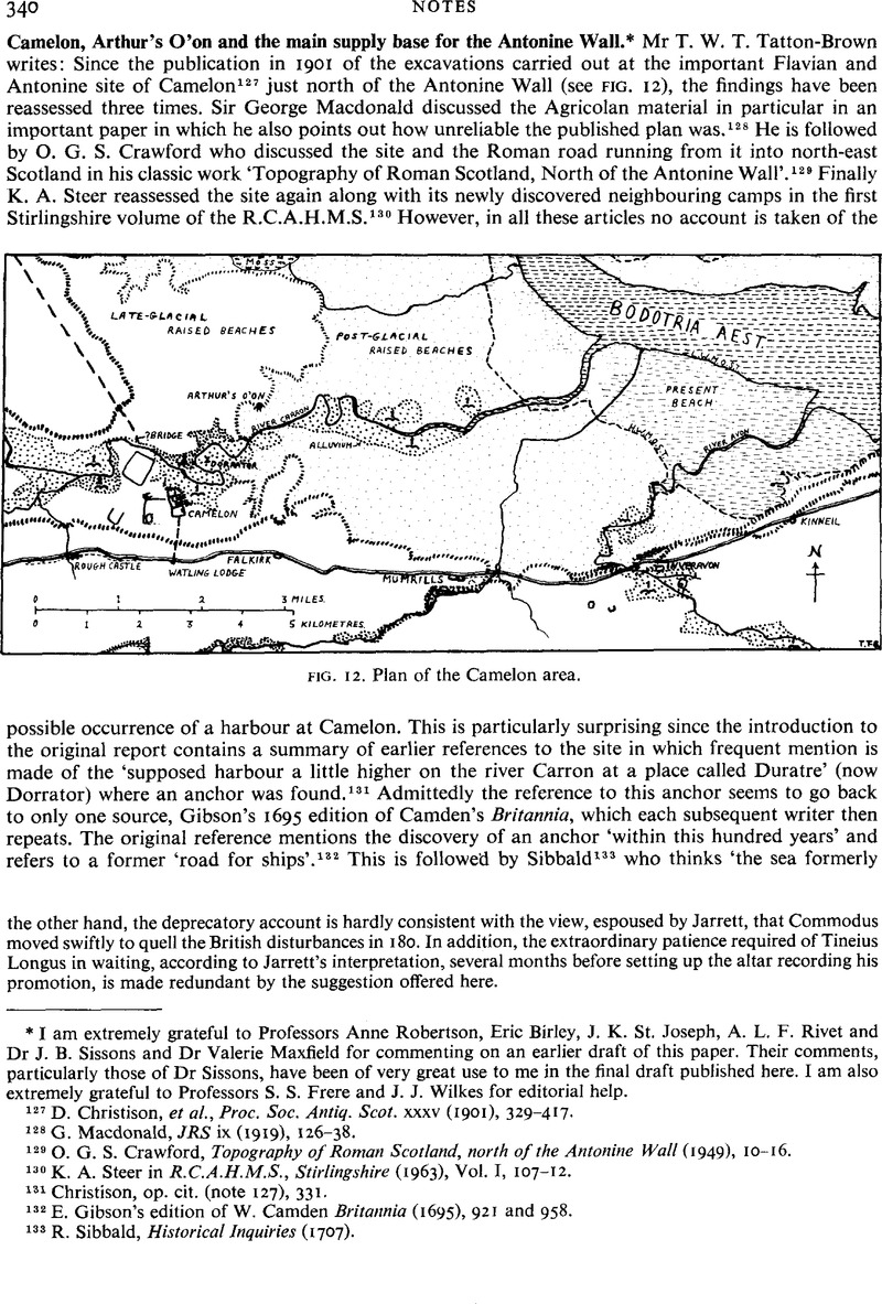
Camelon, Arthur's O'on and the main supply base for the Antonine Wall.*
Published online by Cambridge University Press: 09 November 2011
Abstract

- Type
- Notes
- Information
- Copyright
- Copyright © Mr T. W. T. Tatton-Brown 1980. Exclusive Licence to Publish: The Society for the Promotion of Roman Studies
References
127 Christison, D. et al. , Proc. Soc. Antiq. Scot, xxxv (1901), 329–417.Google Scholar
128 Macdonald, G., JRS ix (1919), 126–38.Google Scholar
129 O. G. S. Crawford, Topography of Roman Scotland, north of the Antonine Wall (1949), 10–16.
130 Steer, K. A. in R.C.A.H.M.S., Stirlingshire (1963), Vol. I, 107–12.Google Scholar
131 Christison, op. cit. (note 127), 331.
132 E. Gibson's edition of W. Camden Britannia (1695), 921 and 958.
133 R. Sibbald, Historical Inquiries (1707).
134 Maitland, W., The History and Antiquities of Scotland i (1757), 206.Google Scholar
135 R. Stuart, Caledonia Romana (1852) and in Christison, op. cit. (note 127), 331.
136 Steer, K. A., ‘Arthur's O'on : A lost shrine of Roman Britain’, Arch. Journ. cxv (1958), 99Google Scholar and more recently Glasgow Arch. Journ. iv (1976), 90–2.Google Scholar
137 J. B. Sissons, The Evolution of Scotland's Scenery (1976).
138 E. H. Francis, I. H. Forsyth, W. A. Read and M. Armstrong, The Geology of the Stirling District (1970), Sheet Memoir No. 39.
139 J. B. Sissons, op. cit. (note 137), 185 an d fig. 82.
140 Some reclamation of land east of Grangemouth docks is still going on.
141 Francis, et al., op. cit. (note 138).
142 Sissons, op. cit. (note 137), 218, fig. 88.
143 Nimmo, History of Stirlingshire (1777), 21.
144 A rocky band crossing the river near this point today acts as a natural rapid.
145 A. S. Robertson, Glasgow Arch. Journ. (1969), 39–42.
146 Christison, op. cit. (note 127).
147 Steer, op. cit. (1963), (note 130), 108.
148 ibid, and Crawford, op. cit. (note 129).
149 See notes by E. J. Price in Discovery and Excavation in Scotland (1972–4 and 1976) and by Dr Maxfield, Valerie in Britannia vii (1976), 300 and viii (1978), 362–4Google Scholar.
150 J. P. Gillam, in C.B.A. Research Report 10, Current Research in Romano-British Coarse Pottery, ed. A. P. Detsicas (1973), 55.
151 Feachem, R. W., Proc. Soc. Antiq. Scot, lxxxix (1965), 329–39.Google Scholar
152 W. J. Watson, Celtic Place-Names of Scotland (1927), 33 quoted in Crawford, op. cit. (note 129), 15.
153 Christison, op. cit. (note 127).
154 Steer, op. cit. (1958) (note 136), 109.
155 Richmond, I. A., Proc. Soc. Antiq. Scot, lvi (1922), 288–301.Google Scholar
156 Professor A. L. F. Rivet in his recent ‘Ptolemy's Geography and the Flavian invasion of Scotland’ in Haupt, D. and Horn, H. G. (edd.), Studien zu den Militdrgrenzen Roms II (Koln und Bonn, 1977), 45–64Google Scholar however suggests Victoria is Inchtuthil and Colonia is Camelon.
157 Geogr. ii, 3, 9.
158 Richmond, I. A. and Crawford, O. G. S., Archaeologia xciii (1949), 49.Google Scholar
- 2
- Cited by


