


INTRODUCTION
The modern political map of Africa reflects the European partition of the continent in the late nineteenth century. Small coastal settlements suddenly mushroomed into large colonies that, at least on paper, stretched nearly the entire continent. After independence, African state leaders largely retained the colonial-era international borders. Consequently, “the boundaries were, in many ways, the most consequential part of the colonial state” (Herbst Reference Herbst2000, 94). A large literature examines the consequences of external border formation in Africa for outcomes such as civil conflict (Englebert, Tarango, and Carter Reference Englebert, Tarango and Carter2002; Michalopoulos and Papaioannou Reference Michalopoulos and Papaioannou2016), international territorial disputes (Goemans and Schultz Reference Goemans and Schultz2017; Touval Reference Touval1972), economic development (Alesina, Easterly, and Matuszeski Reference Alesina, Easterly and Matuszeski2011; Michalopoulos and Papaioannou Reference Michalopoulos and Papaioannou2013), and political identities (Posner Reference Posner2004; Robinson Reference Robinson2016). Numerous other studies analyze specific bilateral borders and premise their research design on the as-if randomness of border location (McCauley and Posner Reference McCauley and Posner2015). Across this literature, the well-established conventional wisdom is that external influence yielded arbitrarily located boundaries in Africa:
-
Claim 1. Process of forming borders. European actors knew very little about conditions on the ground when they determined Africa’s borders. The Berlin Conference of 1884–85 was a pivotal event for border formation; at the Conference and afterward, Europeans dictated the process from their capital cities without African input.
-
Claim 2. Arbitrarily located borders. This process resulted in arbitrarily located borders, a majority of which were straight lines, that neglected local features. Ethnic groups and historical states were partitioned via an as-if random process, in the sense that local features do not systematically correlate with the location of borders.Footnote 1
We revise the conventional wisdom by demonstrating that the location of borders in Africa cannot generally be characterized as arbitrary. Instead, border formation in Africa was a dynamic process that was typically influenced by realities on the ground, in particular, historical political frontiers and major geographical features. Despite intense interest in African border formation and its consequences, the literature exhibits a crucial gap: the absence of systematic evidence about how colonial borders were actually formed. This historical process is important to study in its own right because it yielded the modern-day countries in Africa and, thus, its contemporary political map. Moreover, scholarly interest in studying the consequences of African borders underscores the need to understand the origins of these borders—which we show reflected a deliberate, rather than haphazard, process.
African borders were formed later-than-realized, as we document with new data. As late as 1887, European claims were largely limited to the coast, and few borders had taken their final form. This reflected the relative insignificance of the 1884–85 Berlin Conference for border formation. The Conference addressed the Congo region only, and the boundaries it created for the Congo Free State were later revised. Among all bilateral borders, the median years of initial and final border formation were 1891 and 1908, respectively. Although rough spheres of influence were largely resolved by the late 1890s, interimperial borders continued to be revised during the interwar period, and intraimperial borders even later.
We provide an alternative theory to understand African border formation. Our new facts about late border formation matter because, in the interim, Europeans learned about and adjusted to realities on the ground. Their self-interested motives to defend and extend territorial claims required local knowledge. Precolonial states and water bodies were pivotal in this process. These features attracted European strategic interest and provided focal points, or “frontier zones,” for determining specific borders.Footnote 2 To minimize intra-European conflict amid intense deliberations, European powers agreed on the principle of suzerainty: a power that signed a recognized treaty with an African ruler gained all the territory within their domain. This encouraged using historical frontiers as guides for borders, rather than partitioning precolonial states. Although Europeans directed the broader project of creating new states, the need to gather information enabled African agency to influence the location of borders, as African rulers had greater knowledge of their claimed domains. In some cases, Africans participated directly in negotiations that determined colonial borders. Europeans were also intensely interested in major water bodies and their derivatives to facilitate trade. Multiple powers routinely competed for influence over particular rivers and lakes, which were focal for settling borders. The most frequently emphasized attribute of African borders, straight lines, was expedient only in areas that lacked discernible local features, often low-population-density areas such as deserts. In sum, we expect that borders should align with the boundaries of precolonial states but not partition them, and that water bodies should be used to form borders.
We find empirical support for these implications using two original datasets. Quantitatively, we conduct a statistical analysis using square grid cells. We show that border segments are more likely in cells with rivers, lakes, and the frontiers of precolonial states; but less likely in cells contained entirely within precolonial states. The findings for precolonial states incorporate an originally compiled spatial dataset based on detailed maps of African regions from Ajayi and Crowder (Reference Ajayi and Crowder1985) and numerous additional historical maps for individual states.Footnote 3 Our new data improve upon the commonly used map of ethnic groups from Murdock (Reference Murdock1959). We agree with the descriptive claim in existing work that many ethnic groups were partitioned across international borders (Asiwaju Reference Asiwaju1985; Miles Reference Miles2014), which Michalopoulos and Papaioannou (Reference Michalopoulos and Papaioannou2016) confirmed using the Murdock data. However, we contend that the Murdock data cannot be used to adequately assess whether precolonial states affected country borders or, more generally, whether border formation was haphazard (see Supplementary Appendix A.3).
Our second original dataset is based on case studies of all 107 bilateral borders in Africa. In addition to providing general historical background on each border, we code three specific variables: primary and secondary physical features of the border, years of major border revisions, and whether a historical political frontier (usually a precolonial African state, but sometimes other frontiers such as white settlements) directly affected the border. We refer to the latter variable as causal process observations (Collier Reference Collier2011) because our subjective assessment of “direct effect” concerns the process of border formation. Our coding decisions are based on over one hundred pages of notes.Footnote 4
Historical political frontiers directly affected 62% of all bilateral borders, 66 of 107; and precolonial African states directly affected 47 different bilateral borders. This finding contrasts with existing discussions, which dismiss any notable role for historical political frontiers in shaping African borders.Footnote 5 Coding a direct effect requires us to find evidence that Europeans deliberately set a border in an area known to correspond with a particular historical frontier. We code this variable using rich historical information on Europeans’ interactions with Africans to learn about historical frontiers and their usage of this information in interimperial negotiations and intraimperial administrative decisions. We also find that water bodies, often major ones, much more frequently comprised the primary element of a bilateral border than straight lines, 63% versus 37%. This contrasts with commonly stated claims that overemphasize the prevalence of straight-line borders; for example, Alesina, Easterly and Matuszeski (Reference Alesina, Easterly and Matuszeski2011, 246) assert that “[e]ighty percent of African borders follow latitudinal and longitudinal lines.”Footnote 6 We demonstrate that such borders are mostly confined to desert areas of lesser strategic importance.
Our findings reject both strong and weak versions of claims that Africa’s borders are, generally, arbitrarily located. The strong version of this claim is that local features are systematically uncorrelated with the location of African borders. The weak version is that the only features systematically related to borders are orthogonal to human experiences on the ground. Our findings about precolonial states unambiguously reject both. The results for major water bodies clearly reject the strong version, and we contend they also reject the weak version. In contrast to astronomical lines, water bodies shaped human experiences by shaping the core and reach of both precolonial civilizations and trade networks.
The idea that Africa’s international borders are largely arbitrary is as foundational as it is misguided. Overturning this conventional wisdom provides new insights into the origins of contemporary African countries and the resultant political map, which has subsequently influenced domestic and international political institutions. We conclude with implications for using African borders in regression-discontinuity designs and for studying legacies of precolonial states. We also highlight other ways in which externally imposed state formation produced harmful outcomes.
HISTORICAL BACKGROUND: IT DIDN’T HAPPEN AT BERLIN
The conventional wisdom is that Europeans knew very little about conditions on the ground when they determined Africa’s borders. Many characterize the Berlin Congo Conference of 1884–85 as a pivotal event in a process of border formation that was directed entirely from European capitals without African input. Countering this view, we demonstrate that Africa’s borders were formed later than realized. We provide novel quantitative evidence that supports a long-standing contention by many historians that the Berlin Conference was largely irrelevant for border formation; simply, “It didn’t happen at Berlin” (Katzenellenbogen Reference Katzenellenbogen, Nugent and Asiwaju1996). By the late 1880s, Europeans had yet to draw any borders, even preliminary, for most of Africa, particularly in the interior. Most borders were not initially created until the 1890s, and a majority underwent major revisions in the twentieth century. In the years and decades following the Berlin Conference, Europeans raced to gather intelligence about conditions on the ground. Our theoretical framework, presented in the next section, explains how improved knowledge impacted border formation.
For centuries, Europeans had participated in the African slave trade and some forms of legitimate commerce. As late as the 1870s, European-colonized areas in Africa were mostly limited to coastal trading posts, usually located in natural harbors (Ricart-Huguet Reference Ricart-Huguet2022). Trading companies, missionaries, and colonial agents on the ground often petitioned the metropole for resources to expand inward. However, they were constantly rebuffed by metropolitan officials who did not want to assume the costs of managing larger territories of uncertain value (Crowder Reference Crowder1968).
This status quo changed suddenly in the early 1880s. For varied reasons across different regions of Africa, the major powers began to fear their exclusion from, as King Leopold II of Belgium phrased it, “a slice of this magnificent African cake.” In the Congo region, exaggerated reports of untapped potential abounded in Europe in the 1870s and 1880s (Wesseling Reference Wesseling1996, 73). These accounts prompted competition among France, Portugal, and King Leopold to control the mouth of the Congo River. Reacting to the prospect that spiraling territorial claims could trigger conflict, the powers agreed to Germany’s proposal to hold a conference in Berlin in 1884.
The Berlin Congo Conference exemplified European greed and shamelessness, but minimally impacted borders. Wesseling (Reference Wesseling1996, 126) contends, “Africa was not only not divided at Berlin, but the subject was not even on the agenda; indeed, the partition of Africa was explicitly rejected by the conference.” Although many historians support this view, the proclaimed importance of the Berlin Conference for borders has proven to be a “stubborn myth” among non-specialists (Nugent Reference Nugent2019, 18).Footnote 7
The scope of the Berlin Conference was limited. The Conference largely failed to establish rules for claiming territory, one of its supposed purposes.Footnote 8 Regarding borders, it created frontiers for the Congo Free State (modern-day Democratic Republic of the Congo) only—most of which were later revised. Specifically, the Conference (a) granted international recognition to the International Association of the Congo (IAC), the nominal governing body for the Free State; (b) defined the Geographical Congo Basin (Congo watershed), which roughly circumscribed the Free State’s eventual frontiers (see Figure 1);Footnote 9 and (c) outside the official Conference proceedings, France, Portugal, and the IAC concluded a series of bilateral agreements that delimited territorial possessions from the mouth of the Congo River to Stanley Pool, or modern-day Pool Malebo (Crowe Reference Crowe1942). Collectively, these actions in essence created the Congo Free State and its initial borders, although the Congo Free State was not formally created until several months after the Conference ended.
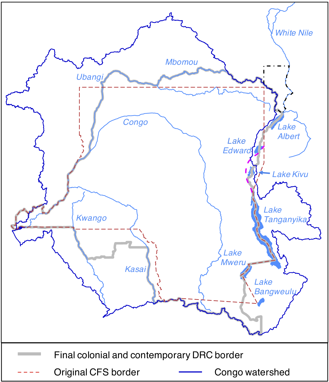
Figure 1. Evolving Borders of the Congo Free State
Note: For the arc near Lake Kivu (pink), see Supplementary Appendix C.5.9. For the Lado Enclave along the Nile (black), see Supplementary Appendix C.6.3.
Remarkably, even the Congo Free State largely supports our broader claim that Africa’s borders routinely incorporated relevant features on the ground. The decisions at the Conference and shortly afterward sketched a rough outline of the colony, but these borders were revised substantially in the following years and decades, as we illustrate in Figure 1. The original borders were, other than the Congo-river portions, primarily straight lines. Later, in the west and north, straight-line borders were revised to follow the Ubangi and Mbomou rivers.Footnote 10 In the east, the frontier north of Lake Tanganyika was shifted to Lake Kivu and the Ruzizi river, which corresponded with the western limits of the traditional Rwandan and Burundian states.Footnote 11 In the south, border revisions reflected the frontiers of the historical Lunda and Kazembe states.Footnote 12 Thus, local features mattered even in the supposedly paradigmatic case of arbitrary borders.
Beyond this single case, we provide novel evidence that most of Africa’s borders were not initially formed until after the 1884–85 Berlin Conference and that most did not take their final form until over two decades later. For all 107 bilateral borders in the final colonial map (c. 1960), we code the date of initial border formation and years of major revisions. A major revision constitutes transferring territory across colonies (either large tracts like entire provinces or smaller tracts like districts), adding a new segment to a border, or qualitatively changing the features of a border (e.g., replacing a straight line with a river).Footnote 13 We use this information in two ways. First, using bilateral borders as the unit of analysis in Figure 2, we track over time the cumulative fraction of the 107 borders that had been initially formed (red line) and that had undergone their final major revision (black). The median years for each are shown in dashed lines. Second, we digitized maps from the Cambridge History of Africa (Sanderson Reference Sanderson, Oliver and Sanderson1985) of formal European claims in Africa at different dates: 1887, 1895, and 1902. This enables us to compare earlier colonial borders to the final colonial borders circa 1960 as well as to assess how much territory Europeans had claimed at different points in time. In Figure 3, claimed territory is in gray. Using the detailed information we compiled for each border, we color segments of the boundaries shown in these maps either in black (indicating correspondence with a final colonial border) or red (not yet formed or later underwent major revisions).Footnote 14

Figure 2. Border Formation over Time in Africa
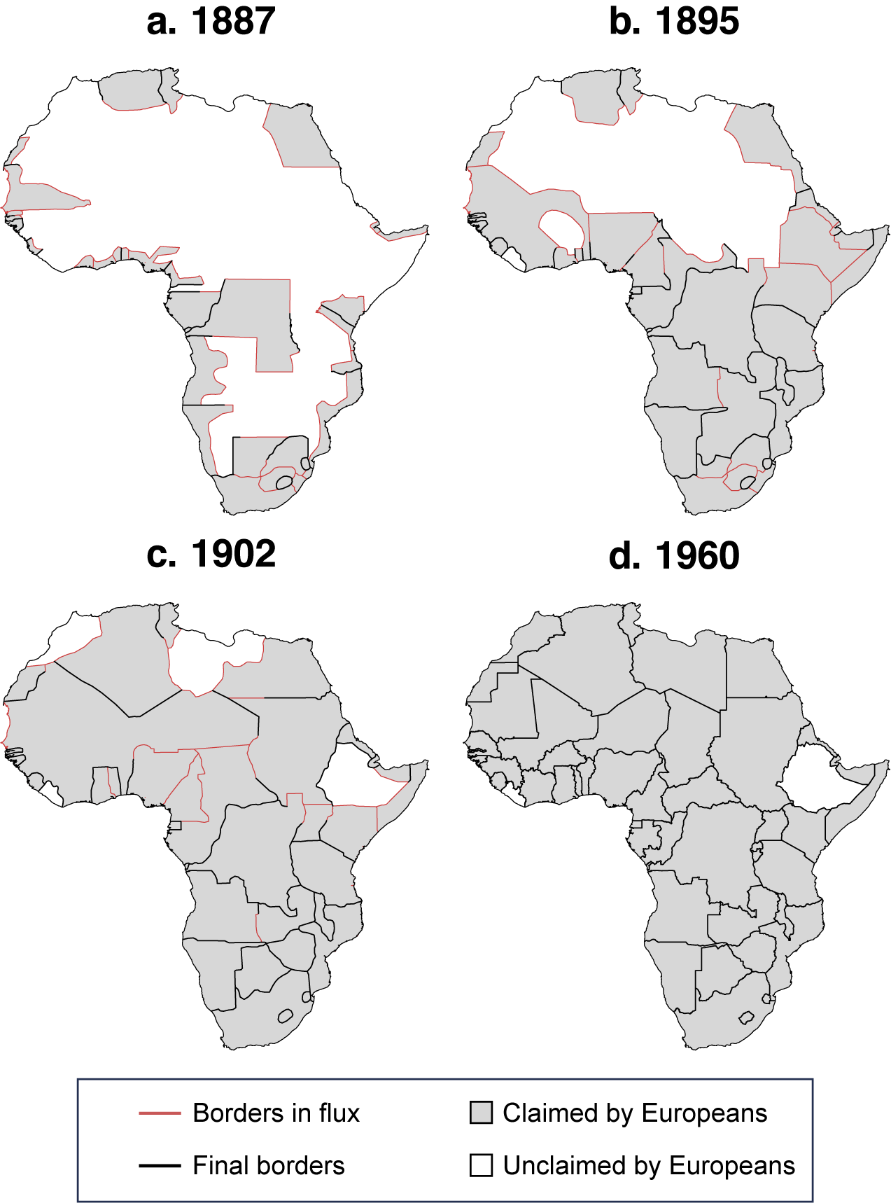
Figure 3. The Evolution of the European Political Map of Africa
As of 1887, the colonial map was highly preliminary (Figure 3a). A majority of coastal territory had been claimed (56% of territory within 300 km of the coast), but not the interior (22% of territory farther inland, and only 14% when excluding the Congo Free State). The border formation process had clearly taken shape at the macro level—that is, which European powers competed for territory in each broad region. Early trading posts influenced where borders would start at the coast (see Supplementary Figure A.2). However, borders were almost entirely undetermined at the meso level, which concerns the main features that roughly round out spheres of influence; let alone the micro level, the exact location and features of borders.Footnote 15 Overall, 31% of bilateral borders had been initially formed by 1887, but only 7% were in their final form (see Figure 2). One quarter of the initial borders were in southern Africa, where British and Boer settlers had intensively interacted with (and fought) Africans for a half century.Footnote 16 Taking the total length of African borders in 1960, only 18% was finalized by 1887.
Border-formation events accelerated shortly afterward (Figure 3b). Between 1889 and 1894, the major powers completed numerous bilateral treaties, such as the Anglo–French Agreement of 1889 (West Africa), the Anglo–German Agreement of 1890 (whole continent), and the Anglo–Portuguese Treaty of 1891 (southern Africa). These and other agreements allocated territory across most of the continental interior (meso level), excepting the Sahara, and formed at least preliminary bilateral borders throughout parts of the interior (micro level). At this point, Europeans claimed 83% of Africa’s coastal territory and 58% of the interior. Yet many borders were still in flux; when we examine border length, only 43% of all borders in 1960 were in place as of 1895. Among bilateral borders, 55% were initially formed and 25% were finalized.
By 1902, Europeans had claimed almost the entire continent (90% of interior territory), which finalized most macro- and meso-level components of border formation (Figure 3c).Footnote 17 Thus, the political map in broad strokes resembled its postcolonial form. However, nearly two decades after the Berlin Conference, the micro-level process of forming specific borders was still ongoing. Measured by border length, 39% of bilateral borders in 1960 had not been finalized by 1902. Among bilateral borders, 70% were initially formed and only 36% were finalized. In the twentieth century, twenty-one large territorial transfers occurred.Footnote 18 This included Anglo–French divisions of formerly German territory after World War I, various transfers to reward Italy’s participation on the Allied side in the war, several major transfers between Uganda and neighboring states, and territorial shuffling within the French empire. Other borders were revised in various ways in the twentieth century, including changing straight lines to local features (14 cases), adding new segments (13), or clarifying local features for previously ambiguous borders (19).Footnote 19
THEORY: THE PROCESS OF AFRICAN BORDER FORMATION
“It happened at Berlin” is not a compelling model of African border formation, nor is the broader idea that Europeans determined African borders from European capitals with minimal local knowledge. Yet other common contentions are correct. European statesmen had self-interested motives to claim territory while avoiding intra-European conflict in order to reduce the costs of imperial expansion (Christensen and Laitin Reference Christensen and Laitin2019, chap. 8; Herbst Reference Herbst2000, chap. 3). We present a new theory of African border formation to explain why these premises created incentives to draw borders conscientiously, rather than haphazardly. Our theoretical implications differ from the conventional characterization that Africa’s borders, for the most part, are arbitrarily designed (often straight lines), neglect local features, and indiscriminately partition historical states.
The Berlin Conference settled few borders and created only vague rules for “effective occupation” (see Supplementary Appendix A.1.2). A self-enforcing scheme for claiming territory and settling borders would need to enable European states to gain large tracts of territory that they deemed valuable while also minimizing the possibility of conflict. This created a classic coordination problem: within the set of divisions that all sides prefer to war, numerous conceivable borders were possible. Building upon previous research on IR border formation (Carter and Goemans Reference Carter and Goemans2011; Goemans Reference Goemans, Kahler and Walter2006; Simmons Reference Simmons2005), we argue that state diplomats frequently used focal points to draw borders and settle territorial disputes. Two local features appear countless times in historical accounts to serve as focal points, or focal frontier zones: historical political frontiers (mostly precolonial states) and major water bodies. To promote their territorial claims, Europeans gathered substantial intelligence about conditions on the ground through interactions with African rulers, which often facilitated African agency in negotiations.
Precolonial States and Historical Political Frontiers
Precolonial states served as important meso-level objects of contention—important features that roughly round out spheres of influence.Footnote 20 For centuries, Europeans had engaged in treaty-making with African rulers using documents that explicitly affirmed the sovereignty of the rulers with whom they contracted. This practice continued through the late nineteenth century; the main difference was that African rulers renounced sovereignty over external affairs in newer treaties. Because Europeans agreed that African rulers were legally sovereign, as opposed to treating their territory as unoccupied territorium nullius, Europeans considered bilateral treaties as necessary to provide legal justification for acquiring African territory (Alexandrowicz Reference Alexandrowicz and Ingham1973).
Consequently, treaties with local rulers were the agreed-upon currency to fill in the ambiguous rules of “effective occupation” laid out in Berlin, despite rarely corresponding with actual administrative occupation (Carpenter Reference Carpenter2012, 116; Wesseling Reference Wesseling1996, 127–8). These de facto rules prompted a rush in the 1880s to gain treaties with Africans in areas of strategic interest. Data from the British empire illustrate the frenetic pace of treaty signings. British agents engaged in some treaty-making with African rulers between 1808 and 1883, averaging 0.9 treaties per year. This activity spiked in the next decade, with an average of 59 treaties per year between 1884 and 1893.Footnote 21
Precolonial states served as ideal meso-level features for determining the approximate limits of a European power’s territorial claims. Securing treaties with rulers of sizable historical states yielded claims over large swaths of territory via the principle of suzerainty. A British official explicated this principle in a dispute with France in 1896 over what became the Benin–Nigeria border: “We could not abandon the principle of suzerainty. This principle was recognized in all international negotiations and we held that, in treating with a suzerain, the rights conferred […] extended to the whole of the territory under his dominion” (quoted in Anene Reference Anene1970, 220; see also Nugent Reference Nugent2019, 20). By contrast, where one ruler was found to be subordinate to another, a treaty with the subordinate ruler could be challenged for lacking territorial rights (Alexandrowicz Reference Alexandrowicz and Ingham1973, 141).
Capitalizing on the principle of suzerainty required self-interested European powers to gather intelligence about the frontiers of historical states and vassalage relations. Europeans were ignorant about on-the-ground realities in most parts of Africa upon convening the Berlin Conference. However, learning about local conditions thereafter enabled European powers to maximize their territorial claims—which were based, in part, on treaties with African rulers.
Gathering intelligence, in turn, necessitated continual interactions with local rulers and other Africans, such as translators. This facilitated African agency, a claim for which we provide extensive evidence later in the article and throughout the case studies in Supplementary Appendix C (see also the overview in Supplementary Appendix C.1.2). Local rulers strategically sought to preserve their territory. Likewise, to maximize their domains, Europeans favored claims by rulers with whom they signed treaties and contested those by others. This competitive process provided Europeans with detailed information about the domains of African rulers. Whereas competing European powers contested territorial claims based on fanciful descriptions of reality, they usually accepted territorial claims with unambiguous empirical backing—which depended upon continual interaction with African rulers. And, because few Europeans learned African languages, African translators were important in the process of information gathering and treaty-signing.
This process should yield two consequences. First, borders should not cut through areas governed by precolonial states. This would violate the principle of suzerainty, assuming one power had an unambiguous claim over the historical state and Europeans agreed upon its historical frontiers. As for intraimperial borders, more effective administration could be achieved by preserving a historical polity within a single colony.Footnote 22 Second, borders should often lie at the frontiers of historical states because a power’s claim ended there. Historical frontiers were rarely precise enough to create specific focal points, but nonetheless created useful “frontier zones.” Thus, we expect that Europeans took precolonial states into account not because of benevolent intentions, but instead because this meso-level feature provided a convenient bargaining chip to extend territorial claims while minimizing the risk of intra-European conflict.
By contrast, we anticipate that colonial borders might divide peoples in areas without major states, consistent with the existing literature. There, a European power would be hard-pressed to argue that treaties among loosely affiliated rulers constituted a basis for gaining control over an extended area (McGregor Reference McGregor2009, 57; Miles Reference Miles2014, 22–9). For example, although all the major Yoruba states were preserved within Nigeria on the basis of British treaties, the broader Yoruba cultural area was politically fractured, which enabled France to make credible claims in Western Yorubaland (Asiwaju Reference Asiwaju1976, 9). Consequently, although many ethnic groups in Africa were partitioned amid the Scramble (Asiwaju Reference Asiwaju1985; Miles Reference Miles2014), we anticipate that this process was not arbitrary or as-if random. Historical states were systematically different than areas lacking political unity.
Major Water Bodies
Access to major water bodies was another goal of European statesmen. Rivers could facilitate transportation and trade between the coast and the interior. Later, as Europeans became aware of inland lakes, they similarly sought access to facilitate trade. Major water bodies affected border formation at all three levels. At the macro level, major rivers that emptied into the ocean could entice European powers to compete over that general region, as we have already seen for the Congo. Water bodies could also comprise general areas of strategic interest (meso level) and/or be used as a specific feature of a border (micro level). Unlike precolonial states, multiple powers could access the same water body if their common border shared this feature. And, each power knew that others needed access to transportation hubs to make their colonies economically viable. Therefore, given the general desire to avoid intra-European conflict, we would usually expect them to yield to demands for access to the water bodies. Achieving this outcome was even simpler for intraimperial borders, as the same power controlled both sides. Although our strongest expectations are for longer rivers and larger lakes, less important rivers could serve similar purposes.Footnote 23
As with precolonial states, claims to water bodies were more effective when accompanied by knowledge of conditions on the ground. For example, the original border that separated the Congo Free State and German East Africa was a meridian line. In the mid-1890s, Germany realized that parts of Rwanda, a precolonial state, were located west of this meridian. It sought to revise the border to Lake Kivu (of which Europeans first became aware in 1894) and the Ruzizi river, which Germans had learned were the historical limits of the kingdom. “In the long run the German case proved the most forceful—natural and ethnic frontiers, so far as possible, should not be violated …The Germans and British claimed to uphold natural frontiers, but if they appear as champions on the side of Africans, it is at least in part because it was to their advantage to press the Congo State for natural boundaries” (Louis Reference Louis1963, 93–4).
Straight-Line Desert Borders
Some parts of Africa lacked clear focal points or frontiers, in particular deserts and other areas of low population density. Europeans should more frequently draw (and retain) artificial borders, often based on parallels and meridians, that disregard conditions on the ground in areas without focal features. However, the stakes of border placement were lower because the territory was rarely perceived as valuable. Therefore, although the exact placement of a straight-line border is typically arbitrary, the decision to draw a straight-line border should be conscious and strategic—and, consequently, relegated to areas with low population density.
QUANTITATIVE ANALYSIS OF BORDER LOCATION
We test our main theoretical implications with multiple forms of evidence. Quantitatively, using square grid cells, we assess whether precolonial states and geographic features predict African borders.
Variables
Precolonial States
We compiled new spatial data on precolonial states. Ajayi and Crowder’s (Reference Ajayi and Crowder1985) Historical Atlas of Africa provides the most extensive and detailed maps of which we are aware containing the territorial location of precolonial polities on the eve of European colonization. The atlas contains seven detailed regional maps for the nineteenth century, each of which is produced by a leading scholar on a particular region of Africa.
We do not classify every polygon in Ajayi and Crowder (Reference Ajayi and Crowder1985) as a precolonial state. As discussed in Supplementary Appendix B.1, we consulted additional sources to assess which candidate cases meet Fortes and Evans-Pritchard’s (Reference Fortes and Evans-Pritchard1940, 5) criteria for Group A societies, meaning they have “centralized authority, administrative machinery, and judicial institutions—in short, a government.” This distinguishes cases in which a polity had a ruler whose political authority extended over a broader area corresponding with the territory in Ajayi and Crowder’s (Reference Ajayi and Crowder1985) maps. This contrasts with small-scale chieftaincies (e.g., highly geographically circumscribed); the numerous types of decentralized entities that pervaded precolonial Africa such as village councils, age-grade societies, and kinship groups (Vansina Reference Vansina1990); and non-independent polities. We consulted three sources that provide a continent-wide list of states in the nineteenth century: Stewart (Reference Stewart2006), Paine (Reference Paine2019), and Butcher and Griffiths (Reference Butcher and Griffiths2020).Footnote 24 Some cases are unambiguous because all three sources identify the polity as a state. For cases with disagreement among the three, we consulted additional sources. Finally, we restrict the sample to states that originated before 1850 to reduce concerns about colonial penetration influencing PCS boundaries.
For all 46 polities we classified as a precolonial state, we consulted Ajayi and Crowder’s (Reference Ajayi and Crowder1985) atlas and at least one historical monograph with a map and qualitative description of historical boundaries. We usually digitized a polygon from Ajayi and Crowder (Reference Ajayi and Crowder1985), but sometimes used a more precise alternative map. The maps and polygons capture African states on the eve of colonization, usually from around 1885. However, in cases of earlier colonial penetration (e.g., Senegal and South Africa), we use polygons from the mid-nineteenth century.
Figure 4 depicts every precolonial state in our dataset and Supplementary Appendix B.2 provides extensive supporting evidence for each polygon. African states generally had meaningful territorial limits, at least in the sense of discernible frontier zones, although measurement error is inevitable because of often-shifting territorial control throughout the nineteenth century and the general imprecision of frontier areas. Consequently, we perform a robustness check in which we thicken the frontier by creating a 0.25o buffer on each side of a precolonial state border (thus 0.5o in total).
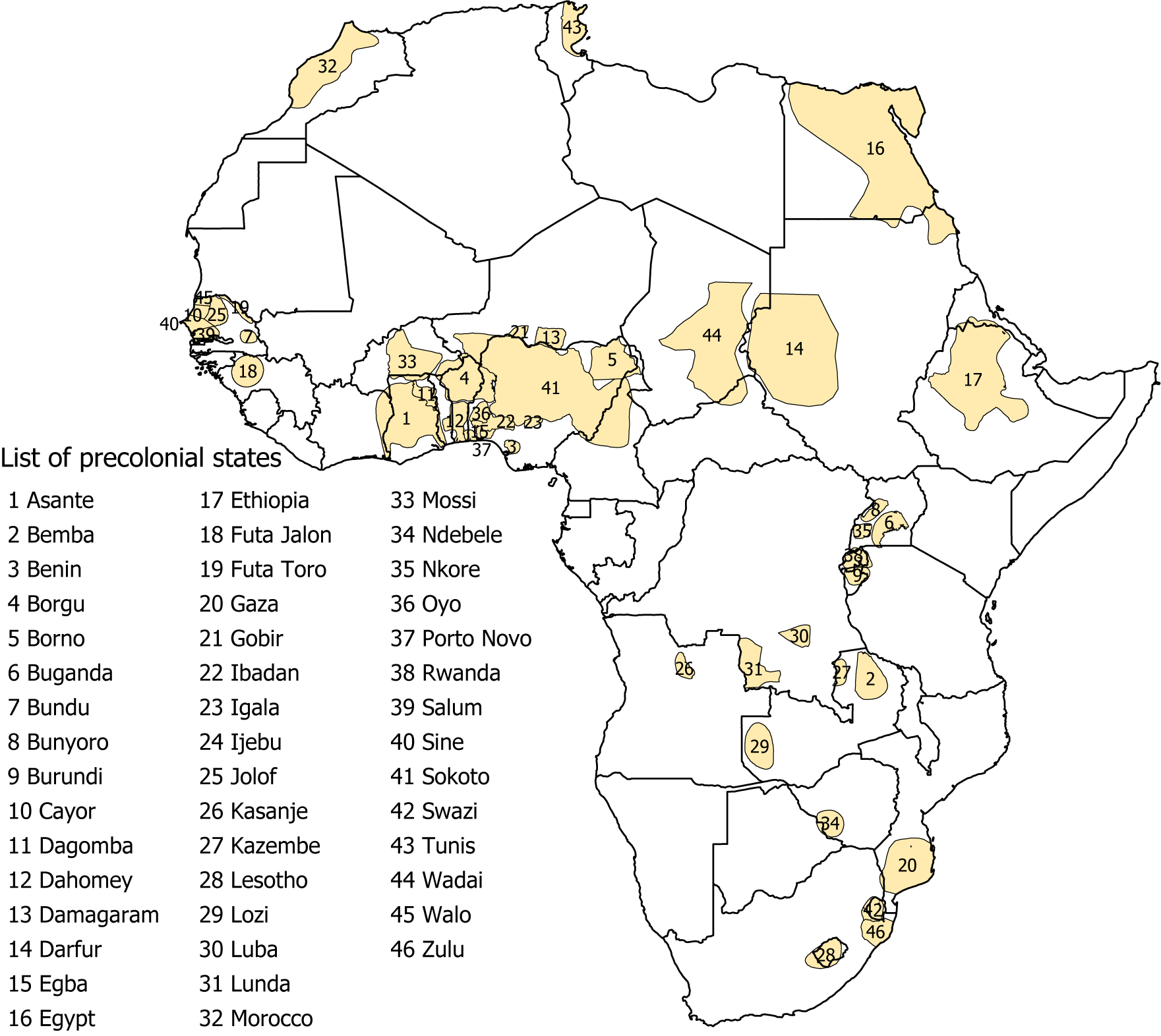
Figure 4. Map of Precolonial States and Boundaries
Note: The map visualizes our dataset of African precolonial states and their boundaries, with 1960 boundaries superimposed.
Water Bodies, Watersheds, and Deserts
We examine specifications with all rivers and with rivers disaggregated into major (top 10 longest in Africa) and minor (all other rivers); and the same for lakes. We also assess major watersheds as derivatives of water bodies. Finally, we examine desert areas. Supplementary Appendix A.2.1 provides the sources for each variable.
International Borders
We use international borders around the time of independence (1960) and exclude post-independence border changes.Footnote 25 Colonizers regularly readjusted the borders (see Supplementary Figure A.1). We capture the end result of this protracted process. Furthermore, for many research questions, the final colonial map is most relevant for studying postcolonial legacies.
Unit of Analysis: Grid Cells
The unit of analysis is grid cell. Each cell is 0.5×0.5 decimal degrees (approximately 55 km at the equator), following standard practice (Kitamura and Lagerlöf Reference Kitamura and Lagerlöf2020; Tollefsen, Strand, and Buhaug Reference Tollefsen, Strand and Buhaug2012). This procedure yields slightly over 10,000 grid cells across the continent (excluding islands). To score the variables for each grid cell, we combine the spatial data described above with the grid cells. Most are indicator variables, for example, whether a cell includes a river segment. Grid cells enable us to be agnostic about the appropriate comparison group for precolonial states (PCSs), as peoples living in decentralized communities usually lacked clear territorial limits.Footnote 26 Along with the exercise of thickening PCS borders, grid cells also make our results robust to some degree of measurement error in PCS borders.
We partition the grid cells by whether each (a) contains the edge of a PCS polygon (pcs frontier $ =1 $
), (b) lies entirely within a PCS polygon (pcs interior
$ =1 $
), (b) lies entirely within a PCS polygon (pcs interior $ =1 $
), or (c) does not contain any part of a PCS polygon (pcs frontier
$ =1 $
), or (c) does not contain any part of a PCS polygon (pcs frontier $ = $
pcs interior
$ = $
pcs interior $ =0 $
). Figure 5 uses the Nigeria–Niger border to visualize how we code grid cells.
$ =0 $
). Figure 5 uses the Nigeria–Niger border to visualize how we code grid cells.

Figure 5. Niger–Nigeria Border with Overlaid 0.5o x 0.5o Grid Cells
Note: The map shows parts of the Niger–Nigeria border (and small segments of their respective borders with Benin) in black (dependent variable), precolonial states in orange (explanatory variable), and grid lines in gray (unit of analysis). The letters provide examples of cells with different values of the variables; Cell A: dv $ =1 $
; Cell B: pcs frontier
$ =1 $
; Cell B: pcs frontier $ =1 $
; Cells C and D: dv
$ =1 $
; Cells C and D: dv $ =1 $
and pcs frontier
$ =1 $
and pcs frontier $ =1 $
; Cells A and E: pcs interior
$ =1 $
; Cells A and E: pcs interior $ =1 $
.
$ =1 $
.
Regression Results
For the grid-cell analysis, we specify our hypotheses as follows:
-
1. PCS frontier cells should more frequently have country borders than other cells (either PCS interior or non-PCS cells).
-
2. PCS interior cells should less frequently have country borders than other cells (either PCS frontier or non-PCS cells).
-
3. Cells with either rivers or lakes should more frequently have country borders than other cells.
To assess these hypotheses, we estimate the following models using OLS:
 $$ \begin{array}{c}{\mathrm{Border}}_i={\beta}_0+{\beta}_1{\mathrm{Geog}}_i+{\epsilon}_i,\end{array} $$
 $$ \begin{array}{rl}{\mathrm{Border}}_i={\beta}_0+{\beta}_1{\mathrm{PCS}}_i+{\mathrm{Geog}}_i^T{\beta}_2+{\mathrm{X}}_i^T{\beta}_3+{\eta}_j+{\epsilon}_i.& \end{array} $$
In every regression, the dependent variable indicates whether a cell i contains part of a country border. We use Conley standard errors (Conley Reference Conley1999; Hsiang Reference Hsiang2010) to account for spatial dependence. We use a distance cutoff of 300 km (approximately six grid cells at the equator) in our main results, although the findings are robust to altering the cutoff.Footnote 27 The beginning of Supplementary Appendix A.2 summarizes every robustness check in the appendix.
In our main specifications, we use bivariate models to assess each geographic feature. We purposely do not control for post-treatment variables such as the existence of a precolonial state. However, we show in Supplementary Tables A.4 and A.5 that the results in Figure 6 are robust to their inclusion and to including multiple geographic variables in the same model.

Figure 6. Correlates of African Borders
Note: The figure summarizes coefficient estimates and confidence intervals at the 95% and 90% levels for the main explanatory variables. Supplementary Tables A.4 and A.5 present complete results. $ N=\mathrm{10,341} $
for the full sample and
$ N=\mathrm{10,341} $
for the full sample and $ N=\mathrm{7,135} $
for the Sub-Saharan Africa (SSA) sub-sample. Controlling for agricultural intensity in the bottom panel causes observations to drop to
$ N=\mathrm{7,135} $
for the Sub-Saharan Africa (SSA) sub-sample. Controlling for agricultural intensity in the bottom panel causes observations to drop to $ \mathrm{9,913} $
in the full sample and
$ \mathrm{9,913} $
in the full sample and $ \mathrm{6,816} $
for SSA. The geography models do not contain any covariates. Most are bivariate, although major/minor rivers and major/minor lakes are each included in the same specification. Every model in the lower part controls for geography (variables in the top part) plus the aforementioned covariates.
$ \mathrm{6,816} $
for SSA. The geography models do not contain any covariates. Most are bivariate, although major/minor rivers and major/minor lakes are each included in the same specification. Every model in the lower part controls for geography (variables in the top part) plus the aforementioned covariates.
We estimate multivariate models for each PCS indicator, PCS frontier and PCS interior.Footnote 28 To guard against potential omitted variable basis, we include a vector of the aforementioned geographic factors as covariates. We also add a vector of variables ( $ {\mathrm{X}}_i $
) to control for other factors that might have affected colonizers’ propensity to draw borders in the area. One is an originally coded variable for areas located between precolonial trading posts or natural harbors that were claimed by different powers, extended up to 300 km in the interior (see Supplementary Figure A.2). Such areas are more likely to contain a colonial border (confirmed in Supplementary Table A.5), given the need to separate competing European claims. Other covariates account for various other confounding concerns, such as geography (latitude, longitude, and distance to the coast), climate (suitability for European settlement, tsetse fly suitability), historical natural resources, and various measures of historical ethnic geography (size of the ethnic group in cell, ethnic group border in cell,Footnote 29 ecological diversity of the ethnic group in cell, population density in 1850, historical slave exports, and agricultural intensity).Footnote 30 We also include region fixed effects (
$ {\mathrm{X}}_i $
) to control for other factors that might have affected colonizers’ propensity to draw borders in the area. One is an originally coded variable for areas located between precolonial trading posts or natural harbors that were claimed by different powers, extended up to 300 km in the interior (see Supplementary Figure A.2). Such areas are more likely to contain a colonial border (confirmed in Supplementary Table A.5), given the need to separate competing European claims. Other covariates account for various other confounding concerns, such as geography (latitude, longitude, and distance to the coast), climate (suitability for European settlement, tsetse fly suitability), historical natural resources, and various measures of historical ethnic geography (size of the ethnic group in cell, ethnic group border in cell,Footnote 29 ecological diversity of the ethnic group in cell, population density in 1850, historical slave exports, and agricultural intensity).Footnote 30 We also include region fixed effects ( $ {\eta}_j $
) to account for unobservables common to units in the same region.Footnote 31
$ {\eta}_j $
) to account for unobservables common to units in the same region.Footnote 31
We summarize the regression estimates with a coefficient plot in Figure 6. The top part validates our third hypothesis: across different measures of rivers and lakes, areas with major water bodies are more likely to have a nearby country border. The coefficient estimates are particularly large in magnitude for the longest rivers and largest lakes. The presence of a top 10 river in a cell increases the predicted probability that a border will exist in that cell from 14.2% to 31.3%, a 121% increase. For top 10 lakes, the probability increases from 14.4% to 50.0%, a 244% increase. Desert areas are less likely to have a country border, which reflects the typically large size of colonies in thinly populated areas (Green Reference Green2012).
The bottom part of Figure 6 supports our first and second hypotheses: PCS frontier cells are more likely to contain country borders, whereas PCS interior cells are less likely to contain country borders. Holding other variables at their means, a PCS frontier in the cell raises the predicted probability of a country border from 14.2% to 23.8%, a 68% increase. For PCS interior cells, the predicted probability decreases from 16.0% to 6.6%, a 59% decline.
Figure 6 also presents various robustness checks for the PCS variables. We restrict the sample to Sub-Saharan Africa (SSA; cells south of $ {18}^{\circ}\mathrm{N} $
) and create a
$ {18}^{\circ}\mathrm{N} $
) and create a $ {0.25}^{\circ } $
buffer on each side of PCS borders. The findings are qualitatively unchanged and the coefficients increase in magnitude for the SSA sub-sample, which excludes large Saharan areas of lower European interest. In addition to controlling for multiple covariates, we formally assess the sensitivity of our findings to unobserved covariates by estimating Oster bounds, which show our results are very robust to potential omitted variables (Supplementary Appendix A.2.5).
$ {0.25}^{\circ } $
buffer on each side of PCS borders. The findings are qualitatively unchanged and the coefficients increase in magnitude for the SSA sub-sample, which excludes large Saharan areas of lower European interest. In addition to controlling for multiple covariates, we formally assess the sensitivity of our findings to unobserved covariates by estimating Oster bounds, which show our results are very robust to potential omitted variables (Supplementary Appendix A.2.5).
QUALITATIVE EVIDENCE FOR BILATERAL BORDERS
The regression evidence demonstrates that precolonial states and water bodies are systematically correlated with border location. In this section, we analyze qualitative evidence for all 107 bilateral borders in Africa, achieving two goals. First, our theory contains several implications about mechanisms that cannot be tested with correlational evidence alone. For the process of border formation, we expect that (a) precolonial states and water bodies were of intense strategic interest as meso-level objects,Footnote 32 (b) Europeans actively collected information about conditions on the ground, and (c) African agency affected the process. Second, our theoretical expectations are incompatible with existing assertions that the overwhelming majority of Africa’s borders consist of straight lines. Consequently, we present new evidence about the physical features of African borders. Combined with the data on major border revisions, described earlier, these originally coded data for each bilateral border substantially revise our understanding of Africa’s borders.
We compiled extensive qualitative evidence to support our claims, only a fraction of which we can present in the main text. In Supplementary Appendix C.1.1, we provide more detailed coding rules. In Supplementary Appendix C.1.2, we briefly summarize all 29 precolonial states coded as directly affecting at least one bilateral border. The remainder of Supplementary Appendix C provides over one hundred pages of notes to justify our coding decisions. The beginning of the section for each geographical region provides an overview of the main macro- and meso-level factors that influenced borders, while also highlighting the clearest examples in which African agency affected border formation.
Precolonial States and Historical Political Frontiers
The present consensus is that existing political realities played little to no role in the partition of Africa. By contrast, we find that a historical political frontier directly affected 66 of 107 bilateral borders (62%). Of these 66 cases, 47 involved at least one precolonial state from our quantitative dataset. The remaining cases were based on historical political frontiers created by white settlements and states, in particular in southern Africa; non-European states such as Ottoman territories in the north and the resettlement colony of Liberia; and several decentralized groups, often nomadic groups whose grazing areas were used to determine intraimperial borders in areas of low population density (see Supplementary Table C.2).
These findings are based on causal process observations that assess, for each bilateral border, whether a historical political frontier directly affected the border’s location. Coding a direct effect requires us to find evidence that Europeans deliberately set a border in an area known to correspond with a particular historical political frontier. We make this assessment by consulting treaties and internal colonial documents (drawing mainly from Hertslet Reference Hertslet1909 and Brownlie Reference Brownlie1979) and over one hundred diplomatic histories and other historical accounts. These sources provide rich information about Europeans’ interactions with Africans to learn about historical frontiers, and how they used this information in interimperial negotiations and intraimperial administrative decisions.
Europeans sometimes used the frontiers of precolonial states to draw borders, without disputing those frontiers. These were usually predicated upon a treaty between European agents and a local ruler, as with the Bayol treaty that France secured with Futa Jalon in 1881.Footnote 33 France’s subsequent border agreement with Portugal stated, “Art. II.—His Majesty the King of Portugal and Algarves recognizes the French Protectorate over the territories of Fouta-Djallon …” (quoted in Hertslet Reference Hertslet1909, 674). Consequently, the Bayol treaty became a foundation for France’s claims despite minimal effective presence in Futa Jalon (Carpenter Reference Carpenter2012, 117), which it did not defeat militarily until 1896.
In many other cases, Europeans engaged in lengthy disputes about the limits of historical states; one European power used African-signed treaties to make expansive territorial claims, which another power challenged. For example, Britain and France contested the limits of the Sokoto Caliphate when determining what became the border between Nigeria and Niger, yielding several major revisions (Figure 7a). Amid northward expansion from the Niger Delta, British agents from the Royal Niger Company gained a treaty with the Caliph of Sokoto in 1885 (Hertslet Reference Hertslet1909, 122–3). France accepted British suzerainty over Sokoto in an 1890 treaty, which stated that Britain would gain all the territory “that fairly belongs to the Kingdom of Sokoto” (quoted in Hertslet Reference Hertslet1909, 739). Reflecting limited knowledge, the powers drew a straight-line border, connecting points on the Niger River and Lake Chad.
As the powers collected more intelligence about local conditions, France sought to revise the line southward to gain territory north of Sokoto’s historical frontiers—a contention with historical grounding. Throughout the nineteenth century, flag bearers from the Caliphate conquered traditional Hausa states and established Fulani-ruled emirates, prompting some Hausa dynasties to flee. For example, Sokoto flag bearers conquered Katsina, which became the capital of the Katsina emirate, and the Hausa ruling family relocated north to Maradi (see our map) and preserved its independence through persistent warfare. Other states, such as Damagaram centered at Zinder (also in our figure), formed later in the nineteenth century and were independent of Sokoto.
Britain and France established the broad contours of the present-day Nigeria–Niger border in 1904, following an earlier revision in 1898 that reflected their continued ignorance about the area. France sought to gain a route through inhabited territories that would connect its various possessions, as opposed to the desert territory conceded in earlier agreements. This created an incentive for France to leverage new intelligence it had collected about the area and to bargain for control over polities that lay beyond Sokoto’s sphere. Consequently, the new border replaced arbitrary lines with a delimitation based precisely on the location of different towns and the roads used to connect them. The 1904 treaty stated the need for a line that incorporated “recognized and well-established frontiers,” with specific stipulations that “the tribes belonging to the territories of Tessaoua-Maradi and Zinder shall, as far as possible, be left to France” (quoted in Hertslet Reference Hertslet1909, 819); and one component of the border description was “a direct line to a point 15 kilometres south of Maradi …” (818).Footnote 34
African actors were more directly involved in other cases. In what became the Chad–Sudan border, Britain and France disputed the limits of the historical states of Darfur and Wadai, after explicitly specifying these historical states as features of their interimperial boundary in 1899. The final settlement was delayed because the Sultan of Darfur retained his army and fought the French to enforce expansive claims about the limits to his frontier. The powers did not settle the border until 1919, after Britain deposed the sultan, which resulted in the powers dividing various disputed petty sultanates across their spheres (Figure 7b).Footnote 35

Figure 7. Examples of Borders Shaped by Precolonial States
Note: Polygons for precolonial states from authors’ digitization (sources listed in Supplementary Appendix B.2). Supplementary Appendix A.2.1 lists the sources for rivers, lakes, and final colonial borders. (a) Provisional colonial borders from authors’ digitization of Brownlie (Reference Brownlie1979, 446). (b) Decentralized groups from authors’ digitization of Theobald (Reference Theobald1965, 53). (c) Provisional 1922 border from authors’ digitization of McEwen (Reference McEwen1971, 152). (d) Provisional colonial border from authors’ digitization of Brownlie (Reference Brownlie1979, 250), and Ewe shapefile from Murdock (Reference Brownlie1959).
African agency sometimes prompted revisions of earlier partitions. Other powers seized upon Germany’s defeat in World War I to partition its colonies, which created opportunities for African lobbying. German East Africa was divided into two Mandate territories: Belgian Ruanda-Urundi and British Tanganyika. The division originally proposed in 1922 severed a region, Gisaka, that had historically belonged to Rwanda, to facilitate Britain’s Cape-to-Cairo railroad. In response, “an alliance between Musinga [the Rwandan ruler], the Belgians and the Catholic Church (especially Cardinal Classe) defended the re-annexation of Gisaka to Rwanda” (Mathys Reference Mathys2014, 155). They “emphasize[d] the social, political, and economic harm caused by the imposition of this arbitrary division and they urge[d] the eastward extension of the boundary to the ‘natural frontier’ of the Kagera River” (McEwen Reference McEwen1971, 154–5). When the League of Nations’ Permanent Mandates Commission reviewed the claims, they highlighted that the agreement separated “one of the richest and most civilised tracts of the Kingdom of Ruanda” and decried the “‘deplorable moral effect’ that the present arrangement had on the local population and their strong protests” (McEwen Reference McEwen1971, 154–5). British and Belgian officials responded by altering the boundary to follow the Kagera River (Figure 7c).Footnote 36 In Dagomba, a petition by its traditional ruler stimulated Britain to include its historical frontiers within the newly acquired British Togoland, which joined Ghana at independence. This reversed the earlier division of Dagomba between British and German territories (Figure 7d).Footnote 37 The powers also discussed revising the segment of the border that partitioned the Ewe cultural area, but decided against doing so because the decentralized Ewe lacked discernible political frontiers.
Ethiopia is the starkest example in which African agency affected borders, which also involved revising an earlier partition. This was the sole case in which an African precolonial state retained its independence for (almost) the entire colonial period. Ethiopia was originally allocated to the Italian sphere of influence, and Europeans ignored the expansive territorial claims Emperor Menelik II made in 1891. However, Ethiopia militarily defeated Italy in 1896. Consequently, Italy, Britain, and France acknowledged Ethiopia’s independence, and Menelik gained substantial amounts of disputed territory in a series of bilateral treaties.Footnote 38 Nor was Ethiopia the only case in which Europeans directly negotiated with an African ruler over colonial borders, which also occurred in Buganda,Footnote 39 Lesotho,Footnote 40 and Swaziland.Footnote 41
Physical Features of Borders: Water Bodies and Straight Lines
Summary of All Borders
We coded the physical features of every bilateral border. The broad categories are water bodies, other local features, and straight lines; and each is disaggregated into different types.Footnote 42 For each bilateral border, we identify one or two features that are primary by constituting the plurality (and usually the majority) of the length of the border. Secondary features comprise smaller segments. Table 1 summarizes the frequency of each feature.
Table 1. Features of African Bilateral Borders

Note: In addition to rivers proper, “Any river” also includes streams and oueds (although these derivatives of rivers are rarely used in borders). “Other water bodies” include wells, oases, and water holes. “Topography” is mainly mountains, but also hills, valleys, plateaus, passes, rock formations, and dunes. “Infrastructure” is mainly roads, but also caravan routes and forts. We count short segments of straight-line borders that connect local features, which biases in favor of counting straight lines as secondary features. The sum of primary features for the main categories exceeds 100% because some borders are coded as having two co-primary features (e.g., a river and a straight line).
In 63% of Africa’s bilateral borders, water bodies (rivers and lakes) or their watersheds comprise the primary feature. Few borders (8%) lack water bodies entirely as a feature. Major water bodies are an important component of these percentages because they are the primary feature of 23% of all borders and are used in some form in 37% of all borders. Although numerous borders comprised primarily of water bodies were also directly affected by a precolonial state (31 cases), even more were not (36 cases). This summarizes what can be gleaned from studying individual cases: water bodies sometimes formed the limits of historical states and became colonial borders for that reason, but sometimes were used on their own.
Straight lines are the primary feature of 37% of bilateral borders, with a total of 18% for latitude/longitude lines and 20% for non-astronomical straight lines. These percentages, although not trivial, are appreciably smaller than commonly cited statistics, which overstate the degree to which straight lines were used in African borders. Barbour (Reference Barbour, Barbour and Prothero1961, 305) asserts that 44% of African borders are parallel/meridian lines, 30% are mathematical (i.e., non-astronomical) lines, and 26% are relief features.Footnote 43 Barbour bases his calculations solely on information from Hertslet (Reference Hertslet1909), thereby ignoring the many major border revisions that happened subsequently (see Figure 2 and Supplementary Figure A.1); and explicitly qualifies his calculations as “very approximate.” Our summary statistics, based on rigorous definitions and extensive supporting information, more accurately account for the features of Africa’s bilateral borders.Footnote 44
Straight lines not only comprise the primary feature of a lower fraction of bilateral borders than commonly claimed, but the location of straight-line borders is highly correlated with desert areas. Desert territories have low population density, fewer local features to use in the borders, and were of lesser strategic interest to Europeans. Among the 27 borders located largely within deserts, straight lines are the primary feature of 78%, compared to 24% for the 80 non-desert borders. The corresponding figures are 41% and 10% for borders comprised specifically of parallel/meridian lines.Footnote 45
Non-astronomical straight-line borders, unlike parallels/meridians, are usually specified in relation to local features. Outside desert areas, every bilateral border for which the primary feature is non-astronomical straight lines incorporated at least one local feature. These include minor rivers, towns, and roads as secondary elements. Thus, many straight-line segments of borders cannot be treated as entirely arbitrary in their precise location. Even some straight-line Saharan borders hide conscientious design. Boilley (Reference Boilley2019, 7–8) argues that “the [French] colonial logic [in the Sahel] was to preserve the old limits in order to manage the conquered territories more easily […] Lines replaced zones, but these zones were effectively old borders.” For example, Mali’s borders with each of Algeria and Niger are mostly straight, but these lines were deliberately placed to encompass distinct Tuareg subgroups within a single colony.Footnote 46
Interpreting Water-Body Borders
Our findings for water bodies clearly defy a strong version of the arbitrary borders thesis. If Europeans systematically incorporated local features, then the borders are not as-if random. However, our expectation also defies a weaker version of the arbitrary borders thesis. Major water bodies were important macro- and meso-level objects of strategic interest, as opposed to purely micro-level markers; and borders following rivers or lakes are, typically, not orthogonal to human experiences on the ground.Footnote 47
Europeans competed for access to water bodies across the continent. Competition over the Congo River spurred the Berlin Conference, as discussed earlier. France and Britain alternated possessions at the mouth of the Senegal and Gambia rivers, respectively.Footnote 48 The British South Africa Company deliberately split its possessions (which became Southern Rhodesia/Zimbabwe and Northern Rhodesia/Zambia) along the Zambezi;Footnote 49 and farther west, Germany’s desire to access the Zambezi resulted in the geographically absurd Caprivi Strip.Footnote 50
Rivers sometimes affected macro- and meso-level claims even when they did not, ultimately, become a micro-level border feature. Among the major rivers, the two least important for borders are the Nile (only its watershed is a primary feature of any border) and the Niger (used only for the short intraimperial Benin–Niger border). Yet these “null” cases in fact reflected a systematic process—British interests in controlling both rivers were strong enough to risk war with France to uphold its exclusive claims. In the 1890s, Britain granted leases along the Nile river to the Congo Free State and supported Italy’s early claims to Ethiopia, mainly to create buffers against French encroachment on the Nile.Footnote 51 This competition ended with British and French military units meeting at Fashoda in 1898.Footnote 52 Earlier, in the 1880s and 1890s, France challenged Britain’s supremacy on the Niger, which almost resulted in war when France occupied Bussa in 1898.Footnote 53
Later, as Europeans gained awareness of inland lakes, they similarly sought access to facilitate trade. For example, Cecil Rhodes, moving northward from southern Africa, strove “to gain access to Lake Tanganyika, the great waterway to the north” (Roberts Reference Roberts1976, 157).Footnote 54 Britain also sought access to Lake Tanganyika from the north by extending their domains south of Uganda.Footnote 55 In 1894, they secured a treaty with King Leopold that contained a provision for Britain to gain a thin strip of territory between the Congo Free State and German East Africa connected to the lake, which would facilitate an “all-red route” from Cape to (eventually) Cairo. However, German opposition convinced Britain to withdraw this provision of the treaty. Later that decade, Germany began pressuring the Congo Free State to shift their mutual border eastward to incorporate Lake Kivu, the traditional limit of the Rwandan state.Footnote 56 As another example, Britain issued an ultimatum to Portugal in 1890 to cease military operations in areas including the Shire Highlands and Lake Malawi, where British missionaries had established posts.Footnote 57
Nor is choosing borders that follow rivers or lakes orthogonal to Africans’ experiences on the ground (Reid Reference Reid2012, 2–3). In the Great Lakes region (see Figure 8), economic transformation through farming and agriculture in the region’s fertile forests began centuries ago because of favorable altitudes, adequate rainfall, and water bodies (Curtin et al. Reference Curtin, Feierman, Thompson and Vansina1995, 107, 132). Lake Victoria was “crisscrossed by a network of trade ties” (370), and the most important nod in the network was arguably the Kingdom of Buganda. Reid (Reference Reid2002, 227) discusses “the enormous significance of Buganda’s lakeside location,” including the invention of sophisticated canoes in the nineteenth century to foster trade and, with it, economic and political development. As Figure 8 shows, every major historical state in the region clustered around a Great Lake. The consequent colonial borders (albeit after numerous revisions) reflected the geography and the political economy of the region. In some cases, water-body borders also incorporated the frontiers of precolonial states, whereas elsewhere (Lakes Tanganyika, Malawi, and Mweru) they were used independently of precolonial states. Rivers and lakes also shaped the precolonial development of peoples with decentralized institutions, including where they settled and the trade patterns among them. Population settlements in western Equatorial Africa, for example, corresponded neatly with rivers and vegetation zones in the precolonial period (Curtin et al. Reference Curtin, Feierman, Thompson and Vansina1995, 217).
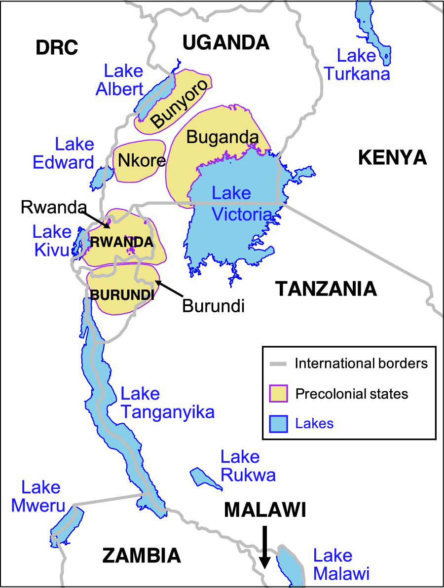
Figure 8. Borders in the Great Lakes Region
Note: Polygons for precolonial states from authors’ digitization (sources listed in Supplementary Appendix B.2). Supplementary Appendix A.2.1 lists the sources for lakes and international borders.
The ways in which water bodies affect human and political development in the long run are complex and variegated. In the Great Lakes region, water-body borders typically united historical states, whereas elsewhere they sometimes divided groups with cultural similarities.Footnote 58 But in either case, important water bodies are not orthogonal to social realities on the ground. In East Africa, creating new, large colonial states was undoubtedly artificial relative to precolonial precedents. However, the borders themselves are anything but arbitrary.
CONCLUSION
According to conventional wisdom, European statesmen drew African borders in ignorance of local conditions, exemplified by the Berlin Conference of 1884–85. This resulted in arbitrarily located borders. We overturn this convention. Most African borders were not in fact settled for decades after the Berlin Conference, during which time Europeans gathered extensive information about conditions on the ground. We provide an alternative theory to explain why precolonial states and water bodies were focal for determining borders. Quantitatively, we use original spatial data on precolonial states and estimate regressions using grid cells to demonstrate that these local features correlate with border location. Qualitatively, historical political frontiers directly affected 62% of bilateral borders. In many cases, Europeans learned about and intensively debated the limits of precolonial states, among themselves and also with African rulers, which facilitated an underappreciated role for African agency. Europeans also frequently revised initial borders to reflect local realities. Water bodies, often major ones, comprised the primary border feature much more frequently than straight lines, which are mostly confined to desert areas.
The idea that Africa’s international borders are unusually arbitrary is foundational. As Boilley (Reference Boilley2019, 5) puts it, “The cliché of Berlin has endured, in spite of efforts of historians to destroy it.” Our article provides a coherent alternative theory of border formation in Africa with strong empirical backing that should help destroy that cliché. We contribute to a new understanding of how modern-day countries were created in Africa. The resultant political map has subsequently influenced domestic and international political institutions. Here, we discuss three broader implications of our findings.
First, we raise important questions about the growing research agenda that exploits as-if randomness in African borders for regression discontinuities and related research designs (McCauley and Posner Reference McCauley and Posner2015 review this literature). We heed Kocher and Monteiro’s (Reference Kocher and Monteiro2016, 952) call that “qualitative historical knowledge is essential for validating natural experiments.” Dunning (Reference Dunning2012) discusses the relevance of what policymakers know when choosing a certain policy; greater knowledge makes claims of as-if randomness less credible. Although we do not question the findings of any particular study, we caution against generally characterizing Africa’s borders as arbitrary. Over half of all African bilateral borders experienced a major revision in the twentieth century, when European knowledge of the continent was far greater than during the 1884–85 Berlin Conference. For cases in which a particular feature (e.g., river) was chosen over another without much justification, a claim of conditional randomness may be justified. But making such an assessment requires consulting the history and features of the borders. We do so for every bilateral border in Supplementary Appendix C, which we hope will advance this important research agenda.
Second, many scholars examine how precolonial states affected the directness of colonial rule (Gerring et al. Reference Gerring, Ziblatt, Van Gorp and Arévalo2011; Letsa and Wilfahrt Reference Letsa and Wilfahrt2020; Müller-Crepon Reference Müller-Crepon2020). Colonialism is a key intervening period in related studies of the long-term consequences of precolonial states for outcomes such as economic development (Dasgupta and Johnson-Kanu Reference Dasgupta and Johnson-Kanu2021; Michalopoulos and Papaioannou Reference Michalopoulos and Papaioannou2013), civil war (Paine Reference Paine2019; Wig Reference Wig2016), and democracy (Baldwin Reference Baldwin2016; Neupert-Wentz, Kromrey, and Bayer Reference Neupert-Wentz, Kromrey and Bayer2022). By showing that colonial borders largely preserved, rather than dismembered precolonial states, we can better account for their persistence in shaping colonial governance (indirect rule) and postcolonial outcomes. Furthermore, our new georeferenced dataset of African precolonial states should be a useful resource for scholars.
Third, our findings force us to rethink what exactly is exceptional about African states and borders. The specific features of African borders are not distinct in a cross-regional perspective. Historical political frontiers were a key determinant of borders in Europe (Abramson and Carter Reference Abramson and Carter2016; Goemans Reference Goemans, Kahler and Walter2006) and elsewhere (Carter and Goemans Reference Carter and Goemans2011). Rivers routinely determined borders between European countries (Kitamura and Lagerlöf Reference Kitamura and Lagerlöf2020) and U.S. states. Low population densities are the common denominator between straight-line borders in the Sahara and many states/provinces in the western parts of the United States, Canada, and Australia.
Instead, the paramount role of external influence distinguishes African states and borders. We suggest that the overwhelming focus in the literature on borders misunderstands why the broader process of externally imposed state formation was harmful. We revisit the distinction between dismemberment, partitioning groups across international boundaries; and suffocation, forcing disparate groups that lack a shared history into the same country (Englebert, Tarango, and Carter Reference Englebert, Tarango and Carter2002; see also Christensen and Laitin Reference Christensen and Laitin2019, chap. 9).
African colonial borders are less aligned with ethnic geography than borders elsewhere (Müller-Crepon, Schvitz, and Cederman Reference Müller-Crepon, Schvitz and CedermanForthcoming), and they frequently dismembered ethnic and cultural groups across international boundaries (Asiwaju Reference Asiwaju1985; Miles Reference Miles2014). Such borders, even when they incorporated local features, clearly created deleterious human consequences. Our contribution with regard to dismemberment is to demonstrate that which groups were partitioned followed a systematic process, contrary to existing assertions. Areas with precolonial states were rarely dismembered because incorporating their territorial limits created an agreed-upon method for self-interested Europeans to allocate territory. Furthermore, frequent migration and intermingling among peoples of different ethnicities, cultures, and languages ensured that any regional system that enshrined fixed territorial borders would divide groups with fractured polities or decentralized institutions.
Suffocation, another inevitable consequence of colonial state formation, receives too little attention relative to dismemberment. Precolonial states were too small in number and size to form the basis of most colonial states across the continent. European administrators focused on creating economies of scale and sometimes used wealthier parts of their territories to subsidize poorer and sparsely populated areas (Gardner Reference Gardner2012; Green Reference Green2012). These goals induced Europeans to merge disparate peoples who lacked a shared political history into artificially large states, relative to historical precedents. Since independence, leaders have faced impediments to broadcasting power throughout their national territory (Herbst Reference Herbst2000), and the difficulty of incorporating precolonial institutions into larger states has often yielded civil war (Paine Reference Paine2019).
The conventional wisdom on Africa’s “bad borders” suggests the following counterfactual: taking as given the general contours of the European colonial occupation and externally created states, certain negative outcomes would have been less likely if Europeans had been more conscientious when determining the location of borders. Our evidence suggests strongly that this counterfactual is wrong. Imposing any set of fixed borders would have suffocated precolonial states within larger colonial states (at least without creating hundreds of states) and dismembered decentralized groups. Although colonial states in Africa were largely artificial with respect to historical antecedents and geographic considerations, the borders between these states were not. Africa’s borders reflect a negotiated and systematic process that scholars and popular accounts have largely overlooked and misunderstood.
SUPPLEMENTARY MATERIALS
To view supplementary material for this article, please visit https://doi.org/10.1017/S0003055424000054.
DATA AVAILABILITY STATEMENT
Research documentation and data that support the findings of this study are openly available at the American Political Science Review Dataverse: https://doi.org/10.7910/DVN/9QJVJ1.
ACKNOWLEDGMENTS
We are grateful to seminar participants at Emory, Georgetown, Rochester, UC Davis, and Yale, and conference participants at the African Borderlands Network (ABORNE) 2022 Annual Conference, African Politics Conference Group (APCG) Colloquium, African Studies Association 2021 Annual Meeting, APSA 2021 Annual Meeting, and MPSA 2021 Annual Meeting. For insightful feedback, we thank Leo Arriola, Kate Baldwin, Pierre Englebert, Elliott Green, Evan Lieberman, John McCauley, Clara Neupert-Wentz, Miriam Olivares, Chris Parel, Dan Posner, Pia Raffler, Awa Ambra Seck, Emily Sellars, Martha Wilfahrt, and the APSR editors and three anonymous referees. We also thank Joy Liu for valuable research assistance.
CONFLICT OF INTEREST
The authors declare no ethical issues or conflicts of interest in this research.
ETHICAL STANDARDS
The authors affirm this research did not involve human subjects.


 Open access
Comments
No Comments have been published for this article.