

In their final volume on the palaeoeconomy project, Jarman et al. (Reference Jarman, Bailey and Jarman1982: 134) identified Central Europe, and especially the archaeology of the Linear Pottery Culture (here, Linearbandkeramik or LBK), as the key arena for reassessing Neolithic European economy. In their influential writings V. Gordon Childe (Reference Childe1929, Reference Childe1957) and J.G.D. Clark (Reference Clark1952) assumed that LBK farmers lacked the knowledge of rotation and manuring to make continuous cropping sustainable. Shifting or slash-and-burn cultivation was thus regarded as the most plausible means for cultivators to maintain fertility, facilitating the spread of farming across Europe. Jarman et al. (Reference Jarman, Bailey and Jarman1982: 134) identified the slash-and-burn orthodoxy as ripe for reexamination: ‘recent developments have, however, led us to re-examine the data, and it will be seen that other conclusions may be drawn for which there is as much support as for the authorized version’.
The palaeoeconomists’ analysis of the Central European lowlands, and adjacent lakeshore settlements of the Alpine foreland, offers a useful starting point for assessing how bioarchaeology in these regions has developed in subsequent decades, and where it is headed. A major limitation of the palaeoeconomists’ work, which they acknowledged (e.g. Webley Reference Webley and Higgs1972: 160), was that site catchment analysis, no matter how fine-grained, could offer only speculative reconstructions of subsistence practice. In the absence of on-site bioarchaeological evidence and relevant analytical techniques to test hypotheses, site catchment analysis effectively translated into determinism (see Chapter 2). There has since been significant expansion in the systematic recovery and analysis of primary bioarchaeological data – on-site macrobotanical and faunal assemblages – on which to base reconstructions of Neolithic plant and animal exploitation and land use in Central Europe (e.g. Jacomet et al. Reference Jacomet, Brombacher and Dick1989, Reference Hosch, Jacomet, Jacomet, Leuzinger and Schibler2004, Reference Jacomet, Ebersbach, Akeret, Antolín, Baum and Bogaard2016; Kreuz Reference Kreuz1990, Reference Kreuz, Colledge and Conolly2007; Arbogast Reference Arbogast1994; Schibler et al. Reference Schibler, Hüster-Plogmann, Jacomet, Brombacher, Gross-Klee and Rast-Eicher1997; Bogaard Reference Bogaard2004). Equally, the range of analytical techniques that can now be integrated to infer farming practice in detail has expanded dramatically, including approaches such as stable isotope analysis, lipid residue analysis and aDNA, reviewed in previous chapters. Thus, while Jarman et al. (Reference Jarman, Bailey and Jarman1982) challenged the persistent orthodoxy that early farming in Central Europe resembled a form of shifting, long-fallow or slash-and-burn cultivation (for similar arguments in northern Europe, see Rowley-Conwy Reference Rowley-Conwy and Mercer1981b), they could not overturn the model because of a lack of direct evidence. Nevertheless, their close attention to local landscapes and affordances anticipated in many ways the inferences that are now supported by an expanded dataset and toolkit.
A second notable feature of the palaeoeconomists’ approach to the Central European Neolithic is their stance as regards the work of Ester Boserup (Reference Boserup1965). Jarman et al. (Reference Jarman, Bailey and Jarman1982: 24) insisted on the ‘general value of Boserup’s thesis’: namely, that population pressure – rather than technology – be regarded as the key underlying variable that shapes farming practice. As already outlined, however, on other grounds they were questioning the view that Neolithic farmers necessarily practised long-fallow cultivation, an inference Boserup made on the basis of (presumed) low population density, ethnographic/historical analogy and the work of Iversen (Reference Iversen1941, Reference Iversen1949) on pollen evidence for Neolithic woodland clearance in southern Scandinavia (Boserup Reference Boserup1965: 16–19). Moreover, Jarman et al. (Reference Jarman, Bailey and Jarman1982: 23) cited Bennet Bronson’s (Reference Bronson and Spooner1972) criticism of Boserup, prompting the qualification that her predictions should not be applied ‘without modification to all cases’.
In fact, Bronson (Reference Bronson and Spooner1972) was not merely calling for ‘modification’ of Boserup’s thesis. First, he questioned the fundamental assumption that farming practice is governed by the law of least effort, arguing that both this and ‘the notion that swiddening is easy’ reflected ‘the frustrations of [colonial] administrators and the excuses of their subordinates, among whom are numbered many authorities on agricultural development and economic anthropology’ (Bronson Reference Bronson and Spooner1972: 196). Second, he set out a broad anthropological case for why any unilinear model of farming development was bound to be misleading, given the number of contingencies that affect farming practice. Third, he argued that Boserup’s scheme in particular was likely to be wrong about the global primacy of long-fallowing, suggesting instead that shifting cultivation be understood as a way of avoiding expropriation and other ‘social risks’ to security. Fourth, he questioned whether local population densities were really low enough to make shifting cultivation plausible even in the Neolithic. And finally, he noted that Boserup’s ‘taxonomy’ of farming systems did not recognize the potential relevance of means other than long-fallowing for maintaining fertility – such as middening and manuring – which would appear ‘as easily invented’ (Bronson Reference Bronson and Spooner1972: 207; cf. Grigg Reference Grigg1979).
Though Jarman et al. (Reference Jarman, Bailey and Jarman1982) did not explicitly acknowledge the paradox of their position – that Boserup’s thesis about population pressure as an independent variable was right but that her inferences about Neolithic European farming were wrong – Bronson’s critique offered several ways out of the dilemma. Most salient for the palaeoeconomists’ focus on site catchment analysis was Bronson’s hypothesis that local population pressure might well be high, despite modest regional densities, where Neolithic communities targeted circumscribed resources and parts of the landscape (Bronson Reference Bronson and Spooner1972: 215).
A third notable aspect of Jarman et al.’s analysis of Neolithic agriculture in Central Europe is that it de-centred what is still often regarded as the most important question of European Neolithization: the extent to which it reflects demographic movement of farmers, adoption of farming by indigenous communities or a combination of the two. In this respect the work of the palaeoeconomy school fostered interest in the importance of understanding Neolithic life per se, regardless of from where, genetically, these communities derived. Meanwhile, advances in aDNA recovery and sequencing are now making it possible to consider how far demographic movement and understandings of economy and diet might inform one another. The increasing resolution of the data available is also opening up new questions of identity construction and social inheritance, including through food-related practice, as long-term consequences of Neolithization.
This chapter presents, first for the loess lowlands and then for the Alpine foreland (Fig. 7.1), a critical summary of the palaeoeconomists’ work on these regions, before outlining key bioarchaeological datasets and techniques that subsequently informed reconstruction of farming and herding practices and the wider economy. By bringing together the palaeoeconomists’ focus on site catchment analysis with the evidence now available, the aim is to show how territorial analysis framed useful hypotheses that can now be addressed. In the final section, we consider how the resolution of certain aspects of Neolithic economy is prompting new questions.
Figure 7.1 Map of Central Europe showing the regions and key sites mentioned in Chapter 7.
LBK Economy
The LBK (c. 5500–5000/4900 cal bc) represents the material culture context of the establishment of farming and herding across lowland Central Europe, eventually extending from the Black Sea in the east to the Dutch coast in the west (Jakucs et al. Reference Jakucs, Bánffy, Oross, Voicsek, Bronk Ramsey and Dunbar2016). It remains one of the best investigated prehistoric archaeological complexes in Europe (e.g. Bickle and Whittle Reference Bickle and Whittle2013), but formal radiocarbon modelling to establish the start and end dates of settlements and phases has only just begun (Jakucs et al. Reference Jakucs, Bánffy, Oross, Voicsek, Bronk Ramsey and Dunbar2016). Different ways of dividing the period have emerged over the years, but the current literature tends to recognize (minimally) a formative LBK originating in Transdanubia, an älteste LBK (äLBK) that spread more than 1,000 km westwards to the Rhine valley and a later LBK that extended across the full distribution area. Initial formal radiocarbon modelling suggests that the äLBK spread was rapid, occurring within a generation or two, beginning in the mid 54th century bc (Jakucs et al. Reference Jakucs, Bánffy, Oross, Voicsek, Bronk Ramsey and Dunbar2016). The äLBK settlements targeted areas of relatively tractable, often loess-based soils and zones of moderate rainfall (Sielmann Reference Sielmann1971). In the subsequent LBK the complex extended further to the north, east and west, notably into regions of higher rainfall and more variable soil substrates (Sielmann Reference Sielmann1971).
The on-site archaeobotanical and zooarchaeological data available for the LBK when Jarman et al. (Reference Jarman, Bailey and Jarman1982) formulated their analysis of the Central European lowlands was limited, though more abundant than in many other regions of Europe at the time. The major archaeobotanical work was that by Knörzer (Reference Knörzer1971) in the Lower Rhine basin, and by Bakels (Reference Bakels1978), who conducted a multi-site doctoral study of assemblages in the Dutch Limburg and Lower Bavaria. A general observation was that the glume wheats emmer and einkorn were accompanied in many assemblages by pulses (pea, lentil) and flax/linseed. Primary faunal studies were also limited (e.g. Bökönyi Reference Bökönyi1974) but the occurrence of cattle, pig and sheep/goat (in order of decreasing frequency) was widely observed.
The major argument put forward by Jarman et al. (Reference Jarman, Bailey and Jarman1982: 131–46, 168–202) on the basis of the available botanical and faunal evidence was that it documented the potential for crop rotation (e.g. between cereals and pulses), manuring (using animal dung) and other forms of crop–livestock complementarity (e.g. use of pigs to clear land and prepare fields). They could not take the interpretation of on-site bioarchaeological evidence for subsistence practice much further, in part because the available assemblages were restricted to a small number of sites, even fewer of which overlapped with those they selected for field walking and territorial analysis (see below). Equally significant were the limitations of analytical techniques available to interpret the on-site evidence in terms of land-use regimes. Knörzer (Reference Knörzer1971) took an interest in the ancient arable weed flora associated with LBK crops, noting a particular suite of characteristic species for the Lower Rhineland, and suggesting that their regular co-occurrence suggested permanent field cultivation. Bakels (Reference Bakels1978: 69) suggested that this persistence could instead reflect consistent conditions among fields that were cultivated for a short period. Jarman et al. (Reference Jarman, Bailey and Jarman1982: 141) took the view that it was not possible archaeologically to ascertain ‘the ways in which soil fertility may have been maintained or enhanced’. They went on, ‘in the very nature of archaeological data it is virtually impossible to demonstrate conclusively the existence of [crop rotation and manuring] until there is supporting literary evidence’ (Jarman et al. Reference Jarman, Bailey and Jarman1982: 142). Their conclusion as regards crop rotation and manuring was that ‘it is hard to imagine an archaeological demonstration one way or the other, but commonsense suggests that it is at least reasonable to suggest a priori that a degree of manuring took place and that its value was perceived. In fact it is difficult to see how some manuring could have been avoided’ (Jarman et al. Reference Jarman, Bailey and Jarman1982: 142).
The other key point of the palaeoeconomists’ discussion, ground-truthed by field walking of selected site catchments in multiple regions of LBK settlement (the Great Hungarian Plain, Niederösterreich and the Burgenland, the Lower Bavarian Plateau, the northern Upper Rhine valley, the Little Polish Upland, the Aldenvohener Platte), was the high agricultural potential of soils often associated with early Neolithic settlement, including in the Central European lowlands. They characterized this zone as one of ‘relatively gentle topography, low rainfall, high temperatures, a long growing season, and well drained tractable fertile soils’ (Jarman et al. Reference Jarman, Bailey and Jarman1982: 131). Their assessment of agricultural potential emphasized the importance of both soil nutrient availability and ease of soil working, the often inverse relationship between the two and a general prioritization of tractability over fertility per se (i.e. avoidance of fertile clay-rich soils) in the settlement distributions of early farmers (Jarman et al. Reference Jarman, Bailey and Jarman1982: 133). An important observation was that LBK settlement did not slavishly target loess, despite the frequent association; rather, relatively light (tractable) soils were preferred, whether loess-based or not, adjacent to productive wet grazing (e.g. in valley bottoms) and surface drinking water (Jarman et al. Reference Jarman, Bailey and Jarman1982: 184, 186, 191–2, 196, 198–9). In some regions it was possible to discern a stricter association with loess where zones of higher rainfall were occupied in the later LBK, building on previous observations by Sielmann (Reference Sielmann1971) in the northern Upper Rhine and south-west Germany (Jarman et al. Reference Jarman, Bailey and Jarman1982: 189–93).
Moreover, in the circumscribed parts of the landscape targeted by LBK communities, settlement appeared relatively densely packed (Jarman et al. Reference Jarman, Bailey and Jarman1982: 196). The then emerging results of large-scale stripping and excavation (ahead of open-cast lignite mining) in the Aldenhovener Platte region west of Cologne had begun to confirm this ‘packing’ of settlement in restricted zones, with hamlets and farmsteads strung along stream courses, often within 10–20 minutes’ walk of each other (Jarman et al. Reference Jarman, Bailey and Jarman1982: 196–9). Relatively high local settlement densities, combined with the affordances of local landscapes (especially soils with high agricultural potential), suggested that more intensive forms of agriculture than slash-and-burn were at least possible (Jarman et al. Reference Jarman, Bailey and Jarman1982: 144).
In sum, the palaeoeconomists’ reassessment of LBK economy centred on the improbability of shifting cultivation, and the plausibility of alternative methods (crop rotation, manuring) for maintaining soil fertility, based on possibilities raised by the available bioarchaeological data and analyses of selected site catchments in multiple regions of LBK settlement. Because their case rested on potentials attested by botanical and faunal assemblages and site catchment analysis, however, it left the way open for continued discussion of shifting cultivation as a characteristic feature of LBK farming (e.g. Whittle Reference Whittle1996: 160–2, Reference Whittle and Topping1997).
Given the tendency for soils of high agricultural potential to dominate site catchments, the palaeoeconomists’ focus was on arable farming, but they also drew attention to the persistent association of site locations with productive wet grazing in valley bottoms (Jarman et al. Reference Jarman, Bailey and Jarman1982: 194–8). They thus excluded as unlikely Kruk’s suggestions, based on survey in the Little Polish Uplands, that valley-bottom soils were used for ‘low-input’ horticulture (Kruk Reference Kruk1973), a view Sherratt (Reference Sherratt1980) developed into a general theory of agricultural colonization in western Eurasia. Jarman et al. (Reference Jarman, Bailey and Jarman1982: 192) also speculated that LBK communities in some regions were linked with seasonal transhumant herding to the uplands in summer, as practised in recent times by herders taking their small ruminants into upland areas such as the Vosges mountains and Schwarzwald (see also Lüning Reference Lüning2000: 190); as discussed further below, this view has fared less well in the light of recent (bio)archaeological work (Knipper Reference Knipper2011: 113, 357–8).
Since the last decade of the 20th century, work on LBK archaeobotany and zooarchaeology (e.g. Kreuz Reference Kreuz1990, Reference Kreuz2012; Arbogast Reference Arbogast1994; Döhle Reference Döhle1997; Lüning Reference Lüning2000; Bieniek Reference Bieniek2002; Bogaard Reference Bogaard2004, Reference Bogaard2011; Kreuz et al. Reference Kreuz, Marinova, Schäfer and Wiethold2005; Schäfer Reference Schäfer2010; Bogaard et al. Reference Bogaard, Krause and Strien2011, Reference Bogaard, Arbogast, Ebersbach, Fraser, Knipper and Krahn2017a; Kreuz and Marinova Reference Kreuz and Marinova2017) has vastly improved the geographical and chronological scope of primary botanical and faunal evidence for land use, especially for the central and western part of the LBK distribution area. A remarkable feature of LBK farming practice is that it was based on a consistent set of crops: two to three cereal taxa – the glume (or hulled) wheats, einkorn (often dominant) and emmer, sometimes accompanied by a third distinct morphotype (‘new type’) that can also be traced back to Neolithic western Asia (Jones et al. Reference Jones, Bogaard, Charles and Hodgson2000b; Bogaard et al. Reference Bogaard, Fraser, Heaton, Wallace, Vaiglova and Charles2014b); two pulses of west Asian origin, pea and lentil; the west Asian oil/fibre crop linseed/flax; and, in the later LBK, opium poppy, from the central/western Mediterranean (Bogaard Reference Bogaard2011; Kreuz and Marinova Reference Kreuz and Marinova2017). The LBK crop spectrum was thus less diverse than those of the early Neolithic in southern Europe, which featured a broader range of cereals and pulses (Buxó Reference Buxó, Colledge and Conolly2007; Peña-Chocarro Reference Peña-Chocarro, Colledge and Conolly2007; Rottoli and Pessina Reference Rottoli, Pessina, Colledge and Conolly2007; Kreuz and Marinova Reference Kreuz and Marinova2017). Collection and use of weeds such as Chenopodium album likely served to broaden the LBK crop spectrum (Bogaard et al. Reference Bogaard, Ater, Hodgson, Stépanoff and Vigne2018). The consistency of the LBK arable ‘niche’ is underlined further by the regionally distinctive composition of associated weed flora, including Knörzer’s Bromo-lapsanetum community of the Lower Rhine basin (Knörzer Reference Knörzer1971; Bogaard Reference Bogaard2011).
Turning to the primary faunal data, there is some chronological and regional variation in the relative importance of hunting, and among the major livestock species. Hunting levels are high in some äLBK assemblages, and the relative composition of domestic taxa variable, but in the two largest assemblages, Eilsleben and Vaihingen, hunting levels are modest and cattle are dominant (Schäfer Reference Schäfer2010). On multi-phase sites there is a tendency for smaller stock (pig or sheep and goat) to increase through time, though cattle remain predominant (Schäfer Reference Schäfer2010). In the later LBK, levels of hunting and pig husbandry tend to be higher in southern Germany and Alsace than in central Germany, where frequencies of sheep/goat herding are higher and hunting lower (Schäfer Reference Schäfer2010). Relatively high levels of pig keeping and hunting have been interpreted as an adaptation to closed woodland formations (Tresset and Vigne Reference Tresset, Vigne, Arbogast, Jeunesse and Schibler2001), but they could also reflect strategies to increase the meat supply (Bogaard et al. Reference Bogaard, Arbogast, Ebersbach, Fraser, Knipper and Krahn2017a). A general tendency towards higher levels of hunting at LBK sites closer to the Alps, in south-west Germany and Bavaria may similarly reflect greater susceptibility to climatic deterioration, with negative impact on crop production and a need to supplement the diet with greater consumption of game (Schibler Reference Schibler, Arbogast, Jeunesse and Schibler2001). By analogy with low rates of faunal deposition on the earliest Neolithic lakeshore sites of the Alpine foreland (late 5th millennium bc), it is plausible that LBK stocking levels were low (Schibler Reference Schibler, Arbogast, Jeunesse and Schibler2001).
The greatly expanded bioarchaeological dataset that has accumulated since the early 1980s confirms the potential of crop rotation even within the relatively narrow crop spectrum of the LBK, and the possibility of integrated management of crops and livestock, including use of animal dung to maintain the tractability and fertility of arable soils, as pondered by the palaeoeconomists. But analytical techniques for further assessing the plausibility of such relatively intensive agricultural practices have also developed apace.
Considering first the arable side of the economy, only a few years after the publication of the palaeoeconomists’ final volume (Jarman et al. Reference Jarman, Bailey and Jarman1982), Halstead (Reference Halstead, Milles, Williams and Gardner1989a) suggested that the ecology of the weed flora associated with LBK crops pointed to relatively intensive farming (Fig. 7.2). This inference was based on the occurrence of species characteristic of the Chenopodietea phytosociological class, which are today associated with manured and weeded root/row garden crops. A present-day study in central Evvia, Greece, of weed flora associated with winter-sown pulses cultivated under a spectrum of intensities, from manured, hand-dug and weeded backyard gardens to less intensively managed ard-ploughed fields, confirmed that Chenopodietea species were indeed associated with the more intensive end of the scale (Jones et al. Reference Jones, Bogaard, Halstead, Charles and Smith1999). But because the occurrence of the Chenopodietea could also reflect other factors – including spring sowing – Jones et al. (Reference Jones, Valamoti and Charles2000a) applied another approach, based on the analysis of the functional ecological traits of arable weeds, to the Evvia study. This functional ecological method made it possible to disentangle the major ecological components of intensity – soil productivity and disturbance – using relevant functional traits that measured weed species’ potential under differing conditions. Small-scale intensive cultivation of spelt in Asturias provided a successful present-day ‘test case’ for applying the Evvian functional ecological model (Charles et al. Reference Charles, Bogaard, Jones, Hodgson and Halstead2002), and this paved the way for its archaeobotanical application. Bogaard (Reference Bogaard2004) showed that LBK weed flora resembled that of the intensive end of the Evvian pulse cultivation spectrum in functional ecological terms, but appeared less intensive than present-day Asturian cereal ‘gardening’. In subsequent work comparing present-day intensive Asturian weed flora with those associated with extensive cereal production in Haute Provence (Bogaard et al. Reference Bogaard, Hodgson, Nitsch, Jones, Styring and Diffey2016), Central European Neolithic weed flora are found to resemble the small-scale intensive system, but align best with the less intensive end of the Asturian spectrum (Figs 7.3, 7.4). This is entirely plausible for two particular reasons. First, Asturian cereal ‘gardening’ is associated with higher levels of stock-keeping (especially cattle) than is likely for the LBK/Neolithic, and hence very high levels of manuring (Isaakidou Reference Isaakidou, Hadjikoumis, Robinson and Viner2011; Bogaard Reference Bogaard and Jones2012). Second, spelt in Asturias is now a minor crop, and often grown on a smaller local scale than is plausible for LBK crop staples (see below), and therefore is more likely to be intensively hand-weeded and managed overall.
Figure 7.2 Charred (carbonized) arable weed seeds, extracted from a sample of the charred chaff-rich by-product of glume wheat dehusking, from LBK Vaihingen an der Enz, Baden-Württemberg.
Figure 7.3 Modern cereal fields representing different kinds of production system: a. small-scale spelt fields in Asturias, Spain, managed with high labour inputs per unit area; b. large-scale einkorn fields in Haute Provence, France, managed with low labour inputs per unit area.
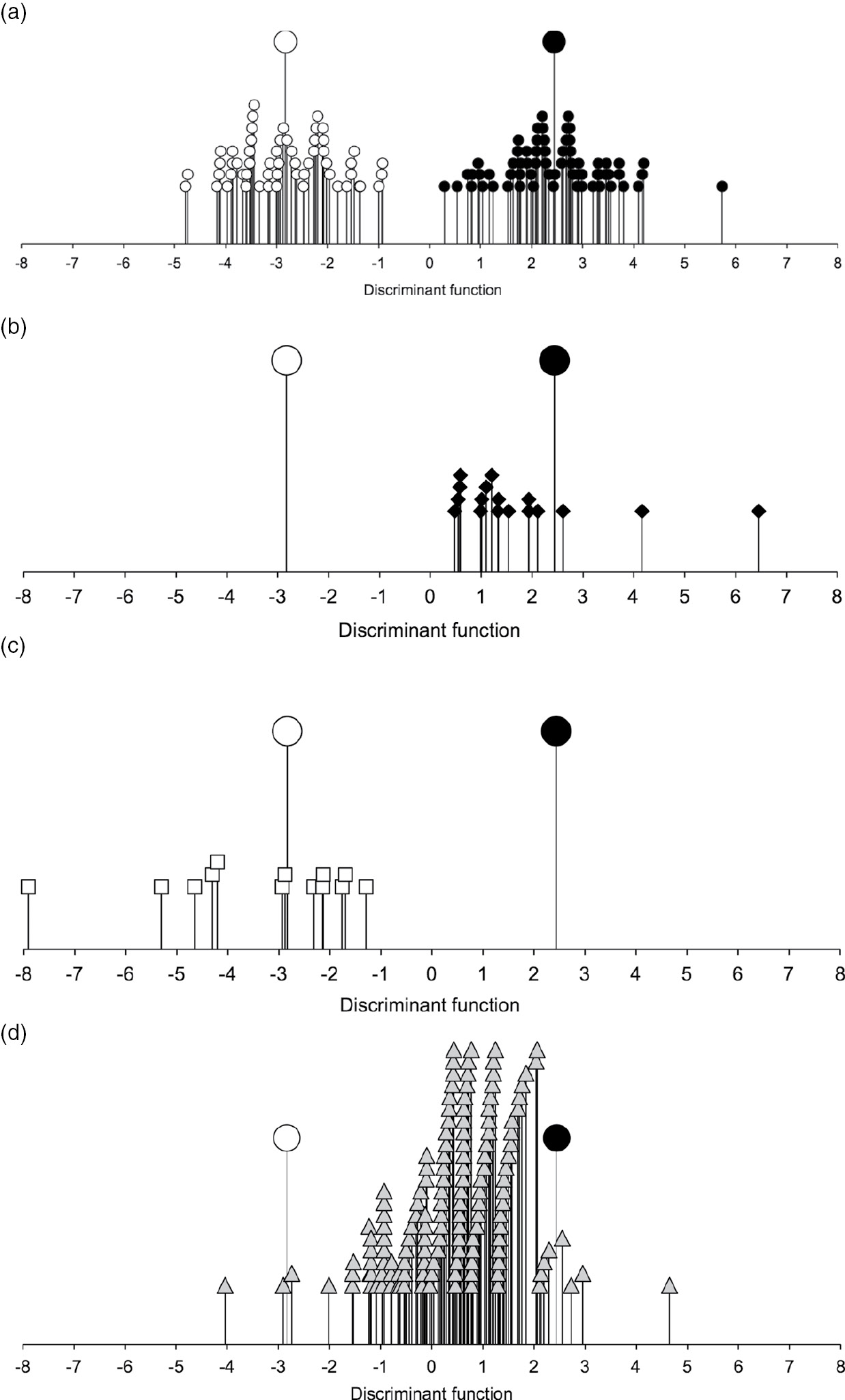
Figure 7.4 The relationship of a. Haute Provence fields (open circles, n = 56) and Asturias fields (filled circles, n = 65), b. Sighisoara fields (filled diamonds, n = 17), c. Kastamonu fields (open squares, n = 13) and d. archaeobotanical samples from Neolithic Central Europe (grey triangles, n = 141) to the discriminant function extracted to distinguish the Haute Provence and Asturias groups on the basis of semi-quantitative (presence/absence) weed functional attribute scores. Larger symbols indicate centroids for Haute Provence and Asturias.
Though the palaeoeconomists despaired of the possibility that manuring and crop rotation could ever be reconstructed archaeologically (in the absence of documentary evidence), stable carbon and nitrogen isotope analysis of crop remains has begun to open up that opportunity (see also Chapter 3). In C3 plants like wheat, barley and pulses, it has been shown that stable carbon isotope ratios (δ13C values) in plant tissues variously reflect stomatal conductance, which determines the degree of discrimination against the heavier stable isotope, 13C (Farquhar et al. Reference Farquhar, Ehleringer and Hubick1989). How open or closed the stomata are, in turn, is affected in arid regions by water availability and in more humid zones, where water is not limiting, especially by canopy, salinity and other effects (Farquhar et al. Reference Farquhar, Ehleringer and Hubick1989). Stable nitrogen isotope ratios (δ15N values), by contrast, reflect the nitrogen composition of soil, which in arable conditions is determined above all by the addition of organic matter, that is, manuring/middening (Bogaard et al. Reference Bogaard, Heaton, Poulton and Merbach2007; Fraser et al. Reference Fraser, Bogaard, Heaton, Charles, Jones and Christensen2011; Peukert et al. Reference Peukert, Bol, Roberts, Macleod, Murray, Dixon and Brazier2012). While factors such as shade and topography are clearly more likely to affect LBK crop stable carbon isotope variation than water management, the possibility of manuring can be assessed by measuring stable nitrogen isotope values in grain, and comparing them with present-day manuring effects plus local environmental baselines for unmanured vegetation derived from stable nitrogen isotope measurements of associated herbivore bone collagen, ideally from wild herbivores least affected by any anthropogenic enrichment (Styring et al. Reference Styring, Ater, Hmimsa, Fraser, Miller and Neef2016a; Nitsch et al. Reference Nitsch, Andreou, Creuzieux, Gardeisen, Halstead and Isaakidou2017). The plausibility of crop rotation or intercropping – that is, growing of multiple crop species under similar field conditions, and hence potentially in rotation or as a mixed crop – can be assessed by comparing their stable carbon and nitrogen isotope ratios, with the proviso that there are physiological offsets between some crops (i.e. wheat and barley) in their stable carbon isotope ratios when grown under the same conditions (e.g. Wallace et al. Reference Wallace, Jones, Charles, Fraser, Halstead, Heaton and Bogaard2013).
Like the weed ecological approach, interpretation of crop stable isotope values as evidence of growing conditions and land management in archaeology has depended on present-day observations of cause and effect; agronomic effects on stable carbon and nitrogen isotope ratios are most easily discerned in experimental settings, but ‘real world’ variation in traditional farming systems, on differing soils and in contrasting climatic zones, is equally crucial as background knowledge for interpreting archaeological values. Reliable interpretation of these values has also depended on laboratory work to establish the effects of charring on grain composition and stable isotope ratios (Styring et al. Reference Styring, Manning, Fraser, Wallace, Jones and Charles2013; Fraser et al. Reference Fraser, Bogaard, Charles, Styring, Wallace, Jones and Ditchfield2013a; Nitsch et al. Reference Nitsch, Charles and Bogaard2015), the effects of pre-treatment prior to stable isotope measurement for removing contamination (Vaiglova et al. Reference Vaiglova, Snoeck, Nitsch, Bogaard and Lee-Thorp2014) and possible diagenetic effects during burial (Styring et al. Reference Styring, Manning, Fraser, Wallace, Jones and Charles2013). Finally, integration with faunal isotope measurements is important for assessing unmanured baselines (Styring et al. Reference Styring, Ater, Hmimsa, Fraser, Miller and Neef2016a; Nitsch et al. Reference Nitsch, Andreou, Creuzieux, Gardeisen, Halstead and Isaakidou2017), while the combination of complementary weed ecological and crop isotope approaches to a given assemblage offers the robusticity of two independent methods subject to different sources of error and ambiguity (Bogaard Reference Bogaard, Halstead, Fowler, Harding and Hofmann2015; Bogaard et al. Reference Bogaard, Hodgson, Nitsch, Jones, Styring and Diffey2016, Reference Bogaard, Ater, Hodgson, Stépanoff and Vigne2018).
For the LBK, stable isotope analysis of crop remains has so far been limited to two assemblages – Vaihingen an der Enz and Viesenhäuser Hof/Stuttgart-Mühlhausen, both in south-west Germany (Fraser et al. Reference Fraser, Bogaard, Schäfer, Arbogast and Heaton2013b; Styring et al. Reference Styring, Rösch, Stephan, Stika, Fischer, Sillmann and Bogaard2017b) – but with relevant implications for the plausibility of manuring and crop rotation. At both sites, cereal δ15N values are elevated well above those of herbivore forage, inferred from bone collagen, and especially above those of wild herbivores at Vaihingen (a single, similar wild herbivore bone collagen sample was analysed from Viesenhäuser Hof) (Fig. 7.5). This observation is consistent with manuring. Very few pulse samples have been analysed from either site, but the values available are also consistent with manuring effects. Moreover, the elevation of domestic herbivore δ15N values above those of wild herbivores at Vaihingen is consistent with some foddering on (manured) crop material; palaeodietary modelling suggests that domestic herbivores at both Vaihingen and Viesenhäuser Hof could have consumed cereal chaff (including stubble in harvested fields) as part of their diets (Styring et al. Reference Styring, Rösch, Stephan, Stika, Fischer, Sillmann and Bogaard2017b: Appendix S.7).
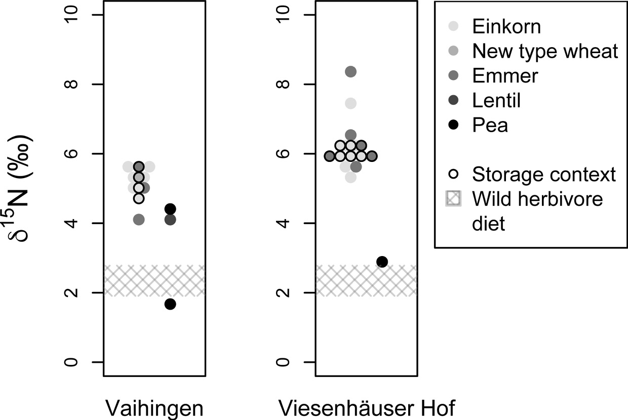
Figure 7.5 The δ15N values of bulk cereal grain and pulse seed samples from LBK Vaihingen and Viesenhäuser Hof, Baden-Württemberg (after Styring et al. Reference Styring, Rösch, Stephan, Stika, Fischer, Sillmann and Bogaard2017b: Fig. 3). Higher δ15N values indicate higher inputs of organic matter/manure and the grey cross-hatched zone shows the possible δ15N values of unmanaged vegetation, estimated from wild herbivore bone collagen δ15N values. Sample data points outlined in black are from high-density ‘storage’ deposits.
The plausibility of cereal–pulse rotation or intercropping is more difficult to assess, since few pulse samples have been analysed isotopically, and most derive from different archaeological contexts/deposits to the cereals. In any case, the beneficial effect of pulse cultivation on soil nitrogen content depends on the extent to which pulse plant matter is worked into the soil. The plausibility of rotation or inter-cropping amongst the glume wheats, einkorn, emmer (and ‘new type’), however, can be assessed, since multi-species, high-density grain deposits, apparently representing dumps of associated charred storage material, were analysed from both sites. While rotation/intercropping of cereals does not have the same implications as cereal–pulse rotation for maintaining soil fertility, it is relevant to consider whether one cereal was preferentially manured over another, as in the late Neolithic of the lakeshore dwellings in the Alpine foreland (see below). The similarity in isotopic compositions within storage deposits at LBK Vaihingen and Viesenhäuser Hof (Fig. 7.5) suggests that emmer and einkorn (and ‘new type’ glume wheat at Vaihingen) were grown under the same conditions, quite possibly in a mixed/maslin crop given their stratigraphic association (Fraser et al. Reference Fraser, Bogaard, Schäfer, Arbogast and Heaton2013b; Styring et al. Reference Styring, Rösch, Stephan, Stika, Fischer, Sillmann and Bogaard2017b). Whether or not the glume wheats were actually grown together as a mixed crop, the fact that they were apparently grown under similar conditions suggests that LBK farmers here maintained an arable niche that was remarkably consistent, and that did not necessitate separate treatment of relatively more/less demanding crops, as emerges in the later Neolithic of the Alpine foreland (see below). It is plausible that the particularly favourable environments targeted by LBK farmers made this strategy feasible.
Turning to the pastoral side of farming practice, there have been several key developments since the early 1980s. First, as already noted, recovery of many more faunal assemblages from LBK sites confirms the dominance of cattle, but also chronologically and regionally distinctive levels of pigs and small ruminants, and of hunting. Second, ancient DNA studies indicate that early Neolithic cattle and pig were of western Asiatic origin (Bollongino et al. Reference Bollongino, Edwards, Alt, Burger and Bradley2006, Reference Bollongino, Elsner, Vigne and Burger2008; Edwards et al. Reference Edwards, Bollongino, Scheu, Chamberlain, Tresset and Vigne2007). The genetic traces of the intrusive pigs were overwritten by the later Neolithic through interbreeding with European wild boar (Larson et al. Reference Larson, Albarella, Dobney, Rowley-Conwy, Schibler and Tresset2007; Ottoni et al. 2012; Larson and Burger Reference Larson and Burger2013; Larson and Fuller Reference Larson and Fuller2014). This scenario is highly plausible: it has been shown ethnographically that keeping wild and domestic pigs separate is very difficult (Halstead and Isaakidou Reference Halstead, Isaakidou and Albarella2011). Neolithic domestic cattle appear to have been kept separate from local wild populations based on mtDNA (Edwards et al. Reference Edwards, Bollongino, Scheu, Chamberlain, Tresset and Vigne2007; Bollongino et al. Reference Bollongino, Elsner, Vigne and Burger2008), though whole-genome data may reveal a more complex picture (cf. Orlando et al. Reference Orlando2015; Parks et al. Reference Park, Magee, McGettigan, Teasdale, Edwards and Lohan2015). The slow pace of domestic–wild pig introgression, the apparent genetic isolation of domestic cattle and the metric distinctiveness of wild and domestic populations suggest that LBK herding was generally small-scale and intensive (Benecke Reference Benecke1994a: 48–55).
Third, recovery of larger faunal assemblages has enabled the characterization of animal consumption and husbandry in greater detail. In particular, mortality profiles of cattle point to the likelihood of multi-purpose husbandry, featuring the maintenance of older animals for possible use of milk as well as meat (Gillis et al. Reference Gillis, Kovačiková, Bréhard, Guthmann, Vostrovská and Nohálová2017; Bogaard et al. Reference Bogaard, Arbogast, Ebersbach, Fraser, Knipper and Krahn2017a). Such multi-purpose husbandry – rather than specialized intensive dairying – plausibly forms the context of milk lipid residues detected on ceramic sieves on LBK sites in the Kujavia region of Poland (Salque et al. Reference Salque, Bogucki, Pyzel, Sobkowiak-Tabaka, Grygiel, Szmyt and Evershed2013). Non-dairy animal fat residues, as well as plant-derived lipids, were recently detected on ceramics from LBK Bylany in the Czech Republic, suggesting that milk processing was rare or absent (Matlova et al. Reference Matlova, Roffet-Salque, Pavlu, Kyselka, Sedlarova, Filip and Evershed2017).
Decorated figurines of cattle (Fig. 7.6) show that they had symbolic significance over and above their economic roles (e.g. Bogaard Reference Bogaard2011: Fig. 1.15). The remarkable metric consistency of cattle across many sites (Bogaard et al. Reference Bogaard, Arbogast, Ebersbach, Fraser, Knipper and Krahn2017a) confirms the likelihood of systematic exchanges and periodic merging of herds, not least to maintain viability (cf. Halstead Reference Halstead1992; Ebersbach Reference Ebersbach2002). Observations of traction-related pathology are rare (Döhle Reference Döhle1997), while meat-oriented culling patterns and depositional practices at some sites attest to large-scale consumption/feasting (e.g. Gillis et al. Reference Gillis, Kovačiková, Bréhard, Guthmann, Vostrovská and Nohálová2017). The scale of LBK herding probably remained small (Knipper Reference Knipper2011: 275; Bogaard et al. Reference Bogaard, Arbogast, Ebersbach, Fraser, Knipper and Krahn2017a; cf. Schibler Reference Schibler, Arbogast, Jeunesse and Schibler2001).
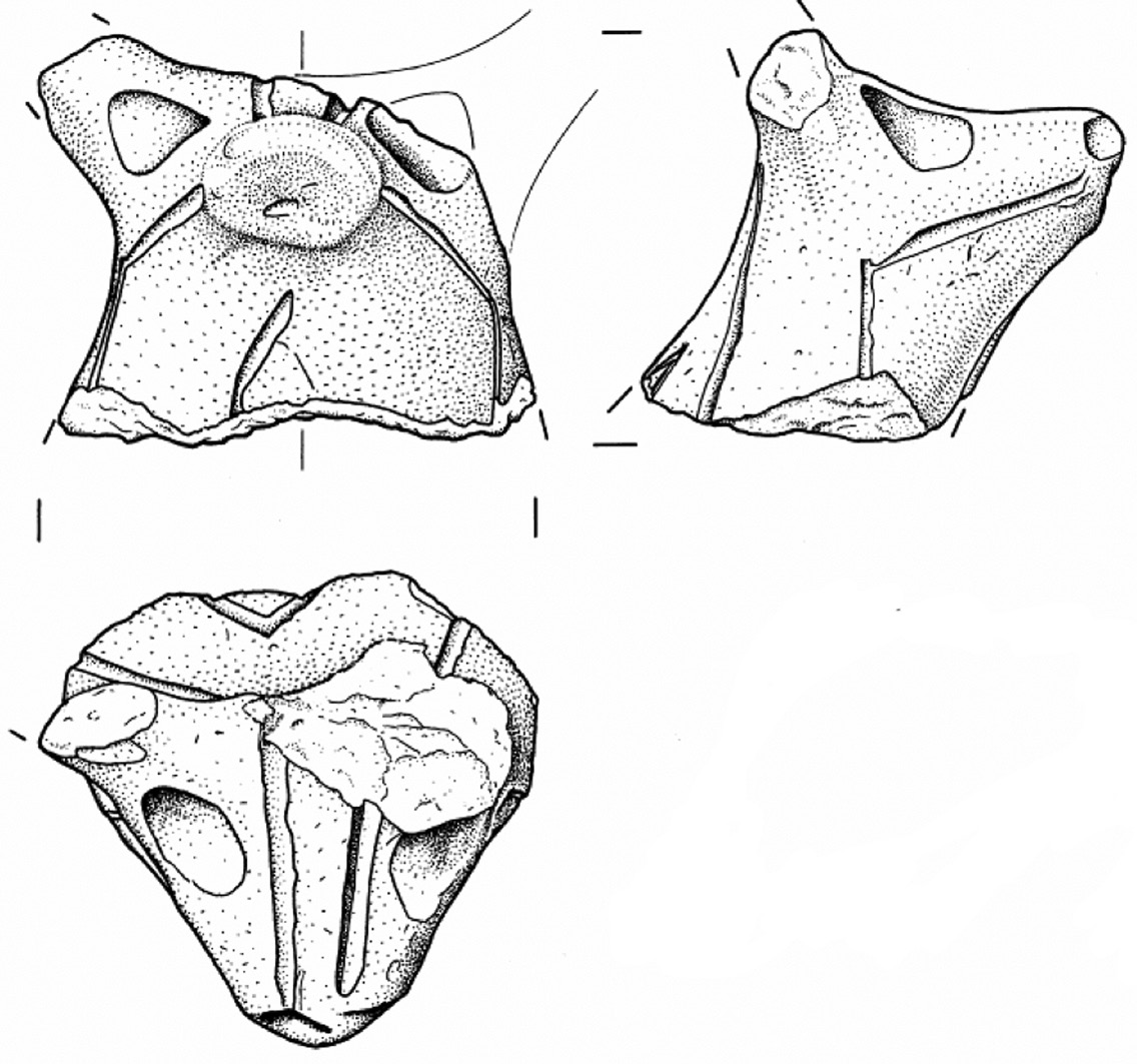
Figure 7.6 Head of a clay bull figurine decorated with incised lines from LBK Vaihingen an der Enz (height 5.7 cm, Inv Nr. 4643).
Fourth, analysis of stable (O, C, N) and radiogenic (Sr) isotopes in faunal remains has begun to refine understanding of livestock feeding ecologies and management strategies. Knipper’s strontium and oxygen isotope study of LBK cattle teeth in south-west Germany, featuring sequential sampling of tooth enamel to investigate individual life histories, provides a particularly clear example of how isotopic data can be used to test land-use inferences based on territorial analysis/SCA (Knipper Reference Knipper2011). In the case of Vaihingen, with its large and well preserved faunal assemblage, comparison of potential foraging zones in 2- and 5-km radii of the settlement with actual foraging behaviour as evidenced in the Sr isotope ratios of tooth enamel showed that feeding on loess and shelly limestone of local river valleys was over-represented relative to their availability in the landscape (Knipper Reference Knipper2011: Figs. 9.45–9.46; see also Bogaard et al. Reference Bogaard, Arbogast, Ebersbach, Fraser, Knipper and Krahn2017a: Fig. 24) (Fig. 7.7). Feeding on geology consistent with upland grazing was under-represented (Fig. 7.7). The implication is that LBK herders targeted the rolling loess landscape surrounding the settlement, nearby streams and the Enz river valley for herding that was likely to have been restricted in scale and integrated with arable activity (Knipper Reference Knipper2011: 278). A smaller set of cattle teeth from Hilzingen suggests targeting of river valleys for grazing (Knipper Reference Knipper2011: Fig. 9.61), further confirming the inference by Jarman et al. (Reference Jarman, Bailey and Jarman1982: 194–8) that valley bottoms were important sources of productive grazing for LBK herders.
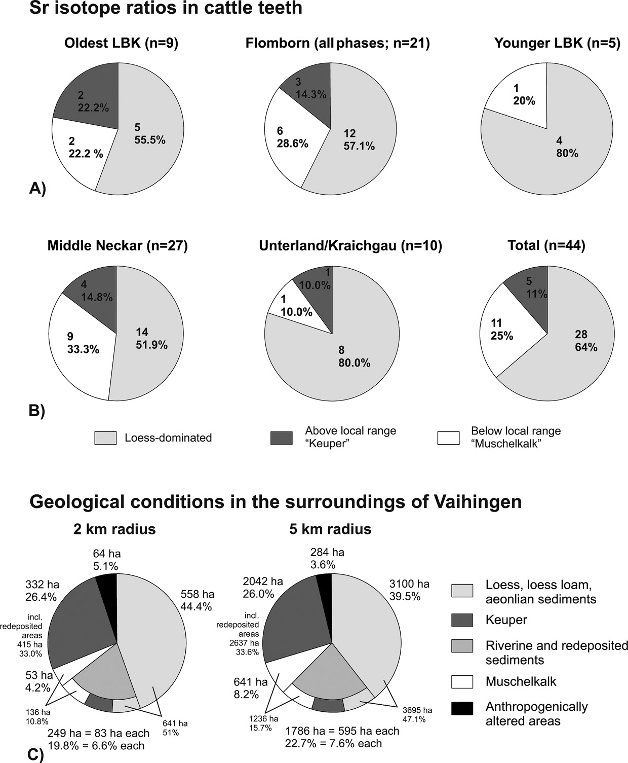
Figure 7.7 Distribution of Sr isotope ratios in cattle teeth at LBK Vaihingen by a. LBK subperiod and b. regional ceramic tradition, in comparison with c. proportional areas of dominant geological substrates: loess, shelly limestone (Muschelkalk) and Keuper sandstone.
A final aspect of LBK economy with direct bearing on the palaeoeconomists’ discussion is the way in which integrated stable carbon and nitrogen isotope analysis of human, faunal and plant remains opens up more explicit testing of dietary scenarios. Though only two assemblages – Vaihingen and Viesenhäuser Hof/Stuttgart-Mühlhausen – have as yet been analysed in this way, the results of both investigations suggest that crops (e.g. an even mix of cereals and pulses) were if anything more important staple foods than livestock meat/milk (Fraser et al. Reference Fraser, Bogaard, Schäfer, Arbogast and Heaton2013b; Nitsch et al. Reference Nitsch, Charles and Bogaard2015; Bogaard and Styring Reference Bogaard, Styring, Lee-Thorp and Katzenberg2017) (Fig. 7.8). While lipid analysis results indicate that milking was practised in the LBK at some sites and not others (Salque et al. Reference Salque, Bogucki, Pyzel, Sobkowiak-Tabaka, Grygiel, Szmyt and Evershed2013; Matlova et al. Reference Matlova, Roffet-Salque, Pavlu, Kyselka, Sedlarova, Filip and Evershed2017), mortality data show that milking could not have been intensive (Gillis et al. Reference Gillis, Kovačiková, Bréhard, Guthmann, Vostrovská and Nohálová2017). Low to moderate levels of milk consumption can inform understanding of selection pressure for lactase persistence in Central Europe (e.g. Itan et al. Reference Itan, Powell, Beaumont, Burger and Thomas2009; Gerbault et al. Reference Gerbault, Liebert, Itan, Powell, Currat and Burger2011). The (as yet) limited number of humans sampled from Neolithic Central Europe has not yielded early examples of lactase persistence, though the relationship with milk consumption is not straightforward (Burger et al. Reference Burger, Kirchner, Bramanti, Haak and Thomas2007; Liebert et al. Reference Liebert, Lopez, Jones, Montalva, Gerbault and Lau2017). Overall, emerging isotope-based and palaeodietary reconstructions of the LBK appear to confirm the palaeoeconomic hypothesis based on site catchment analysis that the location of sites in zones of high arable potential, combined with productive grazing in adjacent valley bottoms, was central to subsistence.
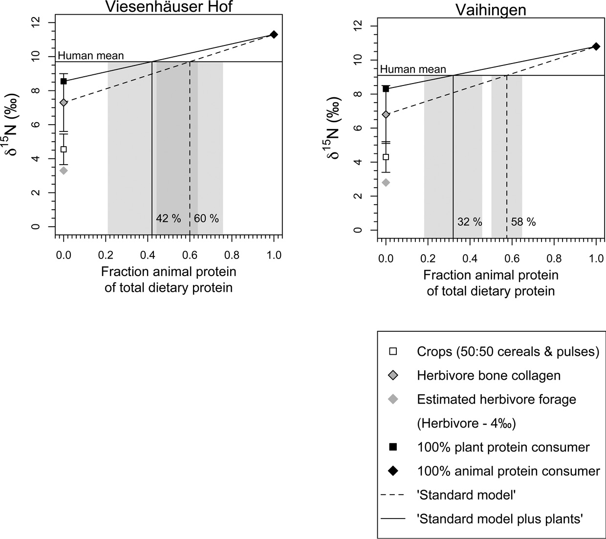
Figure 7.8 Palaeodietary models estimating the proportion of animal protein in the diets of Neolithic humans buried at LBK Vaihingen and Viesenhäuser Hof (after Bogaard and Styring Reference Bogaard, Styring, Lee-Thorp and Katzenberg2017: Fig. 14.3). The ‘standard model’ is based on the assumption that humans eating only plant protein would have the same bone collagen δ15N value as herbivores from the site and therefore the plants they were eating had the same δ15N value as herbivore forage (i.e. grasses, leaves and twigs). The ‘standard model plus plants’ uses the measured δ15N values of cereal grains and pulses to estimate the δ15N value of humans eating cereals. Models incorporate data from Fraser et al. (Reference Fraser, Bogaard, Charles, Styring, Wallace, Jones and Ditchfield2013), Styring et al. (Reference Styring, Fraser, Arbogast, Halstead, Isaakidou and Pearson2015) and Styring et al. (Reference Styring, Rösch, Stephan, Stika, Fischer, Sillmann and Bogaard2017b). The grey shading represents the 95% confidence interval for animal protein consumption calculated using IsoError (www.epa.gov/wed/pages/models.htm; accessed 1 July 2016).
Neolithic Economy in the Alpine Foreland, with Particular Reference to Lake Constance
In the Alpine foreland (Jarman et al. Reference Jarman, Bailey and Jarman1982: 120–9), where the late Neolithic sequence dates are c. 4300–2400 bc, Lake Constance (Bodensee) was the focus of the palaeoeconomists’ analysis. They noted that Neolithic lakeshore settlements here were conspicuously clustered in a narrow zone of relatively mild climate and low rainfall, especially around the western end of the lake, and that the lighter morainic soils would not be very different in fertility and tractability from the loess. The key limitations were instead imposed by climate and topography away from the lakeshore (Jarman et al. Reference Jarman, Bailey and Jarman1982: 122). They inferred that the lakeshore location enabled communities to grow crops and overwinter livestock in a relatively favourable zone, while making use of lacustrine and terrestrial resources. Amongst the individual site territories analysed was that of Sipplingen-Osthafen, on the north-western shore (Jarman et al. Reference Jarman, Bailey and Jarman1982: Fig. 42). This site’s setting immediately poses the question of where the arable land was located: slopes rise steeply to a plateau a few hundred metres from the shore, creating a narrow strip of c. 2 km2 behind the lake-edge settlement. Though agricultural activity is today concentrated on the elevated plateau, Jarman et al. (Reference Jarman, Bailey and Jarman1982: 123–5) reasoned that the lakeside strip had the advantages of immediate access and favourable microclimate. We will consider the particular case of Sipplingen later in this chapter.
Since the 1980s there has been an explosion of bioarchaeological research on the lakeshore sites of the Alpine foreland, now listed as a UNESCO World Heritage site (Hafner Reference Hafner and Roio2013). Lake Zurich, Lake Constance and the Federsee have been particular focal points, and a nuanced picture of settlement and land-use has emerged, especially from the interdisciplinary work of the Institut für Prähistorische und Naturwissenschaftliche Archäologie in Basel, Switzerland, and the Landesdenkmalamt Baden-Württemberg, Germany. These research groups have handled sampling and primary analysis of bioarchaeological remains from the complex stratigraphic sequences of lakeshore sites, integrated these findings with those of dendrochronological, material culture and palaeoecological studies (e.g. Maier and Vogt Reference Maier and Vogt2001; Jacomet et al. Reference Hosch, Jacomet, Jacomet, Leuzinger and Schibler2004) and conducted pioneering applications of many recent analytical techniques, including lipid residue, multi-isotope and aDNA analysis (Larson et al. Reference Larson, Albarella, Dobney, Rowley-Conwy, Schibler and Tresset2007; Spangenberg et al. Reference Spangenberg, Matuschik, Jacomet and Schibler2008; Styring et al. Reference Styring, Maier, Stephan, Schlichtherle and Bogaard2016; Gerling et al. Reference Gerling, Doppler, Heyd, Knipper, Kuhn and Lehmann2017). Understanding of daily life and social change in the Alpine foreland is therefore generally more detailed and multi-stranded than anywhere else in Europe. This high-resolution picture is difficult in some ways to compare directly with that reconstructed for dryland settings, including the LBK and subsequent Neolithic of the loess belt. Nevertheless, key inferences on the nature of crop and animal husbandry and its development over time suggest that convergent agropastoral practices developed in both zones of Central Europe (Bogaard et al. Reference Bogaard, Jacomet, Schibler, Bickle, Cummings, Hofmann and Pollard2017b).
A fundamental inference that unites the dryland Neolithic of the loess belt and wetland Neolithic of the Alpine foreland is the rejection of the shifting cultivation model, based on direct evidence of crop-growing conditions (Jacomet and Brombacher Reference Brombacher1997; Bogaard Reference Bogaard2002, Reference Bogaard2004; Hosch and Jacomet Reference Hosch, Jacomet, Jacomet, Leuzinger and Schibler2004). Nevertheless, there has been a revival of the slash-and-burn hypothesis for the Alpine foreland Neolithic based on off-site pollen and microcharcoal data (e.g. Schier Reference Schier2009; Rösch et al. Reference Rösch, Kleinmann, Lechterbeck and Wick2014). Critical reappraisal of on- and off-site data in the Alpine foreland resolves this contradiction: while on-site archaeobotanical data attest to intensively maintained arable conditions (e.g. weeding, likely manuring), the off-site pollen and microcharcoal data plausibly reflect larger scale patterns of land use for livestock grazing, hunting and foraging that included burning parts of the landscape (Jacomet et al. Reference Jacomet, Ebersbach, Akeret, Antolín, Baum and Bogaard2016). This integrated understanding of land use, in turn, sheds light on Neolithic lakeshore settlement dynamics. Dendrochronological dating of lakeshore houses and settlements attests to short use-lives and high ‘mobility’ of settlement, but within long established zones of settlement and land use. An example of this phenomenon on the western shore of Lake Constance is Hornstaad-Hörnle I and its replacement by Hornstaad-Hörnle 3: the earlier settlement was established in 3917 bc, burned down in 3910 and was replaced in 3909 by the later settlement a few hundred metres away (Billamboz Reference Billamboz, Dieckmann, Harwath, Hoffstadt and Billamboz2006). A ‘tethering’ of shifting settlements to established managed landscapes is also suggested by analysis of the long-term Neolithic sequence at the northern end of Lake Zurich (Ebersbach et al. Reference Ebersbach, Ruckstuhl and Bleicher2015).
The 1,200-year (4000–2800 bc) multi-settlement sequence at Sipplingen-Osthafen offers a clear example of how archaeological economic reconstruction continues to resonate with site catchment potentials highlighted by Jarman et al. (Reference Jarman, Bailey and Jarman1982: 123–5), but aims to test these hypotheses using relevant evidence. Baum et al. (Reference Baum, Nendel, Jacomet, Colobran and Ebersbach2016) have combined agent-based and process-based biophysical modelling to the Sipplingen case, demonstrating how differently a shifting/slash-and-burn versus intensive ‘garden’ model of cultivation would be accommodated in the surrounding landscape. Their quantification of shifting and intensive/permanent arable requirements when settlement reached a maximum (100 households) indicates that permanent cultivation could be accommodated within the climatically favoured ‘strip’ of light soils immediately behind the settlement, whereas shifting cultivation would extend onto the steeply rising plateau beyond (Baum et al. Reference Baum, Nendel, Jacomet, Colobran and Ebersbach2016: Fig. 9) (Fig. 7.9). Baum et al. (Reference Baum, Nendel, Jacomet, Colobran and Ebersbach2016) also suggest, using biophysical modelling, that manuring was needed to maintain local fertility and yields. A separate study by Styring et al. (Reference Styring, Maier, Stephan, Schlichtherle and Bogaard2016) used stable nitrogen isotope analysis of charred cereal grains from the various phases at Sipplingen to assess the likelihood of manuring and continuity versus change over the long-term. This study revealed that wheat (initially free-threshing wheat, later emmer) was grown under more intensively manured conditions than naked barley, and this pattern persisted over more than a millennium, including a hiatus in settlement – 3600–3300 bc – (Fig. 7.10). This behaviour makes sense, given that modest stocking levels would limit manure availability, encouraging strategic use of manure on the more demanding/responsive crop.
Figure 7.9 Simulations of the spatial extents of two different arable land-use models at Sipplingen, Lake Constance: a. intensive garden cultivation, b. shifting cultivation with long fallow.
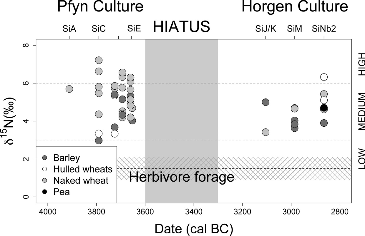
Figure 7.10 The δ15N values of bulk cereal grain and pulse seed samples through the occupation of Sipplingen, Lake Constance, c. 4000–2800 bc; the dotted black line is the mean estimated herbivore plant diet; the grey cross-hatching is 1 standard deviation; low, medium and high manuring levels are defined from modern, long-term experimental farming plots.
The strategic approach to differentially manured cereal crops at late Neolithic Sipplingen contrasts with LBK farming practice at Vaihingen and Viesenhäuser Hof/Stuttgart-Mühlhausen (Fraser et al. Reference Fraser, Bogaard, Schäfer, Arbogast and Heaton2013b; Styring et al. Reference Styring, Rösch, Stephan, Stika, Fischer, Sillmann and Bogaard2017b), where multiple glume wheat taxa were grown under similar conditions, possibly as a mixed/maslin crop. Different explanations of this contrast in approach to cereals are possible, and not mutually exclusive. First, LBK farmers may not have regarded the glume wheats as differentially responsive to fertility, and/or the pronounced dominance of one glume wheat taxon (often einkorn) may have encouraged undifferentiated management. Second, the spread of farming towards the Alpine foreland – associated with a trend towards higher hunting levels within the LBK (Schibler Reference Schibler, Arbogast, Jeunesse and Schibler2001) – possibly entailed adjustments, since farming outcomes were increasingly affected by climatic oscillations (Bogaard et al. Reference Bogaard, Jacomet, Schibler, Bickle, Cummings, Hofmann and Pollard2017b), encouraging a more strategic approach to cereals. Wheat and barley also had distinct culinary uses in the late Neolithic Alpine foreland (Styring et al. Reference Styring, Maier, Stephan, Schlichtherle and Bogaard2016). Third, the mechanism(s) and forms of manuring/middening may have differed (Bogaard et al. Reference Bogaard, Arbogast, Ebersbach, Fraser, Knipper and Krahn2017a).
Finally, turning to the herding aspect of the economy, recent analysis of a lakeshore site on the southern shore of Lake Constance, Arbon Bleiche 3, has shed new light on animal herding and consumption over this settlement’s fifteen-year span (Gerling et al. Reference Gerling, Doppler, Heyd, Knipper, Kuhn and Lehmann2017). Arbon Bleiche 3 has been subject to remarkably detailed excavation and sampling, which inter alia reveals social geographical patterning across the settlement (Jacomet et al. Reference Hosch, Jacomet, Jacomet, Leuzinger and Schibler2004). In terms of animal consumption, detection of ruminant milk lipids on ceramics (Spangenberg et al. Reference Spangenberg, Matuschik, Jacomet and Schibler2008), cattle pathologies suggestive of traction (a wooden yoke was also found) (Leuzinger Reference Leuzinger, de Capitani, Deschler-Erb, Leuzinger, Marti-Grädel and Schibler2002; Deschler-Erb and Marti-Grädel Reference Deschler-Erb, Marti-Grädel, Jacomet, Leuzinger and Schibler2004) and finds of bucrania hung on the outside walls of houses (Deschler-Erb et al. Reference Deschler-Erb, Marti-Grädel and Schibler2002; Deschler-Erb and Marti-Grädel Reference Deschler-Erb, Marti-Grädel, Jacomet, Leuzinger and Schibler2004) combine to suggest that livestock, especially cattle, were valued for multiple uses. Gerling et al. (Reference Gerling, Doppler, Heyd, Knipper, Kuhn and Lehmann2017) recently investigated cattle-herding strategies in detail using high-resolution sequential cattle tooth enamel measurements of strontium isotope ratios in twenty-five individuals, combined with baseline mapping of Sr variability in the wider landscape. The authors discern three kinds of mobility and herding practice: cattle-keeping immediately around the settlement (cf. overwintering in climatically favourable lakeshore zones, Jarman et al. Reference Jarman, Bailey and Jarman1982: 122), seasonal movement beyond the settlement area and non-local herding year-round (Gerling et al. Reference Gerling, Doppler, Heyd, Knipper, Kuhn and Lehmann2017). They exclude large-scale Alpine cattle migration. While some of this patterning may reflect movement of cattle brought in by the settlement’s founders, and/or acquisition of animals from other communities, clustering of cattle remains with distinctive herding strategies in the settlement suggests that multiple neighbouring households were engaged in similar practices. This social geographical side of economic practice informs the question of identity construction in Neolithic communities, to which we turn in the final section of this chapter.
Integrated Perspectives on Identity and Inheritance in Neolithic Central Europe
Human aDNA studies, beginning with mitochondrial aDNA and now incorporating genome-wide data, have begun to provide a direct answer to long-standing questions regarding ‘colonization versus acculturation’ as demographic processes underlying the spread of farming in Europe (see also Chapter 5; Haak et al. Reference Haak, Forster, Bramanti, Matsumura, Brandt and Tänzer2005, Reference Haak, Lazaridis, Patterson, Rohland, Mallick and Llamas2015; Bramanti et al. Reference Bramanti, Thomas, Haak, Unterländer, Jores and Tambets2009; Lipson et al. Reference Lipson2017). The emerging picture is that in certain regions, including Central Europe, early farmers were descended from ‘Anatolians’, and hence that the spread of farming involved considerable population movement (Bramanti et al. Reference Bramanti, Thomas, Haak, Unterländer, Jores and Tambets2009; Haak et al. Reference Haak, Lazaridis, Patterson, Rohland, Mallick and Llamas2015). Neolithic populations in different regions reflect varying levels of ‘admixture’ with local hunter-gatherer populations, and later demographic input from the East European steppe (Haak et al. Reference Haak, Forster, Bramanti, Matsumura, Brandt and Tänzer2005, Reference Haak, Lazaridis, Patterson, Rohland, Mallick and Llamas2015; Bramanti et al. Reference Bramanti, Thomas, Haak, Unterländer, Jores and Tambets2009; Allentoft et al. Reference Allentoft, Sikora, Sjögren, Rasmussen, Rasmussen and Stenderup2015; Haak et al. Reference Haak, Lazaridis, Patterson, Rohland, Mallick and Llamas2015; Lipson et al. Reference Lipson2017). Though the numbers of samples on which these new reconstructions are based are in the hundreds, there is still need for caution in extrapolating from these results, and in interpreting them. It is clear that aDNA studies will increasingly provide direct evidence for human genetic heritage. Equally, Haak et al. (Reference Haak, Lazaridis, Patterson, Rohland, Mallick and Llamas2015) cannot resist interpreting their genetic data also in terms of debate over Indo-European origins, though the specific data they consider do not directly address this debate.
An important consequence of the aDNA breakthrough for palaeoeconomic enquiry is that archaeologists are now increasingly ‘free’ to interpret bone and seed evidence for land use and food-related practice as precisely that, and not to stretch ‘economic’ arguments to address questions surrounding the genetic origins of the early farmers (cf. Bogaard and Halstead Reference Bogaard, Halstead, Fowler, Harding and Hofmann2015). As the palaeoeconomists had observed, shifting cultivation as a (problematic) model for the LBK was attractive to Childe (Reference Childe1929, Reference Childe1957) and Clark (Reference Clark1952) because it helped to explain the (presumed) demographic spread (Jarman et al. Reference Jarman, Bailey and Jarman1982: 134). Given the emerging aDNA and agroecological reconstruction for the LBK, it is now apparent both that significant demographic spread was likely involved, and that people were managing long-established plots with considerable (though variable) labour intensity. Clearly, the LBK farming regime did not directly entail demographic spread in the way it might be argued to do for residentially mobile shifting cultivators (cf. Bogaard Reference Bogaard2004: 155). But the detailed history of individual settlements and the way in which households and groups arrived and departed provide important clues to why the LBK spread in the way that it did (Bogaard et al. Reference Bogaard, Krause and Strien2011, Reference Bogaard, Arbogast, Ebersbach, Fraser, Knipper and Krahn2017a). Explaining this argument requires some additional background on regional and local LBK social geographies.
Detailed study of material culture across LBK settlements has revealed that individual communities could be composed of households/groups with contrasting material culture and different affiliations to regional complexes (e.g. Fridrich Reference Fridrich, Lüning and Stehli1994; Lüning Reference Lüning2006; Claßen Reference Claβen2011). Intra-site variation in economic practices, such as hunting levels, has also been noted (Hachem Reference Hachem, Breamer, Cleuziou and Coudart1999, Reference Hachem2000). Integrated bioarchaeological and material culture study at Vaihingen an der Enz, Baden-Württemberg shows that differences in material culture and economic practice coincide to an extent (Bogaard et al. Reference Bogaard, Krause and Strien2011, Reference Bogaard, Arbogast, Ebersbach, Fraser, Knipper and Krahn2017a). It therefore appears plausible that food-related practice contributed to the construction of social identities and differences within communities (cf. Robb and Miracle Reference Robb, Miracle, Whittle and Cummings2007). In the earlier part of the sequence, households at Vaihingen belonged to one of two regional material culture traditions, identified on the basis of specific features including stone axe/adze forms: the local Middle Neckar group and the northerly Unterland-Kraichgau group (Strien Reference Strien, Lüning, Fridrich and Zimmerman2005, Reference Strien and Bogaard2011, Reference Strien, Beier, Einicke and Biermann2014). It appears likely that one particular Middle Neckar lineage founded the settlement. Weed ecological analysis shows that households belonging to the local Middle Neckar group were associated with the most intensively managed plots – probably those located immediately around the settlement (Bogaard Reference Bogaard2011; Bogaard et al. Reference Bogaard, Krause and Strien2011, Reference Bogaard, Arbogast, Ebersbach, Fraser, Knipper and Krahn2017a). Households belonging to the Unterland-Kraichgau tradition, by contrast, were associated with less disturbed conditions, probably reflecting plots that were further away from the settlement. These differences persisted over phases and generations spanning around two centuries, suggesting that they reflect differences in land holdings, and a practice of land inheritance within these groups. When the Unterland-Kraichgau-affiliated households left midway through the occupation sequence, leaving only Middle Neckar households, the persisting arable conditions were exclusively of the intensively managed type. By this time, an oval ditch and palisade that had mostly enclosed the core of the settlement area was abandoned, and its northern half used as a burial ground; the sparse grave goods suggest only Middle Neckar affiliations.
The Vaihingen situation suggests that LBK communities could break down when certain households were disadvantaged in the location of their arable plots, prompting them to found new settlements or to join pre-existing communities elsewhere. An emerging hypothesis is thus that the need for households to be advantageously embedded in communities and local settings, allowing good access to proximate arable land that could be intensively managed, was at least one motivation for the spread of the LBK.
Contrasts are also apparent in the faunal assemblages associated with house groups at Vaihingen (Bogaard et al. Reference Bogaard, Arbogast, Ebersbach, Fraser, Knipper and Krahn2017a). While cattle-keeping predominated generally, there are differences in the main hunted taxa and preferred secondary livestock. Middle Neckar households are associated with higher levels of red deer hunting and pig-keeping, while Unterland/Kraichgau households targeted hunting of aurochs and relied more heavily on herding of sheep and goats. Hunting of red deer versus aurochs-hunting persisted as a contrast between two Middle Neckar groups in the later LBK occupation. Furthermore, strontium isotope analysis of cattle teeth shows that Middle Neckar households practised year-round grazing on loess, plus some summer grazing in local river valleys and uplands, while Unterland/Kraichgau households focused almost exclusively on loess. These contrasts in practice plausibly reflect different rights held by the two groups, and attempts to exploit the landscape in complementary ways when the community reached its maximum size (around 40–50 longhouses, housing about 300 people).
Intensive bioarchaeological investigation of later Neolithic lakeshore settlements in the Alpine foreland such as Hornstaad-Hörnle IA and Arbon Bleiche 3 has similarly begun to reveal social geographies of food-related practice that formed part of constructed social identities. At Hornstaad-Hörnle IA, differences in material culture amongst individual houses coincide in some cases with differences in stored crop species (Maier and Vogt Reference Maier and Vogt2001; Jacomet and Brombacher Reference Jacomet, Brombacher, Della Casa and Trachsel2005). Stable nitrogen isotope analysis of the dominant (free-threshing) wheat crop stored in individual houses shows that households harvested plots with distinct land-use histories and likely made their own decisions about arable land management (Styring et al. Reference Styring, Maier, Stephan, Schlichtherle and Bogaard2016). Recovery of similar ‘toolkits’ from individual houses suggests that there was at least an ideal of domestic production and self-sufficiency (Dieckmann et al. Reference Dieckmann, Maier, Vogt, Lippert, Schultz, Shennan and Teschler-Nicola2001). As noted earlier, the immediate replacement of the Hornstaad-Hörnle IA settlement, following its destruction by fire in 3910 bc, with construction of nearby Hornstaad-Hörnle 3 is an example of long-term ‘tethering’ of lakeshore settlement to established managed landscapes (cf. Ebersbach et al. Reference Ebersbach, Ruckstuhl and Bleicher2015). This wider cultural landscape, including arable fields, grazing areas and managed woodland, was a key thread of continuity and long-term social identity linking generations of lakeshore dwellers at places in western Lake Constance like the Hornstaad-Hörnle settlements and the long sequence at Sipplingen-Osthafen.
The later 4th millennium bc settlement of Arbon Bleiche 3 on the southern shore of Lake Constance was of short duration (15 years), but meticulous excavation and sampling has revealed fine-grained economic differences amongst houses and areas of the settlement, including specialization in hunting and butchery of game, plant foraging and fishing activities (Jacomet et al. Reference Hosch, Jacomet, Jacomet, Leuzinger and Schibler2004). Another layer of this picture is added by Gerling et al.’s study of cattle mobility using high-resolution sequential measurement of Sr isotope ratios in cattle tooth enamel (Gerling et al. Reference Gerling, Doppler, Heyd, Knipper, Kuhn and Lehmann2017), discussed earlier in this chapter. Clustering of mobility patterns in cattle teeth across the settlement suggests contrasting territorial rights and co-operative links with wider regional networks.


