
Introduction
Aeschylus famously described the Caucasus as the prison where Prometheus was shackled for rebelling against an autocratic Zeus and stealing fire, and hence the arts of civilization, from the gods to give to humankind (Aeschylus, Prometheus Bound). But Prometheus was only the first prisoner of the Caucasus. Beginning in the early nineteenth century, alongside Russian intervention into this area, poets, novelists, and composers, including Mikhail Lermontov, Alexander Pushkin, and Lev Tolstoy, transformed this trope into a commentary on the Russian Empire (Hokanson Reference Hokanson1994; Layton Reference Layton1994; Hokanson Reference Hokanson2008; Grant Reference Grant2009). In Tolstoy’s story, the prisoner is a Russian soldier named Zhilin, captured by the Circassian resistance, who makes friends with a local girl, Dina, who ultimately frees him (Tolstoy Reference Tolstoy2009 [1872]). Ignorant of the language of his captors, the soldier communicates through objects, making clay dolls for Dina. The same is true of Dina, who cements their relationship through gifts of food.
This story highlights the materiality of empires: the way that complex imperial relations are often enacted through things, something which has been recognized ethnographically (Thomas Reference Thomas1991). In Tolstoy’s story, and in nineteenth century Russian empire building, negotiation, violence, and resistance were the main vectors of imperial interaction. We can see the same general processes at work in the Caucasus in the Middle Iron Age (MIA, ca. 800–600 BCE), when Urartu (860–640 BCE) was consolidating its empire. I will examine imperial practices on Urartu’s eastern frontier, in the Șərur Valley of Naxçɪvan, Azerbaijan, using these three concepts (Figure 7.1a,b). Considering empire building from the periphery can be particularly productive, particularly in terms of our framework (Rodseth and Parker Reference Rodseth, Parker, Rodseth and Parker2005; Feuer Reference Feuer2014; Alconini Reference Alconini2016). Frontiers are where empires are built, where outsiders first learn about them through trade or warfare, where armies devise their strategies, where officials create their identities in opposition to nearby groups, and where local populations assert their resistance or independence.

7.1. Maps: (a) Ancient Near East, ca. the eighth century BCE, with major territories marked (territorial designations after Fuchs Reference Fuchs, Wittke, Olshausen and Szydlak2011); (b) Caucasus, ca. the eighth century BCE with sites mentioned in the text.
Negotiation, Violence, and Resistance
According to the Oxford English Dictionary (accessed March 2015), negotiate can be defined both as to discuss “a matter with a view to some compromise or settlement,” and, “to trade or otherwise engage in commerce.” The emphasis on both trade and settlement in this definition opens up a space to investigate the material dimensions of negotiation, as expressed through architecture, ceramics, trade goods, foodways, and administrative technologies (Dietler and López Ruiz Reference Dietler and Ruiz2009; Dietler Reference Dietler2010). Considering negotiation provides insight into the complicated processes that happen at the point of contact, in a way that allows both partners some agency.
A concomitant focus on violence, however, recognizes the unequal conditions in which these negotiations take place and their implications for the colonial encounter. Empires employ both direct violence – war, torture, or assault – and structural violence – institutionalized inequality that leads to impoverishment and increased mortality and morbidity among their subjects. Despite the importance of violence in imperial situations, it tends to be understudied in archaeology (Bahrani Reference Bahrani2008), apart from bioarchaeology (Tung Reference Tung2007; Jordana et al. Reference Jordana2009), and military history. Indeed, two recent edited volumes on archaeological approaches to violence included only two imperial case studies (Nielsen and Walker Reference Nielsen and Walker2009; Ralph Reference Ralph2012). The material correlates of violence include settlement patterning, architecture, skeletal remains, weaponry, iconography, and epigraphic sources.
Like violence, the role of resistance, which looms so large in analyses of modern empires, has received less emphasis in ancient empires, particularly in the Mediterranean and Near East (Mattingly Reference Mattingly2010). Recent work in cultural anthropology and archaeology, however, has focused on the many forms that resistance to premodern empires can take. James C. Scott’s work has shown that in the highland regions of Southeast Asia, peasants and foragers practiced “the art of not being governed,” and posed a formidable challenge to empires in China, India, and Southeast Asia until the twentieth century (Scott Reference Scott2009). Similarly, in Latin America, studies of the Araucanian polity and Monte Alban have emphasized how cultural and military resistance transformed peripheralsocieties and imperial cores (Hutson Reference Hutson2002; Dillehay Reference Dillehay2007). By considering negotiation, violence, and resistance, we can strike a balance between two of the essential problems in the investigation of empires: overprivileging imperial agents (and denying agency to the colonized) versus ignoring how domination colors these encounters.
Traditional historical and archaeological research on Urartu has focused on imperial centers and their surrounding landscape (Piotrovskii Reference Piotrovskii1967; Zimansky Reference Zimansky1985; Köroğlu and Konyar Reference Konyar2011; Kroll et al. Reference Kroll, Kroll, Gruber, Hellwag, Roaf and Zimansky2012). While these studies have produced insights into how political authority was maintained in official contexts, examining the frontiers can provide a complementary framework for understanding how situated local interactions helped to create the dynamics of empire (Khatchadourian Reference Khatchadourian2014; Reference Khatchadourian2016). Here, I will consider the possible insights produced by investigating what Achille Mbembé calls colonial entanglements and describes as a “whole cluster of re-orderings of society, culture, and identity” (Mbembé Reference Mbembé2001: 66). I will begin with an overview of the archaeological and historical sources for both Urartu and the Șərur Valley. Then I will consider current models of the Urartian polity before discussing the military, political, and economic transformations that we see in Șərur coincident with Urartian expansion. Finally, I will conclude with a discussion of how this work changes our understanding of Urartu and MIA political dynamics.
Urartu: History, Geography, and Politics
In the mid-ninth century BCE, Shalmaneser III, king of Assyria, boasted of fighting Urartu’s king, Arame, three times and destroying his capital (Grayson Reference Grayson1996; RIMA 3: 21). These military engagements did not mean the end of a northern threat. Instead, they signaled the appearance of a formidable rival, the one polity in western Asia that Assyria was not able to conquer for approximately two centuries. Ruled by a succession of kings from the shores of Lake Van, Urartu encompassed the highland region where present-day Turkey, Iran, and Armenia meet, uniting a fractured landscape of high mountains and fertile intermontane plains (Kroll et al. Reference Kroll, Gruber, Hellwag, Roaf and Zimansky2012).
Large fortresses, often surrounded by extensive lower towns, were the seat of political power in this polity (Figure 7.2). Situated atop hills, adjacent to arable land, these constructions combined religious, political, and economic functions, often in a single building (Smith Reference Smith1999; Reference Smith2003). These fortresses are characterized by what Zimansky terms “the Urartian state assemblage,” a combination of architectural characteristics, pottery, inscriptions, and luxury goods such as metalwork and ivory. Similar masonry, the incorporation of bedrock into monumental constructions, uniform-sized mudbricks, geometric regularity, and the use of certain styles of buttressing make Urartian fortresses immediately recognizable.1 Beyond the largest fortresses at Tušpa, Bastam, and Ayanis, secondary and tertiary fortresses controlled agricultural land, oversaw road networks (Dan Reference Dan, Matthiae, Pinnock, Nigro and Marchetti2010), and monitored highland pasture (Biscione Reference Biscione, Smith and Rubinson2003; Reference Biscione2009; Biscione and Dan Reference Biscione and Dan2011; Reference Biscione, Dan and Özfirat2014; Biscione Reference Biscione, Kroll, Gruber, Hellwag, Roaf and Zimansky2012).

7.2. The Fortress of Tušpa.
Beyond its heartland in Van, Urartu was a network empire; the fortresses are best understood as nodes overseeing dense concentrations of agricultural and pastoral resources, connected by transportation routes (Liverani Reference Liverani1988; Smith Reference Smith2007; Lauinger Reference Lauinger2015). Its territory was uneven and fragmented; the polity probably never controlled most of the high-elevation areas that comprise much of this region. Moreover, it is likely that there were numerous semipastoralist groups within this territory that only nominally recognized Urartian authority, if at all. The great geographical diversity of this landscape is important as it probably mirrored a similar cultural diversity. In all known historical periods, eastern Anatolia and the Caucasus has been an area of sparse population but great ethnic and linguistic diversity. The number of peoples and polities that appear in Urartian campaign inscriptions, sometimes in places that seem within the perimeter of Urartian control, illustrate this graphically (Zimansky Reference Zimansky and Liverani1995b: 172–3).
Almost all excavated material from Urartu has come from fortresses and as a result, we have a difficult time understanding the dynamics of settlement outside of these major centers. Excavations have revealed evidence of domestic houses associated with fortresses at six sites – Karmir Blur, Armavir, Bastam, Ayanis, Yoncatepe, and Tušpa – but we have little idea of where most people in the empire lived, and it is probable that much of the population consisted of transhumant pastoralists (Konyar Reference Konyar2011; Stone Reference Stone, Kroll, Gruber, Hellwag, Roaf and Zimansky2012; Lindsay and Greene Reference Lindsay and Greene2013). Beyond the fortresses and settlements, surveys have identified rock-cut tombs, cemeteries, irrigation works, and rock inscriptions. Unfortunately, most surveys have been extensive and opportunistic, and few intensive, Mediterranean-style walking surveys have been carried out within the confines of this empire (Kroll et al. Reference Kroll, Gruber, Hellwag, Roaf and Zimansky2012). Therefore, it is likely that our understanding of the social and economic dynamics of Urartu will improve in the future.
The archaeological material we have from Urartu is unusual. Museum collections contain large numbers of unprovenanced bronze belts and plaques, most of which probably derive from looted cemeteries (Piotrovskii Reference Piotrovskii1967; Rubinson Reference Rubinson, Kroll, Gruber, Hellwag, Roaf and Zimansky2012). Most of the excavated material comes from fortresses with evidence of catastrophic destruction levels, preserving large quantities of finds, particularly art. In many cases, this has meant that the study of nonelite material and the use of basic scientific techniques has been lacking, although the excavations at Bastam, Ayanis, Patnos, and Yoncatepe are clear exceptions to this (Kleiss Reference Kleiss1977; Reference Kleiss1979; Çilingiroğlu and Salvini Reference Çilingiroğlu and Salvini2001).
Additionally, there are textual sources from both Urartu and neighboring Assyria that allow us to roughly reconstruct some aspects of the political history of this polity and provide tantalizing hints of religious beliefs and other cultural practices. Most Urartian texts are monumental inscriptions, usually recording the military and building activities of Urartian kings (Salvini Reference Salvini2008; Reference Salvini, Köroglu and Konyar2011). We also have short dedicatory inscriptions on objects of art like shields and metal bowls. Moreover, a few tablets and bullae, which emanate from the royal administration, have been found in excavations. Finally, several storage and wine jars are inscribed with capacity measures, another aspect of Urartian administration (Payne Reference Payne2005). The Assyrian sources include royal inscriptions as well as a series of letters from Assyria’s northeast frontier that report on developments in Urartu (Radner Reference Radner, Steadman and McMahon2011). Although the letters in particular provide details of the sorts of events that are not reported in the Urartian records, they are always written from the perspective of Assyrian interests.
A History of Urartu
The textual and archaeological material, despite their lacunae, allow us to reconstruct the following rough sequence for the origins, spread, and ultimately collapse of Urartu. The very first use of the toponym “Urartu” occurs in the Late Bronze Age (LBA, 1500–1200 BCE), during the reign of Shalmaneser I (1263–1234 BCE), although it seems to be a geographical rather than political designation at that time. Nonetheless, recent archaeological work suggests that we should look to the LBA to understand the various long-term processes underlying the emergence of this polity. A survey of the northern shore of Lake Van revealed several fortresses and forts originally founded in the LBA and Early Iron Age (EIA, 1200–800 BCE) along with extensive cemeteries (Özfirat Reference Özfirat, Mehnert, Mehnert and Reinhold2013). In Armenia, surveys and excavations in the Tsaghkahovit Plain provide ample documentation for the appearance of fortress-based polities in the LBA (Smith Reference Smith, Kroll, Gruber, Hellwag, Roaf and Zimansky2012b). Here, excavations of shrines at Gegharot and Aragatsi Berd suggest that charismatic local leaders used ritual and divination to construct their political authority (Lindsay and Greene Reference Lindsay and Greene2013; Smith and Leon Reference Smith and Leon2014). At the same time, slightly earlier metal-working installations indicate that craft production was also essential to this incipient state (Smith Reference Smith, Kroll, Gruber, Hellwag, Roaf and Zimansky2012b). Similarly, excavations of cultic installations involving the careful deposition of diverse animal bones alongside late Middle Bronze Age (MBA, 2000–1500 BCE) burials in Naxçɪvan indicate that ritual promoted community integration even before the rise of the first fortress polities (Ristvet Reference Ristvet2014). Religion remained a potent force for integration through the MIA, as evidence for Urartu demonstrates (Bernbeck 2003–Reference Bernbeck2004).
The situation in the Tsaghkahovit Plain, where local fortress-based elites may have held sway over villages and pastoralists living in small polities with populations perhaps as high as three to ten thousand people, was probably typical in much of eastern Anatolia, Northwest Iran and the South Caucasus during the LBA and EIA (Smith Reference Smith and Potts2012a). In general, EIA fortresses were smaller and located at higher elevations than MIA ones (Smith and Kafadarian Reference Smith and Kafadarian1996), although many fortresses have evidence of occupation during both periods (Özfirat Reference Özfirat, Mehnert, Mehnert and Reinhold2013). Their strongly defended location and elaborate system of fortifications suggest violent conditions during this period. Surveys south of Lake Sevan, north of Lake Van, and in Naxçɪvan indicate this for these regions (Biscione, Hmayakyan, and Parmegiani Reference Biscione, Hmayakyan and Parmegiani2002a; Biscione Reference Biscione, Smith and Rubinson2003; Özfirat Reference Özfirat, Mehnert, Mehnert and Reinhold2013; Hammer Reference Hammer2014a; Castellucia Reference Castelluccia2015).
The archaeological record of the Van region does not show a clear break between the EIA and MIA. Instead, numbers of sites continue to increase over this half millennium. Assyrian royal inscriptions from the twelfth to early ninth centuries BCE refer to the mountainous area that would later form the heartland of Urartu as the Nairi lands (Grayson Reference Grayson1987; Reference Grayson1991). An eleventh century inscription from Tiglath-Pileser describes his defeat of forty kings of Nairi and lists twenty-three separate polities in this area. The exact political configuration of Nairi is unclear; it is likely that these polities sometimes coalesced to form a confederation that could threaten Assyrian interests but retained significant autonomy (Radner Reference Radner, Steadman and McMahon2011; Köroğlu Reference Köroğlu2014). Notwithstanding the shared material culture of much of this area, particularly the use of gray wares, stylized bird figurines, and a specific architectural canon, there were clear political, ethnic, and linguistic differences across much of this area.
Urartu appears again under that name in the cuneiform record in the mid-ninth century BCE. Its kings first compose their own inscriptions by the end of that century, beginning with Sarduri, who may have established a new dynasty and founded Tušpa as his capital (Salvini Reference Salvini, Köroglu and Konyar2011). From Sarduri onward, we can reconstruct the sequence of kings fairly well, despite a lack of formal genealogies, as most kings recorded the names of their fathers in their inscriptions (Kroll et al. Reference Kroll, Gruber, Hellwag, Roaf and Zimansky2012). Synchronisms with Assyria supply the approximate dates of each reign. The presence of campaign and building inscriptions throughout the highland, coupled with annals from Tušpa, allows us to reconstruct the growth of the empire. In the first part of his reign, Sarduri’s son, Išpuini, for example, only left building inscriptions near Lake Van, perhaps indicating the original extent of this polity.2 Later, perhaps around 800 BCE, Išpuini began to campaign with his son Menua as far east as Ojasar-Ilandağ in Naxçɪvan, as far south as Meshta and Parsua south of Lake Urmia, and as far north as Toprakkale. In the eighth century, the empire continued to grow, until at its greatest extent it incorporated territory as far west as the Turkish Euphrates, as far south as Musasir in Iraqi Kurdistan, and as far north as the shores of Lake Sevan. Urartian armies ranged even farther afield, leaving inscriptions just a few kilometers south of the modern Georgian–Turkish border and in the province of East Azerbaijan in Iran, only about 100 kilometers west of the Caspian Sea (Salvini Reference Salvini2008). During this century, Assyria experienced a period of weakness, and for about thirty years, Urartu may have been the strongest and most expansive state in the ancient Near East. Around 700 BCE, the Assyrians record that the Urartians lost a critical battle against the Cimmerians and that this military catastrophe coincided with dissension at the court. It is possible that this event was devastating for Urartian military supremacy, as we have no documents for around thirty years. When they begin again, with Rusa, son of Argišti, around 670 BCE, we find this king founding royal centers near Lake Van, in the Ararat Valley, and north of Lake Urmia (Kroll et al. Reference Kroll, Gruber, Hellwag, Roaf and Zimansky2012: 18).
After the reign of Rusa, son of Argišti, both Urartian and Assyrian references to this polity dry up; all we have is an inscription on a relief from Assurbanipal’s palace claiming that following this king’s victory over Teumann of Elam, Rusa sent his nobles to Assyria to witness the might of the Assyrian king. Nearly every Urartian site dating to the seventh century was destroyed catastrophically, quite possibly nearly simultaneously, resulting in the preservation of large quantities of material. Unfortunately, we have no idea who the attackers were or precisely when these fortresses were razed, although a date in the mid-seventh century now seems most likely (Kroll Reference Kroll1984b; Hellwag Reference Hellwag, Kroll, Gruber, Hellwag, Roaf and Zimansky2012). Archaeologically and historically, the post-Urartian period is obscure, and we have few archaeological or historical sources until the area emerges as a satrapy of the Achaemenid Empire in the mid-sixth century BCE (Khatchadourian Reference Khatchadourian and Yoffee2007; Ter-Martirosov Reference Ter-Martirosov, Kroll, Gruber, Hellwag, Roaf and Zimansky2012; Khatchadourian Reference Khatchadourian2016).
Models of Urartu
The fragmentation and diversity of the EIA political landscape conditioned the rise of Urartu and helped shape many of its initial policies. In the past thirty years or so, a general consensus has emerged regarding Urartu’s political strategies, based particularly on the work of Zimansky, Biscione, and Smith (Zimansky Reference Zimansky1985; Reference Zimansky1995a, Reference Zimansky and Liveranib; Smith Reference Smith1999; Reference Smith2000; Reference Smith2003; Biscione Reference Biscione, Kroll, Gruber, Hellwag, Roaf and Zimansky2012; Zimansky Reference Zimansky, Kroll, Gruber, Hellwag, Roaf and Zimansky2012). They highlight three critical political strategies: first, constant warfare; second, decentralization; and, third, administrative uniformity, manifested in the “state assemblage.”
The first strategy, nearconstant warfare, is well documented in the voluminous campaign inscriptions; the annals; the widespread finds of weaponry; and, of course, the elaborate fortifications of nearly every Urartian period site (Earley-Spadoni Reference Earley-Spadoni2015). Military actions were both offensive and defensive; the consolidation of Urartu as an empire is often understood as a response to the growing power of Assyria and the increasing frequency of Assyrian warfare, a sort of shadow empire (Barfield Reference Barfield, Alcock, D’Altroy, Morrison and Sinopoli2001; Matthews Reference Matthews2003: 147). Campaigns, which may often have been little more than raids on outlying settlements, also ensured a constant influx of supplies, particularly animals and people, that funded the army, supported the administration, and fed the gods. These pragmatic consequences are just one part of the story, however. The way that war linked the juridical and the theological domains may have been far more important. The Urartian kings seemed to have used control of violence and power over bare life (sensu Agamben) to establish political power, as many other polities have done (Agamben Reference Agamben1998; Bahrani Reference Bahrani2008).
The second strategy, that of decentralization, emerges from studies of the archaeological landscape. It is probably both a response to Assyrian aggression and to the challenges posed by the mountainous landscape of the kingdom. Although as noted previously, Tušpa is often considered the Urartian capital, in fact evidence suggests a more complicated political arrangement in which this city was not the sole center of administration, despite its ritual and ideological importance. During the reign of Rusa, son of Argišti, there were at least five royal cities that all seem to have served as administrative centers in contrast to smaller fortresses. These royal cities – Toprakkale, Bastam, Ayanis, Karmir Blur, and Kef Kalesi – were located in the most important agricultural areas of the empire: north and west of Van, west of Urmia, and in the Ararat Valley. Most of the evidence for Urartian administration, consisting of tablets, bullae, and sealings, comes from Bastam, Karmir Blur, Toprakkale, and Ayanis. The benefits of this sort of decentralization for Urartu were many: multiple capitals reduced the vulnerability of the state to Assyrian attack; royal centers throughout the empire reduced the threat from ambitious governors; and decentralization responded to geographical division, making the best use of the richest agricultural regions in the empire (Zimansky Reference Zimansky1985).
Finally, evidence for the third strategy, the state assemblage, is most visible in architecture and elite artifacts. The state assemblage, a distinctive set of architectural features, pottery, inscriptions, and works of art, emphasized two qualities: first, the uniqueness of Urartu; and, second, its uniformity. As such, it worked in concert with decentralization to make the Urartian state visible to its subjects. Urartian kings proclaimed that they constructed their empire in an empty landscape; an inscription of Argišti from the Ararat Plain reads:
the earth was wilderness; nothing was built there; out of the river I built four canals, vineyards, and I planted the orchards, I accomplished many heroic deeds.
The actual construction of several Urartian fortresses emphasizes this narrative of domesticating an untamed wilderness. Rather than convert EIA fortresses into Urartian centers, Urartu invested in the construction of entirely new capitals, located at lower elevations. Moreover, Urartian fortresses employed a limited number of architectural conventions, particularly straight walls intersecting at right angles, regular buttressing, and ashlar masonry, to create distinctive political spaces that were uniform across the empire. This is remarkable considering the geographical constraints on communication in this mountainous landscape, where snow closed passes for much of the year, effectively isolating each valley, creating an “imperial archipelago” (Zimansky Reference Zimansky1985; Smith Reference Smith2003). Within each fortress, people ate from the same bowls, stored wine and grain in similar pithoi, employed a distinctive script, marked clay with a restricted corpora of seals, wore similar metal belts, and furnished their palaces with comparable ivory inlaid furniture (Zimansky Reference Zimansky1995a; Kroll et al. Reference Kroll, Gruber, Hellwag, Roaf and Zimansky2012). The uniformity of the fortresses, imperial centers that were founded ex novo and did not survive the empire’s fall, was one way Urartu created and maintained “political unity under a ruling ethos” (Zimansky Reference Zimansky1995a: 111). The emphasis on new construction, architectural uniformity, and the Urartian state assemblage thus worked to construct a sense of Urartu in opposition to earlier fortress traditions and their fragmented political landscapes (Zimansky Reference Zimansky1995a; Smith Reference Smith, Kroll, Gruber, Hellwag, Roaf and Zimansky2012b; Zimansky Reference Zimansky, Kroll, Gruber, Hellwag, Roaf and Zimansky2012). This Urartian strategy was remarkably successful. For more than two hundred years, until at least the middle of the seventh century BCE and possibly later, Urartu maintained control over the highlands in the face of constant Assyrian military campaigns, despite the challenges of uniting a culturally diverse and geographically disjointed region.
Urartu’s Frontiers
The model of the empire just sketched elegantly resolves many of the problems of Urartu‘s persistence. Like any model, however, it also suffers from a number of deficiencies. First, this précis of Urartu’s political strategies is based on material from the empire’s center and from a fairly short period, particularly from the royal cities of Rusa, son of Argišti. Second, given the Assyrian sources, it overemphasizes the role of Assyria in Urartu’s foundation, highlighting the experience of the western and southern frontiers rather than the northern and eastern ones, which feature prominently in surviving Urartian inscriptions. Third, it focuses on state policies, with much less attention on the grassroots, the question of how and why the diverse inhabitants of this area accepted or were made to accept Urartian hegemony.
Beginning in the ninth century BCE, as Urartu expanded, outlying areas were probably integrated into the polity differently. Inscriptions of Argišti, son of Rusa, found in Iranian East Azerbaijan at Shisheh and Razliq, record that the king remade captured enemy fortresses into Urartian strongholds (Salvini Reference Salvini2008: CTU A 11–14 and 11–15; Kroll et al. Reference Kroll, Gruber, Hellwag, Roaf and Zimansky2012: 18). Stefan Kroll (Reference Kroll, Gruber, Hellwag, Roaf and Zimansky2012) has noted that Urartian monumental inscriptions seem to fall into three categories, which can be correlated with different levels of sovereignty. Within the area that the Urartians considered their heartland – eastern Turkey and northwestern Iran – there are a number of building inscriptions attesting to the erection of new fortresses or temples. Beyond this area – east of Lake Urmia and in Armenia, territories that lay outside of the Urartian heartland – campaign inscriptions tend to co-occur with building inscriptions, attesting to conquest and later incorporation. Finally, there are campaign inscriptions in eastern Naxçɪvan, on the Turkish Euphrates, and in Iranian East Azerbaijan without building inscriptions that illustrate Urartian territorial aspirations, but not territory over which they actually exercised sovereignty.
Along and just beyond Urartu‘s frontiers, surveys and excavations near the Turkish Euphrates (Özgüç Reference Özgüç1969; Zimansky Reference Zimansky2016), the Shirak Valley (Badaljan et al. Reference Badaljan, Edens, Kohl and Tonijkan1992; Reference Badaljan1993; Reference Badaljan, Kohl, Stronach and Tonikjan1994; Reference Badaljan, Kohl and Kroll1997), in Iranian western Azerbaijan (Kroll Reference Kroll1984a), near Lake Sevan (Biscione et al. Reference Biscione, Hmayakyan and Parmegiani2002a; Biscione Reference Biscione, Smith and Rubinson2003), and in Naxçɪvan (Parker et al. Reference Parker, Ristvet, Baxşǝliyev, Aşurov and Headman2011; Ristvet, Baxşǝliyev, and Aşurov Reference Ristvet, Baxşǝliyev and Aşurov2011; Hammer Reference Hammer2014a) have revealed a political landscape that contrasts with areas in the Urartian heartland. These areas exemplify Kroll’s second and third categories, places where Urartu campaigned and established administrative control or simply campaigned. By analyzing the economic and political dynamics of these areas, we can gain new insight into the expansion and consolidation of the Urartian Empire. This work helps document the great diversity of people and political arrangements that operated below and beyond the level of Urartian control, shedding light on a sphere that has long been of interest (Zimansky Reference Zimansky and Liverani1995b: 179–80).
In contrast to the situation in areas of the Urartian heartland, where Urartian centers were either founded on hills ex novo or previous occupations are razed, many fortresses in frontier districts have clear evidence of EIA occupation. Moreover, these fortresses tend to resemble EIA establishments in other aspects of their material culture as well, including both architecture and pottery. At Tsovinar near Lake Sevan, for example, the Urartian fortress was founded on top of the EIA one. Although inscriptions indicate that the fortress was given a new name that honored an Urartian deity, “The City of the God Teisheba,” it continued to follow the plan of its EIA predecessor and was built using the same construction techniques (Sanamyan Reference Sanamyan, Biscione, Hmayakyan, Parmegiani and Sayadyan2002). When elements of the Urartian state assemblage are present at such sites, they tend to make up a small percentage of the excavated material. At Horom, elements of the architecture, such as the buttressing, are typically Urartian, but the fortifications lack the strict geometry that predominates in the heartland (Smith Reference Smith1999). Moreover, very little Urartian pottery, less than 1 percent of the total assemblage, was found here during excavation (Kohl and Kroll Reference Kohl and Kroll1999). As the examples of Tsovinar and Horom show, frontier fortresses present a mix of EIA and Urartian features that contrast strongly with administrative centers in the Urartian heartland.
Oǧlanqala and the Șərur Plain
Surveys and excavations from 2008 to present in the Şərur Plain of Naxçɪvan have provided new information on Urartian frontier dynamics, which I will present in detail to shed light on Urartian frontiers and political strategies (Ristvet Reference Ristvet, Seyidov and Bakhshaliyev2012; Ristvet et al. Reference Ristvet, Gopnik, Bakhshaliyev, Lau, Ashurov and Bryant2012; Reference Ristvet, Bakhshaliyev, Gopnik, Ashurov, Mehnert and Reinhold2013; Ristvet Reference Ristvet2014; cf. Dan Reference Dan2014). Situated on the 130 meter high Karatepe in the Şərur Plain, the largest fertile expanse in Naxçɪvan, Oğlanqala formed the administrative quarter of one of the largest cities in the first millennium BCE in the South Caucasus. The fortification walls of Oğlanqala enclosed an area of 12 hectares, a palace and temple district that towered over the rest of the city (Ristvet et al. Reference Ristvet, Gopnik, Bakhshaliyev, Lau, Ashurov and Bryant2012) and another possible walled enclosure that encompassed nearly five square kilometers, 487 hectares, although it is unlikely that this is area was either simultaneously or densely inhabited during this period (Hammer Reference Hammer2014a).
Pottery retrieved from survey at Oğlanqala indicates that the site was founded sometime in the EIA, probably between 1200 and 1000 BCE (Ristvet et al. Reference Ristvet, Bakhshaliyev, Gopnik, Ashurov, Mehnert and Reinhold2013). Radiocarbon dates retrieved from excavation suggest, however, that the palace and the monumental fortifications at the site were probably constructed in the early eighth century BCE (Oğlanqala period IV), at the same time that Urartu expanded from its core in eastern Anatolia to conquer much of Armenia and Northwest Iran. Naxçıvan borders both of these regions, and although there is no epigraphic evidence for the foundation of Urartian fortresses here, it was clearly in an area that was peripheral to this empire. A typical Urartian fortress, Verachram, is located just 20 kilometers southwest of Oğlanqala, across the Araxes River in Iran (Kleiss Reference Kleiss1974).
We have documented a complex Iron Age landscape in the Şərur Plains, dominated by Oğlanqala, that includes its lower town, other fortresses that line the Arpaçay pass northeast of the site, extensive cemeteries, and the city’s fortification walls. Since 2006, the Naxçıvan Archaeological Project has conducted five seasons of extensive and intensive survey within the plains, while four seasons of excavation on the site of Oğlanqala have sampled a palace, fortifications, and private houses in two different sectors of the citadel, and an additional excavation season has focused on the lower town. This work provides information on the political, military, and economic effects of Urartu‘s imperialism on this frontier and the way that negotiation, violence, and resistance framed this relationship.
Resistance, Negotiation, and Appropriation
War was probably the initial vector by which Urartu‘s neighbors learned of this empire. In Naxçɪvan, an inscription located in the Ilandağ Mountains describes a campaign undertaken by Išpuini and his son Menua in which they announce their conquest of the lands of the fortresses of Arṣini, Ania, and Puluadi, all of which are probably located nearby (Hmayakyan et al. Reference Hmayakyan, Igumnov and Karagyozan1996; Salvini Reference Salvini1998). There is one other illegible cuneiform inscription in Naxçɪvan, from Batabat, that may also date to this period, although this is not certain (Bakhshaliyev and Marro Reference Bakhshaliyev and Marro2009). If it is Urartian, its location in a high-altitude valley, far from the remains of any documented fortress, suggests that it is also a campaign inscription.
Other Urartian epigraphic sources give a stark impression of the human cost of these military incursions. In one of his first campaigns directed to the northwest of Urartu, Argišti “claimed to have captured 52,675 people (men, women and soldiers) and to have taken as booty 1,104 horses, 35,015 cattle and more than 101,829 sheep” (Kroll et al. Reference Kroll, Gruber, Hellwag, Roaf and Zimansky2012: 16).
These figures are no doubt exaggerated, but Urartian military action would have been an ever-present threat to areas bordering the empire; disrupting economic and social life. The fact that nearly all known settlements within and bordering Urartu dating to this period are fortified indicates how pervasive this violence was. Although it is unclear precisely who destroyed Hasanlu, the bodies excavated on the Hasanlu citadel were clearly slaughtered by the same army that later set fire to the temples and other administrative buildings located here. The fact that people were left where they fell, with fifty-five bodies of men, women, and children found in room 5 of Burnt Building II alone, stands as stark testimony to the violent realities of empire building in the MIA (Monge and MacCarthy Reference Monge, MacCarthy and Schauensee2011). The large numbers of weapons found in the destruction level similarly highlights the role of violence (Thornton and Piggot Reference Thornton, Piggot and De Schauensee2011). Outside of Hasanlu, weapons, particularly arrowheads, are also common finds in settlements, illustrating the prevalence of conflict throughout the region.
Military Transformations
In Naxçɪvan, we can see the effects of violence most clearly in changes in the position and fortifications of settlements. The MIA saw a major realignment of the settlement system of Western Naxçıvan, which had previously centered on the site of Shahtaxti, 20 kilometers west, a lower although fortified mound (Figure 7.3). Indeed, unlike in the Ararat Plain, where as part of the EIA-MIA transition fortresses at higher elevations were abandoned, and Urartian centers were founded in more accessible spaces, closer to the plains (Smith and Kafadarian Reference Smith and Kafadarian1996; Smith Reference Smith2003), in Naxçɪvan, this period witnesses increasing concern for defensive location. The abandonment of small mounds like Shahtaxti and Kilali Tepe, and the construction of several new fortresses, including the citadel at Oğlanqala overlooking the Șərur Plain, across the Araxes from the Urartian site of Verachram, can be interpreted as a response to Urartian aggression. Indeed, the two contrasting settlement patterns nicely illustrate the different threats faced by places firmly under the control of the empire and by contested border areas. Hence, the elaboration of a hierarchy of fortresses in the Șərur Valley may index an example of so-called secondary state formation.3

7.3. Settlement patterns in Șərur: (a) LBA-EIA; (b) MIA.
Hammer (Reference Hammer2014b) has drawn attention to the military and political significance of Oğlanqala‘s position at the southern end of the Selim Pass, one of the major routes connecting the Araxes and Lake Sevan. The other route, which is longer but less rugged, provides access from the Urartian heartland of Lake Van to Sevan via the Ararat Plain. It is marked by inscriptions from Argišti I’s campaigns and Urartian fortresses, demonstrating that it was the major Urartian road connecting these two parts of the empire. In contrast, the route via the Selim Pass is shorter, but also much steeper, relying on a number of mountain passes in Vayots Dzor, which are closed during winter. Hammer’s survey in Naxçɪvan has documented long walls and pairs of forts, probably dating to the MIA, that would seal off the southern entrance to this pass and ensure surveillance of all traffic (Hammer Reference Hammer2014a). A similar survey south of Lake Sevan found another series of walls and forts located at the northern end of this pass near Joj Kogh that may be contemporary (Biscione, Hmayakyan, and Parmegiani Reference Biscione, Hmayakyan, Parmegiani, Biscione, Hmayakyan and Parmegiani2002b: 178–9). It is possible that this fortification system is Urartian; however, the limited amount of Urartian material in this area, with the possible exception of a poorly published fort at Getap (Melkonyan, Karapetyan, and Yengibaryan Reference Melkonyan, Karapetyan and Yengibaryan2010), and its location on the frontier make it equally possible that this route was controlled and fortified by independent local people. The rugged topography, high average elevation, and paucity of agricultural land probably combined to make it undesirable and difficult for Urartu to conquer. Oğlanqala’s inhabitants may have expended labor and resources to protect this highland area against invasion, perhaps in response to continuous Urartian aggression in the larger region (Hammer, Bakhshaliyev, and Ristvet Reference Hammer, Bakhshaliyev and Ristvet2013; Hammer Reference Hammer2014b).
Political Transformations
The continued risk of violence framed Oğlanqala‘s relationship with Urartu; it also allows us to contextualize the choice of people here to employ symbols of EIA authority rather than Urartian ones. The contemporaneity of this site with the empire and the importance of conformity elsewhere in Urartu encourage us to interpret this as a conscious, political act rather than a merely aesthetic choice. The rulers who commissioned the fortress at Oğlanqala expressed political autonomy or resistance by employing non-Urartian architectural styles. If the aforementioned reconstruction of Oğlanqala’s fortification of the Selim Pass is correct, this may have been part of a strategy in which they aligned themselves more to the highlands than to the valleys where Urartu held sway. Certainly, the fortified landscape on either side of the Selim Pass employs architectural conventions, like the use of long walls, unknown elsewhere in Urartu, that may be drawn from an EIA repertoire (Biscione et al. Reference Biscione, Hmayakyan, Parmegiani, Biscione, Hmayakyan and Parmegiani2002b; Hammer Reference Hammer2014b).
Excavation of Oğlanqala‘s northern and western fortifications and at the citadel, however, provides further evidence for these aesthetics choices. Specifically, I will consider building technology, spatial organization, and evidence of administration. The remains at Oğlanqala do not conform to the classic pattern of Urartian fortresses. Far from being founded ex novo, the eighth century remains lie atop earlier material. Moreover, certain characteristic Urartian features are conspicuously absent from the architecture. Neither ashlar masonry, nor regular buttressing, nor rock-carved staircases and wall footings were employed as building techniques in the fortifications or citadels.
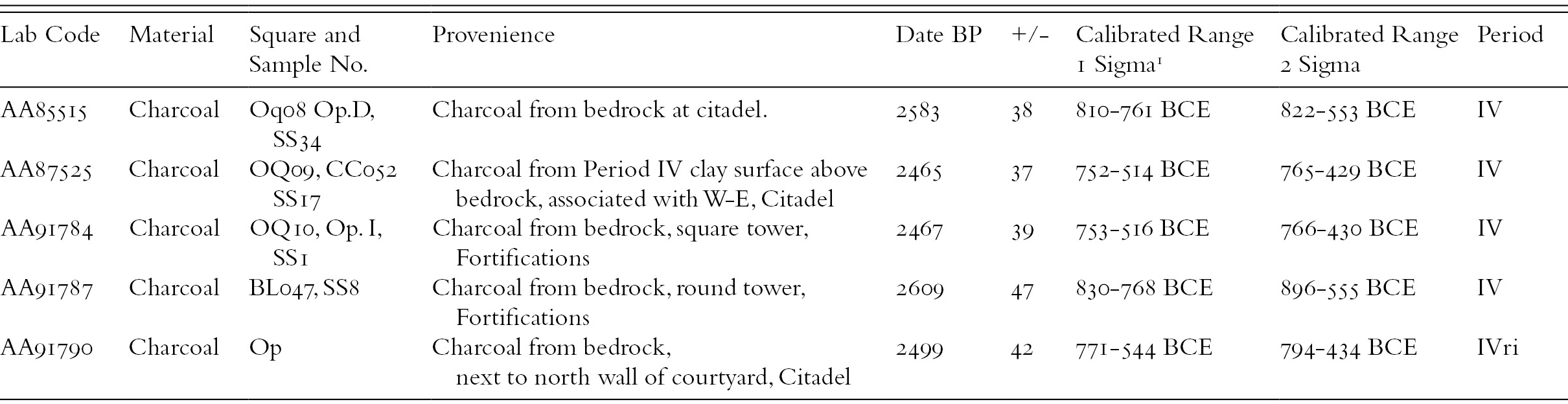
Instead, the fortification walls follow the topography of the slope, which is more typical of local constructions before the rise of Urartu, and their corners are rarely at strict 90 degree angles. Although a pattern of buttressing could be recognized in the western side of the northern fortifications, to the east the wall zigzags with little regularity (Figure 7.4). Masonry styles vary widely across the 215-meter fortification wall; limestone blocks range from carefully shaped to hardly worked and smaller stones are sometimes, but not systematically, used for chinking. This variability is also apparent from an analysis of the wall’s foundations. The wall was built on bedrock, or rather, on top of a layer of fine ash and charcoal that was probably the result of burning off vegetation from the bedrock prior to building. From here, blocks could be laid directly on the bedrock; or a variety of materials could be laid down to level the surface. These could include mudbrick, clay, smaller stones, or a concrete mixture of eroded limestone and pebbles (Ristvet Reference Ristvet, Seyidov and Bakhshaliyev2012). The utter lack of standardized building practices is unusual: it almost seems as if several different individuals were in charge of building different parts of the wall, with no centralized authority to direct efforts (Morgan Reference Morgan2012). Although such construction would be typical of EIA fortresses, C14 dates taken from the foundations of the fortification walls indicate an MIA date (Table 7.1; also Ristvet et al. Reference Ristvet, Seyidov and Bakhshaliyev2012).

7.4. Plan of the northern fortifications.
Table 7.1. Oğlanqala Period IV Radiocarbon Dates
| Lab Code | Material | Square and Sample No. | Provenience | Date BP | +/− | Calibrated Range 1 Sigma1 | Calibrated Range 2 Sigma | Period |
|---|---|---|---|---|---|---|---|---|
| AA85515 | Charcoal | Oq08 Op.D, SS34 | Charcoal from bedrock at citadel. | 2583 | 38 | 810-761 BCE | 822-553 BCE | IV |
| AA87525 | Charcoal | OQ09, CC052 SS17 | Charcoal from Period IV clay surface above bedrock, associated with W-E, Citadel | 2465 | 37 | 752-514 BCE | 765-429 BCE | IV |
| AA91784 | Charcoal | OQ10, Op. I, SS1 | Charcoal from bedrock, square tower, Fortifications | 2467 | 39 | 753-516 BCE | 766-430 BCE | IV |
| AA91787 | Charcoal | BL047, SS8 | Charcoal from bedrock, round tower, Fortifications | 2609 | 47 | 830-768 BCE | 896-555 BCE | IV |
| AA91790 | Charcoal | Op | Charcoal from bedrock, next to north wall of courtyard, Citadel | 2499 | 42 | 771-544 BCE | 794-434 BCE | IVri |
1 Calibrated using OxCal 4.2
Furthermore, Oğlanqala‘s administrative quarter, located at the highest point of the mountain, is also unlike Urartian palaces, which tend to be single buildings that combine economic, political, and religious functions, as at Erebuni, Argishtihinili, and Karmir Blur (Smith Reference Smith2003). There are at least two discrete buildings in the fortified area encompassing 1.2 hectares that define the palace district (Figure 7.5). The main administrative building, to the north, occupies 4,000 square meters, while to the south there is another monumental building, constructed of the same Cyclopean blocks. Another large building, perhaps a temple, constructed of imported basalt blocks, that has been recognized from magnetometry survey may also date to this phase (Sternberg et al. Reference Sternberg, Dee, Johnson, Ristvet, Bakhshaliyev, Scott, Braekmans, Carremans and Degryse2012). The existence of multiple administrative buildings may indicate division of authority between different institutions, perhaps with separate spheres of authority.

7.5. Aerial view of the northern administrative building, at the citadel of Oğlanqala.
The northern administrative building covers an area of about 4,700 square meters, 1,900 of which have been sampled in excavations.4 The same construction techniques used on the fortification walls were employed here. The palace foundations were built from roughly worked limestone blocks ranging from 35 to 90 centimeters, which were founded on a surface applied to bedrock made up variously of mudbrick, pebbles, or cobbles. Like the fortification walls, the citadel walls were wide (between 1.7 and 2.5 meters) and had a rubble core (Figure 7.6). Unlike the fortifications, however, the walls of the building were straight, with the exception of a square buttress to the southeast, and possibly a similar, badly eroded feature to the southwest. They did not, however, reveal evidence of the type of regular buttressing usually exhibited by Urartian constructions, although multiple C14 dates retrieved from the foundations indicate that this palace was constructed during the MIA (Ristvet et al. Reference Ristvet, Seyidov and Bakhshaliyev2012: table 2). A possible gate on the citadel’s west side probably provided access to a large courtyard surrounded by storage rooms (Ristvet Reference Ristvet, Seyidov and Bakhshaliyev2012: 45–7). Within this building, recovered material also differs from that found in Urartian fortresses. Seals, metalwork, Urartian weaponry, and even typical Urartian pottery are absent or found in small quantities.

7.6. Western wall of the northern administrative building.
The discussion so far has indicated that elites at Oğlanqala pointedly ignored many aspects of Urartian material culture; however, they did choose to adopt certain Urartian materials and indeed practices, particularly writing and perhaps administration more generally. Although we have evidence thatcuneiform was present here, writing was used in a more restrictive context at Oğlanqala than in Urartu more generally. The paucity of inscriptions in Naxçɪvan (discussed previously) makes this area quite different from neighboring regions that were incorporated into Urartu. In the Ararat Valley, for example, there are more than one hundred rock-cut inscriptions from at least seventeen different sites, and in northwestern Iran, they are found at thirteen sites (Salvini Reference Salvini2008). Their absence at the fortress of Oğlanqala is particularly striking, especially given the large area of the fortress that has been excavated and the intensive survey of the remaining surface architecture (Ristvet Reference Ristvet, Seyidov and Bakhshaliyev2012). Most large Urartian fortress sites have inscriptions commemorating military campaigns and imperial constructions.
Despite the absence of monumental inscriptions, writing does seem to have been used for administration, however. Indeed, we consider this building public for a number of reasons: its monumentality; its placement at the highest point of the site; but perhaps most especially, because of the large quantity of large storage jar sherds found in its ruins, testifying to the importance of collecting, storing, and possibly redistributing goods here. Six fragments of cuneiform-inscribed vessels have been recovered from excavations within the palace. Most of these belong to large pithoi and record vessel capacity, attesting to use of writing in an economic capacity. The shoulders of these pithoi were decorated with an incised arrow pattern, which is unattested outside Oğlanqala. Gopnik hypothesizes that this decoration mimics cuneiform andmay emphasize the significance of this imported system (Ristvet Reference Ristvet, Seyidov and Bakhshaliyev2012). Writing here probably works not just to record information, but as a symbol of power, an exotic good. The one other piece of inscribed material found in Naxcivan supports this interpretation. This is a brick, inscribed with pseudocuneiform (Figure 7.7). The symbols on the brick mimic cuneiform wedges, but they are not intelligible. The use of pseudowriting probably emphasizes the importance of the representation of writing, as a foreign symbolic system, alongside its actual incorporation into economic life, as the inscribed pithoi demonstrate.

7.7. Inscribed brick with pseudowriting, found during road construction in Naxçɪvan.
Studies of Urartian toponyms have proposed that many of the polities that Urartu fought were tribal confederacies; perhaps the best-known example is the Etiuni/Etiuhi, who were at home near Lake Sevan (Biscione et al. Reference Biscione, Smith and Rubinson2003a; Smith Reference Smith2005). It is quite probable that Oğlanqala was the center of a similar confederation that consolidated precisely in order to counter Urartian raids into this area. Indeed, positing that the fortress served a confederation, perhaps several unified agropastoralist groups that maintained a certain degree of autonomy, may explain the seeming lack of standardization in the construction of the fortification walls and the presence of multiple administrative buildings at the site. It is possible that Oğlanqala was not the seat of one king, the way that Urartian royal cities were; instead, it may have served as a power base for multiple powerful individuals and their followers, all of whom were responsible for building and maintaining this place.
Economic Transformations in Craft Production and Trade
The evidence from the pithoi illustrates an interesting point with regard to the Oğlanqala‘s relationship with Urartu. If we consider merely the evidence for political responses to Urartu, we might conclude that this area was concerned mostly with autonomy or resisting imperial advances. However, economic data indicate that despite the emphasis on nonconformity, the Şərur Plains were affected by and integrated into a larger Urartian economy. Indeed, craft production and trade were vital areas of negotiation between these two polities.
We see this most clearly in an analysis of pottery production that documents important changes in the organization of production and the economic networks in which Oğlanqala was embedded. Fishman has undertaken a comprehensive material analysis of ceramic production in this region. While her investigation is not yet complete, the results of her pilot study are intriguing. During the EIA (Oğlanqala V), petrographic analysis of twenty-seven sherds from Oğlanqala and a nearby kurgan showed that nearly all of the ceramics (n = 23, 85 percent) from this period belonged to the andesite temper petrogroup and were made of “a low-fired clay tempered with andesite, limestone, and a range of intermediate volcanic inclusions,” which probably came from the nearby Arpaçay riverbed (Fishman Reference Fishman, Ristvet, Gopnik and Bakhshaliyevn.d.). Of the four samples that did not fit into this group mineralogically, three were made of similar low-fired, tempered clay, leaving only one outlier (Figure 7.6). The remarkable consistency revealed by the petrography is correlated with the stylistic uniformity of these ceramics, which are burnished gray ware vessels, often bowls, plates, and jars with some incised decoration. These ceramics are similar in style to the gray ware horizon characteristic of the EIA throughout the broader region of the southern Caucasus and Northwest Iran (Young Reference Young1965; French and Summers Reference French and Summers1994; Sagona Reference Sagona1999; Sevin Reference Sevin1999). The homogeneity of the samples from this period suggests that local artisans employed a limited range of local clays and used similar clay processing and firing techniques in order to produce ceramics that fit within a regional stylistic tradition.
In contrast, petrographic and stylistic analyses of ceramics from the MIA levels at the citadel (Oğlanqala IV) show major changes in ceramic production techniques and stylistic choices. Although only fifteen sherds from this phase were examined, their heterogeneity makes them different from the earlier, period V samples. This sample consists of three petrogroups, two pairs, and two loners, indexing diversification in patterns of production and trade. The best represented group (n = 7), the “andesite calcareous,” comprises the majority of locally made bowls and jars with red and tan slips. Unlike the most common petrogroup in Period V, the “andesite-tempered group,” these ceramics were made of clay with naturally coarse grained inclusions fired at somewhat higher temperatures in an oxidizing atmosphere. The existence of some minor mineralogical differences between the two groups may suggest the use of different local clay sources, in addition to the obvious differences in clay processing and firing. Clearly, the shift from gray burnished to red burnished ceramics, which occurred throughout the area, was not merely a matter of changing finishing treatments, but likely corresponded to significant changes in several stages of ceramic production and quite probably in the organization of this and possibly other industries. Such a marked change in technological styles, coincident with the fortification of the citadel, is probably an indicator of a sociopolitical shift, perhaps related to increasing regional demand for ceramics (and the goods they once held).
In addition to the changes in the production of these common wares, petrography and stylistic analysis both suggest the presence of imported ceramics and raw materials at the citadel, providing more evidence for changing economic patterns. Petrographic analysis of four dark brown mottled ware bowls, one of the most common wares at imperial Urartian sites, revealed that these vessels were made of three distinct nonlocal fabrics, in addition to the common local andesite calcareous ware. Although the results are preliminary, the presence of bowls with such different signatures suggests that Oğlanqala was probably tied into a variety of trade networks. Moreover, the presence of a locally made brown mottled bowl indicates that local artisans may also have produced these vessels, providing evidence for complex local engagement with foreign goods. This ware makes up a very small part of the assemblage (7 percent or 57 of 863 sherds), perhaps indicating that these bowls were valuable, whether of foreign origin or local production.
In addition to these imports, sherds belonging to not more than five bowls of classic red-polished Urartian palace ware were found on the citadel, probably attesting to a similar pattern of imports supplemented with local production. Several of these fragments are too fine for petrographic analysis, but analysis of a thin section of one sherd found that despite its unusual fineness, it was made locally. Polished red ware ceramics are almost as rare at Oğlanqala as the genuine palace ware that it appears to be mimicking, again perhaps indicating the value of this scarce good. In addition to this evidence for imported ceramics, the temper used for the pithoi that were once stored in the administrative building was also probably imported, as the isolated trachyandesite used as temper in these vessels is not found in the valley (Fishman Reference Fishman2012; Reference Fishman, Ristvet, Gopnik and Bakhshaliyevn.d.).
In short, the rise of the Urartian Empire likely affected local economic systems in several different ways. It probably provided new markets for goods and thus affected craft specialization and other spheres of economic production, while also providing access to new goods, particularly to elites at the site. The evidence suggests that there were probably many opportunities for negotiation on a range of levels, including possibly between different potters, given the changes in production processes and the use of new temper from different locales. Other economic effects are harder to quantify. Violence and raiding probably affected the livelihoods of farmers and shepherds directly and perhaps also indirectly, since the authorities at Oğlanqala may have needed to increase taxes to fund a military response or to redistribute grain in times of need.
Discussion
I argue that the people who commissioned the monumental architecture at Oğlanqala responded to the challenges and opportunities created by the rise of Urartu in myriad ways. Perhaps in response to persistent violence, they built fortified settlements at higher elevations and sought to control a highland area, rather than the fertile plain, which they may have ceded to Urartu. They employed architectural styles that emphasized their continuity with the local past, in opposition to an Urartian ideology that emphasized novelty and standardization. In a border region, close to traditional Urartian fortresses, this would have been a significant way to mark resistance and independence. Oğlanqala was not alone in this, as other centers on Urartu’s borders in Armenia and Iran such as Horom and Tsovinar emphasized continuity with the past. At the same time, negotiation was crucial to political and economic strategies. The limited presence of cuneiform shows that the Oğlanqala’s ruling class did adopt certain imported symbols and administrative technologies. Evidence of changes in pottery production and import networks indicates that even if Oğlanqala remained independent, it participated in larger economic changes in the region, which were probably driven in a large part by the desire of Urartu for external goods.
In the absence of written records, Oğlanqala‘s exact relationship to Urartu is difficult to establish. It may be that this center’s supremacy in the Şərur Plains was short-lived, and that it was destroyed and abandoned after the establishment of Verachram, perhaps as part of the Urartian conquest of the region. It is also possible that it was occupied simultaneously with Verachram as an independent polity, and that its position meant that it controlled little of the southern part of the plain, but instead looked north to the Selim Pass. Or Oğlanqala may have persisted as a center within Urartu, a client state, perhaps subordinate to Verachram but with its own limited sphere of authority.
Regardless of which scenario turns out to be the most likely, this research in the Şərur Plains has implications for reconstructions of Urartu and of the MIA political landscape through the lenses of violence, negotiation, and resistance. First, our analysis of violence and negotiation has shown that Urartu’s military and economic effects extended beyond the empire’s perimeter marked by the state assemblage; military campaigns had an impact on settlement patterns, while changing trade routes and potentially new markets affected elite interaction and craft production. Second, evidence of shifts in settlement patterns imply the importance of external threats here in political centralization, indicating the importance of resistance in archaeological analysis. The rise of Urartu has often been understood as partly a response to Assyrian aggression; it is possible that Urartu itself helped to create various smaller centralized polities along its frontiers. Third, the evidence for an alternative political structure at Oğlanqala, namely a highland confederacy not controlled by a single ruler, indicates that there may have been many different political systems in operation in the highlands, existing either beneath Urartian centralization or alongside it. Finally, the unusual archaeological record at Oğlanqala reveals something of the cultural and political faultlines that probably ran throughout the empire and were clearest on the frontiers. As we have long known, Urartu incorporated an extraordinary number of different peoples, including many resettled deportees (Zimansky Reference Zimansky, Kroll, Gruber, Hellwag, Roaf and Zimansky2012); as we move toward excavating more settlements, the techniques used for integrating this diversity will become clearer. Future research in the Șərur Plain will focus on elucidating these patterns through systematic excavation and survey of the settlement around the site.