


The development of Maya society during the Preclassic has been a trending topic in Maya scholarship during the past decade, and, in particular, the Middle Preclassic (1000–400/300 b.c.) has been the subject of numerous new investigations (Andrews V et al. Reference Andrews, Wyllys, Bey, Gunn, Kathryn Brown and Bey2018; Braswell Reference Braswell and Braswell2012; Brown and Bey Reference Brown, Bey, Brown and Bey2018; Estrada-Belli Reference Estrada-Belli2011, Reference Estrada-Belli, Traxler and Sharer2016; Gallareta Negrón Reference Gallareta Negrón, Kathryn Brown and Bey2018; Garber et al. Reference Garber, Brown, Awe, Hartman and Garber2004; Hansen Reference Hansen, Traxler and Sharer2016; Hohmann et al. Reference Hohmann, Powis, Healy, Brown and Bey2018; Inomata et al. Reference Inomata, MacLellan, Triadan, Burham, Aoyama, Nasu, Munson, Pinzón and Yonenobu2015; Rice Reference Rice2015; Robles Castellanos and Ceballos Gallareta Reference Robles Castellanos, Gallareta, Brown and Bey2018; Triadan et al. Reference Triadan, Castillo, Inomata, Palomo, Méndez, Cortave, MacLellan, Burham and Ponciano2017). This emphasis seems long overdue, as the changes that took place from 1000 to 300/400 b.c. are on an unrivaled scale. The period begins with inhabitants settling down and building permanent communities across the tropical landscape and ends with the rise of state-level political organizations and the emergence of centralized political authority in the form of rulers.
The articles in this special section present data and address specific issues from throughout the Lowlands, revealing the complex nature of the evolution of a complex society in the Maya region. In this article, we examine one aspect of this evolution, the relationship between the development of landesque capital and sociopolitical processes during the Middle Preclassic. The relationship between these two phenomena provides a foundation for understanding many of the transformations that ensued during the Middle Preclassic, as well as a backdrop for the contributions in this section.
WHAT IS LANDESQUE CAPITAL?
Landesque capital was a concept originally proposed by economist Amartya Sen in 1959, defined as investments that increase the yield on parcels of land without replacing labor. According to Sen (Reference Sen1959:280), these investments could include irrigation systems, fertilizers, and pest control. This original definition of landesque capital was expanded in the 1980s by Brookfield (Blaikie and Brookfield Reference Blaikie and Brookfield1987; Brookfield Reference Brookfield, Billinge, Gregory and Martin1984), who emphasized the permanent nature of land improvements and linked them to the notion that social actors (improvers) must be able to hold and control the results of the investment. More recently, scholars such as Clark and Huei-Min Tsai (Reference Clark and Tsai2009) have centered the definition of landesque capital on the power to improve environmental conditions that affect soil fertility, biodiversity, land cover, carrying capacity, resilience, and other dimensions of sustainability. Crucially, these definitions encompass hydraulic systems that captured and stored rainwater, stabilizing water accessibility for both agriculture and consumption (Dunning et al. Reference Dunning, Beach and Luzzadder-Beach2012; see also Wittfogel Reference Wittfogel1957).
Erickson (Reference Erickson, Silverman and Isbell2008) also explored the concept and argued that material landscapes and social processes are both connected to the physical transformations that constitute landesque capital (see also Steward Reference Steward1955). However, Erickson is clear in distinguishing between landesque capital and domesticated landscapes. Both are forms of anthropogenic landscapes, or anthromes, defined as the ecological patterns created by interactions between humans and ecosystems. According to Erickson (Reference Erickson, Balée and Erickson2006:241), domesticated landscape involves “non-genetic, intentional and unintentional practices and activities of humans that transform local and regional environments into productive physically patterned, cultural landscapes.” Domesticated landscapes, then, may be transformed into landesque capital by investments in permanent improvements.
These permanent improvements are a materialization of banked labor—work that is completed in anticipation of payment or rewards later—and can be possessed by the individuals or groups (Fisher and Feinman Reference Fisher and Feinman2005:64). This tenurial relation provides an incentive for allocating labor to such investments. Investments may be major, such as the construction of a reservoir, and represent systemic changes within the environment.
However, investments may also be minor and accretional, representing incremental changes in an environment. One example of incremental change involves soil enhancement and the improvements in irrigation systems carried out by smallhold farmers working within the ejido systems in Mexico, under which usufruct rights to the lands are conveyed by continual use (Doolittle Reference Doolittle1984, Reference Doolittle2001). Another case involves the creation of terra preta (Amazonian Dark Earth), the gradual accumulation of organic material in soils as a result of long-term food-processing practices by both hunter-forager and agricultural communities (Neves et al. Reference Neves, Petersen, Bartone, da Silva, Lehmann, Kern, Glaser and Woods2003:41). Significantly, while many incremental changes are intentional, this is not always the case (Neves et al. Reference Neves, Petersen, Bartone, da Silva, Lehmann, Kern, Glaser and Woods2003:35). Therefore, it is important to recognize that intentionality is not necessarily inherent in processes that create landesque capital.
Permanent investments in land that result in greater and more sustained yields or increased subsistence security qualify as capital as they provide benefits to social actors (investors) that exceed the labor banked within the investment. More specifically, landesque capital, such as irrigation systems and anthropogenic soils, qualifies as capital explicitly because it is integral to economic exchange and wealth accumulation (Håkansson Reference Håkansson, Håkansson and Widgren2014; Hornberg et al. Reference Hornborg, Alf, Bogadóttir, Håkansson and Widgren2014). Significantly, however, in contrast to capital as defined in Marxist economics, landesque capital remains embedded within culturally specific symbolism and local institutions in pre-capitalist economies. According to Blaikie and Brookfield (Reference Blaikie and Brookfield1987), skills, technology, and labor all contribute to innovations that create enduring land improvements, landesque capital. As each of these processes is culturally contingent, it is not possible to disengage the development of landesque capital from the evolution of political, religious, and social institutions (see Erickson and Walker Reference Erickson, Walker, Snead, Erickson and Darling2009). Indeed, a positive correlation between intensifying landesque capital and increasing sociopolitical complexity appears to have been strong.
This relationship is best illustrated in a recent a study conducted among Austronesian-speaking social groups (Sheehan et al. Reference Sheehan, Watts, Gray and Atkinson2018). Results of this study suggest that intensification of landesque capital investment and increasing hierarchy promoted each other, perhaps as part of a feedback loop. However, neither was a determinant of the other (Widgren Reference Widgren, Hornborg, McNeill and Martinez-Alier2007:72). Therefore, Oliver Sheehan and his colleagues found that while increasing investments in landesque capital and increasing social stratification co-evolved, they were not mutually dependent (Sheehan et al. Reference Sheehan, Watts, Gray and Atkinson2018:3632).
Accordingly, the relationship between landesque capital and sociopolitical complexity may be characterized as co-evolutionary, yet the nature of the entanglement remains culturally and historically contingent. For example, in their study of historic societies in nineteenth-century East Africa, Håkansson and Widgren (Reference Håkansson and Widgren2007:245) generally concluded that investments resulting in landesque capital occurred if agriculture were the primary source for long-term wealth accumulation, regardless of the presence of hierarchical political systems. However, external networks and local contingencies influenced specific choices regarding investments in enduring or short-term extraction strategies. Likewise, Morrison (Reference Morrison, Håkansson and Widgren2014) argues that political and religious institutions played a significant role in structuring Middle period agrarian landscapes in South India. Specifically, she argues that mid-level political elites sponsored the construction of reservoirs in areas with very poor investment returns, in part because of the ritual and political associations and prestige they could accrue through such patronages (Morrison Reference Morrison2010).
Bearing in mind such definitions, we contend that accretional and unintentional practices, along with substantive and intentional acts, created features of landesque capital that directly sustained populations, such as agricultural terraces or reservoirs. In addition, we argue that landesque capital also encompassed physical spaces that provided a venue for social processes, while also enhancing sustainability. Examples of spaces such as these would include civic-ceremonial complexes designed to direct the flow of water into reservoirs. Landesque capital, then, not only augmented potential yields and increased subsistence security in an environment, but also supported the ontological foundations of sustainable practices.
In the following pages, we will explore entanglement between landesque capital and sociopolitical complexity in the Maya Lowlands during the Middle Preclassic to better understand the nature of the significant transformations that occurred during this period.
EARLY ACCRETIONAL CHANGES IN THE MAYA LOWLANDS
Widgren (Reference Widgren, Hornborg, McNeill and Martinez-Alier2007) states that given the enduring nature of landesque capital, people continue to benefit from past improvements. Indeed, the management of biomes prior to the Middle Preclassic influenced subsequent investment choices and practices. These earlier acts were incremental and cumulative, taking place over a long period of time and resulting in significant modifications that continued to benefit inhabitants of the Lowlands during the Middle Preclassic.
The notion that accretional changes led to major adaptations is not new in the Maya Lowlands: it was introduced by Scarborough (Reference Scarborough, Scarborough and Isaac1993, Reference Scarborough, Costanza, Graumlich and Steffen2007) to describe the development of water management systems. Scarborough (Reference Scarborough, Costanza, Graumlich and Steffen2007:55) states that only slow, incremental modifications were possible in the fragile tropical environment, as larger or rapid changes would result in disruptions to the natural flow of nutrients and energy. The concept of accretional modification was later employed by Dunning (Dunning et al. Reference Dunning, Rue, Beach, Covich and Traverse1998) to characterize the evolution of agricultural terracing. In this section, we examine accretional changes during the Preceramic period that resulted in permanent land investments, which were advantageous for generations.
The Preceramic period in the Maya Lowlands has been identified as dating to 3400–1200/1000 b.c. (Andrews and Robles Castellanos Reference Andrews, Robles Castellanos, Brown and Bey2018; Iceland Reference Iceland1997, Reference Iceland and Powis2005; Lohse Reference Lohse2010; Lohse et al. Reference Lohse, Awe, Griffith, Rosenswig and Valdez2006), while the Initial/Early Formative in Mesoamerica dates from 2000 to 1000 b.c. (Doering Reference Doering and Smith2014; Grove Reference Grove and Carrasco2001; Pool Reference Pool2007). During these periods, evidence throughout the Maya Lowlands suggests that aceramic, mobile populations occupied the same landscapes prior to the “settling down” of communities (Lohse Reference Lohse2010; Lohse et al. Reference Lohse, Awe, Griffith, Rosenswig and Valdez2006). Paleoenvironmental studies (Beach et al. Reference Beach, Luzzadder-Beach, Cook, Dunning, Kennett, Krause, Terry, Trein and Valdez2015:11, Reference Beach, Luzzadder-Beach, Krause, Guderjan, Valdez, Fernandez-Diaz, Eshleman and Doyle2019; Cowgill and Hutchinson Reference Cowgill and Hutchinson1963) and pollen analyses suggest that the first significant human-influenced landscape modifications in the region took place before 2000 b.c., correlated with the emergence of horticultural practices (Leyden Reference Leyden2002; Lohse Reference Lohse2005) in central Peten (Cowgill and Hutchinson Reference Cowgill and Hutchinson1963; Islebe et al. Reference Islebe, Hooghienstra, Brenner, Curtis and Hodell1996; Vaughan et al. Reference Vaughan, Deevey, Garrett-Jones and Pohl1985; Wahl et al. Reference Wahl, Byrne, Schreiner and Hansen2006), the southeastern zones (Rue Reference Rue1989; Rue et al. Reference Rue, Webster and Traverse2002), and northern Yucatan (Whitmore et al. Reference Whitmore, Brenner, Curtis, Dahlin and Leyden1996).
The Early Preceramic
The early phase of the Preceramic dates from 3400 to 1500 b.c. and is characterized by mobile lifeways and the beginnings of horticulture, particularly maize and manioc cultivation (Andrews and Robles Castellanos Reference Andrews, Robles Castellanos, Brown and Bey2018; Iceland Reference Iceland1997, Reference Iceland and Powis2005; Lohse Reference Lohse2010; Rosenswig Reference Rosenswig2015). Isotopic evidence from the bones of individuals recovered from rock shelters in southern Belize indicates that from 7600 to 2700 b.c., maize was already a minor part of the diet, which consisted primarily of plants and animals from a C3-dominated neotropical forest (Kennett et al. Reference Kennett, Prufer, Culleton, George, Robinson, Trask, Buckley, Moes, Kate, Harper, O'Donnell, Ray, Hill, Alsgaard, Merriman, Meredith, Edgar, Awe and Gutierrez2020). C3 pathways for carbon fixation are used by most trees, shrubs, and herbs in lowland tropical environments. Cultigens that use a C3 pathway include squash (Cucurbita spp.) and manioc (Manihot esculenta).
C4 pathways are used by many tropical grass species, including maize, and some other plants in warm and arid environments. The first evidence that maize constituted an important component in the diet (defined as more than 25 percent of total diet) occurs between 2750 and 2050 cal b.c. Overall, Kennett and colleagues (Reference Kennett, Prufer, Culleton, George, Robinson, Trask, Buckley, Moes, Kate, Harper, O'Donnell, Ray, Hill, Alsgaard, Merriman, Meredith, Edgar, Awe and Gutierrez2020) deployed a multivariate analysis of δ 15Ncollagen, δ 13Ccollagen, and δ 13Capatite on burials recovered in rock shelters. Because the study included samples from the Paleolithic through the Classic periods, it allowed for a contextualization of the individuals dated to the Early Preceramic and demonstrated the transition from a mixed subsistence diet to one in which maize provided about 30 percent of total diet (Kennett et al. Reference Kennett, Prufer, Culleton, George, Robinson, Trask, Buckley, Moes, Kate, Harper, O'Donnell, Ray, Hill, Alsgaard, Merriman, Meredith, Edgar, Awe and Gutierrez2020:6). These data are consistent with evidence for increased forest burning and clearing, maize cultivation, and erosion across the Maya Lowlands, suggesting a greater commitment to maize horticulture between 2550 and 2050 cal b.c. In Belize, this marked increase in forest clearance began around 2500 b.c. (Pohl et al. Reference Pohl, Pope, Jones, Jacob, Piperno, deFrance, Lentz, Gifford, Danforth and Josserand1996). Pollen in sediment cores from Lake Puerto Arturo, on the western edge of the Central Karstic Uplands in the northern Peten, also show deforestation-related taxa from ca. 4000–2000 b.c., with maize pollen recovered from a level that dates to 2650 b.c. (Wahl et al. Reference Wahl, Byrne, Schreiner and Hansen2006, Reference Wahl, Byrne, Schreiner and Hansen2007). In addition, one early date of 2910–2880 cal b.c. from Yaxnohcah in a secondary context suggests that mobile groups in this region may also have burned the forest for extensive horticulture. Simultaneously, the starch grain and phytolith analysis of Preceramic tools in northern Belize has identified maize, along with numerous other species, such as Capsicum (pepper), manioc, Fabaceae (bean), Cucurbitaceae (squash), and a type of unidentified root/tuber, perhaps macal (taro) (Rosenswig et al. Reference Rosenswig, Pearsall, Masson, Culleton and Kennett2014). Soil/sediment and pollen evidence from Cobweb Swamp demonstrates habitat disturbance, along with the appearance of cultigens, including manioc, by 3000 b.c. and maize by 2500 b.c. (Jacob Reference Jacob1995; Jones Reference Jones1991, Reference Jones1994). Pollen research at Cob Swamp near the Rio Hondo also confirms evidence for cultigens between 3400 and 3000 b.c., with maize appearing after 2400 b.c. (Pohl et al. Reference Pohl, Pope, Jones, Jacob, Piperno, deFrance, Lentz, Gifford, Danforth and Josserand1996).
Other material evidence of Early Preceramic occupation has been especially robust in northern Belize. Located along and near Freshwater Creek, the sites of Caye Coco and Fred Smith revealed large horizontal occupations, 150 m2 and 400 m2, respectively. Excavations at Caye Coco also revealed two pits and a posthole carved into bedrock, along with the material remains of worked oyster shell (Rosenswig and Masson Reference Rosenswig and Masson2001). Three charcoal samples from the Caye Coco pit features yielded radiocarbon dates spanning from 6320 to 4610 cal b.c. and from 790 to 740 cal b.c. (Rosenswig et al. Reference Rosenswig, Pearsall, Masson, Culleton and Kennett2014). Even though Rosenswig and colleagues (Reference Rosenswig, Pearsall, Masson, Culleton and Kennett2014:312) acknowledge that the early dates may be a result of the “old wood” effect, the recurrent occupation of this site for several millennia is remarkable.
Rosenswig and Masson (Reference Rosenswig and Masson2001) also recovered numerous lithic tools associated with early horticulture and forest clearing, including a plano-convex biface from Caye Coco Pit #2, two bifaces from disturbed surface contexts at the Fred Smith site, an expedient biface from the Patt Work site, also from a disturbed context, a heavily used uniface from Laguna de On, and a constricted adze from Doubloon Bank Lagoon.
At Colha, also in northern Belize, excavations revealed a preceramic occupation adjacent to Cobweb Swamp (Lohse et al. Reference Lohse, Awe, Griffith, Rosenswig and Valdez2006). Several constricted adzes were recovered dating to 3000–1000 b.c. Additional investigations in northern Belize have recovered a constricted adze dating to 1275 b.c. along the Rio Hondo, and a Lowe point dating to 2210 b.c. from Pulltrouser Swamp (Pohl et al. Reference Pohl, Pope, Jones, Jacob, Piperno, deFrance, Lentz, Gifford, Danforth and Josserand1996).
The Late Preceramic
The Late Preceramic phase dates from 1500 to ca. 1200/1000 b.c. and is completely encompassed within the Early Formative period (1500–1000 b.c.) in Mesoamerica (Pool Reference Pool2007:7). This period appears to have been a transitional period distinguished by widespread horticulture, increase in the number of sites, early ceramics, and an increase in lithic tools associated with horticulture, including constricted adzes (Lohse Reference Lohse2010). Indeed, the production of the constricted adze is one of the hallmarks of this period. Concentrated in northern Belize, but found in northwestern Belize as well as in Actun Halal (Lohse Reference Lohse2005, Reference Lohse2008, Reference Lohse2010:327), these specialized tools were associated with wood cutting and chopping, and other horticultural activities from 1500 to 1000 b.c. (Gibson Reference Gibson, Hester and Shafer1991; Hudler and Lohse Reference Hudler and Lohse1994; Lohse Reference Lohse2008). Other indicators of change during this period arise in central Belize, where an absence of macro-blade production from 2000 to 1000 b.c. (Awe et al. Reference Awe, Ebert, Stemp, Brown and Garber2021) signals technological developments associated with changing subsistence practices or population movement at this time.
Pollen samples from cores taken throughout the Maya Lowlands demonstrate an increase in forest clearance after ca. 2000 b.c. (Leyden Reference Leyden2002:94). In the Peten Lakes region, pollen data from Lake Salpeten clearly illustrate that very little forest remained adjacent to the lake by about 2000 b.c. The Petenxil cores (Tsukada Reference Tsukada, Cowgill and Hutchinson1966) and the Quexil core (Vaughan et al. Reference Vaughan, Deevey, Garrett-Jones and Pohl1985) also indicate Zea mays cultivation and forest clearance between 2000 and 1000 b.c. In the Petexbatun region, a core from Lake Tamarandito provides evidence of the emergence of horticulture beginning around 2000 b.c.: grass pollen (gramineae) increases, while deciduous tree pollen (Moraceae-Urticaceae and Combretaceae) decreases (Dunning et al. Reference Dunning, Rue, Beach, Covich and Traverse1998). Finally, in Belize, pollen studies from cores taken in the Laguna de Cocos, near Albion Island, also indicate forest clearance beginning in 2000 b.c. (Hansen Reference Hansen and Pohl1990).
Several isotopic studies of samples from the Maya Lowlands of northern and southern Belize and the Soconusco region of the Pacific Coast show the transition of maize from a minor part of the diet to a dietary staple between 2000 and 1000 b.c. (Blake et al. Reference Blake, Chisholm, Clark, Voorhies and Love1992; Kennett et al. Reference Kennett, Prufer, Culleton, George, Robinson, Trask, Buckley, Moes, Kate, Harper, O'Donnell, Ray, Hill, Alsgaard, Merriman, Meredith, Edgar, Awe and Gutierrez2020; Smalley and Blake Reference Smalley and Blake2003; Tykot et al. Reference Tykot, van der Merwe, Hammond and Orna1996). The study of 23 individuals dating from 2000–1000 b.c. recovered from rock shelters in southern Belize demonstrate the increased importance of maize in daily diets. In this sample, more than 50 percent of protein came from the consumption of C4 plants or animals eating C4 plants, a frequency that overlaps isotopically with commoner populations during the Classic period (Kennett et al. Reference Kennett, Prufer, Culleton, George, Robinson, Trask, Buckley, Moes, Kate, Harper, O'Donnell, Ray, Hill, Alsgaard, Merriman, Meredith, Edgar, Awe and Gutierrez2020).
In northern Peten, specifically the Central Karstic Uplands, evidence for the Preceramic occupation of the region is mounting. Beginning in 1450 b.c., there is an abrupt rise in grasses and weeds and an accelerated decline in forest taxa (Wahl et al. Reference Wahl, Byrne, Schreiner and Hansen2006). In addition, carbon samples from construction fill of the earliest deposits at Nakbe have yielded radiocarbon dates clustered between 1400 and 1000 b.c. (Hansen Reference Hansen and Houston1998:55–56, Table 1, Reference Hansen and Powis2005:58, 62, Table 5.1). Likewise, three radiocarbon dates from the early deposits at Yaxnohcah also cluster between 1500 and 1280 b.c. These carbon samples were retrieved from construction fill, and therefore, it is highly likely that they reflect early burning associated with deforestation in the region near the Bajo Tomatal, prior to the appearance of permanent settlements or perhaps their ephemeral outset. Similar spans were also noted in three radiocarbon dates from Betz Landing, northern Belize, dating to 1500–900 b.c. (Zeitlin Reference Zeitlin1984).
Conspicuously absent is evidence of preceramic occupations in the northern Yucatan. One of the only radiocarbon dates associated with this period was recovered from Loltun Cave. A carbon sample dated to 1840 b.c. was recovered from the interstitial area between a ceramic level (El Toro, Level VII) and an aceramic level (El Toro, Level VIII). Level VIII contained 21 crude flaked tools, including used and retouched flakes, scrapers, gravers, knife-gravers, denticulated tools, and one point, and two core fragments, as well as bones of an extinct horse species. Archaeologists have concluded that the levels in these excavations were heavily mixed; however, the Early Formative date does suggest the presence of early populations in this region (Andrews and Robles Castellano Reference Andrews and Robles Castellanos2004, Reference Andrews, Robles Castellanos, Brown and Bey2018).
Creation of Landesque Capital through Accretional Practices
During the Preceramic and Early Formative periods, the creation of landesque capital resulted from accretional investments. Forest clearings were burned to expand areas for horticulture, which also resulted, at least initially, in soil enrichment—though, problematically, it also initiated accelerated soil erosion in some areas. It is likely that the practice of intensively managed mixed gardens (individualized mixes of seed, root, and tree crops) adjacent to residences was initiated from the outset of sedentism or semi-sedentism. Such gardening was dependent on the careful management of soil to limit erosion, maintain open space, limit weed competition, and maintain or enhance fertility over time—likely including intentional addition of organic matter in the form of human and kitchen waste, green mulching, and occasional re-burning after fallow (Evans et al. Reference Evans, Vis, Dunning, Graham and Isendahl2021). However, with the progressive removal of forest cover, the capture of both inorganic dust and ash from nearby burning, both integral to higher phosphorous levels, is reduced, and soil fertility declines sharply (Das et al. Reference Das, Lawrence, D'Ordorico and DeLong2011).
The early inhabitants of the Maya Lowlands, therefore, established a delicately balanced cultivated landscape that eventually included significant amounts of forest cover within a mosaic of gardens and fields (see Dunning et al. Reference Dunning, Beach and Luzzadder-Beach2012, Reference Dunning, Beach, Graham, Lentz, Luzzadder-Beach and Reid2018, Reference Dunning, Beach, Luzzadder-Beach, Hutson and Arden2020; Lentz et al. Reference Lentz, Dunning, Scarborough, Magee, Thompson, Weaver, Carr, Terry, Islebe, Tankersley, Sierra, Jones, Buttles, Valdez and Ramos2014; Turner and Sabloff Reference Turner and Sabloff2012). Incremental investments in soils acted on cultigens, such as maize and manioc, resulting in higher yields (see Kirkby Reference Kirkby1973:126), and by 2000 b.c. maize was a dietary staple in southern Belize (Kennett et al. Reference Kennett, Prufer, Culleton, George, Robinson, Trask, Buckley, Moes, Kate, Harper, O'Donnell, Ray, Hill, Alsgaard, Merriman, Meredith, Edgar, Awe and Gutierrez2020). Also, innovations in lithic tools, such as the appearance of constricted adzes, allowed for improvements in horticulture practices. Given the longevity of horticultural and agricultural systems that developed in the Maya Lowlands, this system likely had its roots in the formation of sedentary communities, and the knowledge derived from generations of experimentation expanded from early gardening to more extensive forms of farming. These early, carefully managed soil plots, although largely invisible today (except perhaps in the form of patchwork soil phosphate enrichment), were a form of landesque capital, passed down across generations and expanded accretionally throughout the landscape as populations and sedentism increased.
FROM GARDENING TO FARMING
Accretional modifications during the Preceramic period allowed for a pronounced shift at the beginning of the Middle Preclassic. During the period 1000–800 b.c., inhabitants of the Lowlands transitioned from horticulturalists/foragers to agriculturalists, reinforcing the importance of landesque capital in the Lowlands. In this section, we will discuss evidence for this transition and its consequences with a focus on landscape modifications and the built environment.
Environmental Proxies
Evidence for the transition to farming is indicated by numerous studies of environmental data. Geochemical analyses of soils from throughout the Maya Lowlands show a rise in phosphorous levels in soils after 1000 b.c. Higher phosphorous levels are considered a proxy for increased human activity, but the correlation is not always directly associated with agricultural intensification. Increased phosphorous in archaeological soils typically results from domestic activities. However, higher levels of phosphorous are noted in garden areas with human and other waste and in sediments derived from recently burned fields. Also, higher phosphorous levels in lake sediments are attributed to increases in human population density—and a concomitant increase in waste—in the catchment area, as well as rapid erosion and transport of topsoil into bajos and lake basins due to expanded vegetation clearance (e.g., Beach et al. Reference Beach, Luzzadder-Beach, Cook, Dunning, Kennett, Krause, Terry, Trein and Valdez2015:11; Cowgill and Hutchison Reference Cowgill and Hutchinson1963; Dunning and Beach Reference Dunning, Beach, Martini and Chesworth2010).
Archaeological excavations of fields on wetland margins, along with pollen studies of samples recovered from these excavations, suggest an increase in plant cultivation and the adoption of a staple diet based on maize throughout the Lowlands between 1000 and 800 b.c. Increasingly extensive cultivation is also documented by the decrease of tree pollen and by isotopic 13C analysis of a core taken at La Joyanca (Carozza et al. Reference Carozza, Galop, Métailié, Vannière, Bossuet, López-Sáez, Arnauld, Breuil, Forné and Lemmonier2007:206). Jacob (Reference Jacob1995) argues that reticulated field features discovered along the margins of Cobweb Swamp in Northern Belize represent human modification of natural channels and islands to exploit the agricultural potential of the fertile swamp margin soil beginning ca. 800 b.c. In a related study, Jones (Reference Jones1994:208) identified abundant cultigen pollen, including maize, cotton, and possibly chiles, from a field zone in Cobweb Swamp that was dated to 1000–600 b.c. In the Peten, pollen recovered from sediments in the Aguada Tintal, situated on the edge of Bajo Donato near San Bartolo, indicates that Preclassic Maya farmers were cultivating maize, manioc, and cotton during this period (Dunning et al. Reference Dunning, Wahl, Beach, Jones, Luzzadder-Beach, McCane and Ianonne2014, Reference Dunning, Brewer, Carr, Hernández, Beach, Chmilar, Sierra, Griffin, Lentz, Luzzadder-Beach, Reese-Taylor, Saturno, Scarborough, Smyth, Valdez, Larmon, Lucero and Valdez2022).
Macrobotanical remains recovered from Middle Preclassic midden and occupation deposits at Cahal Pech included maize, wild fig (Ficus sp.), a guava fruit cast (Psidium guava), ramon (Brosium alicastrum), coyol palm (Acrocomia aculeata), and cotton (Gossypium sp.) (Lawlor et al. Reference Lawlor, Graham, Fedick, Healy and Awe1995; Powis et al. Reference Powis, Stanchly, White, Healy, Awe and Longstaffe1999; Wiesen and Lentz Reference Wiesen and Lentz1997:14–16). Charred macroremains of root crops have been identified in Middle Preclassic household deposits from Cuello (Hather and Hammond Reference Hather and Hammond1994).
The geomorphological and ethnobotanical data for this period contrast, in part, with biomolecular analyses of human skeletal remains. While isotopic studies of human bone recovered from northern Belize and the Soconusco region of the Pacific slope demonstrate that the consumption of maize played a relatively minor role in the diet until the middle of the second millennium b.c. (Blake et al. Reference Blake, Chisholm, Clark, Voorhies and Love1992; Smalley and Blake Reference Smalley and Blake2003; Tykot et al. Reference Tykot, van der Merwe, Hammond and Orna1996), the study from southern Belize indicates that maize entered the diet as a staple in 2000 b.c. (Kennett et al. Reference Kennett, Prufer, Culleton, George, Robinson, Trask, Buckley, Moes, Kate, Harper, O'Donnell, Ray, Hill, Alsgaard, Merriman, Meredith, Edgar, Awe and Gutierrez2020). In sum, the analyses of environmental proxies for maize consumption and cultivation in the Lowlands substantiates the assertion of Pohl and colleagues that there was spatial variability in maize consumption throughout the Maya region as late as 900 b.c., even within specific regions such as northern Belize, underscoring the complexity that accompanied the adoption of maize cultivation (Pohl et al. Reference Pohl, Pope, Jones, Jacob, Piperno, deFrance, Lentz, Gifford, Danforth and Josserand1996:368).
Lithic Tool Industry
The lithic tool industry also underwent changes during the early Middle Preclassic, likely reflecting a gradual change in subsistence patterns. Most notably, in northern Belize, hard-hammer macroblades and macroflakes, used blanks for tools during the Preceramic, were also produced during this period. However, inhabitants of the Eastern Maya Lowlands ceased to produce the constricted adze at roughly the point at which the transition to sedentism occurred, but oval biface production increased in importance (Lohse Reference Lohse2010). Early oval bifaces, produced by hard-hammer percussion flaking, were used for a variety of agricultural and construction activities (Andrieu Reference Andrieu and Salin2014) and likely replaced the constricted adze. The T-shaped adze also appeared at Colha during the Middle Preclassic (800–300 b.c.; Shafer and Hester Reference Shafer and Hester1991).
Another indication of change at 1000 b.c. is the disappearance of soft-hammer percussion and pressure flaking in the stone tool industry of northern Belize (Potter Reference Potter, Hester and Shafer1991). Yet contemporaneously, further west along the Pasion River drainage, pressure flaking was used to produce chert prismatic blades at Ceibal (Aoyama Reference Aoyama2017:283). Chert prismatic blades have also been recovered from early Middle Preclassic contexts at Tikal (Moholy-Nagy Reference Moholy-Nagy2003:Table 2.30). Use-wear analysis by Aoyama (Reference Aoyama2017:285) suggests an array of activities on both chert and obsidian artifacts at Ceibal. Formal chert tools were used for cutting and scraping meat and hides, working unidentified material, woodworking, and shell or bone carving. Informal chert tools were used in similar activities to formal chert tools, but were frequently multifunctional and used for more than one type of task. On the other hand, obsidian prismatic blades were used almost exclusively for cutting material, such as meat, hides, and a type of material that has not yet been identified.
Sedentism
The gradual transition from a less mobile to a more sedentary lifeway was apparently not dependent on a major change in diet. This finding contrasts with previous explanations that favored a gradual timeline for the emergence of sedentism, concurrent with an increased reliance on maize agriculture, as discussed in studies focused on the Belize River Valley and northern Belize (Awe et al. Reference Awe, Bill, Campbell and Cheetham1990:4; Ebert et al. Reference Ebert, May, Culleton, Awe and Kennett2017; Estrada-Belli Reference Estrada-Belli2011; Garber Reference Garber2004; Hammond Reference Hammond1991; McAnany and López Varela Reference McAnany and López Varela1999). However, several recent investigations have explicitly challenged this singular model for the adoption of sedentary village life, highlighting, instead, an introduction of sedentism ca. 1200–1000 b.c., followed by a period of several hundred years when mobile and non-mobile groups were occupying a single landscape (Inomata et al. Reference Inomata, MacLellan, Triadan, Burham, Aoyama, Nasu, Munson, Pinzón and Yonenobu2015, Reference Inomata, Triadan, Vázquez López, Fernandez-Diaz, Omori, Méndez Bauer, Hernández, Beach, Cagnato, Aoyama and Nasu2020; Lohse Reference Lohse and Walker2022; Lohse et al. Reference Lohse, Awe, Griffith, Rosenswig and Valdez2006, Rosenswig Reference Rosenswig and Lesure2011, Reference Rosenswig and Walker2022). Research focused on the earliest Middle Preclassic communities (1000–800 b.c.) suggests that they were more transient than previously expected. Architectural investment in residential structures was minimal, implying that inhabitants may have moved regularly (Inomata et al. Reference Inomata, MacLellan, Triadan, Burham, Aoyama, Nasu, Munson, Pinzón and Yonenobu2015; Reese-Taylor Reference Reese-Taylor and Walker2022; Vázquez López et al. Reference Vázquez López, Reese-Taylor and Flores Esquivel2022). Early bedrock-level living surfaces, often with postholes, are found at Blackman Eddy (Brown Reference Brown2003; Garber et al. Reference Garber, Brown, Awe, Hartman and Garber2004), Cahal Pech (Powis et al. Reference Powis, Healy and Hohmann2009), Ceibal (Inomata et al. Reference Inomata, MacLellan, Triadan, Burham, Aoyama, Nasu, Munson, Pinzón and Yonenobu2015), Cival (Estrada-Belli Reference Estrada-Belli2011), and Yaxnohcah (Reese-Taylor Reference Reese-Taylor, Freidel, Chase, Dowd and Murdock2017; Reese-Taylor et al. Reference Reese-Taylor, Walker, Vázquez López, Flores Esquivel and Hernández2019, Reference Reese-Taylor, Vázquez López, Dunning, Hernández, Flores Esquivel, Peuramaki-Brown, Morton, Brewer, Carr, Torres, Bednar and Walker2020).
Alongside more transient architecture, early inhabitants also constructed low platforms of sediment and clay, often capped with a thin clay or tamped sascab floor, on which mostly perishable residential structures were placed. Examples were found in the Northern Lowlands at Komchen (Andrews V et al. Reference Andrews, Wyllys, Bey, Gunn, Kathryn Brown and Bey2018), in the Central Karstic Uplands at Nakbe (Hansen Reference Hansen and Houston1998) and Yaxnohcah (Reese-Taylor Reference Reese-Taylor, Freidel, Chase, Dowd and Murdock2017), in the Pasion River area at Ceibal (Triadan et al. Reference Triadan, Castillo, Inomata, Palomo, Méndez, Cortave, MacLellan, Burham and Ponciano2017), in northern Belize at Cuello (Hammond Reference Hammond1991), and in the Belize River Valley at Cahal Pech and Pacbitun (Powis et al. Reference Powis, Healy and Hohmann2009). Not too surprisingly, each region made use of the most readily available materials to fill in the bedrock and create these early platforms. For instance, at Komchen, the earliest remains under one of the largest platforms consisted of a dark brown soil lying atop bedrock (Andrews V et al. Reference Andrews, Wyllys, Bey, Gunn, Kathryn Brown and Bey2018); at Yaxnohcah, the earliest platform in the E-Group was constructed by filling in the uneven bedrock with a sascab and clay mixture (Reese-Taylor Reference Reese-Taylor, Freidel, Chase, Dowd and Murdock2017); while at Ceibal, the earliest plaza and E-Group were formed by scraping and leveling the soil surface and bedrock (Inomata et al. Reference Inomata, Triadan, Pinzón and Aoyama2019).
Residential structures built atop these low-lying platforms formed the earliest permanent lowland settlements. Houses were apsidal or circular in shape, comprised of single courses of stone that supported wattle and daub walls; they often contained a hearth on either the inside or the outside of the structure, as exemplified by early structures at Colha (Potter et al. Reference Potter, Hester, Black and Valdez1984). Permanent communities sprang up across the Maya Lowlands, in regions such as the Belize River Valley (Awe Reference Awe1992; Ebert et al. Reference Ebert, May, Culleton, Awe and Kennett2017; Powis et al. Reference Powis, Healy and Hohmann2009); northern Belize (Hammond Reference Hammond1991; Hester et al. Reference Hester, Shafer and Eaton1982; McAnany and López Varela Reference McAnany and López Varela1999; Potter et al. Reference Potter, Hester, Black and Valdez1984; Valdez Reference Valdez1987), the Pasion River area (Adams Reference Adams1971; Triadan et al. Reference Triadan, Castillo, Inomata, Palomo, Méndez, Cortave, MacLellan, Burham and Ponciano2017), and the Central Karstic Uplands (Reese-Taylor et al. Reference Reese-Taylor, Dunning, Atasta Flores Esquivel, Hernández and Walker2018). In the East Court at Ceibal, low platforms constructed principally of clay supported perishable structures by 1000–850 b.c. And while the timing of the first permanent settlements varied from region to region, by 800 b.c. sedentism appeared to be an established lifeway throughout the Southern Lowlands.
The transition to sedentism, therefore, did not coincide with a newfound reliance on maize as a dietary staple, but may have coincided with innovations in farming technology that resulted from a series of gradual changes. The increase in sedentary occupations taking place between 1000 and 800 b.c. implies that movement throughout a widespread landscape to take advantage of fertile soils was replaced by a greater investment in nearby agricultural lands. To maintain a level of productivity required by increasing populations, early settlers would have needed to innovate agricultural practices that produced higher yields and consistently replenished soil nutrients.
Such innovation and change can be identified based on developments in the chipped stone tool industry, particularly the replacement of the constricted adze by the more versatile oval biface. While the form of the constricted adze was ideal for cutting wood and gardening associated with horticulture, the oval biface served those and additional functions, such as removing soil and preparing bedrock for building platforms or structures or creating fields for agriculture, quarrying limestone for construction materials, and shaping limestone blocks. In addition, we see an array of special tools appearing associated with woodworking and bead making. All of this suggests that horticulture practices were giving way to agriculture, possibly resulting in more readily available surpluses that allowed community members to engage in other crafting activities, at least part-time.
Communal Architecture
Large-scale landscape modification was not tied to the emergence of farming or sedentism, although data point to a somewhat divergent timeline. Communal architecture in the form of massive platforms appeared as early as 1050 b.c., prior to the emergence of farming as the major subsistence practice and before sedentism became common (Inomata et al. Reference Inomata, Triadan, Vázquez López, Fernandez-Diaz, Omori, Méndez Bauer, Hernández, Beach, Cagnato, Aoyama and Nasu2020, Reference Inomata, Fernandez-Diaz, Triadan, Mollinedo, Pinzón, Hernández, Esquivel, Sharpe, Beach, Hodgins, Durón Díaz, Luna, Chávez, Hernández Jiménez and Moreno Díaz2021). During the early and late Middle Preclassic, communities cooperated to modify landscapes on a large scale. The main platform at Aguada Fénix, dated to 1050–800 b.c., has a calculated volume of 3,200,000–4,300,000 m3 (Inomata et al. Reference Inomata, Triadan, Vázquez López, Fernandez-Diaz, Omori, Méndez Bauer, Hernández, Beach, Cagnato, Aoyama and Nasu2020:Extended Data Figure 9). At Cival, the calculated volume of the single Middle Preclassic plaza leveling project is 1,304,026 m3 (Estrada-Belli Reference Estrada-Belli2011:75). The infilling volume at Ceibal, which included the fills of pyramids, supporting platforms, and other buildings was estimated to be 98,827 m3 during the early Middle Preclassic, and 203,040 m3 during the late Middle Preclassic (Inomata et al. Reference Inomata, Triadan, Pinzón and Aoyama2019:Table 2). Examples of other massive platforms dating to the Middle Preclassic are known from sites such as Xunantunich (Brown et al. Reference Brown, Jennifer Cochran and Mixter2011; Rawski Reference Rawski, Brown, Yaeger and Cap2017), Cahal Pech (Awe et al. Reference Awe, Bill, Campbell and Cheetham1990), Nakbe (Hansen Reference Hansen and Houston1998), Yaxnohcah (Reese-Taylor et al. Reference Reese-Taylor, Dunning, Atasta Flores Esquivel, Hernández and Walker2018), Kiuic (Andrews V et al. Reference Andrews, Wyllys, Bey, Gunn, Kathryn Brown and Bey2018), and Xocnaceh (Gallareta Negrón Reference Gallareta Negrón, Kathryn Brown and Bey2018), to name just a few. Indeed, these architectural constructs are so ubiquitous that they are a defining characteristic of the Middle Preclassic period, and highlight the emphasis on the voluminous, horizontal monumentality that permeated Mesoamerica at that time. Interestingly, investigations at Cuello and Nakum have identified sweat baths as an architectural feature embedded within large platforms during the early Middle Preclassic (Hammond and Bauer Reference Hammond and Bauer2001; Źralka et al. Reference Źrałka, Hermes, Velásquez, Koszkul and Wasilewski2022), suggesting that these platforms may embody numerous specialized spaces.
In addition to platforms and plazas, E-Groups emerged during the early Middle Preclassic and served as arenas for social, economic, political, and religious activities (Estrada-Belli Reference Estrada-Belli2011; Inomata Reference Inomata, Freidel, Chase, Dowd and Murdock2017; Inomata et al. Reference Inomata, Triadan, Aoyama, Castillo and Yonenobu2013, Reference Inomata, Pinzón, Palmomo, Sharpe, Ortíz, Méndez and Román2017). The earliest example of an E-Group in the Maya region is found at Aguada Fénix and dates to ca. 1050/1000 b.c., coeval with the construction of the massive platform (Inomata et al. Reference Inomata, Triadan, Vázquez López, Fernandez-Diaz, Omori, Méndez Bauer, Hernández, Beach, Cagnato, Aoyama and Nasu2020). This is followed closely thereafter by the E-Group from Ceibal, which dates to ca. 950 b.c. (Inomata et al. Reference Inomata, Pinzón, Palmomo, Sharpe, Ortíz, Méndez and Román2017). However, once the idea of the E-Group complex as a communal gathering space took root, it rapidly spread throughout eastern Mesoamerica (Aimers and Rice Reference Aimers and Rice2006; Blake Reference Blake2013; Canuto and Estrada-Belli Reference Canuto, Estrada-Belli, Love and Guernsey2022; Chase and Chase Reference Chase, Chase, Freidel, Chase, Dowd and Murdock2017; Doyle Reference Doyle2012). For instance, early groups were constructed between 1000 and 600 b.c. along the Pacific Slope at La Blanca (Love and Guernsey Reference Love, Guernsey and Lesure2011) and at Kaminaljuyu (Love Reference Love, Love and Guernsey2022:19). In the Maya Lowlands, E-Group complexes appear at Cival (Estrada-Belli Reference Estrada-Belli2006), Nixtun Ch'ich' (Pugh et al. Reference Pugh, Rice, Chan Nieto, Meranda and Milley2022; Rice and Pugh Reference Rice and Pugh2017; Rice et al. Reference Rice, Pugh and Nieto2019), and Yaxnohcah (Reese-Taylor et al. Reference Reese-Taylor, Dunning, Atasta Flores Esquivel, Hernández and Walker2018) by 900–800 b.c., and at Yaxuna (Stanton and Collins Reference Stanton, Collins, Love and Guernsey2022) in the Northern Lowlands and Early Xunantunich in the Belize River Valley by 700 b.c., if not before (Brown Reference Brown, Freidel, Chase, Dowd and Murdock2017; Brown et al. Reference Brown, Awe, Garber, Brown and Bey2018).
As early as 700 b.c., another architectural form appeared that eventually became linked with the concept of centralized rulership in the Lowlands. Middle Preclassic ballcourts have been documented at sites such as Paso de Macho (Gallareta Negrón et al. Reference Gallareta Negrón, Ringle, Ciau, Pacheco and Sánchez2005), Nakbe (Hansen Reference Hansen and Houston1998), Finca Acapulco, El Vergel, and San Mateo in the Grijalva River Valley, and La Libertad in southern Chiapas (Agrinier Reference Agrinier, Scarborough and Wilcox1991), as well as Paso de la Amada in the Soconusco region (Lesure Reference Lesure1997). At Yaxnohcah, ballcourts seem to appear at ca. 400 b.c. (Vázquez López et al. Reference Vázquez López, Reese-Taylor and Flores Esquivel2022) and constitute one of the earliest examples in both the Central and Southern Lowlands to date. However, at this time, lowland ballcourts appear to have been densely concentrated in northwestern Yucatan. Archaeologists have documented 24 ballcourts (Anderson Reference Anderson and Braswell2014; Anderson et al. Reference Anderson, Andrews and Robles Castellanos2004; Medina Castillo Reference Castillo, René, Castellanos and Andrews2003, Reference Castillo and René2005; Peniche May Reference Peniche May2010; Robles Castellanos and Andrews Reference Robles Castellanos and Andrews2000, Reference Robles Castellanos and Andrews2001, Reference Robles Castellanos and Andrews2003; Robles Castellanos and Ligorred Perramon Reference Robles Castellanos and Perramon2008), most in second-tier centers and dated, based on the presence of Dzudzuquil, Juventud, and Chunhinta pottery fragments, to the late Middle Preclassic (ca. 700–400 b.c.). These ballcourts seem to have played a significant role in the construction of community identities (Anderson et al. Reference Anderson, Robles Castellanos, Andrews, Brown and Bey2018:214; see also Fox Reference Fox1996).
Later in the Middle Preclassic, other forms of monumental architecture appear, as modifications of horizontal platforms begin to rise vertically, foreshadowing the heights reached in the Late Preclassic. This evolution is clearly seen at Blackman Eddy in Belize (Figure 1; Brown and Garber Reference Brown and Garber1998, Brown et al. Reference Brown, Garber, Hartman, Garber and Kathryn Brown1998). Structure B1-5th, dating to 795–400 b.c., is the first unequivocally public construction in this sequence. It consisted of an inline triad rising 1.48 m above the surrounding plaza. While B1-4th modification, dating to 800–415 b.c., does not add much in height, 1.58 m, it does expand the horizontal footprint of the structure and includes a highly fragmented stucco mask armature flanking the central staircase, the earliest known in the Maya Lowlands (Brown and Garber Reference Brown and Garber1998; Brown et al. Reference Brown, Garber, Hartman, Garber and Kathryn Brown1998). Height gain is mainly realized with the construction of B1-3rd, which includes six subphases. The earliest four subphases, B1-3rd-g-d, date to the late Middle Preclassic and indicate a dramatic increase in rebuilding activities, including monolithic limestone block construction. Structures B1-3rd-g-e represent a slow rise in verticality, culminating in a pyramidal form in Structure B1-3rd-d. This building phase reached approximately 4 m above the original surface and dated to the late Middle Preclassic to early Late Preclassic transition, based on a Joventud vessel recovered from a dedication cache (Brown and Garber Reference Brown and Garber2005; M. Kathryn Brown, personal communication 2021).
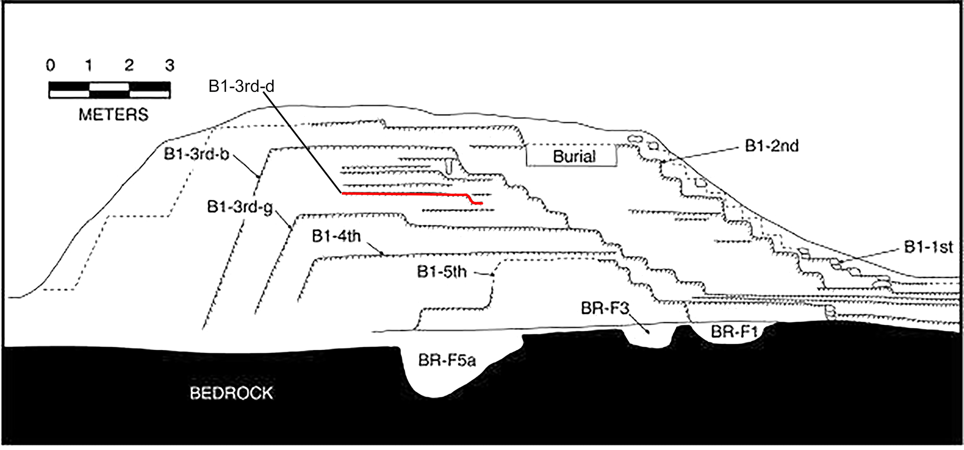
Figure 1. Profile of Structure B1 construction sequence (Brown and Garber Reference Brown and Garber2005:Figure 2).
Structures at Nakbe, such as Structure 49, rose to even greater heights, as much as 8 m above the original surface (Forsyth Reference Forsyth, Laporte, Escobedo and de Brady1993:117, 121). Like Blackman Eddy, the exteriors of the structures were built using large monolithic blocks, an apparent characteristic of late Middle Preclassic construction techniques. Likewise, in the Northern Lowlands, the acropolises at Xocnaceh (Gallareta Negrón Reference Gallareta Negrón, Kathryn Brown and Bey2018) and Poxila (Robles Castellanos and Ceballos Gallareta Reference Robles Castellanos, Gallareta, Brown and Bey2018) exhibit megalithic block construction, emphasizing a vertical monumentality during the late Middle Preclassic. According to Gallareta Negrón (Reference Gallareta Negrón, Kathryn Brown and Bey2018:285–286), the basal platform of Xocnaceh's acropolis was 64 m east–west by 24 m north–south (800/700–400/300 b.c.), although it rose to a height of just over 2 m. The next construction phase was a significant expansion, also dated to the late Middle Preclassic, with a basal platform of 140 × 140 m, a height of 6 m, and containing more than 100,000 m3 of fill. The Middle Preclassic acropolises at Xcoch (Smyth et al. Reference Smyth, Dunning, Weaver, Zapata and Rubenstein2017) and Yaxhom (Ringle et al. Reference Ringle, Negrón, Ciau, Seligson, Fernandez-Diaz and Zapata2021) may have been even larger, though their dimensions are masked in great part by later construction (Smyth et al. Reference Smyth, Dunning, Weaver, Zapata and Rubenstein2017). Therefore, we see that while monumentality emerged well before the transition to an agroeconomy was complete, the construction of public buildings accelerated and building types diversified and spread after 700 b.c.
EARLY INFRASTRUCTURE
In this section we will discuss the investment in agricultural and water management features that occurred during the Middle Preclassic. Agricultural features are difficult to identify in general and especially difficult to date, and those dated to the Middle Preclassic, through either ceramic identifications or radiocarbon dating, are particularly scarce. What we do know is primarily derived from excavations in the Southern Lowlands (Beach et al. Reference Beach, Luzzadder-Beach and Dunning2008; Dunning and Beach Reference Dunning, Beach, Martini and Chesworth2010; Dunning et al. Reference Dunning, Akpinar, Carr, Griffin, Jones, Lentz, Miller, Prater, Urquizú and Saturno2008; Hansen et al. Reference Hansen, Bozarth, Jacob, Wahl and Schreiner2002; Jacob Reference Jacob1995; Pohl et al. Reference Pohl, Bloom, Pope and Pohl1990, Reference Pohl, Pope, Jones, Jacob, Piperno, deFrance, Lentz, Gifford, Danforth and Josserand1996).
Ditching in wetlands began at places such as Cob Swamp as early as 1000 cal b.c., consistent with evidence from San Antonio on Albion Island (Pohl et al. Reference Pohl, Bloom, Pope and Pohl1990) and Colha (Jacob Reference Jacob1992, Reference Jacob1995). Initially, ditching appears to have been an adaptation designed to mitigate rising water tables and extend the growing period during the dry season, as ditches allowed fields on wetland margins to drain at a faster rate at the end of the rainy season (Beach et al. Reference Beach, Luzzadder-Beach, Dunning, Jones, Lohse, Guderjan, Bozarth, Millspaugh and Bhattacharya2009:1715; Pohl et al. Reference Pohl, Bloom, Pope and Pohl1990). Investigations in intermittent wetlands indicate that Maya agriculture was extensive during this period, and generally consisted of dry season farming along the margins of wetlands, and rainy season farming in uplands. Nevertheless, sediments, including clay, from slope erosion, likely linked to human activity in upland areas, aggraded over earlier paleosols during the latter part of this period (Beach et al. Reference Beach, Luzzadder-Beach and Dunning2008:312, Reference Beach, Luzzadder-Beach, Dunning, Jones, Lohse, Guderjan, Bozarth, Millspaugh and Bhattacharya2009:1716; Dunning et al. Reference Dunning, Hernández, Beach, Carr, Griffin, Jones, Lentz, Luzzadder-Beach, Reese-Taylor and Šprajc2019:136–140).
By the end of the Middle Preclassic (500–300 b.c.), farmers commenced the construction of terraces along bajo margins to adjust for erosion and sedimentation (Beach et al. Reference Beach, Luzzadder-Beach and Dunning2008:312, Reference Beach, Luzzadder-Beach, Dunning, Jones, Lohse, Guderjan, Bozarth, Millspaugh and Bhattacharya2009; Dunning and Beach Reference Dunning, Beach, Martini and Chesworth2010; Garrison and Dunning Reference Garrison and Dunning2009). Near the site of San Bartolo, a terrace system was constructed on the margins of the Bajo Donato to retard the severe soil erosion initiated by slope clearance prior to this time (Dunning et al. Reference Dunning, Akpinar, Carr, Griffin, Jones, Lentz, Miller, Prater, Urquizú and Saturno2008, Reference Dunning, Hernández, Beach, Carr, Griffin, Jones, Lentz, Luzzadder-Beach, Reese-Taylor and Šprajc2019; Garrison and Dunning Reference Garrison and Dunning2009:539). In addition, upland terraces, while uncommon during the Middle Preclassic, were not absent. At Chan, Belize, terrace construction north of the site core near a natural spring began in the Middle Preclassic and continued through the Late Classic (Wyatt Reference Wyatt2008). Together, the initiation of terracing and perhaps other forms of erosion mitigation clearly indicated that the Maya had become aware of the hazards associated with removing forest cover from sloping terrain and the amount of soil cover that was being lost. Maya farmers also likely became aware that terracing further had the benefit of adding to soil moisture levels that would have increased crop yields (Dunning and Beach Reference Dunning, Beach, Martini and Chesworth2010; Hansen et al. Reference Hansen, Bozarth, Jacob, Wahl and Schreiner2002).
Landesque capital involves the building of productive and sustainable landscapes, ensuring not only the viability of agriculture in a region, but also long-term occupation (Hoaen and Loney Reference Hoaen, Loney, Chadwick and Gibson2013). In the Maya Lowlands, reliable access to potable water, especially during the dry season, was crucial to the success of sedentary communities. Consequently, after 800 b.c., in addition to investing in agricultural features, Middle Preclassic people also collaborated to build reservoirs for water storage on a grand scale. There is no direct evidence that water storage systems were used explicitly for agricultural purposes. However, even if they did not contribute to increasing crop yields, the water stored would have been critical for sustaining sedentary populations during the dry season.
Example of early reservoirs are notable in the Southern Lowlands, especially in the Central Karstic Uplands. First detected by LiDAR in 2014, Brisa Reservoir is both the oldest and largest known reservoir at Yaxnohcah. Excavations in Brisa Reservoir at Yaxnohcah have revealed that it originated around 800–600 b.c. (Dunning et al. Reference Dunning, Hernández, Haggard, Carr, Hernández and Reese-Taylor2017, Reference Dunning, Brewer, Carr, Hernández, Beach, Chmilar, Sierra, Griffin, Lentz, Luzzadder-Beach, Reese-Taylor, Saturno, Scarborough, Smyth, Valdez, Larmon, Lucero and Valdez2022). The reservoir is enormous, with a surface area of almost 39,379 m2, but is rudimentary compared with later constructions (Figure 2). It was created by walling off a section of the Bajo Tomatal adjacent to an angled quarried limestone scarp. The berm that surrounded this early reservoir lies below the Brisa E-Group, which, based on ceramic identifications, was built earlier, between 1000 and 800 b.c.

Figure 2. Brisa Reservoir, berm, and catchment area, the oldest and largest known reservoir in Yaxnohcah, Campeche, Mexico. Map by Reese-Taylor and Montgomery.
The lower depth of the early Middle Preclassic bajo soil surface within the tank of Brisa Reservoir relative to its position under the berm indicates that the reservoir was constructed utilizing a pre-existing low spot along the edge of Bajo Tomatal that may have naturally accumulated water in the wet season. No floors were recovered in excavations, suggesting that the builders used the natural clay layers encountered 1 m below the current surface to prevent water seepage. The berm that defined the reservoir's southern and eastern sides appears to have been constructed initially between 800 and 650 b.c. but modified episodically to provide even greater elevation and width throughout the Middle and Late Preclassic periods. The berm height ranges from 238.3 m to 242.3 m.a.s.l. It has sloped walls, an average width of 40 m, and an overall perimeter length of approximately 390 m along the southern and eastern sides of the reservoir, which equates to a surface area of 15,605 m2.
The base of the berm was formed by a relatively thin layer of lighter-colored clay, overlain with a thick deposit of bajo topsoil likely dredged from the adjacent bajo surface. Subsequently, a deposit of soil, sascab, and gravel was used to further heighten the berm. Ceramics recovered in both the deposit of bajo soil and the overlying fill were identified as belonging to the late facet Macal complex (800–650 b.c.). Late Preclassic ceramics assigned to the Chay complex (400–200 b.c.) were recovered near the upper soil surface, likely deposited during a later dredging episode or during continued use of the reservoir.
We used the volume tool in ArcGIS Pro to estimate the capacity of the Brisa Reservoir. Based on the average height of the berm and the current topography of the sloping walls and reservoir floor, we calculated a capacity of approximately 89,379 m3. However, during its use, it was likely much larger, as excavations of the clay layers forming the floor were 1 m deeper than the current surface.
Brisa Reservoir takes its name from the Brisa E-Group complex situated atop the escarpment on the north side of the reservoir. Runoff from this group was channeled into Brisa Reservoir, indicating the close association of ritual activity conducted in the E-Group and emergent water management practices during the Middle Preclassic. The catchment zone for Brisa Reservoir also included a large area of unpaved surface, modified from the surrounding terrain, that formed a basin directing runoff into the reservoir at the base of the escarpment. The edges of the irregular basin likely followed a natural contour in the landscape and sloped steeply toward the interior of the basin. The base of the catchment basin was slightly sloped toward a single spillway, used to funnel water into the reservoir. The surface area of catchment basin and the spillway encompassed approximately 22,000 m2. Excavations in the center of the basin revealed a buried paleosol at a depth of around 80–120 cm below the surface, overlaying the sascab bedrock. Levels above the paleosol consisted of aggraded sediments eroded from the surrounding elevated areas. Ceramics recovered from the paleosol consist exclusively of early Middle Preclassic types (Macal complex). This suggests that the catchment basin, the spillway, and the Brisa Reservoir were constructed simultaneously during the early Middle Preclassic, just after the construction of the early Brisa E-Group complex. Together these features, including the Brisa E-Group complex, constituted a landscape modification for managing water that encompassed a minimum of 189,500 m2 (Figure 2).
In addition to the Brisa Reservoir, additional reservoirs located in the Central Karstic Uplands appear to be constructed using the same techniques (Morales-Aguilar and Hansen Reference Morales-Aguilar and Hansen2019). Several reservoirs share common elements, such as a location at the edge of a large bajo adjacent to a steep slope, a berm surrounding the inner tank, and a rectangular shape. These reservoirs include the El Mirador Reservoir, adjacent to the El Tigre triadic complex at El Mirador; the La Jarrilla Reservoir, located in an arm of the La Jarrilla bajo between El Mirador to the north and La Muerta to the south; the Nakbe Reservoir, situated south of the eastern complex at Nakbe; the Isla de Ramón Reservoir, and the Tintal Reservoir, located east of the Henequén complex. Like Brisa, each of these reservoirs has a large area on the adjacent elevated terrain that would have served as a catchment surface for runoff channeled into the storage feature. The La Jarrilla Reservoir also possessed several unique features. Although located immediately beneath a steep slope, the reservoir is elongated with a roughly north–south orientation with the El Mirador-Tintal causeway lying adjacent and parallel to the western berm.
According to Morales-Aguilar and Hansen (Reference Morales-Aguilar and Hansen2019), the Nakbe and the La Jarrilla reservoirs date to the Middle Preclassic. Ceramics recovered during excavations of the La Jarrilla berm suggest that it was constructed between 650 and 550 b.c., and a carbon sample obtained in a deep level within the berm yielded a date of 580 b.c., confirming the date of the ceramics. Like the Brisa Reservoir at Yaxnohcah, the La Jarrilla Reservoir was likely dredged and the berm elevated during the Late Preclassic (Morales-Aguilar and Hansen Reference Morales-Aguilar and Hansen2019).
Excavations in San Bartolo Aguada revealed that it began as a limestone quarry, which was converted to a central reservoir by lining the floor with a thick coat of plaster (Dunning et al. Reference Dunning, Akpinar, Carr, Griffin, Jones, Lentz, Miller, Prater, Urquizú and Saturno2008; Garrison and Dunning Reference Garrison and Dunning2009). This reflects a major investment in infrastructure that is not apparent in other Central Karstic Uplands reservoirs, though the San Bartolo Reservoir is notably smaller than those discussed above. Charcoal embedded in the plaster floor produced a radiocarbon date of 780–410 cal b.c. The Aguada Tintal, a smaller reservoir located 7 km north of the main precinct at San Bartolo, also dates from 780–410 b.c.
In the Northern Lowlands, infrastructure is not as apparent, but the agroeconomy seemed to be thriving, based on the number of large Middle Preclassic sites now known from the region. On the northern fringe of the Puuc Region, the large site of Xocnaceh is located along the foot of the Sierrita de Ticul, which provided access to productive cumulic soils eroded from the north face of the Puuc escarpment and permanent water from rock-hewn wells (Gallareta Negrón Reference Gallareta Negrón, Kathryn Brown and Bey2018:289). In the Puuc region proper, Preclassic sites were distributed adjacent to larger basins of higher quality soil and settlements were anchored by large reservoirs (Ringle et al. Reference Ringle, Negrón, Ciau, Seligson, Fernandez-Diaz and Zapata2021; Smyth et al. Reference Smyth, Dunning and Carr2020). At Xcoch, the earliest known floor in the largest reservoir, Aguada La Gondola, lies at a depth of 310 cm below the surface and consists of compact clay and sascab (Smyth et al. Reference Smyth, Dunning, Weaver, Zapata and Rubenstein2017). An AMS date of 89 b.c.–a.d. 1 was obtained from a carbon sample from the floor; however, it is possible that early Middle Preclassic floors lie beneath this level, as excavations were discontinued before reaching the natural surface underlying the reservoir. In addition, Aguada La Gondola is located at a terminus to a Middle Preclassic sacbe, which would have provided easy access to this important water source and connected it to a ritual complex at the mouth of the deep cave underlying the site center (Smyth et al. Reference Smyth, Dunning, Weaver, Zapata and Rubenstein2017). Aktun Xcoch cave contained a permanent water source that was regularly accessed during the early Middle Preclassic, based on the presence of Yotolin Patterned Burnished vessels found near the edge of the deep pool (Smyth et al. Reference Smyth, Dunning, Weaver, Zapata and Rubenstein2017).
DISCUSSION: THE ENTANGLEMENT OF LANDESQUE CAPITAL AND SOCIOPOLITICAL COMPLEXITY IN THE MIDDLE PRECLASSIC
From our assessment, patterns pertaining to the emergence of landesque capital during the Middle Preclassic reflect both the shift to an agricultural economy and the availability and organization of communal labor during the Middle Preclassic. Subsistence transitioned from broad-spectrum horticulture to an increased reliance on maize agriculture at about 1000 b.c. throughout the Lowlands. Interestingly, the inclusion of maize as a staple in diets preceded the emergence of farming by as much as 1,000 years. Isotopic evidence on human remains from southern Belize show that at least some individuals had a diet that consisted of 50 percent C4 plants or animals who ate C4 plants by 2000 b.c. (Kennett et al. Reference Kennett, Prufer, Culleton, George, Robinson, Trask, Buckley, Moes, Kate, Harper, O'Donnell, Ray, Hill, Alsgaard, Merriman, Meredith, Edgar, Awe and Gutierrez2020). The increase in maize as a dietary element coincided with evidence for burning throughout the Lowlands (1400–900 b.c.) and the appearance of the constricted adze (3000–1000 b.c.) as a general-purpose tool, all of which suggest that extensive gardening was practiced by small mobile groups.
Yet by all accounts, populations in the Maya Lowlands did not fully embrace sedentism for another 100–200 years, as evidence is amassing that mobile lifeways continued, at least in part, until 800 b.c. From 1000 to 800 b.c., during this interregnum between the emergence of maize agriculture and the complete shift to a sedentary lifeway, the lowland Maya constructed enormous platforms and leveled massive hilltops to create spaces for communal activities, including sweat baths (Estrada-Belli Reference Estrada-Belli2011; Hammond and Bauer Reference Hammond and Bauer2001; Inomata et al. Reference Inomata, Triadan, Aoyama, Castillo and Yonenobu2013, Reference Inomata, Triadan, Pinzón and Aoyama2019, Reference Inomata, Triadan, Vázquez López, Fernandez-Diaz, Omori, Méndez Bauer, Hernández, Beach, Cagnato, Aoyama and Nasu2020, Reference Inomata, Fernandez-Diaz, Triadan, Mollinedo, Pinzón, Hernández, Esquivel, Sharpe, Beach, Hodgins, Durón Díaz, Luna, Chávez, Hernández Jiménez and Moreno Díaz2021; Źralka et al. Reference Źrałka, Hermes, Velásquez, Koszkul and Wasilewski2022), and E-Groups were built in the western lowlands, the Central Karstic Uplands, and into central Peten (Aimers and Rice Reference Aimers and Rice2006; Doyle Reference Doyle2012; Estrada-Belli Reference Estrada-Belli2006, Reference Estrada-Belli2011; Hansen Reference Hansen and Houston1998; Inomata Reference Inomata, Triadan, Aoyama, Castillo and Yonenobu2013; Inomata et al. Reference Inomata, Triadan, Vázquez López, Fernandez-Diaz, Omori, Méndez Bauer, Hernández, Beach, Cagnato, Aoyama and Nasu2020; Pugh et al. Reference Pugh, Rice, Chan Nieto, Meranda and Milley2022; Reese-Taylor Reference Reese-Taylor, Freidel, Chase, Dowd and Murdock2017; Rice and Pugh Reference Rice and Pugh2017; Rice et al. Reference Rice, Pugh and Nieto2019).
Collective labor prior to 800 b.c. seems to have been directed toward projects promoting communal cohesion and community building. These projects created public places for ritual practices centered around the life-cycle of maize (Estrada-Belli Reference Estrada-Belli2006, Reference Estrada-Belli2011; Taube Reference Taube2005), which the early Maya deemed crucial for the success of growing communities and their incipient agricultural systems. This is most evident in the jade celt caches dating to 1000–800 b.c., recovered from early E-Groups at Ceibal and Aguada Fénix (Inomata Reference Inomata, Freidel, Chase, Dowd and Murdock2017; Inomata and Triadan Reference Inomata and Triadan2016; Inomata et al. Reference Inomata, Triadan, Vázquez López, Fernandez-Diaz, Omori, Méndez Bauer, Hernández, Beach, Cagnato, Aoyama and Nasu2020).
In addition, innovations in cultivation and building practices led to changes in manufacturing skills, specifically in lithic production. Most notably, the constricted adze, the Preceramic gardening tool of choice, was replaced during the early Middle Preclassic by the oval biface. This general utility tool not only supplanted the constricted adze for wood cutting, chopping, and other horticultural activities, but was also useful for moving soil and preparing bedrock, a necessary prelude to creating fields for agriculture and building structures, quarrying limestone for construction materials, and shaping limestone blocks.
While the timing of the first permanent settlements varied from region to region, by 800 b.c., sedentism appeared to be an established lifeway throughout the Maya Lowlands. Evidence for permanent communities has been recovered in the Belize River Valley (Awe Reference Awe1992; Ebert et al. Reference Ebert, May, Culleton, Awe and Kennett2017; Powis et al. Reference Powis, Healy and Hohmann2009), northern Belize (Hammond Reference Hammond1991; Hester et al. Reference Hester, Shafer and Eaton1982; McAnany and López Varela Reference McAnany and López Varela1999; Potter et al. Reference Potter, Hester, Black and Valdez1984; Valdez Reference Valdez1987), the Pasion River area (Adams Reference Adams1971; Triadan et al. Reference Triadan, Castillo, Inomata, Palomo, Méndez, Cortave, MacLellan, Burham and Ponciano2017), the Peten Lakes region (Pugh et al. Reference Pugh, Rice, Chan Nieto, Meranda and Milley2022; Rice and Pugh Reference Rice and Pugh2017; Rice et al. Reference Rice, Pugh and Nieto2019), the Central Karstic Uplands (Hansen Reference Hansen and Houston1998; Reese-Taylor et al. Reference Reese-Taylor, Dunning, Atasta Flores Esquivel, Hernández and Walker2018), the Gulf coast of Campeche (Ek Reference Ek2022), as well as in the Puuc Hills (Gallareta Negrón Reference Gallareta Negrón, Kathryn Brown and Bey2018; Parker et al. Reference Parker, Bey, Gu, Ward and Negrón2022; Smyth et al. Reference Smyth, Dunning and Carr2020).
After 800 b.c., not only did sedentary settlements become dominant in the landscape of the Maya Lowlands, but the construction of civic architecture accelerated. E-Groups continued in importance in the Central and Southern Lowlands and, after 700 b.c., spread to the Northern Lowlands, northern Belize, and the Belize River Valley. Between 800 and 700 b.c., water jars were included, along with jade, in E-Group caches at Ceibal and Cival (Estrada-Belli Reference Estrada-Belli2006, Reference Estrada-Belli2011; Inomata Reference Inomata, Freidel, Chase, Dowd and Murdock2017; Inomata and Triadan Reference Inomata and Triadan2016), suggesting a re-focus of ceremonial practices on water rites to ensure the timely commencement of the rainy season, crucial for the viability of humans and plants alike. Ballcourts were also present in the Northern Lowlands during the Middle Preclassic, perhaps as early as 700 b.c. (Robles Castellanos and Ceballos Gallareta Reference Robles Castellanos, Gallareta, Brown and Bey2018) and appear in the Southern and Central Lowlands by ca. 400–300 b.c. (Vázquez López et al. Reference Vázquez López, Reese-Taylor and Flores Esquivel2022).
The transition to agriculture, while allowing greater productivity, also resulted in new problems, such as soil erosion and the depletion of nutrients in soils. In addition, the effects of rising water tables on perennial wetland fields in coastal and riparian areas also diminished soil productivity, and strategies for addressing such changes were critical for the nascent agroeconomy (Beach et al. Reference Beach, Luzzadder-Beach, Krause, Guderjan, Valdez, Fernandez-Diaz, Eshleman and Doyle2019). Increased investment in infrastructure as a form of landesque capital followed the shift to more sedentary lifeways. This implies that in the Lowlands, long-term improvements were made as inhabitants became more capable of holding or controlling the investment (Blaikie and Brookfield Reference Blaikie and Brookfield1987; Brookfield Reference Brookfield, Billinge, Gregory and Martin1984). Ditching along the margins of perennial wetlands began as early as 1000 b.c. and is best documented in the Eastern Maya Lowlands at Cob Swamp, Albion Island, and similar locations. Creating ditches to speed up the draining of fields on wetland margins was a simple but effective solution to slowly rising water tables that augmented the number of days available for dry-season farming in wetland environments. Terraces, which retard soil erosion in upland areas for more productive farming during the rainy season, are uncommon in the archaeological record of this period. However, evidence from Chan, in western Belize, suggests that terraces were an important innovation in the late Middle Preclassic adjacent to this riverine floodplain area, and one which may be overlooked in many regions.
However, the most dramatic form of landesque capital seen in the Maya Lowlands during the Middle Preclassic is the reservoirs and catchment basins constructed by the inhabitants of the Central Karstic Uplands and other parts of the Elevated Interior Region, such as the Puuc, where perennial water sources were extremely scarce (Dunning et al. Reference Dunning, Beach and Luzzadder-Beach2012, Reference Dunning, Brewer, Carr, Hernández, Beach, Chmilar, Sierra, Griffin, Lentz, Luzzadder-Beach, Reese-Taylor, Saturno, Scarborough, Smyth, Valdez, Larmon, Lucero and Valdez2022). The reservoirs and catchment areas would have provided secure sources of water in the dry season, as well as mitigated runoff away from vulnerable bajo margin fields during the rainy season. Many central reservoirs are massive in size, with capacity estimates conservatively ranging in size from 69,300 m3 in some instances to 6,653 m3. Based on excavations in the Brisa Reservoir at Yaxnohcah, we understand that the construction was simple (Dunning et al. Reference Dunning, Brewer, Carr, Hernández, Beach, Chmilar, Sierra, Griffin, Lentz, Luzzadder-Beach, Reese-Taylor, Saturno, Scarborough, Smyth, Valdez, Larmon, Lucero and Valdez2022). Berms were built by drawing and piling bajo sediments in perimeters around previously existing low-lying areas. Known reservoirs had no formal floor during the Middle Preclassic, but instead depended on the natural, compacted clayey sediments of the bajos to hold water. Located adjacent to natural escarpments, each reservoir was positioned to take advantage of areas where natural runoff occurred. Catchment areas were amplified by skillful modifications. Builders enhanced the sloped natural (and, later, the constructed) landscape above the reservoirs by creating basins, which received the water and redirected it into the reservoir.
The Brisa berm was a massive earthwork, comprising over 66,4000 m3 of sediment and clay fill. In addition, this volume of fill does not include the amount of fill excavated from the basin of the reservoir to create a flattened and impermeable surface. At present, the interior of the reservoir is approximately 2 m below the exterior surface of the Bajo Tomatal. Assuming that sedimentation rates are the same for the interior and exterior of the reservoir, we can use this difference to calculate that a total of 80,266 m3 of sediment may have been removed from the interior and used to construct the berm. This one construction, then, represented a huge investment for Middle Preclassic Yaxnohcah. And of the six contemporaneous reservoirs of this type identified in the Central Karstic Uplands, only the La Jarrilla Reservoir at El Mirador was smaller.
Our understanding of landesque capital during the Middle Preclassic lags behind our knowledge of architectural constructions. However, from this brief overview, it is clear that landesque capital played a crucial role in the development of complexity in the Maya Lowlands. It is likely not coincidental that the most impressive examples of landesque capital in the Lowlands, the massive reservoirs of the Central Karstic Uplands, are found in a region that is known for its huge populations and large cities during the Late Preclassic. At Yaxnohcah, there appears to be a direct spatial relationship between the Brisa Reservoir and the most prominent Middle Preclassic architectural complex in the civic precinct, suggesting a degree of control by an emerging elite. This may also be the case at Nakbe, El Mirador, and El Tintal. Certainly, a large labor force, and possibly new lithic tool forms, were needed to construct and maintain the reservoir, which would have demanded collective action and cooperation among semi-autonomous communities in the Yaxnohcah area (Reese-Taylor Reference Reese-Taylor, Freidel, Chase, Dowd and Murdock2017; Vázquez López et al. Reference Vázquez López, Reese-Taylor and Flores Esquivel2022).
Indeed, the creation of many early reservoirs was interwoven with the expansion of communal architecture to a point that they cannot be considered independently. The Prehispanic Maya considered ideological practices to be crucial to the ongoing viability of human populations and agricultural systems alike and, at times, purposefully linked the places in which these rituals took place with large-scale infrastructure projects that also sustained life, enhancing the functionality of these features. In such cases, we argue that the boundaries between civic-ceremonial architecture and infrastructure were blurred, so much so that ceremonial precincts that directly affected the outcomes of sustainable practices and features should also be considered as landesque capital.
In the Central Karstic Uplands especially, the construction of reservoirs and enlargement of plazas and platforms appear to have been symbiotic endeavors, each influencing the final form of the other to such an extent that they must have been conceived and planned as a unit. In many cases, it is possible that the enlargement of early plazas may have had less to do with the need to accommodate more people than the need to direct and capture more water. Moreover, the ability of nascent elites to effectively envision and carry out ideologically complex construction projects with direct environmental and religious impacts ensured the lasting success and cohesion of the community and, no doubt, advanced the development of sociopolitical complexity during the Middle Preclassic.
The reservoirs and agricultural investments would also have contributed to the expansion of wetland agriculture in this region, which likely provided an advantage to the local inhabitants. Agricultural surpluses would have supported economic development, specifically the establishment of trade networks and craft specializations. Although trade networks and household specialization can be seen in all regions during the Middle Preclassic (Parker et al. Reference Parker, Bey, Gu, Ward and Negrón2022), the large-scale landesque capital in the Central Karstic Uplands may have been crucial for its economic success in the Late Preclassic.
Significantly, however, various forms of landesque capital were not limited to one region during the Middle Preclassic, but appeared throughout the Maya Lowlands and included not only infrastructure projects, such as reservoirs, but also civic complexes supporting ideological practices, which were viewed by the Maya as equally indispensable to the well-being of the community. While features of landesque capital appeared among the Maya as early as 1000 b.c., if not earlier, forms diversified and became entangled throughout the Middle Preclassic. As a result, an ontology of landesque capital arose, based on the synergistic fusing of daily and ritual practices with physical features, which established a foundation for resilience, sustainability, and well-being in subsequent generations.
RESUMEN
En las tierras bajas mayas, el preclásico medio (1000–300/400 a.C.) se caracteriza por cambios a gran escala vinculados con el establecimiento de las primeras comunidades sedentarias y la vida cívica. Hacia finales de este período se observa el surgimiento de los primeros estados y la centralización de la autoridad expresada mediante la figura del gobernante. En este trabajo nos centramos en la relación entre el capital paisajístico y la complejidad sociopolítica en las tierras bajas mayas, con el fin de obtener un mejor entendimiento de la naturaleza de las transformaciones ocurridas durante el preclásico medio. Capital paisajístico (landesque capital) se refiere a la inversión permanente en la modificación de la tierra que resulta en mayores rendimientos agrícolas y el abastecimiento confiable de agua —reservorios, áreas de captación de agua, sistemas de irrigación y suelos antropogénicos, entre otros. Este tipo de capital consiste en la construcción de paisajes productivos y sustentables que aseguran la viabilidad de la agricultura y la ocupación a largo plazo en un entorno (Hoaen y Loney Reference Hoaen, Loney, Chadwick and Gibson2013), por lo que implica la interacción entre humanos y ecosistemas. Consideramos que esta infraestructura económica también incluyó a los complejos cívico-ceremoniales porque estos no sólo dirigieron el flujo de agua a los reservorios, sino que también constituyeron el escenario de prácticas rituales que aseguraba la buena voluntad de los dioses en las prácticas agrícolas. De esta manera, estas inversiones permanentes en el paisaje aumentaron la resiliencia, la sustentabilidad y el bienestar entre los mayas tempranos.
En el presente trabajo argumentamos que estos desarrollos fueron la consecuencia de la modificación continua y acumulada del suelo que tomó lugar en el período precerámico/preclásico temprano, y la inversión de mano de obra en rasgos agrícolas, grandes obras públicas y determinados complejos cívicos durante el preclásico medio. Llama la atención que el momento y la ubicación de las inversiones de este período estén fuertemente correlacionados con procesos fundamentales como la transición al sedentarismo, el control de los recursos, cambios en la producción lítica y una élite emergente. Observamos que durante el preclásico medio, algunas de las mayores inversiones de este tipo de ambiente construido ocurrieron en la meseta kárstica central, culminando en el surgimiento de grandes ciudades en el preclásico tardío.
ACKNOWLEDGEMENTS
This research was funded by the Social Sciences and Humanities Research Council of Canada, Grants 430-2017-00190 and 892-2019-3070, the National Science Foundation, Grant BCS-163292, with ongoing financial support from the University of Calgary, the Universidad Autónoma de Campeche, and the University of Cincinnati. We also thank Jerry Murdock and Venture Capital Partners for their significant contributions to the LiDAR reconnaissance. The second author also thanks the Consejo Nacional de Ciencia y Tecnología (CONACyT) and its program of postdoctoral fellowships, “2do Año de Continuidad de Estancias Posdoctorales en el Extranjero Vinculadas a la Consolidación de Grupos de Investigación y Fortalecimiento del Posgrado Nacional,” Convocatoria 2019 (1).
We also extend our thanks to the Instituto Nacional de Antropología e Historia (INAH), Campeche, and Comisíon Nacional de Áreas Naturales Protegidas (CONANP), especially Adriana Velázquez Morlet, Director of the Centro INAH Campeche, and José Adalberto Zuñiga Morales, Director of the Calakmul Biosphere Reserve-CONANP, for their continued support of our research in the Calakmul biosphere. In addition, we express our appreciation to Drs. Juan Carlos Fernández-Díaz and Ramesh Shrestha for their assistance in the LiDAR collection and classification. We would also like to thank Drs. Carlos Morales-Aguilar and Christopher Carr for illuminating conversations regarding the calculation of reservoir capacities and berm volumes. We are grateful to Drs. M. Kathryn Brown, Julia Guernsey, Felix Kupprat, and Michael Love for thought-provoking discussions regarding landesque capital in eastern Mesoamerica. We also want to acknowledge Dr. Nancy Gonlin for her support and guidance during this process. Finally, we thank all members of the Yaxnohcah Archaeological Project and the ejidos of Conhuas, Concepción, Constitución, and Pablo García, Campeche.


 Open access