


On the southern coast of Peru during the Middle Horizon, the Tiwanaku civilization expanded into the Osmore-Moquegua basin. Its political epicenter was at the southern part of the Lake Titicaca basin, where remains of the colossal precolumbian urban complexes of Tiwanaku and Lukurmata are still visible (Figure 1). Dense Tiwanaku settlements within the Moquegua region were established mainly in the middle section of the Osmore-Moquegua River valley, with some in the southern part of its upper section (Owen Reference Owen2005:Figure 11; Owen and Goldstein Reference Owen and Goldstein2001:180). Such settlements, however, were not found in the lower section of the river valley and the adjacent Pacific coast (Moseley Reference Moseley2001:242; Owen Reference Owen2005:73; Stanish Reference Stanish, Isbell and Silverman2002:182–183). The presence of newcomers from the Altiplano in the Osmore-Moquegua basin is evidenced by materials in Omo and Chen Chen ceramic styles, associated with other elements of material culture, settlement patterns, and burial forms (Owen and Goldstein Reference Owen and Goldstein2001:171). These document various stages of the migration waves of different ethnic groups or moieties of Tiwanaku (Goldstein Reference Goldstein1993, Reference Goldstein2005; Owen and Goldstein Reference Owen and Goldstein2001), in what Owen describes as the first-stage diaspora (Reference Owen2005:63–65). Materials in the Omo style are related to the earlier migration, beginning at around AD 700, whereas the Chen Chen style became evident in the valley around AD 850, coexisting with the earlier style until the collapse of the Tiwanaku state (Goldstein Reference Goldstein2005; Owen and Goldstein Reference Owen and Goldstein2001:171, 174). A genetic connection between the populations represented by the Omo and Chen Chen styles with the inhabitants of the Tiwanaku mainland has been confirmed by a non-metric analysis of osteological material from cemeteries and by isotope analysis (Knudson et al. Reference Knudson, Douglas Price, Buikstra and Blom2004; Sharratt Reference Sharratt2019).

Figure 1. The southern Andes. Map showing the location of the archaeological sites mentioned in the text (map graphics by Nickole Lenkow).
Within the Osmore-Moquegua basin, the period of the collapse of the Tiwanaku state in the Lake Titicaca basin (ca. AD 1000) is usually referred to as the terminal Tiwanaku or the terminal Middle Horizon (Goldstein Reference Goldstein, Rice, Stanish and Scarr1989; Sharratt and Williams Reference Sharratt and Williams2008). It is associated with materials in the Tumilaca style and the elements that accompany them. It is generally accepted that the terminal Middle Horizon lasted until the thirteenth century AD (Owen Reference Owen2005; Sims Reference Sims, Schwartz and Nichols2006), although recent research suggests instead that it lasted until the mid-fourteenth century (Sharratt Reference Sharratt2019:530).
Existing social, religious, and economic orders underwent great change at that time. These transformations are visible in the settlement model, which is characterized by translocations and growing urbanization. These processes began before the fall of Tiwanaku and thus were the cause of political breakdown in the valley, and not their result (Owen Reference Owen2005); Owen refers to these changes as the “second-stage diaspora” (Reference Owen2005:65–73), which is associated with the establishment of Tumilaca settlements in the Osmore-Moquegua basin. Large, unfortified urban settlements in the Tiwanaku state were abandoned at that time, along with religious and economical infrastructure (Goldstein Reference Goldstein2005; Owen Reference Owen2005; Williams Reference Williams2002). They were replaced by relatively small, occasionally fortified or naturally defensible settlement points of regional importance (Owen Reference Owen2005; Owen and Goldstein Reference Owen and Goldstein2001); these terminal Tiwanaku settlements did not feature any defensive structures (Owen Reference Owen2005, Reference Owen2009; Sharratt Reference Sharratt2011). The only exception was the settlement area without any defensive structures near the lower part of the river and the Pacific coast, where materials known as Ilo-Tumilaca/Cabuza can be found (Owen Reference Owen1993, Reference Owen2005, Reference Owen2009; Sharratt Reference Sharratt2011).
Yet, evidence of cultural continuity from before the fall of the Tiwanaku state can be observed in Tumilaca and Ilo-Tumilaca/Cabuza contexts (Owen Reference Owen2005). A biological link between the communities living during the state's existence and after its fall is confirmed by non-metric dental features analysis (Sharratt Reference Sharratt2019; Sutter and Sharratt Reference Sutter and Sharratt2010). Cultural continuity is visible in artifacts, especially pottery, that feature a continuation of forms, colors, and iconography from the state period and that are often difficult to differentiate from the Chen Chen specimens from which they derived (Bermann et al. Reference Bermann, Goldstein, Stanish, Watanabe, Rice, Stanish and Scarr1989; Goldstein Reference Goldstein, Rice, Stanish and Scarr1989, Reference Goldstein1990; Owen Reference Owen2005). One noticeable change is the disappearance of images of the Staff God, a major deity associated with Tiwanaku state ideology (Bermann et al. Reference Bermann, Goldstein, Stanish, Watanabe, Rice, Stanish and Scarr1989; Goldstein Reference Goldstein1993:42, Reference Goldstein2005). A visual analysis of Tumilaca pottery found ornaments of lower quality and with more geometric motifs than on items from the Tiwanaku state period (Williams et al. Reference Williams, Moseley, Lozada and Sharratt2006). There were also a noticeably larger variety of forms and their variants of Tumilaca pottery, notably the appearance of “oversized” vessels, such as the keros from the Tumilaca la Chimba cemetery (Sharratt Reference Sharratt2011:97). In residential architecture, at least in the central part of the valley, already existing urban forms/concepts were continued, using the same construction technology (Bawden Reference Bawden1990; Goldstein Reference Goldstein2005; Owen Reference Owen2005). The cemeteries feature the continuation of previously used burial forms (Goldstein Reference Goldstein, Rice, Stanish and Scarr1989, Reference Goldstein1993; Goldstein and Owen Reference Goldstein and Owen2001; Owen Reference Owen2001; Sharratt Reference Sharratt2011). However, some forms characterizing the state period, particularly those in Omo and Chen Chen styles, disappeared (Bermann et al. Reference Bermann, Goldstein, Stanish, Watanabe, Rice, Stanish and Scarr1989; Green et al. Reference Green, Baitzel, Muñoz, Palacios and Goldstein2007; Isbell and Korpisaari Reference Isbell and Korpisaari2012:106–107; Sharratt Reference Sharratt2019:532).
The migrations during the second-stage diaspora occurred on both regional—within the area of Tiwanaku settlement itself in the Osmore-Moquegua Valley—and interregional scales. The result was an influx of newcomers (refugees) from the Altiplano and the movement of people representing the Tiwanaku tradition into previously unexplored regions of the Osmore Valley and beyond (Owen Reference Owen2005:46, 65–66; Reference Owen2009:437–442). In the period right before and after AD 1000, these people migrated into the shoreline part of the valley and into the upper part of the Osmore-Moquegua basin (Owen Reference Owen2005:65, Reference Owen2009:437). They also moved to Caruma-Calacoas region, which belongs to the Tambo basin (Owen Reference Owen2005:66, Reference Owen2009:437–438). Their presence is suggested as far south as the Locumba, Sama, and Capilina Valleys (Owen Reference Owen2009:Figure 3), as well as in the Azapa Valley (Cassman Reference Cassman1997; Korpisaari et al. Reference Korpisaari, Oinonen and Chacama2014) where aggregations of Tiwanaku elite were living as early as the Middle Horizon (Berenguer and Dauelsberg Reference Berenguer, Dauelsberg, Hidalgo, Schiappacasse, Niemeyer, Aldunate and Solimano1989; Goldstein Reference Goldstein1995:64; Knudson et al. Reference Knudson, Douglas Price, Buikstra and Blom2004; Owen Reference Owen2005:52).
For the area to the north of the Osmore-Moquegua basin, population movements are suggested by the presence of Tiwanaku-related materials in the Arequipa region (Owen Reference Owen2005:66, Reference Owen2009:449–452; Owen and Goldstein Reference Owen and Goldstein2001:182). First proposed by Max Uhle at the beginning of the twentieth century, (López Reference López2001:62), this northward migration was supported by the later findings of Luis G. Lumbreras (Reference Lumbreras1974:71–73). He split the Churajón-style finds into two stylistic-chronological groups. The first one (older) is characteristic of finds from the Cacallinca (Casa-Patak) site and shows similarities to the Mollo style from the Bolivian province of Muñecas; it is also more “Tiwanaku” in character than the second group, represented by Churajón finds from the Challapampa site (Lumbreras Reference Lumbreras1974:71). It should be noted that Lumbreras does not postulate any direct expansion of Tiwanaku people into Arequipa, save perhaps for representatives of states/kingdoms that were founded on its remains. Lumbreras's classifications were modified by Marco López (Reference López2001), who defined a separate, earlier Casapatak phase in the early Churajón materials assembled by Lumbreras, which is similar to Tiwanaku and Cacallinca styles and encompasses the remaining early Churajón material. Augusto Cardona (Reference Cardona2002:75–106) distinguished a group of sites in the Arequipa region with Casapatak materials, which he associated with the Middle Horizon, assuming the existence of an analogous situation to that in the Chen Chen settlement in Moquegua. In contrast, Bruce Owen (Reference Owen2009:450) claimed that the ceramic finds were associated with groups of refugees searching for new places to live after the fall of Tiwanaku. Such population movements resulted in the following styles: Mollo from Muñecas in Bolivia, Tumilaca from the upper and lower Osmore-Moquegua basin, and pottery from Caruma-Calacoa.
The presence of Tumilaca-style vessels and pottery fragments within the Arequipa agglomeration cannot be denied (Cardona Reference Cardona2002; López Reference López2001), yet there is no basis for dating their origins to the period of Tiwanaku state. Example of such finds are a sherd from the Sonquonata site (Cardona Reference Cardona2002:86) and fragments of a censer (incensario) and other vessels from the unpublished, devastated multicultural site Quillocona 1 near Chiguata. Tiwanaku pottery fragments were also noted at Cujanillo in the Siguas Valley (Yépez Álvarez et al. Reference Yépez Álvarez, Jennings and Berquist2018:Figure 1). Individual examples of pottery—labeled as from the Arequipa region—are also kept in various museum collections within the city of Arequipa. This small amount of diagnostic material and lack of documented contexts cannot be used as an argument for Tiwanaku settlement in this region, proving only the existence of some interregional contacts. Other materials should be classified instead as early Churajón phase I (post-Tiwanaku), which developed until the Late Horizon (Szykulski Reference Szykulski2010:263–265). These materials correspond—as do Mollo artifacts—in color and form with Tiwanaku pottery but are only its imitation. It should be highlighted that, among thousands of ceramic Churajón artifacts from multiple sites (Casa Patak, Colegio Independencia Americana, César Vallejo, Sachaca Fernandini, Campus de la Universidad, Tres Cruzes, and Churajón comples) and now housed at the Museo Arqueológico de la Universidad Católica de Santa María-Arequipa and Museo Arqueológico de la Universidad Nacional de San Agustín de Arequipa (Szykulski Reference Szykulski2010; Szykulski and Belan Reference Szykulski and Franco1998), not a single example featuring figural Tiwanaku iconography has been noted. Undoubtedly this lack of figural iconography stands in stark contrast to Tumilaca pottery from Moquegua, belonging to the Altiplano civilization and often difficult to differentiate from the Chen Chen style from Moquegua. Furthermore, the only common element in early Churajón and Mollo pottery is the earlier mentioned tricolored geometric ornamentation (Szykulski Reference Szykulski2010:Figures 107 and 118), found among other pottery in southern Peru as well. The forms of Churajón and Mollo vessels significantly differ from each other (Szykulski Reference Szykulski2010:Figures 103–104 and 115–116). We can then assume the existence of a connection between early Churajón and Bolivian Mollo pottery and the Tiwanaku tradition, but surely there is no direct link like Tumilaca. It is more probable that the colors and patterns of Churajón were borrowed from post-collapse Tiwanaku-Tumilaca communities. We therefore believe that there is little chance that the second-stage Tiwanaku diaspora reached the region of Arequipa.
Our research focuses on the area located north of Osmore-Moquegua in the lower part of the Tambo Valley, where a large community representing the Tiwanaku tradition moved (Szykulski et al. Reference Szykulski, Bewziuk and Wanot2015, Reference Szykulski, Lewis, Wanot, Mikocik, Krajewska and Bewziuk2016). An international archaeological expedition exploring the left-sided edge of Tambo delta (Figure 1) discovered the La Pampilla 1 cemetery, along with funerary contexts containing Tumilaca pottery (Figure 2).

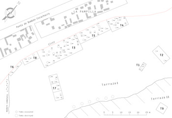
Figure 2. Plan of La Pampilla 1 archaeological site showing the excavations’ boundaries (T1–T9) and the exact location of the graves (H1–H81) (graphic by Nickole Lenkow).
Tiwanaku in the Tambo Valley
The lower section of the Tambo Valley is located within the administrative boundaries of the Cocachacra District and Islay Province, parts of the Arequipa Department. Its beginning is marked by a point which is located more or less on the border of the Arequipa and Moquegua Departments where the steep, rocky gorge of the Tambo Valley begins to expand (Szykulski et al. Reference Szykulski, Lewis, Wanot, Mikocik, Krajewska and Bewziuk2016:21–23). The valley in this area forms a vast river oasis with wide and fertile terraces located on both sides of the river, which have been used for agricultural purposes since precolombian times. The hydrology of the area mainly depends on the amount of water supplied by the upper section of the Tambo fluvial system, which is located in the high mountain region of the Andes. Thus, this area has both a rainy and a dry season. An additional source of moisture in the coastal zone is the periodically occurring garúa—thick fog or drizzle—that appears with varying intensity from May to November.
Cultural Sequence in Lower Tambo
Current research results show that. before the appearance of Tumilaca communities, the lower Tambo basin was inhabited by agricultural-pottery societies represented by the Islay pottery style (Neira Avendaño Reference Neira Avendaño, Avendaño, Rodríguez, Málaga, Soldan and Carpio1990:93–94; Szykulski Reference Szykulski2017). Islay contexts come from the El Pino 7 cemetery, located on the left bank of the Tambo delta, where multiple intact burials were discovered (Szykulski Reference Szykulski2017; Szykulski et al. Reference Szykulski, Lewis, Wanot, Mikocik, Krajewska and Bewziuk2016:78–83). Such materials have also been registered at the Pampa Blanca site (Krajewska and Mikocik Reference Krajewska and Mikocik2014:145, 156) and within the settlement terraces in the Quilca Valley (Szykulski Reference Szykulski2017:299–300). In addition to pottery, Islay burial contexts contain copper artifacts, stone tools, and shell and gemstone necklaces. Bows, arrows, and maces were also found (Szykulski Reference Szykulski2017:291–295), and heads of buried individuals were wrapped in a kind of turban (Szykulski Reference Szykulski2017:288), similar to those from Faldas de Morro and Alto Ramirez in the Arica region (Muñoz Reference Muñoz2019). In contrast to Alto Ramirez from Arica and Huaracane from Moquegua, no burial mounds were found (Feldman Reference Feldman, Rice, Stanish and Scarr1989; Goldstein and Owen Reference Goldstein and Owen2001:144–145; Muñoz Reference Muñoz1987:93). Within the El Pino 7 site a few fragments of Late Nazca pottery were also found (Szykulski Reference Szykulski2017:288; Wanot Reference Wanot2016:190–191), which may suggest some form of exchange with those distant areas. It should be noted that 103 burial contexts from El Pino 7 were preserved in situ and contained no intrusive materials belonging to Islay (Szykulski Reference Szykulski2017).
The analysis of archaeological contexts shows that Islay belongs to the long-developed tradition of the southern coast of Peru and northern Chile, including Faldas de Morro from Arica (Rivera Reference Rivera1975), Huaracane and Algodonal from Osmore-Moquegua (Goldstein and Owen Reference Goldstein and Owen2001), and La Ramada (Santos Ramírez Reference Santos Ramírez1980) and Siguas 3 (Haeberli Reference Haeberli2001) from the Siguas Valley. Acquired 14C dating is relatively late, indicating the period to be between the third and ninth century AD for the Islay culture (Early Intermediate Period [EIP]—Middle Horizon), which can be narrowed down to the fifth to eighth century AD (Szykulski Reference Szykulski2017:297–299). This dating frames the end of early type agricultural-pottery communities in this part of Peru.
Before research was conducted in La Pampilla 1, the presence of Tiwanaku in the lower Tambo basin was documented by sparse material of uncertain origin, as well as individual finds. Those included vessels from the cemetery in Arenal, located on the right-hand edge of the Tambo delta and devastated in the 1980s (Figures 1 and 3). A few sherds were also registered at the graveyards of Pampa Blanca and La Pampilla 2 (Krajewska and Mikocik Reference Krajewska and Mikocik2014:145, 155), and fragments of an anthropomorphic Tiwanaku keros (Figure 3) were found at Carrizal 1 in Yalaque Valley, belonging to the right-sided Tambo basin (Figure 1).
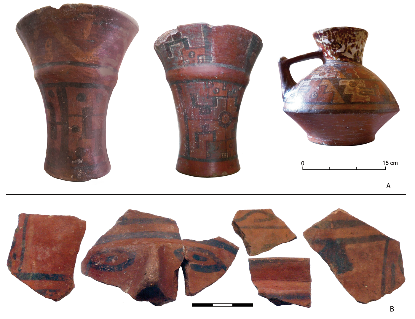
Figure 3. Tiwanaku materials probably registered within the El Arenal site near La Curva (A)—Museo Arqueológico de la Universidad Nacional de San Agustín de Arequipa, Río Tambo basin. Tiwanaku ceramic wares from the Carrizal 1 site (B) located in Yalaque Valley (photos by Jakub Wanot). (Color online)
The Late Intermediate Period (LIP) in the development sequence of the lower Tambo basin is determined by materials in the Chiribaya style, associated with a community whose epicenter was located within the mouth of the Osmore-Moquegua Valley (Bawden Reference Bawden1990; Ghersi Barrera Reference Gherssi Barrera1995; Kołomański Reference Kołomański2018; Lozada and Buikstra Reference Lozada and Buikstra2002). The presence of Chiribaya in the Osmore-Moquegua estuary is confirmed for the period preceding the presence of Tumilaca there as well. There are, however, large discrepancies regarding the initial date (cf. Goldstein Reference Goldstein2005; Lozada and Buikstra Reference Lozada and Buikstra2002; Owen Reference Owen2005). In Tambo we mainly dealt with cemeteries. Their concentration was noted on the right bank of the Tambo delta, where numerous Chiribaya burial sites were found, some of which contained Churajón, San Miguel, and Estuquiña pottery intrusions (Kołomański Reference Kołomański2018; Krajewska and Mikocik Reference Krajewska and Mikocik2014:Figure 15; Szykulski et al. Reference Szykulski, Lewis, Wanot, Mikocik, Krajewska and Bewziuk2016). Cemeteries and settlement relics are also present in El Toro, where the Huayrondo flows into the Tambo River (Figure 1; Mikocik Reference Mikocik2016; Szykulski et al. Reference Szykulski, Lewis, Wanot, Mikocik, Krajewska and Bewziuk2016:Figure 46). Chiribaya contexts discovered in the Tambo Valley are not very different from those in Moquegua in terms of forms of burials, pottery, and accompanying elements (Kołomański Reference Kołomański2018:118, 162; Mikocik Reference Mikocik2016:305). Two calibrated 14C dates for Chiribaya contexts from Tambo point to the fourteenth century AD (Kołomański Reference Kołomański2016:243, Reference Kołomański2018:54). In the lower Tambo basin only a minimal number of materials related to the expansion of Tawantinsuyu have been recorded (Mikocik Reference Mikocik2016; Szykulski et al. Reference Szykulski, Lewis, Wanot, Mikocik, Krajewska and Bewziuk2016:89). Therefore, the development sequence of the lower fragment of Tambo Valley so far includes (1) Islay style and fragments of Late Nazca pottery (EIP, Middle Horizon), (2) Tiwanaku materials (Middle Horizon?, beginning of LIP), (3) Chiribaya and intrusive Churajón, San Miguel, and Estuquiña wares (LIP, Late Horizon), and (4) loose Inca material (Late Horizon). Research conducted within La Pampilla 1 undoubtedly has helped specify that sequence.
Archaeological Research at La Pampilla 1
Archaeological work in the lower section of the Tambo River focused mainly on the left bank of the delta formed by the steep hill of Cerro Banduría (Figure 2). During the research, a number of precolumbian cemeteries were registered, situated in a row within terraces located in the middle of the hill (Szykulski et al. Reference Szykulski, Bewziuk and Wanot2015, Reference Szykulski, Lewis, Wanot, Mikocik, Krajewska and Bewziuk2016). Among the sites surveyed, particular attention was given to a large cemetery, La Pampilla 1.
The site covers an area of about 5,200 m2 and is located on a vast terrace in the middle of the slope of Cerro Banduría, directly above the modern town of La Pampilla. It is located between 85 and 88 m asl. From the south, it adjoins a modern cemetery; the northern and western edges of the site are marked by a steep cliff falling toward the riverbed. However, on the east side, about 20 m above the cemetery, there is another slightly smaller terrace (Figure 2). In its southern part, traces of stone structures were registered, as well as a small amount of osteological and ceramic material present on the surface. In contrast, its northern part was formed by a shallow basin, which is the remnant of a water reservoir, probably of postglacial origin.
In the area of the cemetery, visible traces of destruction could be found as a result of natural factors (tectonic shocks, erosion, and denudation) and decades of illegal exploration of graves by the so-called huaqueros. We observed partially exposed, devastated burial constructions in the form of shaft graves and fragments of walls made of stones joined with clay mortar. Remains of devastated burial contexts were found on the surface, consisting of fragments of mummified bodies, human and animal bones, charcoal, ceramic shards, wooden artifacts, and textiles. Several beads made of shells and decorative stones—mainly chrysocolla—were also found, as well as single stone and copper artifacts. We registered a total of 900 loose finds (Szykulski et al. Reference Szykulski, Lewis, Wanot, Mikocik, Krajewska and Bewziuk2016:76).
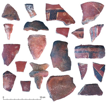
Fragments of ceramic wares classified as late Nasca, Estuquiña, and San Miguel (Arica I) cultural materials were infrequently noted among the surface findings, as well as a slightly larger amount of Chiribaya ceramic sherds. However, based on their form, manufacturing technology, and type of ornamentation, nearly 90% of the pottery found on the surface were classified as Tiwanaku ceramic wares (Figure 4). A significant proportion of the obtained ceramic material has a strongly eroded surface due to the humid environment typical of the fog oases that periodically occurred in both terraces. A layer of crystallized salt was also found on many fragments, including the Tiwanaku vessels.

Figure 4. La Pampilla 1: Tiwanaku materials collected from the surface (photos by Józef Szykulski). (Color online)
The Cultural Context
The multifaced excavations at La Pampilla 1 covered nearly 20% of the site surface and were concentrated close to the edge of the terrace, where fraudulent excavations left the least traces (Figure 2). This area is clearly visible from the town of La Pampilla below, which hindered the destructive activities of the huaqueros. Excavations were preceded by archaeological field reconnaissance and analysis of photographic documentation. This allowed for a preliminary estimate that the original cemetery consisted of 600–650 tombs and that it was divided into at least two distinct areas. The first covered most of the cemetery, whereas the other area was located close to its eastern edge, directly below the hillside leading to the upper terrace. Within the smaller sector, we recorded six destroyed stone-tomb structures—possibly shaft tombs covered with unidentified additional structure—that were noticeably larger than graves from the rest of the La Pampilla 1 site.
During the research, we uncovered and explored 81 tombs, of which 59 had partially or completely preserved burial contexts, which allowed most of them (47) to be classified as Tiwanaku. This group of 81 tombs also included 16 burial structures without contexts that we considered to be Tiwanaku because of their form and construction technique, as well as preserved structural elements of the grave cove. We also discovered 17 Chiribaya graves and a single burial probably related to early ceramic communities.
Our excavations at La Pampilla 1 confirmed that, in the region, the most frequently found grave type is an oval shaft with walls made of pebbles. This type was found in 17 unveiled graves recorded during archaeological field surveys and in 33 excavated graves identified as Tiwanaku. The stones are joined with clay mortar or laid out on cane weaves that separate individual layers of stones. The depth of the fully preserved shaft graves varies considerably, ranging from 61 to 135 cm. In one case (burial 51), an additional outer stone circle was found around the mouth of the shaft: this element has been frequently found in cemeteries in Moquegua region (Sharratt Reference Sharratt2011:212–213). It should also be emphasized that the excavated graves contain only single burials.
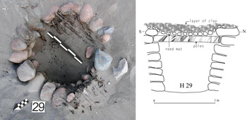
The covers of several Tiwanaku shaft tombs were made of poles, placed below the last or penultimate row of stones and covered with reed mats. A layer of clay or river mud was applied to the mats, and then the whole construction was covered with sand-clay sediment present on the surface. A partially preserved construction of this type was discovered during the exploration of burial 29 (Figure 5). In other cases, at the mouth of the shafts, remains of a pole protruding from the walls were found to have been preserved (burials 1, 3, 39, 46). Fragments of the cover were also recorded within the grave's filling material (burials 1, 8, 39, 41, 46, 74, 81). However, in the Chiribaya tombs registered within the La Pampilla 1 cemetery, we discovered stone slabs that served as shaft covers—as also found in Chiribaya tombs in other cemeteries in the region (Kołomański Reference Kołomański2016; Krajewska and Mikocik Reference Krajewska and Mikocik2014; Szykulski Reference Szykulski2010; Szykulski et al. Reference Szykulski, Figiel and Kwiatkowski2014, Reference Szykulski, Lewis, Wanot, Mikocik, Krajewska and Bewziuk2016).
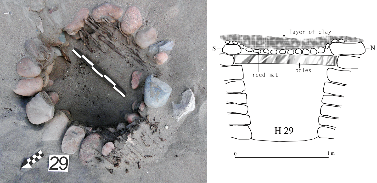
Figure 5. Capstone of burial 29 from La Pampilla 1 made of reed and poles, along with a cross section of the grave (photograph by Józef Szykulski). (Color online)
In the Tiwanaku burials from La Pampilla 1 in which we could determine the arrangement of the bodies, the deceased were found to be buried in the fetal position: the bodies were placed in a seated position, with the knees pulled up under the chin and restrained with ropes. This was inferred from the prints visible on the long bones of the skeleton and preserved soft tissue fragments, as well as the remains of plaited ropes inside the burial pits. Trace remains of plaited ropes were also recorded inside the burial chambers (burials 1, 13, 29, 52, 74). On the bodies, we also observed scraps of deteriorated textiles forming the funerary bundle (so-called fardo funerario).
The skeleton's position observed in 11 shafts confirms that the individuals were buried facing east. Two graves should be considered as exceptions—tomb 13, where the deceased was facing west, and tomb 50, where the body was facing north (Table 1). Furthermore, in burials 1 and 74, the body was found to be kept in a sitting position on a specially worked stone, and in the devastated grave 41, the western side of the bottom part was lined with six flat stones on which fragments of skeletal bones were recorded. In burial 24, we documented the custom of placing a kero-type vessel at the feet of the deceased, which was covered by a bowl-shaped vessel of a suitable diameter, likely to protect the contents of the kero cup. Other graves, disturbed by earthquakes and denudation processes, contained an overturned kero and a bowl-shaped vessel lying next to it (burials 39, 52).
Table 1. Elements of Tiwanaku Burial Contexts at La Pampilla 1.

Note: Burial cases where only the stone structure was preserved are not included.
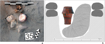
Some of the children's burials (infans I/II) that were found represent a distinct type of Tiwanaku tomb structure. In addition to the shaft tombs used, we noted the custom of burying the children's body in a shallow cavity surrounded by a circle formed of pebbles (Table 1). In burial 35, a circle formed by two layers of stones joined with clay mortar was also registered (Figure 6). Moreover, burials 27 and 49, which were several centimeters deep, had the form of a stone pavement, on which single broken vessels and bone fragments were found. Within burial 27 the vessel was in a form of jug, whereas in tomb 49 a censer (incensario) was recorded. These objects should probably be interpreted as destroyed structures in the form of partially stone-lined pits, similar to those found in the Moquegua Valley (Sharratt Reference Sharratt2011:197).

Figure 6. Burial 35 at La Pampilla 1: Infant burial (a) with a cross section of the grave (b). In the center of the shaft a kero covered with a bowl-shaped vessel was found (photograph by Józef Szykulski). (Color online)
The skeleton bones preserved in the children's graves indicate that the deceased infants were buried in the same position as adults: with their knees pulled up under the chin. The skeleton layout documented in two graves indicates that the children were buried facing east (burials 11, 37; see Table 1). In burial 35, the contents of the grave included a kero cup with a fitted bowl-shaped vessel placed on it, whereas in others a single kero or bowl was placed inside the tombs (Figure 6). The degradation of the osteological material does not permit determining whether different forms of vessels in particular tombs define the sex of the children.
Within the preserved sepulchral contexts, one or two vessels were observed, and only in burial 74 were a kero cup and two censers (incensarios) found (Figure 7:III). In addition to pottery, the graves also occasionally contained other artifacts. However, wares made of organic matter were preserved in a residual state, which indicates that a significant proportion had already decomposed. Among the registered artifacts were wooden spoons, weaving combs, chrysocolla beads, guinea pig bones, several fragments of gourd containers, and remains of hard-to-define bone and wooden artifacts (Table 1).
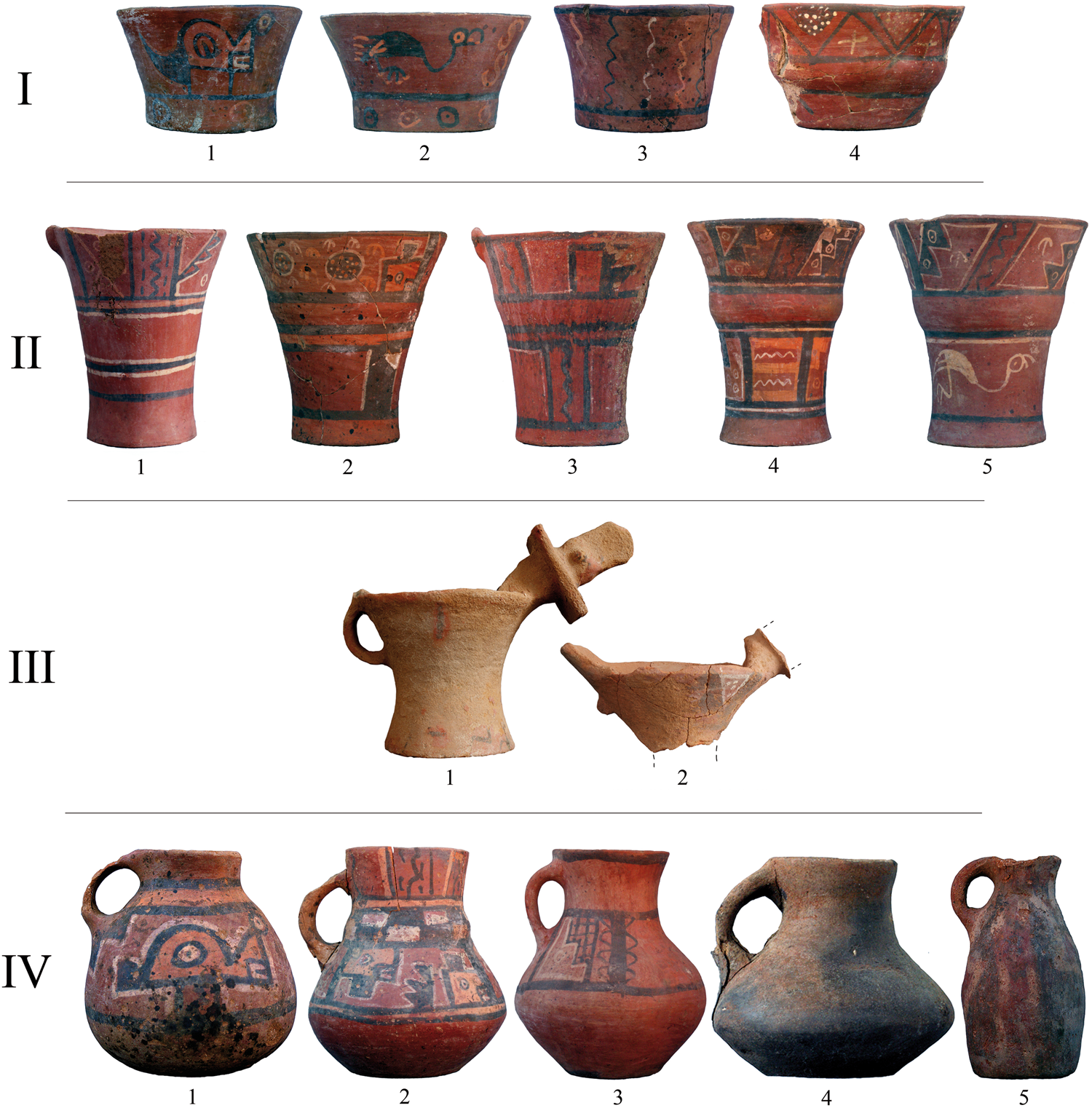
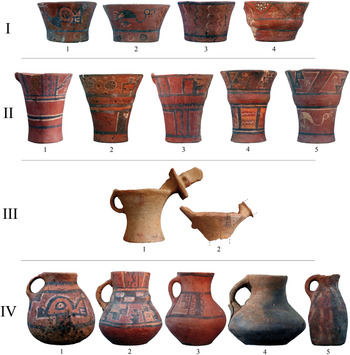
Figure 7. Typology of Tiwanaku vessels unearthed at La Pampilla 1 archaeological site (photos by Józef Szykulski). (Color online)
Tiwanaku ceramic wares documented within the La Pampilla 1 archaeological site are characterized by diversity in manufacturing technology and ornamentation style. In some vessels with a rough surface, visible shortcomings in the molding and firing processes were noted, as well as carelessly made painted ornamentation limited to simple linear iconographic motifs. Undoubtedly, these wares represent local utilitarian pottery produced within the households.
However, most of the vessels found in the graves and most of the fragments from surface finds (about 80%–85%) exhibit the characteristics of good-quality Tiwanaku pottery in terms of manufacturing and firing technology, as well as ornamentation type. The basic forms are jugs of a spherical or elongated shape, bowl-shaped vessels, and keros (Figure 7). Among the keros, in addition to ceramic wares having standard sizes, we found examples that significantly exceed the dimensions and proportions of vessels found during the period of the Tiwanaku state in the Altiplano area and among the materials of the Omo and Chen Chen phases from the Moquegua region. Among the investigated cemetery zoomorphic vessels, we also found handled goblets with a modeled depiction of a bird of prey (condor/eagle) in a plastic form placed within the spout. Two such vessels were discovered in burial 74 (Figure 7:III), and a fragment of another was found within the devastated grave 49. We also found fragments of this type of pottery among surface findings (Figure 4) from the aforementioned devastated tombs of larger sizes in the eastern sector of the cemetery, located directly below the hillside leading to the upper terrace (see Figure 2). Vessels of this type, referred to as censers (incensarios), are only occasionally found in burial contexts related to the Tiwanaku culture.
The painted iconography of Tiwanaku ceramics from the La Pampilla 1 cemetery is represented mainly by geometric motifs (points, circles, horizontal and diagonal lines, trusses, wavy lines, crosses, and stepped ornamentation), as well as by the stylized representation of the pupil of the eye in a concentric form. We also observed zoomorphic iconography depicting flamingos or feline heads yet noted no images of the entire animal body. Red, orange, white or cream-white, and black dyes were used in the painted ornamentation of ceramic vessels (see Figure 7). It should be emphasized that in the Tiwanaku burial contexts from La Pampilla 1 site, we found no evidence of intrusive formative ceramic wares (Islay) or Chiribaya materials. Moreover, no Tiwanaku pottery was found within Chiribaya graves from the investigated cemetery nor from other burial sites in the region in question (Kołomański Reference Kołomański2016; Reference Kołomański2018; Krajewska Reference Krajewska2016).
The Chronology Issue
In our exploration of burial contexts from the La Pampilla 1 cemetery, we collected organic material and conducted five 14C analyses (Figure 8). Calibration of radiocarbon dates was performed based on the IntCal13 atmospheric curve (Reimer et al. Reference Reimer, Bard, Bayliss, Beck, Blackwell, Ramsey, Buck, Cheng, Edwards, Friedrich, Grootes, Guilderson, Haflidason, Hajdas, Hatté, Heaton, Hoffmann, Hogg, Hughen, Kaiser, Kromer, Manning, Niu, Reimer, Richards, Scott, Southon, Staff, Turney and van der Plicht2013) and the SHCal13 atmospheric curve (Hogg et al. Reference Hogg, Hua, Blackwell, Niu, Buck, Guilderson, Heaton, Palmer, Reimer, Reimer, Turney and Zimmerman2013) at intervals of 1σ (68.2%) and 2σ (95.4%). No significant differences in the values of the obtained intervals were found. However, a comparison of the results obtained based on both calibration methods indicates that the SHCal13 atmospheric curve obtained a slightly later time interval (Table 2).

Figure 8. Probability curve for the radiocarbon dates obtained for La Pampilla 1 site.
Table 2. Compilation of All Calibrated 14C Dates from Burial Contexts of La Pampilla 1.

Note: Poznan Radiocarbon Laboratory (POZ).
At the La Pampilla 1 site, the analyzed samples came from chronologically diverse burial contexts, making it possible to associate individual radiocarbon dates with various communities using the cemetery area during different periods of the precolumbian era. Burial 60 has the earliest dating: third–fourth century AD (1σ, 68.2%). This corresponds to the earliest dating from the El Pino 7 site located to the south of La Pampilla 1, where the Islay burial contexts associated with the agricultural, early ceramic community were found (Szykulski Reference Szykulski2017).
However, for Tiwanaku-related burial contexts, we retrieved dates of eleventh–twelfth century AD from graves 21 and 46. In grave 29, where a vessel identified as a local imitation of Tiwanaku pottery was found, the radiocarbon result indicates a date of twelfth–thirteenth century AD (Table 2). These obtained values seem relatively late. However, when compared with the results of the radiocarbon analyses for Tiwanaku sites in Moquegua region, they do not differ from the time intervals recorded for the terminal Middle Horizon Tumilaca populations (Owen and Goldstein Reference Owen and Goldstein2001:174; Sharrat Reference Sharratt2019).
In La Pampilla 1, we also obtained a 14C date of thirteenth–fourteenth century AD—with a clear tendency toward the fourteenth century—for burial 63, which contained Chiribaya materials and an Estuquiña vessel. This chronological range coincides with the results of 14C datings of Chiribaya cultural materials from the cemetery of El Pino 4, which is located south of La Pampilla 1 (burials H18 and H26). The radiocarbon dating of organic matter from El Pino 4 indicates the fourteenth century AD (Kołomański Reference Kołomański2018:54; Szykulski et al. Reference Szykulski, Lewis, Wanot, Mikocik, Krajewska and Bewziuk2016:75). In the context of the chronology adopted for the Chiribaya culture, all three dates—the only radiocarbon dates related to the contexts of Chiribaya culture from the Tambo estuary—are in the culture's late or declining period of development (Buikstra Reference Buikstra and Wise1998; Lozada and Buikstra Reference Lozada and Buikstra2002; Lozada et al. Reference Lozada, Mogrovejo and Buikstra2009).
Discussion
The research at La Pampilla 1 provides evidence for the movement of postcollapse Tumilaca communities to the area north of the Osmore-Moquegua Valley. At the same time, the discovery of such an extensive cemetery indicates the existence of a relatively large community practicing Tiwanaku traditions within the Tambo estuary. This claim may be reinforced by the limited surface finds from Pampa Blanca and La Pampilla 2 sites (Krajewska and Mikocik Reference Krajewska and Mikocik2014:145, 155); the fragments of an anthropomorphic Tiwanaku kero cup registered within the Carrizal 1 site in the Yalaque (Szykulski Reference Szykulski, Banaszkiewicz, Kara and Mamzer2013:410); and ceramic wares in the collection of the Museo Arqueológico de la Universidad Católica Santa María in Arequipa that were from the Arenal cemetery, which was destroyed in the twentieth century (Figure 3). The ceramic wares from the previously mentioned Arenal cemetery, in addition to the typical Tiwanaku forms and high-quality production technology, are characterized by the iconography of the Chen Chen ceramic style from the Moquegua Valley (Owen and Goldstein Reference Owen and Goldstein2001:Figure 5), which was continued by the Tumilaca communities (Bermann et al. Reference Bermann, Goldstein, Stanish, Watanabe, Rice, Stanish and Scarr1989; Owen Reference Owen2005; Sharratt Reference Sharratt2011). However, because Tiwanaku settlement sites have not yet been discovered in the Tambo Valley, the structure and form of the settlement in this region, as well as its beginnings, remain open to question.
The form of burial structures found in La Pampilla 1 seems to be characteristic for the Tiwanaku cemeteries both from the Lake Titicaca basin (Isbell and Korpisaari Reference Isbell and Korpisaari2012; Korpisaari Reference Korpisaari2006) and from the Osmore-Moquegua Valley, from the Chen Chen burial site dated to the state period of Tiwanaku development, and from Tumilaca la Chimba cemetery used by postcollapse Tumilaca communities (Sharratt Reference Sharratt2011; Sharratt et al. Reference Sharratt, Williams, Lozada, Starbird, Vranich, Klarich and Stanish2012; Williams et al. Reference Williams, Moseley, Lozada and Sharratt2006). This similarity applies to both shaft graves and stone-lined pits, although in the case of shaft graves from the Altiplano region and the Moquegua Valley, there is no information about the prevalence of covers constructed from organic materials found for several tombs in La Pampilla 1 cemetery. In contrast, the additional stone circle registered around the mouth of the shaft of grave 51 from La Pampilla 1 is a construction found relatively often within the Tumilaca tombs from the Moquegua Valley (Sharratt Reference Sharratt2011:Figure 30; Williams et al. Reference Williams, Moseley, Lozada and Sharratt2006). However, the practice of placing the body in a sitting position on a worked stone observed within La Pampilla 1 is only confirmed for the Tumilaca la Chimba cemetery in Moquegua (Sharratt Reference Sharratt2011; Williams et al. Reference Williams, Moseley, Lozada and Sharratt2006). Additionally, the tradition of burying bodies facing east recorded in the 14 tombs of La Pampilla 1 is a common practice observed in Tiwanaku-state cemeteries in the Altiplano area, such as the Lucurmata (Goldstein Reference Goldstein2005:245). This tradition also occurs in Moquegua region, where it has been confirmed for most Chen Chen M1 burials (Blom Reference Blom1999:80; Blom et al. Reference Blom, Hallgrímsson, Keng, Lozada and Buikstra1998), and was cultivated by the postcollapse Tumilaca communities (i.e., within the Tumilaca la Chimba cemetery; Sharratt Reference Sharratt2016a, Reference Sharratt and Faulseit2016b; Williams et al. Reference Williams, Moseley, Lozada and Sharratt2006).
Interpreting the spatial layout of the La Pampilla cemetery requires further work to determine whether the noticeable division of the cemetery into two sectors—one including most of the examined cemetery area, and the other a cluster of larger tomb structures on its eastern edge—results from the different phases of its use or instead reflects social divisions within the local kin groups, or ayllus, as is assumed for the Moquegua region (Blom Reference Blom1999; Goldstein Reference Goldstein2005; Isbell and Korpisaari Reference Isbell and Korpisaari2012:110). However, given the location, size, and limited number of graves in the eastern part of the cemetery, it seems more reasonable to speculate that we are dealing with social stratification of the local postcollapse society.
Regarding the Tiwanaku ceramic wares from La Pampilla 1 site—apart from the utilitarian vessels that are difficult to classify in terms of ornamentation stylistics and chronology (burials 11, 12, 17, 29, 50)—we can classify most as late materials. Thus, they were associated with the period immediately following the collapse of the political and economic structure in the Lake Titicaca basin, around AD 1000. The forms of the vessels and the painted ornamentation appearing on their surface are similar or even identical to Ilo-Tumilaca/Cabuza wares from El Algodonal (Owen Reference Owen2005:Figure 4) and to materials belonging to the Tumilaca style from Moquegua; that is, those found at the Tumilaca la Chimba site (Sharratt Reference Sharratt2011, Reference Sharratt2019). In the inventories from La Pampilla 1, we also found “oversized” keros, a characteristic of Tiwanaku-Tumilaca pottery from the Osmore-Moquegua basin.
The limited number, fragmentary state of preservation, and insignificant typological differentiation of the grave goods, other than ceramic wares, found in the burial contexts of the La Pampilla 1 cemetery, do not enable much interpretation possibilities (Table 1). However, gourd containers and several chrysocolla beads were found among the burial contexts of the Tumilaca la Chimba cemetery in the Moquegua Valley (Sharratt Reference Sharratt2011:206). Furthermore, at least with regard to the wooden spoon from burial 39, a clear resemblance to analogous artifacts from the Ilo-Tumilaca/Cabuza burial contexts of Moquegua can be seen (Owen Reference Owen2005:Figure 13; AD 378). At the same time, the practice of placing a kero covered with a bowl-shaped vessel next to the deceased—as in burials 24, 35, and probably 39 and 52 in the La Pampilla 1 cemetery—may suggest that Tiwanaku burial vessels contained food or drinks (Korpisaari Reference Korpisaari2006:39–52). This hypothesis is strengthened by the presence of guinea pig bones in burials 7, 50, and 74 (Table 1).
Therefore, the most logical conclusion seems to be that the settlement of Tiwanaku in the area of the Tambo River delta should be associated with the settlement expansion of so-called second-stage diaspora populations from the Osmore-Moquegua Valley (Owen Reference Owen2005). Expansion of the population groups is represented by the Tumilaca or Ilo-Tumilaca/Cabuza materials associated with postcollapse Tiwanaku-Tumilaca communities. This is confirmed not only by the stylistic and typological analysis of the ceramic wares but also by the results of radiocarbon dating from the La Pampilla 1 archaeological site (Table 2), which coincide with the results of 14C dating of Tumilaca-style materials from Moquegua (Owen and Goldstein Reference Owen and Goldstein2001:174). At the current stage of research, there are no convincing arguments for the hypothesis that the origins of Tiwanaku in the lower part of the Tambo River coincide with the period preceding the second-stage diaspora and the collapse of the Tiwanaku state.
Conclusion
Archaeological research conducted within La Pampilla 1 cemetery confirms the presence of a relatively large population from the terminal phase of Tiwanaku culture in the Tambo delta, represented by Tumilaca materials related to the second-stage diaspora (Owen Reference Owen2005). This observation is reinforced by earlier finds of Tiwanaku materials from the Pampa Blanca, La Pampilla 2, Arenal, and Carrizal 1 archaeological sites (Figure 3; Krajewska and Mikocik Reference Krajewska and Mikocik2014). It is the first time that such an extensive funerary Tiwanaku site was registered directly in the Pacific coastal zone. At the same time, results of the 14C calibrated analyses place the Tiwanaku contexts from La Pampilla 1 in the eleventh–thirteenth centuries AD (Table 2), which is consistent with radiocarbon dating of Tumilaca-phase materials from the Moquegua region (Owen and Goldstein Reference Owen and Goldstein2001). The forms of the burial structures, the manner of burying the dead, and the shapes and iconography of the Tiwanaku vessels from the La Pampilla 1 cemetery are very similar to the cultural contexts recorded within the Tumilaca la Chimba site in Moquegua (Sharratt Reference Sharratt2011, Reference Sharratt2016a; Williams et al. Reference Williams, Moseley, Lozada and Sharratt2006). At the same time, there are also visible differences, as in the case of organic capstones registered within some tombs from La Pampilla 1 that were not recorded in Moquegua Valley.
The research results so far do not indicate that the postcollapse Tumilaca communities from the Tambo Valley had interacted with members of the agricultural-ceramic Islay society that previously lived in this area. All radiocarbon dates for the Islay culture significantly precede the results obtained for the Tiwanaku contexts in the Tambo River delta (Szykulski Reference Szykulski2017:297–299). There is no evidence of any connection between several Nasca Tardío pottery sherds recorded on the surface of La Pampilla 1 cemetery with the terminal Tiwanaku burials.
The results of the excavations carried out in the area of the Tambo River estuary indicate that postcollapse Tumilaca societies there had disappeared even before the expansion of the Chiribaya community, whose burials were recorded within numerous cemeteries in the region (Kołomański Reference Kołomański2016; Krajewska and Mikocik Reference Krajewska and Mikocik2014; Szykulski et al. Reference Szykulski, Lewis, Wanot, Mikocik, Krajewska and Bewziuk2016). Thus, in contrast to the results of research conducted in the area of the Osmore-Moquegua estuary—which confirmed the coexistence of Tiwanaku and Chiribaya communities (Owen Reference Owen2005)—there is no evidence of direct interaction between these two culturally different human groups in the area of the Rio Tambo. The results of radiocarbon analyses of the funeral contexts of Tiwanaku and Chiribaya cultures within the river valley in question support this conclusion (Table 2; Kołomański Reference Kołomański2016, Reference Kołomański2018; Szykulski et al. Reference Szykulski, Lewis, Wanot, Mikocik, Krajewska and Bewziuk2016).
Acknowledgments
We thank the following institutions and people for helping our research in the Tambo River delta. The Commission of the Seventh Framework Programme of the European Union (Marie Curie-Skłodowska Action), the Ministry of Science and Higher Education–Poland, the Ministry of Culture and National Heritage–Poland, the Municipalidad Provincial de Islay at Mollendo, and the Bank Zachodni WBK Foundation (currently Bank Santander)–Program Santander Universidades provided generous financial support. We thank the rector and deans of the University of Wrocław and Universidad Católica de Santa Maria, Arequipa; the officials of the Ministry of Culture of Peru, Dirección Desconcentrada de Cultura in Arequipa and Moquegua; all those participating in fieldwork, office work, and laboratory analysis of materials; and the inhabitants of the Tambo River delta, who hosted our team.
Data Availability Statement
All analyzed materials are housed at the Museo Arqueológico de la Universidad Católica de Santa María (Calle Cruz Verde 303, Arequipa) and Museo Arqueológico de la Universidad Nacional de San Agustín de Arequipa.


 Open access