


Introduction
Ever since pits containing charred stones were first discovered, archaeologists have been puzzled by them. Translated from the German and Scandinavian languages as ‘cooking stone pits’, the term may imply that the pits were used for cooking. Yet it merely describes pits containing stones ‘cooked’ and cracked by heat. Despite the confusing label, this term has entered the German and Scandinavian literature and we must accept it.
The German archaeologist Wilhelm Deecke was one of the first to mention ‘fire pits’ in his ‘Notes on fire pits in New Pomerania’ (translated: Deecke, Reference Deecke1906, cited in Hüser, 2011: 96). Often, however, they were not recognized as such. In the card index of the Cultural Heritage Department of Schleswig-Holstein, descriptions from the twentieth century of ‘strange stone-filled fireplaces’ can be found repeatedly. and If these recorded at all, they were interpreted as hearths, settlement features, or graves (e.g. Hamburg-Sinstorf 3 or Hollenstedt 1; Hüser, 2011: 107 and 113 respectively). In the last decades, especially since the 1970s, rows of cooking stone pits were discovered in increasing numbers (Schmidt & Forler, Reference Schmidt and Forler2003: 24). Extensive research on their distribution, assemblages, and dating followed (e.g. Honeck, Reference Honeck2009; Schmidt, Reference Schmidt, Jantzen, Saalow, Schmidt and Dworžak2014; Kruse & Matthes, 2019).
In general, the cooking stone pits (CSPs hereafter; also variously labelled cooking pits, cult fireplaces, burning pits, fire pits, or oven pits) are pits that are usually circular, oval, elongated, and sometimes also rectangular. Their profile is concave to trough-shaped. Their contents differ fundamentally from that of normal hearths (see below). The CSPs usually appear in rows or amorphous arrangements and are found generally separate from cemeteries or settlements, occupying their own space in the landscape, and located on prominent and sandy plateaus, hills, or lowlands near water. Sometimes, however, they are clearly related to sites, as for example at the cemetery of Mang de Bargen in Schleswig-Holstein (Figure 1).

Figure 1. Location of Mang de Bargen (Bornhöved, district of Segeberg) in northern Germany.
The pits’ contents are generally limited to charcoal, ash, and more or less strongly charred stones, which are densely packed in the pits’ fills (Heidelk-Schacht, Reference Heidelk-Schacht and Schlette1989: 225–40; Kristensen, Reference Kristensen2008: 9; Honeck, Reference Honeck2009: 10–12; Schmidt, Reference Schmidt, Jantzen, Saalow, Schmidt and Dworžak2014: 145; Løvschal & Fontijn, Reference Løvschal and Fontijn2019: 140–41). As their name implies, the pits are interpreted as having been used for cooking. Such an interpretation, however, remains conjectural; cooking in these pits is not so far supported by strong evidence. Their function is subject to debate and ranges from a profane to a ritual use, from the preparation of food to ancestor worship or even to saunas (Honeck, Reference Honeck2009: 21–23; Schmidt, Reference Schmidt, Jantzen, Saalow, Schmidt and Dworžak2014: 154; Kruse & Matthes, 2019: 209, 223–28). Comparable features have been found in Ireland (fulacht fiadh) and Britain (burnt mounds). These are mainly connected to food preparation, but have also been interpreted in similar ways to CSPs (Brown et al., Reference Brown, Davis, Hatton, O'Brien, Reilly and Taylor2016; Johnston, Reference Johnston2021: 145–48). Here, I present the latest results from the Mang de Bargen site and link it to previous research on Bronze Age CSPs in northern Germany and southern Scandinavia.
Case study: The Cemetery of Mang de Bargen
Within the ‘Scales of transformation – Human-environmental interaction in prehistoric and archaic societies’ project of the Collaborative Research Centre 1266 of the University of Kiel (Fuchs et al., Reference Fuchs, Kirleis and Müller2019), CSPs were found in 2016–2019 both within the cemetery of Mang de Bargen (Bornhöved, district of Segeberg in Schleswig-Holstein, northern Germany) and in its vicinity (Schaefer-Di Maida, Reference Schaefer-Di Maida2018b: 32–34).
The cemetery was used for burials from the Late Neolithic to the pre-Roman Iron Age. During the Late Neolithic (c. 2200–1800 bc) and the Early Bronze Age (Nordic Bronze Age Period I–III: 1800–1100 bc), twenty burial mounds were built. From the Late Bronze Age onwards (Nordic Bronze Age Period IV–VI: 1100–530/500 bc), fifty-nine cremations were buried in urns and small stone structures in the areas occupied by the burial mounds. An urnfield close to the burial mound zone started in the pre-Roman Iron Age (main phase of use: 530/500–90 bc) with 201 individuals buried there. Some features indicative of settlement, such as pits, postholes, and an oven, were found over the entire area located between the burial mounds and on the urnfield. Single CSPs were found in the cemetery and two CSP clusters were discovered not far from it (Figure 2).

Figure 2. Map of the site of Mang de Bargen (data from Lütjens, Reference Lütjens2014).
Cooking stone pits in the cemetery
On the cemetery site, twelve CSPs were found. Their shapes vary from circular to elongated. Their fill, consistently comprising charcoal-containing earth and heated stones, suggests they had a similar use (Supplementary Material: Table S1).
In part, the pits appear to be spatially related to the graves, but elsewhere they are located away from the burials (Figure 3; Table S1). Given that some pits are close to graves, they may possibly have served as a meeting place for a funeral (see below) but, since no dating samples are available from these features, their phasing remains unclear. Nevertheless, because of their proximity to each other, some isolated CSPs may reference urn graves, which in turn may suggest a common date in the Late Bronze Age (Nordic Bronze Age Period IV–VI: 1100–550/500 bc). A connection between the burial of certain individuals and the construction of a CSP must, however, remain conjectural since there is no direct evidence of such a link.

Figure 3. Location of CSPs at the cemetery of Mang de Bargen.
Cooking stone pits outside the cemetery
During the project, the outer areas of the cemetery were investigated using geophysical prospection methods, fieldwalking surveys, and test excavations (Schaefer, Reference Schaefer2017; Schaefer-Di Maida, Reference Schaefer-Di Maida2018a). Two CSP areas were attested by the presence of anomalies in the magnetometry surveys. One of these areas was located about 100 m north of the cemetery and consisted of a fairly regular row of possible CSPs (Figure 4). The second area was located 500 to 600 m north-west of the cemetery in a depression. Some 250 anomalies were detected there, in an area covering 4300 m2; they appear arranged in twenty to twenty-five circles and semicircles of around 6–8 m diameter each comprising different numbers of CSPs (Figure 5).

Figure 4. Geomagnetic map of the CSPs in a row, c. 100 m north of the cemetery of Mang de Bargen.

Figure 5. Geomagnetic map of CSPs in circular arrangements at Mang de Bargen.
Three test trenches, designed to cut three CSPs in different circle arrangements, revealed circular to oval to trough-shaped pits, approximately 0.4 m deep and 0.75–0.80 m wide, filled with heated stones and ash-containing soil (Figure 6). In the first 3 × 3 m test trench, CSP 1_2017 was embedded in a cultural layer containing pottery, some flint artefacts, and a green glass bead. Further test trenches revealed an upper layer with numerous stones and some finds stratigraphically separated from a lower layer into which the CSPs were cut. The upper cultural layer is probably the eroded remains of a Late Bronze Age urnfield located to the west below a slope (Figure 2) and probably deposited over time above the CSP area, dated here to the Middle Bronze Age (unlike the possibly Late Bonze Age CSPs in the cemetery) by radiocarbon dating of charcoal in some of the pits fills (see below).
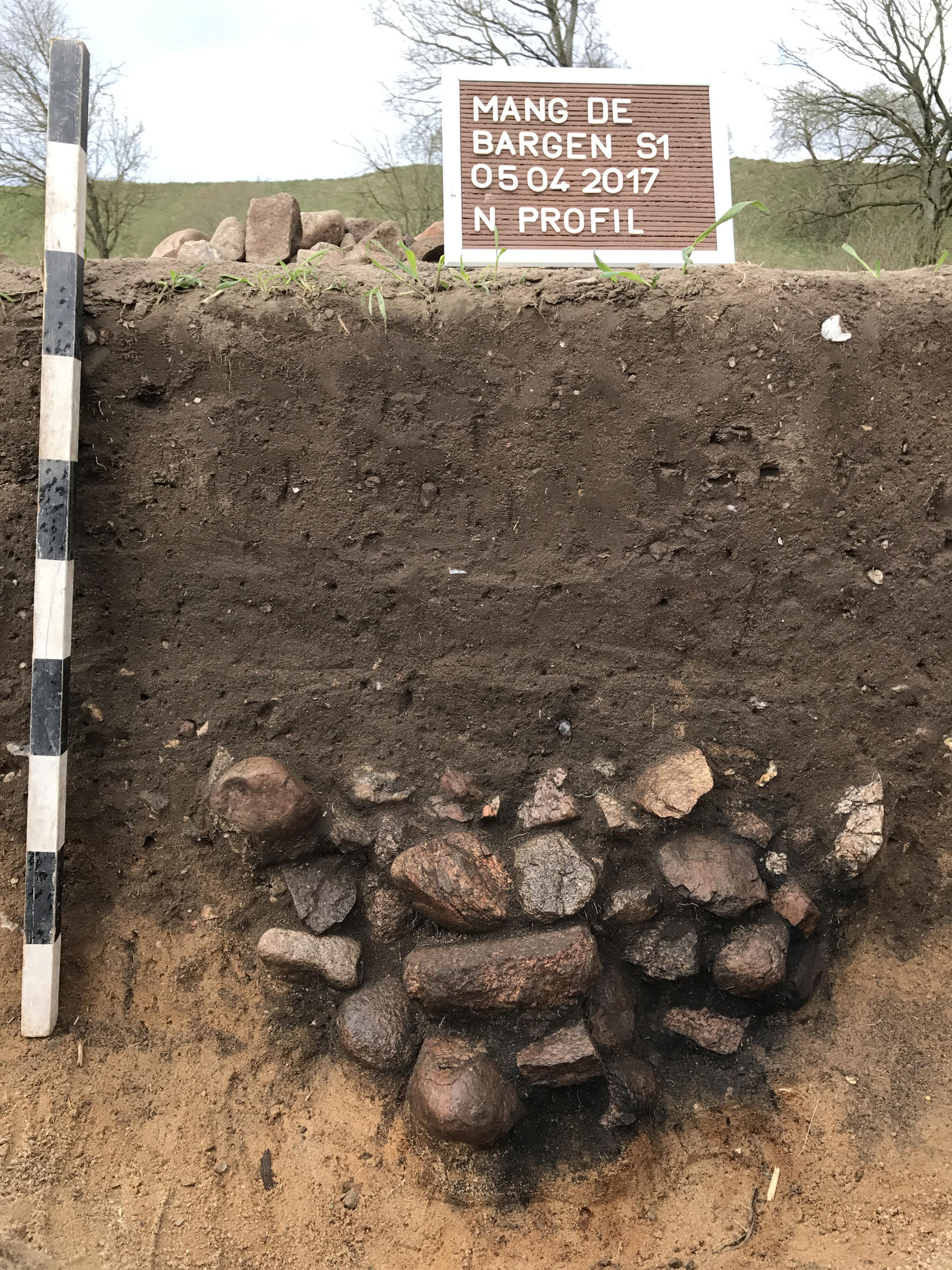
Figure 6. Section of a cooking stone pit in the circular arrangements at Mang de Bargen.
The excavated CSPs showed some charcoal concentrations in section; we presume that the fire was located between the stone layers (see below). At the upper edge of the pits (partly amorphous in plan), some more stones were located outside the pits, possibly from opening them, though for what reason is unclear. Possibly they were opened to remove food that had been cooked in them but no evidence, such as food remains, was recovered from the pits. The position of the stones in the pit indicates that the pits were initially lined with larger stones (on average 10 cm long and 5–6 cm wide), while smaller stones (about 5–6 cm long and 2–3 cm wide) filled the centre. Very small stones of less than 1 cm filled the gaps, making the packing very dense. We suggest that a fire was lit underneath the small stones and then sealed with them. If the pits were used for food preparation, food placed between the smaller stones could thus be removed without needing to move the larger stones.
The charcoal from the pits indicates that mainly hazel (Corylus) and oak (Quercus) were used to light the fire in the pits. The charcoal samples were radiocarbon-dated and showed an overall period of use between 1400 and 1100 cal bc (Figure 7). Due to dates being available from only two excavated pits, it is not yet possible to estimate a period of use for the CSP field as a whole.

Figure 7. Calibrated radiocarbon dates from the excavated CSPs at Mang de Bargen (at 95.4% confidence).
The use of hazel in CSPs is paralleled around 1300 bc by an increase in hazel in the pollen profile of Lake Belau (located c. 3 km north of the site) and the peat bog of Mang de Bargen (c. 0.5 km north of the site). It seems likely that an increase in pastoralism played a role in the opening of the forests (Feeser et al., Reference Feeser, van den Bogaard and Dörfler2020). Hazel was therefore present in the immediate vicinity of the CSP field. Oak, on the other hand, appears to be declining (Feeser et al., Reference Feeser, van den Bogaard and Dörfler2020: table 2). It is probable that the pieces of oak recovered in the CSPs were remnants of timber not used as building material. The latter is also suggested at the site of Egelund III (southern Jutland; Kruse & Matthes, 2019: 214), where charcoal analyses by Bartholin and Mikkelsen (Reference Bartholin and Mikkelsen2015) showed that there was probably no selection of wood for fuel.
The cooking stone pits at a supra-regional level
Cooking stone pits are found all over northern Germany, Denmark, southern Sweden, and north-western Poland and reach as far as northern Saxony-Anhalt, bordering on a zone containing the ‘Central German stoneless pit rows’ (according to Schunke, Reference Schunke2017). Here, I focus on the northern German and Danish findings, with comparison drawn from adjacent regions.
The northern pits, variously known as fire pits, Koch(stein)gruben, koge pits, kokgrop, or kokegrop, can take the form of single or several rows, groups (certain pits occur close together but without further patterning), circles, or irregular arrangements (Schmidt & Forler, Reference Schmidt and Forler2003; Kristensen, Reference Kristensen2008; Honeck, Reference Honeck2009; Schmidt, Reference Schmidt, Jantzen, Saalow, Schmidt and Dworžak2014; Kruse & Matthes, Reference Kruse and Matthes2017, 2019). The distribution of these formations (Figure 8) also includes single and uncertain findings to show that some pit configurations are still undefined or without recognizable pattern.
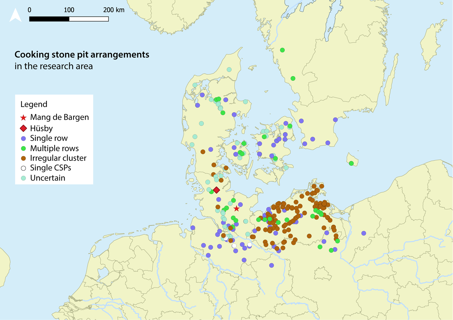
Figure 8. Distribution of CSPs in northern Germany and parts of southern Scandinavia according to their arrangements (data from: Schmidt & Forler, Reference Schmidt and Forler2003; Kristensen, Reference Kristensen2008; Honeck, Reference Honeck2009; Schmidt, Reference Schmidt, Jantzen, Saalow, Schmidt and Dworžak2014; Kruse & Matthes, Reference Kruse and Matthes2017, 2019).
The distribution also reflects the different levels of research and different ways of recording. Depending on the excavator, CSPs exhibiting no obvious pattern may be recognized and discussed or remain hidden. In Schleswig-Holstein, Denmark, and southern Sweden the distribution is relatively even with moderate concentrations. In Mecklenburg-Western Pomerania, on the other hand, investigations are extensive and constantly augmented by new geophysical surveys by various projects (Cluster of excellence ROOTS; CRC1266; state agency investigations).
In Mecklenburg-Western Pomerania unstructured groups appear to be more frequent than rows. According to Schmidt (Reference Schmidt, Jantzen, Saalow, Schmidt and Dworžak2014: 148) and Schmidt and Forler (Reference Schmidt and Forler2003: 23), the two types (type 1: fireplaces in rows; type 2: fireplaces in irregular patterns) can be separated chronologically, and later configurations consist of pit groups that replace the earlier row arrangements.
Looking at the distribution of the two types, it seems that the CSPs around Mang de Bargen are arranged in rows and are more likely to be present than irregular ones. In the Hamburg area, irregular groups of pits are also rarer, where row arrangements and single CSPs predominate. In northern Jutland, the Danish islands, and southern Sweden CSPs are mainly in rows (Kristensen, Reference Kristensen2008). In northern Schleswig and southern Jutland the opposite is true, with CSPs in unstructured groups dominant. Only two rows, of single-row type, are known at Søderup and Skelde Overballe (Kruse & Matthes, 2019: 209). Overall, there seems to be a tendency towards row arrangements in the north of the distribution of CSPs, while in Mecklenburg-Western Pomerania, southern Jutland, and partly in the Hamburg area there are irregular clusters of CSPs.
Are the patterns described regional phenomena or is this distribution due to an insufficient state of research? Linear construction projects (i.e. Intercity lines, motorways, etc.) are, for example, less intensively investigated archaeologically in Schleswig-Holstein than in Mecklenburg-Western Pomerania, and, in general, pit rows are more easily recognized and documented than irregular arrangements, as the former have a distinct linear structure while the latter are only visible as areas of discolouration (Schmidt & Forler, Reference Schmidt and Forler2003: 24). In Mecklenburg-Western Pomerania, recent intensive investigations indicate that CSPs in rows are located away from settlements or cemeteries, while CSPs in irregular configurations (‘heaps’ or unstructured groups) may be related to settlements and thus may point to production areas (Schmidt, Reference Schmidt, Jantzen, Saalow, Schmidt and Dworžak2014: 148).
The occurrence of CSPs in circular arrangements is so far only known from the vicinity of Mang de Bargen and at Hüsby (Meier, Reference Meier, Heske, Nüsse and Schneeweiß2013), where additional row arrangements and irregular pits occur. The two sites are about 70 km distant from each other and hence are not necessarily a regional characteristic. While in the Mang de Bargen complex many smaller circles of about 6–8 CSPs have been identified, at Hüsby only one circular arrangement of multiple CSPs has been recorded (Meier, Reference Meier, Heske, Nüsse and Schneeweiß2013: 321). However, a closer look at the geomagnetic results from Hüsby reveals that anomalies also occur there, in several small circles forming a large circle; this arrangement is therefore comparable with the findings at Mang de Bargen.
For the sake of completeness, CSPs are also known from Norway and date from 1000 bc to ad 600/700 (Gustafson, Reference Gustafson, Gustafson, Heibreen and Martens2005a: 7–8; Narmo, Reference Narmo, Gustafson, Heibreen and Martens2005: 191–206). They are found in connection with cult sites (Gustafson, Reference Gustafson, Gustafson, Heibreen and Martens2005b: 109–12), settlements (Gustafson, Reference Gustafson, Gustafson, Heibreen and Martens2005c: 116–18), rivers (Gustafson, Reference Gustafson, Gustafson, Heibreen and Martens2005d: 125–29), and valleys (Gustafson, Reference Gustafson, Gustafson, Heibreen and Martens2005e: 130–34), but a discussion of their function lies outside the scope of this study.
In contrast to the northern CSPs, the pits in central Germany (Saxony/Saxony-Anhalt) are rather elongated, almost rectangular, and do not contain heated stones (Schunke, Reference Schunke2017: 79–94). They are therefore not classified as CSPs and—not least because their rows partly converge to form networks in the landscape—probably had a different function as boundaries. Geographically, the two pit types are adjacent to each other but do not overlap. However, they belong in the same timeframe. Comparable pit alignments are also known from Great Britain (Løvschal & Fontijn, Reference Løvschal and Fontijn2019: 143-44.).
Chronology
Initially, CSPs were often uncritically attributed to the Late Bronze Age because the first absolute dates obtained for CSPs tended to fall in that period. Yet, dating based on surrounding or adjacent features, such as graves or settlement features, has been demonstrated as inadequate by many sites whose CSPs were either earlier or later than all neighbouring features (e.g. at Zedau; Heidelk-Schacht, Reference Heidelk-Schacht and Schlette1989: 228).
More precise dating of CSPs (first undertaken for example by Durmann & Obelić, Reference Durmann and Obelić1989: 1003–09; Raczky et al., Reference Raczky, Hertelendi, Horváth and Meier-Arendt1992: 42–47; Rasmussen, Reference Rasmussen1999: 310–26; Lagerås & Strömberg, Reference Lagerås and Strömberg2005; Schmidt, Reference Schmidt and Meier2005: 71–76) has developed in the last decades in the context of extensive investigations and absolute dating. Figure 9 gives an overview of the CSPs in the different regions, with only 14C-dated CSPs included, omitting sites with pits that may be earlier or later than their surrounding features.

Figure 9. Dating of CSPs in northern Germany and southern Scandinavia (data from: Thrane, Reference Thrane1974; Schmidt & Forler, Reference Schmidt and Forler2003; Henriksen, Reference Henriksen, Gustafson, Heibreen and Martens2005; Kristensen, Reference Kristensen2008; Honeck, Reference Honeck2009; Hüser, 2011; Schmidt, Reference Schmidt2012; Meier, Reference Meier, Heske, Nüsse and Schneeweiß2013; Schmidt, Reference Schmidt, Jantzen, Saalow, Schmidt and Dworžak2014; Kruse & Matthes, Reference Kruse and Matthes2017, 2019).
Figure 9 only reflects a small part of the excavated CSPs. We can assume that the circular arrangements close to Mang de Bargen dated to around 1400 bc provide one of the earliest dates. This is followed by arrangements in rows in Mecklenburg-Western Pomerania and in the Hamburg area from 1200 bc onwards but with a main emphasis around 950 bc. Irregular arrangements were established in southern Jutland from 1300 bc onwards. In Denmark and Sweden, arrangements in rows began to appear by 1000/900 bc, at a time when the building of rows of CSPs reached its peak in Mecklenburg-Western Pomerania and the Hamburg area. Irregular arrangements are known in northern Jutland and the Danish islands, but dating evidence is so far insufficient.
Schmidt and Forler (Reference Schmidt and Forler2003: 30, 35) concluded from the 14C dates available that CSPs in rows (950–750 bc) were replaced by irregular configurations (800–540 bce); Henriksen (Reference Henriksen, Gustafson, Heibreen and Martens2005: 90) and Kristensen (Reference Kristensen2008: 22) came to similar conclusions. The CSP field close to Mang de Bargen with arrangements in circles appears to be much earlier and possibly represents an earlier type datable to 1400–1100 bc. However, since Mang de Bargen has yielded only a few dates and other CSP sites are known to have been occupied over very long periods (e.g. Egelund III; Kruse & Matthes, 2019: 222), the paucity of dates for Mang de Bargen should be borne in mind.
Function
The function of CSPs remains uncertain. The newly discovered circular arrangement of pits at Mang de Bargen may have had a special functional meaning (e.g. a more dynamic use) and/or symbolic significance (e.g. solar and lunar symbolism). The interpretation of the pits depends primarily on the structure of individual pits and on their position in a row, in multiple rows, in irregular arrangements, or in circles. The pits’ location within the landscape also plays an important role. Furthermore, the relation to other features is relevant. If CSPs form part of settlements (e.g. Dobbin in Mecklenburg-Western Pomerania) or cemeteries (e.g. Mang de Bargen), their function may be quite different. In the following, the main characteristics of the CSPs are described.
Pit shapes and uses
Cooking stone pits essentially contain a more or less dense stone packing in their lower part, which can be multi-layered or emptied of much of their stones. The stones and to some extent also the adjoining soil show traces of burning. Charcoal concentrations, especially in the lower part of the pit, are common. Timber constructions are only rarely attested (e.g. at Langenrehm; Honeck, Reference Honeck2009: 10).
Heidelk-Schacht (Reference Heidelk-Schacht and Schlette1989) observed that the CSPs in Mecklenburg-Western Pomerania are usually circular or circular-oval, rarely rectangular, with an average diameter of 1 m. Their base is flat, trough-shaped, and 0.30 m deep on average. The contents comprise compact black-brown soil, charcoal, and heated stones (each approximately 0.1–0.2 m in diameter) in one or two layers at the base of the pit, in its centre, or randomly arranged. The pits usually do not contain any artefacts (Heidelk-Schacht, Reference Heidelk-Schacht and Schlette1989: 229). Schmidt and Forler (Reference Schmidt and Forler2003: 36) add that the stone layers at the pits’ edges reach higher than in the centre, which may indicate that the fire in the pit was covered, as at Rønninge Søgård in central Funen (Thrane, Reference Thrane1974: 109–11) and at Mang de Bargen.
At Frammerslev, two pit types (with subtypes) were identified by Kristensen (Reference Kristensen2008: 15–16, figs 5–6). Type 1 contains a compact black charcoal base layer and type 2 has no charcoal layers and possibly also no heated stones. Type 1 is interpreted as an actual cooking place, while type 2 is thought to represent a feature that serves a purpose preceding or succeeding the cooking process (Kristensen, Reference Kristensen2008: 16). Type 2 may therefore indicate that CSPs were used several times, possibly cleared of stones after each cooking episode, as suggested by ethnographic parallels (Honeck, Reference Honeck2009: 31, 37; Kruse & Matthes, 2019: 206, 213, 227). Alternatively, type 2 pits could have been prepared for cooking but not used (Kristensen, Reference Kristensen2008: 40).
In north-eastern Germany the pits are always circular to oval, with diameters ranging from 0.9 to 1.3 m, while in western Mecklenburg-Western Pomerania rounded-rectangular pits that are considerably larger (1.4–2.1 m long) predominate (Schmidt & Forler, Reference Schmidt and Forler2003: 25), suggesting that regional differences in CSPs existed. At Jürgenshagen, Lütjens (1999: 25) uncovered elongated CSPs (1.10–3.55 m long, 0.24–1.20 m wide, and 0.08–0.74 m deep), which are also occasionally found over northern Germany and Denmark (Lütjens, 1999: 29–31). Although they contained heat-cracked stones, there was no evidence of fires in the pits; it is assumed that the stones were heated elsewhere and placed in the pits while hot (Lütjens, 1999: 35).
The CSPs’ construction appears to follow a roughly similar pattern, which may indicate a common function. The pits themselves serve to generate heat and possibly also smoke or steam. Accordingly, theories concerning heat in food preparation such as cooking, smoking, steaming, or drying dominate interpretations (e.g. Honeck, Reference Honeck2009: 22), but only rarely do finds support such hypotheses (see below).
Some findings allow us to reconstruct some instances of use. At Naschendorf, the plans and sections of CSPs show a lighter (at best, with little charcoal), humic, and mostly trough-shaped sandy layer, which could have been caused by opening the pit after food preparation was completed. In addition, there are also features whose stone packing was removed, leaving the centre of the pit stone-free (Schmidt, Reference Schmidt2012: 29, fig. 5). A similar situation is known at Hamburg-Marmstorf (site 68); there, Hüser (2011: 104) assumes that the cooking stones were reused for other pits.
For Mecklenburg-Western Pomerania, Schmidt (Reference Schmidt, Jantzen, Saalow, Schmidt and Dworžak2014: 154) is convinced that the pits served to prepare food, wrapped in leaves or bark if necessary and placed between the hot stones. The stones would have been set beforehand in the pit, where a fire had been lit, as suggested by ethnographic examples (Schmidt & Forler, Reference Schmidt and Forler2003: 38; Honeck, Reference Honeck2009: 32–34; Schmidt, Reference Schmidt, Jantzen, Saalow, Schmidt and Dworžak2014: 145, 154; Kruse & Matthes, 2019: 225). The use of leaves or bark may help explain the scarcity of finds in the pits. Only rarely are animal bones, ceramic sherds, or similar finds recovered from pits (e.g. Heidelk-Schacht, Reference Heidelk-Schacht and Schlette1989: 255; Honeck, Reference Honeck2009: 11; Schmidt, Reference Schmidt, Jantzen, Saalow, Schmidt and Dworžak2014: 145). At the Late Bronze Age settlement of Dobbin in Mecklenburg-Western Pomerania, Kneisel (pers. comm. 2021) notes that CSPs contained burnt bones, which could be food remains prepared in the pits. By contrast, instances of pits with very flat, trough-shaped profiles, whose stones would not hold the heat for long, are unlikely to have been used for cooking (e.g. at Wittenborn, where a religious-cultic context is assumed; Lenssen, Reference Lenssen2009: 76). We can, however, also suppose that such pits were used for preparing dishes requiring less heat. An interpretation of CSPs being used for crafts is excluded by Honeck (Reference Honeck2009: 22, 40), but this cannot be excluded for the Dobbin CSPs, since fragments of casting moulds were found close to the CSPs in refuse pits or other ones constructed between the houses (Kneisel, pers. comm. 2021).
Pit arrangements
In principle, a distinction is made between regular and irregular CSP sites. The regular arrangements consist of single and multiple rows as well as circular configurations. Absolute dates from Naschendorf show that one row was used in different phases, with the latest CSPs at the northern and southern ends of a row. On average, a 200-year period can be assumed for a series of pits (Schmidt & Forler, Reference Schmidt and Forler2003: 37). The pits thus refer to each other over long periods. Sometimes CSPs are found in pairs or small groups. As for irregular pit sites, they may contain related groupings, but there are also instances of unrelated accumulations. In general, the pits do not overlap, even if their location was not marked (or not detectable) (Kruse & Matthes, 2019: 225). The pits’ chronological span seems to vary and can reach up to 1000 years, according to the available 14C dates (e.g. at Egelund III; Kruse & Matthes, 2019: 211, 222, 229). However, the limited number of absolute dates for irregular CSPs prevents us from drawing general conclusions.
Can specific features of CSPs reveal different functions for different arrangements? Assuming that some pits were dug at the same time, arrangements in circles may reflect an interactive communal activity, with people facing each other in the circle. In a row, on the other hand, the groups or persons stand next to each other, i.e. they can only interact with the group or person next to them. With irregular CSPs, interaction may have been with selected persons or groups, or non-existent, creating an inconsistent picture. A sequential layout (e.g. one pit dug every ten, twenty-five, fifty, or 100 years) may indicate which CSP one wishes to respect by creating another pit next to it. Even when chronologically separate, the location of an existing pit may have played a role when siting a new pit.
Topography and spatial links
Cooking stone pits often occupy specific settings, such as exposed locations, the vicinity of natural water sources, or isolated places away from contemporary settlements (e.g. Heidelk-Schacht, Reference Heidelk-Schacht and Schlette1989: 229; Schmidt & Forler, Reference Schmidt and Forler2003: 28; Honeck, Reference Honeck2009: 16; Schmidt, Reference Schmidt, Jantzen, Saalow, Schmidt and Dworžak2014: 145). Schmidt and Forler (Reference Schmidt and Forler2003) and Kristensen (Reference Kristensen2008) found that individual rows of CSPs occur more frequently in exposed locations; water is not always available on such sites. For multi-row CSP sites, on the other hand, a location near water is much more evident, while altitude seems less important. As for irregular CSP sites, they are also found in lowland locations.
At Mang de Bargen, the CSPs in rows are in a more exposed location (see Figure 4) compared to the CSPs in a circular arrangement, which lie in a depression (see Figure 5). The embedding of the pits in the landscape and their interaction with surrounding features must also be considered, as reference to other sites could signify connections or demarcations. The close connexion between a cemetery and CSPs, as at Mang de Bargen, is not uncommon. According to Laura Rose, who collected and mapped several CSP sites within the Cluster of Excellence Roots, CSP fields were often sited within visual range of burial mounds and thus possibly oriented towards them, whereas a relationship with urn burial grounds seems to have been less important (L. Rose, pers. comm. 2021).
For sites with CSPs in southern Jutland, Kruse and Matthes (Reference Kruse and Matthes2017: 27; 2019: 209) identify the following categories: 1: settlement contexts (with 1.1: houses; 1.2: farms); and 2: contexts outside settlements (including 2.1: row fields; 2.1.1: single rows; 2.1.2: multiple row fields; 2.2: groups; 2.3: assembly places). Settlement contexts seem to suggest that CSPs may have been of direct benefit to a community, such as the preparation of food for a household. However, the presence of CSPs in houses does not automatically mean that they were part of the household (e.g. at Egelund I; Kruse & Matthes, 2019: 211). Furthermore, CSPs in settlement contexts do not necessarily imply that they were used for the routine preparation of food, since they occur too rarely in settlement contexts to have fulfilled this purpose (Kruse & Matthes, 2019: 225). Cooking pit sites in rows occur in southern Jutland predominantly outside settlement areas in prominent locations, on floodplains and near lakes and bogs (Meier, Reference Meier, Heske, Nüsse and Schneeweiß2013: 328), reinforcing the significance of water observed by Schmidt and Forler (Reference Schmidt and Forler2003) and Kristensen (Reference Kristensen2008).
Irregular CSP sites can be divided into small groups and meeting places (Kruse & Matthes, 2019: 227). Small groups of CSPs outside settlements are mostly encountered without other features and may have been used for a short time, perhaps a single event (Kruse & Matthes, Reference Kruse and Matthes2017: 27). The site of Rise Søndervang is an example of a meeting place. Here a CSP field, characterized by numerous CSPs used over a long period, was surrounded by six contemporaneous settlements (Kruse & Matthes Reference Kruse and Matthes2017: 27, 30). With respect to assembly sites, the location of CSPs near graves should be mentioned, as at Mang de Bargen. While theories of ancestor worship predominate in this context, a simple funeral feast or a smoke signal when a member of a community has died may also be proposed as interpretations.
Interpretation
Creating one or more CSPs shows a community's interest in a particular activity dictated by the pit's construction and use. The pit's shape and structure, arrangement, location, and integration into the landscape reveal some patterns related to when and where certain types and arrangements of CSPs came into use, possibly implying similar functions (Table 1).
Table 1. Shapes, arrangements, location, and period of use of cooking stone pits.

Table 1 reveals that circular CSPs, which occur as single pits, are the only pit form that exhibits a certain pattern: they mostly come from settlement contexts and were used only once. Multiple rows, single rows, circular and unstructured pit arrangements, on the other hand, do not depend on a given pit shape, but on topography and length of use. Little else can be said without future investigations, nor can the table be used to distinguish between ritual/ceremonial and profane functions of CSPs. Even if CSPs near cemeteries are interpreted as ritual in character (Christensen, Reference Christensen, Lyngstrøm and Storgaard2009; Honeck, Reference Honeck2009: 21–23; Kruse & Matthes, 2019: 223, 227) and those in settlement contexts given a more profane interpretation (such as cooking), this division must be viewed critically, as it is only based on what we generally expect from features in such contexts. For CSPs, it may well be that a separation between the profane and the ritual did not exist. Indeed, an overly pragmatic classification of CSPs according to their purposes risks breaking down the complex structure of prehistoric life and fragmenting previously closely connected domains. The biases inherent to a modern perspective have been discussed by Kruse and Matthes (2019: 227).
The CSPs nevertheless had some purpose, a meaningful activity involving making the pit and preparing food—perhaps on certain occasions, such as the celebration of sowing and harvesting, ancestor worship, or the solstice (Heidelk-Schacht, Reference Heidelk-Schacht and Schlette1989: 229; Schmidt, Reference Schmidt2012: 38; Reference Schmidt and Meier2005: 97), which can be both profane and ritual. The example of Rise Søndervang in southern Jutland shows that the inhabitants of several settlements in the vicinity may have met in order to create CSPs together, perhaps to prepare food (Kruse & Matthes, Reference Kruse and Matthes2017: 27) or undertake other activities as a group. To call such activities profane is unhelpful, since even the act of preparing food may have had a ceremonial meaning.
It can be assumed, based on ethnographic parallels and experiments in which CSPs were used for meat preparation, that meals for up to ten persons could be prepared in a CSP (Kristensen, Reference Kristensen2008: 40; Honeck, Reference Honeck2009: 31). According to Sørensen's calculations, the size of 150 m2 established for the Nordic Bronze Age Period II (c. 1500/1400 bc) house could indicate that the house was occupied by fifteen to thirty people (Sørensen, Reference Sørensen, Earle and Kristiansen2010: table 5.2; see also Fokkens, Reference Fokkens and Bartelheim2009: 97) or ten to twenty people when houses had integrated stables. The size of a household in the Early Bronze Age in Schleswig-Holstein (c. 1500/1400 bc) can therefore be assumed to comprise some fifteen to twenty people, which corresponds to the number required for the construction of a barrow twenty metres in diameter, according to calculation from experimental archaeology (Schulze-Forster & Vorlauf, Reference Schulze-Forster and Vorlauf1989: 261; Falkenstein, Reference Falkenstein, Brandherm and Nessel2017: 80; Schaefer-Di Maida, Reference Schaefer-Di Maida2018b: 38, table 2). Such a group could have used a CSP field and consumed food prepared in the pits. Meeting at such places may have served for holding consultations and reaching decisions on household-related issues.
Discussion and Conclusion
Cooking stone pits in northern Germany and southern Scandinavia appear very variable. Over the last decades, however, trends in pit shapes, their arrangement, location, and dating have crystallized. Given the many manifestations of CSPs, the construction of these features does not seem to follow a uniform pattern and hence does not reflect a common cultural or social phenomenon. The CSPs may have served a community-wide activity, while their arrangement and construction followed specific, possibly local or regional designs. This is demonstrated, for example, by the fact that irregular CSP sites are hardly known in the north, while they are very common in the southern part of our study area. The communal aspect (joint construction and joint activities at the pit) was probably always important, although the exact use of pits (e.g. over a long or short period; single or multiple) can only rarely be established. Nonetheless, some evidence is present, for example helping us distinguish between a meeting place and another type of site (Kruse & Matthes, 2019).
For the CSPs in Mecklenburg-Western Pomerania, Schmidt and Forler (Reference Schmidt and Forler2003) distinguished between an older arrangement in rows (950–750 bc) and a more recent irregular arrangement (750–500 bc). In Schleswig-Holstein and southern Jutland, irregular arrangements of CSPs occur much earlier. The two dated CSPs belonging to the circular arrangement at Mang de Bargen are even earlier (1400–1100 bc), perhaps the oldest arrangement of CSPs so far. Currently, only two sites (Mang de Bargen and Hüsby) of this kind are known.
Circular arrangements thus came into being around the period in which inhumation gives way to cremation and burial mounds are replaced by urn burial in flat graves. It is also a time marked by the arrival of new symbols (sun symbols, animal symbolism, etc.) on special objects (e.g. the Trundholm sun chariot) but also in the landscape in the shape of round barrows or on everyday objects such as razors or dress fasteners. Such symbols are often circular, such as the sun and the wheel (Kaul, Reference Kaul1998). A connection between the CSPs’ circular arrangements and these symbols cannot be excluded, as it could allude to concepts of worldview and cosmology. The construction of CSPs may have followed a seasonal or calendrical cycle, but this will remain conjectural without extensive dating and modelling of the sequence of CSPs at any one site.
Around 800 bc (end of the Nordic Bronze Age Period V and transition to Period VI), arrangements of CSPs in rows reach their peak. This is associated with an increase in the exchange of goods and the placement of hoards in Schleswig-Holstein and Mecklenburg-Western Pomerania. Conversely, settlements show a decrease in activity and house sizes and therefore smaller households and communities were active in constructing CSPs (Schaefer-Di Maida, Reference Schaefer-Di Maida2020: 502). Preceding this, rich and imposing barrows disappear, and more egalitarian grave constructions and furnishings are adopted, suggesting societal transformation (Schaefer-Di Maida, Reference Schaefer-Di Maida2020: 500–01). In addition, gold from the south makes an increased appearance in Schleswig-Holstein (Kneisel et al., Reference Kneisel, Dörfler, Dreibrodt, Schaefer-Di Maida, Feeser, Fuchs, Kirleis and Müller2019: 1607–21). New practices, such as the creation of CSPs in rows, may therefore indicate the emergence of new domains and communities of exchange. A possible increase in population could create pressure, which may in turn have strengthened a new sense of community through new practices.
Irregular CSP areas are found more frequently in the Nordic Bronze Age Period VI (c. 700–530/500 bc; see Schmidt, Reference Schmidt1993; Vandkilde, Reference Vandkilde1996; Jensen, Reference Jensen1997; Ethelberg et al., Reference Ethelberg, Jørgensen, Meier and Robinson2000: 143; Olsen et al., Reference Olsen, Hornstrup, Heinemeier, Bennike and Thrane2011: 269; Hornstrup et al., Reference Hornstrup, Olsen, Heinemeier, Thrane and Bennike2012: 11; Kneisel, Reference Kneisel2013: 109). New forms of artefacts (e.g. needles, rings, ceramic shapes) appear in this period as do new materials that make bimetallic objects possible. In Schleswig-Holstein, for example, a change in the range of artefact types found in graves heralds an end to previous traditions and to southern influences at this time (Schmidt, Reference Schmidt1993: 139; Schaefer-Di Maida, Reference Schaefer-Di Maida2020). A possible increase in exchange and new cultural influences are likely but need not be connected with the transition to the pre-Roman Iron Age (Schmidt, Reference Schmidt1993: 146). Possibly, the developments of Period VI were a response to rapid change, perhaps triggered by ecological developments, which led to rapid adaptive behaviour and associated reorganization creating or encouraging new networks (Schaefer-Di Maida, Reference Schaefer-Di Maida2020). The simultaneous appearance of a new CSP layout at this time may thus also represent the transfer of new ideas and concepts as well as habitus. Be that as it may, connecting changes in the arrangement of CSPs to contemporary developments is a risky undertaking. A change in CSP arrangements may simply be a new way of referring to, or ignoring, already existing pits; while it was once important to place a new pit with respect to another, this may have become less important in subsequent generations.
Supplementary Material
To view supplementary material for this article, please visit https://doi.org/10.1017/eaa.2022.19.
Acknowledgements
The research presented here was conducted under the aegis of the CRC 1266 project ‘Scales of transformation – Human-environmental interaction in prehistoric and archaic societies’ at the University of Kiel within its subproject D3 ‘The Bronze Age in North Central Europe: Scales of transformation’.


 Open access