


Introduction
On lands in the far northeastern corner of Oklahoma (US) that at one time were blanketed by verdant prairie grass now stand mountains of “chat,” the lead, zinc and other heavy metal-infested residue of mine tailings. In the past, these same prairie lands were crisscrossed and nourished by the cold waters of creek systems and the Neosho River, a river whose name in the Indigenous Quapaw language means “dancing waters.” Yet today, the water that makes up Tar Creek flows rust red from the iron, lead and other heavy metals that have contaminated aquifers. This polluted water spreads out, leaving this water system — and the ones it feeds into — similarly contaminated and unsuitable for plant, human and animal lifeforms. Until fairly recently, this same land and waterscape were full of human activity and everyday life, having served as a new homeland to Tribal Nations that were forcibly relocated from other parts of the United States in the 19th century, and later as a home to both Native and non-Indigenous settlers in small town communities. But due to the toxic assaults of the land, water and air connected to mining activities, this area of the Tar Creek region — while still deeply loved by many former residents — is no longer capable of supporting inhabitants.
In the face of these severe and ongoing toxic assaults that have not been adequately remediated or addressed by government or industry bodies, Local Environmental Action Demanded (LEAD) Agency was founded in the 1990s to seek justice and healing for place, people and all lifeforms affected by the toxic threats. LEAD is a non-profit organisation based in northeastern Oklahoma that undertakes advocacy, provides support and offers ongoing education about the places and communities facing crises over decades. One of the key tools for education and building connections to this area for local people and visitors alike has been LEAD Agency’s Toxic Tours. These non-commercial tours take participants to locations across the Tar Creek region that have been most heavily impacted by the toxic contamination, as well as further downstream to see the extent and reach of the ongoing impacts from one of the most toxic sites in the entire country. In addition to the sharing of information and stories on environment and local communities, specific emphasis is also given to creating connections with the histories, perspectives and ongoing work of the Tribal Nations who have been the historic stewards of these lands and waters.
This research aims to accomplish two objectives. The first is to use documentation of and reflections on LEAD’s toxic tours from two of the co-authors, Rebecca and Earl, who have been tour leaders to examine in what ways these tours assist in offering pathways for reconnecting with place, people and all creation. Specifically, these research reflections examine the ways in which the toxic tours are a platform for education, (re)connections and storytelling that shares Indigenous knowledge and perspectives on linkages with place and community, including both human and non-human relations. The second, broader goal of the paper is to invite readers to join along on LEAD’s Toxic Tour through documentation of some of the most notable tour stops, as well as local stories, voices and images that help readers to experience this tour through this article. Throughout the tour, provided through this article, the authors encourage readers to engage in ongoing personal reflection about the ways that these stories and images of the Tar Creek watershed generate connections for the reader towards this place and community, or other places and relationships with communities.
Theoretical Approaches to Tourism, Education and Indigenous Peoples
In approaching the practice of Indigenous-led toxic tours as doorways to environmental education, Indigenous knowledge sharing and building connections, three sets of literature are helpful to set the background. These theoretical approaches include: the linkages between tourism as a tool for education; the nexus between Indigenous peoples, the environment and tourism; and the links between toxic tourism, education and Indigenous resurgence.
Apart from the economic and income-generating possibilities inherent in tourism, Higgins-Desbiolles, Bigby and Doering write about the potential of tourism as a “social force” (Higgins-Desbiolles, Bigby & Doering Reference Higgins-Desbiolles, Bigby and Doering2022). This notion of a “social force” is wide-ranging and encompasses the impacts that tourism can have on education, cultures and social dynamics, as well as the environment and conservation activities, just to name a few. In fact, this characterisation of tourism as an opportunity for learning through challenging and growing new perspectives is not new, but has been documented over centuries within Western culture, going back to the philosophers of ancient Greece and the famed 19th-century European tours of Thomas Cook (Pezzullo, Reference Pezzullo2007, p. 39). Certainly within countless Indigenous communities across the globe, the central activities inherent in tourism — whether observing, moving on foot or by boat, storytelling, communicating and connecting — have been part of Indigenous learning and lifeways since time immemorial (Simpson, Reference Simpson2017). As increasingly documented in the academic literature, Indigenous engagements with tourism have gained traction throughout more communities across the world, often opening opportunities for more broadly sharing Indigenous cultures, lifeways, pieces of knowledge and relationships to the living world (Butler & Hinch, Reference Butler and Hinch2007; Ruhanen & Whitford, Reference Ruhanen and Whitford2019). In focusing specifically on the potential of ecotourism and education, a growing body of literature has pointed to the positive links between this form of tourism that is centred in the natural environment (Weaver, Reference Weaver2001) and the ways that visitors can undergo “transformations in ecological consciousness” (Higgins-Desbiolles, Reference Higgins-Desbiolles2009, p. 144).
Inherent in the philosophies, creation stories and traditional lifeways of numerous and diverse Indigenous communities are relationships and responsibilities of stewardship to all living creation, or what is often referred to as “the environment” from a Western perspective (LaDuke, Reference LaDuke2016; Simpson, Reference Simpson2017; Wildcat, Reference Wildcat2009; Kimmerer, Reference Kimmerer2013). White Earth Anishnaabe activist and author Winona LaDuke writes powerfully about the relationships that humans maintain with the living environment and all that is contained within, ranging from non-human animals and plants to land, rocks and waterways. In her book, All My Relations: Native Struggles for Land and Life, LaDuke explains that these relationships are guided by the belief that these non-human lifeforms are “our older relatives — the ones who came before [us humans] and taught us how to live” (LaDuke, Reference LaDuke2016, p. 18). When these relationships of respect and stewardship are not honoured, it is not only all components of the living world that suffers, humans included. For Cherokee people, one of the Tribal Nations that is impacted directly by the lead and zinc contamination in northeastern Oklahoma, traditional philosophy explains what happens when these connections are broken. Cherokee Elder and traditionalist Hastings Shade (jigesv) wrote that,
“To make this metal we have stripped Mother Earth—and dug holes in her. This is our Mother—this is why we are paying for the shape we are in. We are sick with many disease—the air is no longer good—the water is bad—the trees and animals and plants are dying—all these things and more are happening because of our disrespect for our Mother Earth and each other” (1994, pp. 68–69).
This perspective on the degradations not only of the environment but of human health, radically transforms conversations around toxic pollution and contamination away from a scientific focus on chemicals and elements to a more holistic conceptualisation of relationships, responsibilities, stewardship and interconnectedness.
Given the deep relationships that many Indigenous peoples and communities have always had with the living environment, it should come as little surprise that in the space of Indigenous-led tourism, ecotourism is a frequent component of tourism activities. In fact, whether Indigenous-led tours are taking visitors out onto country to learn about bushfoods, view wildlife, ride bicycles or walk cultural and historical trails, and the lines between ecotourism and cultural tourism are routinely, if not continuously, blurred. Numerous scholars within Australia have documented the powerful impacts of Indigenous-led eco and cultural tourism experiences on visitors and hosts alike, whether in Ngarindjerri Country of South Australia or Bawaka Country in the Northern Territory (Higgins-Desbiolles, Reference Higgins-Desbiolles2009; Wright et al., Reference Wright, Suchet-Pearson, Lloyd, Burarrwanga and Burarrwanga2009; Country et al., Reference Country, Wright, Lloyd, Suchet-Pearson, Burarrwanga, Ganambarr and Tofa2017). Yet due to the fact that numerous ideal settings for ecotourism often frequently intersect with lands and waters that are under the management or jurisdiction of Indigenous Nations and Communities, scholars such as Kyle Whyte (Citizen Band Potawatomi) prioritise direct participation of Indigenous peoples in this ecotourism context, as opposed to only consultation and recognition (Whyte, Reference Whyte2010).
Academic writing on the specific field of toxic tourism commenced with Pezzullo’s ground-breaking book entitled “Toxic Tourism: Rhetorics of Pollution, Travel and Environmental Justice” (Reference Pezzullo2007). In this book, Pezullo outlined the emerging parameters of toxic tourism, defining the phenomenon as, “noncommercial expeditions into areas that are polluted by toxins,” with particular emphasis on places that are not only contaminated but have been deemed to have been “toxically assaulted.” (Reference Pezzullo2007, p. 5). Pezullo’s writing complements and reinforces some of the significant writing on environmental impacts and environmental justice being done in previous decades coming from popular culture and academia alike, such as Rachel Carson’s Silent Spring (1962) or the film Erin Brockovich (2000).
In earlier writing done by this paper’s team, the role of Indigenous-led toxic tourism is highlighted in sharing stories not only relating to environmental justice and crises but also tribal histories, sovereignty and Indigenous resurgence (Bigby & Jim, Reference Bigby and Jim2021; Bigby et al., Reference Bigby, Hatley and Jim2022). This earlier research had also situated understandings of Indigenous-led toxic tourism specifically within the context of Tar Creek, downstream watershed impacts and the nine Tribal Nations in northeastern Oklahoma all impacted by this toxic assault. This writing remains significant as it stands as some of the only academic reflections on Indigenous-led toxic tours and their potential outcomes, apart from those Indigenous experiences of toxic sites documented in LaDuke (Reference LaDuke2016). Moreover, in this earlier writing, the authors asserted their view that LEAD Agency’s Indigenous-led toxic tours share some overlaps, but ultimately do not align with the growing field of “dark tourism” given this sub-field’s heavy focus on death and ruin (Sharpley & Stone, Reference Sharpley and Stone2009). Instead, Indigenous-led toxic tours such as LEAD Agency’s Toxic Tours at the centre of this paper are but one example of what Cherokee scholars Corntassel and Hardbarger term “land-based pedagogies.” These pedagogies fundamentally challenge colonial systems of thinking and being through serving as “critical sites of education and transformative change” as well as “pathways to resurgence,” understood as Indigenous connections with culture, country and community (Corntassel & Hardbarger, Reference Corntassel and Hardbarger2019, p. 87–89). Ultimately, this alignment with and prioritisation of (re)connections between humans, place and community at the heart of LEAD Toxic Tours are what link these experiences first to Indigenous resurgence thinking as opposed to the field of dark tourism.
Methodological Approach
In seeking to examine and explore the ways that these Indigenous-led toxic tours have and continue to play a role in facilitating connections between people and place, this contribution embraces place-based, Indigenous storywork (including photographic image storywork) and autoethnographic methodologies (Archibald et al., Reference Archibald, Lee-Morgan and Smith2019; Bishop, Reference Bishop2021; Coghlan, Reference Coghlan2012; Lapadat, Reference Lapadat2017; Whitinui, Reference Whitinui2014). These methodological frameworks help to foreground the ways that these toxic tours, led by co-authors Rebecca and Earl over decades, are environmental education tools for visitors to learn about the toxic assaults to this area and begin to (re)form relationships with the land, water, air and lifeforms that comprise this unique place. Moreover, the combination of these tools helps to approach understanding of the ways in which places and people have been harmed and the ways forward for (re)connecting people and all living creation. This research also follows the community-based and Indigenous-informed ethical guidelines proposed by Barnes and Warren (Reference Barnes and Warren2022), who advocate for research collaborations between Native Nations and institutions that are reciprocal and respectful. The abundance of visual images and stories are offered to help readers connect as closely as possible to the experience of being a participant in the LEAD Toxic Tour through the format of this research paper.
Background on Place and People
The complex and interwoven set of crises impacting the place and inhabitants of the Tar Creek area have their roots in the painful colonial history of the United States. Beginning from the first half of the 19th century as Anglo-American expansion took place across the country, the US government set aside an area of land designated for the Indigenous Nations who were forcibly removed from their homelands. This area that was designated as “Indian Territory” would later become the present-day state of Oklahoma. Among the more than 60 different Tribal Nations removed from all corners of the US, 10 separate Tribes were all forcibly relocated onto the far northeastern corner of what is now Oklahoma (Clark, Reference Clark2020; Strickland, Reference Strickland1980). While all of these Tribal Nations have felt the impacts of extractive activities and the subsequent toxic assaults left by unchecked pollution and contamination, the Quapaw Nation in particular stands at the centre of this story (Figures 1 and 2).

Figure 1. Oklahoma State on the US map. Credit: Wikicommons.

Figure 2. Jurisdictional boundaries of Tribal Nations in Oklahoma. Credit: Maria de Lourdes Godínez Calderón.
The Quapaw people, also known by the name “O-gah-pah,” meaning “Downstream People,” call the present-day state of Arkansas their traditional homelands. Forcibly removed by the US government to Indian Territory in 1834, they were quickly joined by numerous other Tribes whose homelands originally ranged from the Great Lakes and Canada to Oregon and California. One of the largest Tribes to become a neighbour of the Quapaw Nation would be the Cherokee Nation, whose forced removal between 1839 and1839 marched Cherokees from their southern Appalachian homelands to eastern Oklahoma. While all of these tribes worked hard to resettle, adjust and adopt their new homelands in Indian Territory, change was again afoot upon the passage of the Dawes Act by the US government in the late 1880s. This legislation mandated the dissolution of communal tribal land holdings in favour of the forced allotment of land parcels to individuals. While key motivations of this legislation included the encouragement of private property ownership and assimilation to Anglo-American agriculture, the results were devastating for Tribal Nations and tribal members, as in many cases large majorities of tribal land holdings were lost due to outright theft and deception (Debo, Reference Debo1973).
Along with non-Indigenous settlement now exponentially increasing in this area, the late 1800s also began to see the start of extractive industries and lead and zinc mining in particular. Land that had once been held communally by the Quapaw Tribe now became a hot spot for lead, zinc and other economically valuable ore deposits. Even though much of the Tribe’s land was already lost through the forced allotment process, further theft of Quapaw lands happened even when Quapaw people were unwilling to lease their lands for mining activities. This was made possible by the decisions of the Bureau of Indian Affairs (BIA), the government entity overseeing allotments and trust lands, to rule individual tribal members incompetent to allow mining to proceed (Aber et al., Reference Aber, Aber, Manders, Nairn, Evans and Aber2010; Johnson, Reference Johnson2009; Myers, Reference Myers, Beer and Myers2009). The beginning of the World Wars in the 1910s signalled a boom for the mining that would last up until the 1970s. According to records, in the period from 1885 to 1970, this region produced nearly one-third of the raw materials used during the World Wars, amounting to around 460 million tons of ore (Manders & Aber, Reference Manders and Aber2014).
While mining did bring employment to this area and supplied US war efforts over decades, the toxic assaults on the place and the people who called this area home quickly mounted. The ore that was extracted from the mining caves was refined and processed above ground to extract the minerals, leaving behind huge piles of toxic, lead-contaminated waste known as “chat piles” that were not cleaned up when mining operations stopped in the 1970s. These approximately 83 chat piles containing roughly 500 million tons of chat continue to tower like small mountains in the area, contaminating both the air with fine particles of lead and zinc as the wind blows and poisoning the water of around 63 fine tailings ponds (Adcock, Reference Adcock2018). With the nearly 300 miles of underground cavities cleared during mining, the 47 square mile landscape also became highly prone to subsidence, or cave-ins, that have swallowed buildings and continue to collapse without warning. Given that mining had taken place within the area’s key aquifers, underground cavities quickly filled with water after mining ceased and the toxic, lead-laced water spilt out, leeching first into Tar Creek and staining it an eery rust red that continues to flow today. This red staining of Tar Creek was what first drew the attention of the US Environmental Protection Agency (EPA) to declare the entire 47-mile Tar Creek area a Superfund Site, or a place of toxic contamination eligible for federal funding to decontaminate areas where “no viable responsible party” is found (“What is Superfund?”, n.d.). But it was the increasing incidents and risks of subsidence that finally brought the government in to offer a buyout for residents to leave the contaminated area and be relocated (Figure 3).

Figure 3. A chat pile next to a contaminated tailings pond in the Tar Creek Superfund Site. Credit: Clifton Adcock.
At the same time that the Tar Creek region’s lands, water and air have suffered under the weight of these toxins, the bodies and health of human and non-human living beings alike have also been profoundly impacted. Blood tests from children in the early 1990s pointed to extremely high blood lead counts, with lead exposure and poisoning being connected to permanent impacts on learning, cognition and nervous system function, along with elevated rates of cancer and other diseases (Neuberger et al., Reference Neuberger, Hu, Drake and Jim2009; Karkowsi et al., Reference Karkowski, Just, Bellinger, Jim, Hatley, Ettinger and Wright2014). From the first years of Tar Creek turning red up until the present, many areas of the watershed do not support fish and other aquatic life. Research has also documented that in downstream, connected areas of the watershed, certain plant life and food sources traditionally gathered by tribal peoples contain unsafe levels of lead and other toxins (Garvin, Bridge & Garvin Reference Garvin, Bridge and Garvin2018).
Just as the contamination within the Tar Creek Superfund Site is a set of layers deeply interweaving the toxins in the water, land and air, Tar Creek’s stained waters bleed into surrounding waterways, with the resulting contaminants spreading further across the region. Tar Creek feeds directly into the Neosho River, which eventually joins with the Spring River before both drain into Grand Lake. Grand Lake is one of Oklahoma’s largest lakes, serving as a drinking water source for several communities, along with being a top tourism destination in the area for fishing and other water sports. As Tar Creek’s waters meander downstream to join with the lake, the toxic assault on waters leaves the confines of Quapaw Tribal jurisdiction and crosses the lands and waterscapes of the Peoria, Ottawa, Wyandotte, Seneca-Cayuga and Cherokee Nations, binding these Tribal Nations together further not only through painful, shared histories of forced removals but now through the common thread of toxic lands and waters (Figure 4).

Figure 4. A map of the far northeastern corner of Oklahoma. This map illustrates areas that are mined, the primary waterways and uses different colours to distinguish the jurisdictions of the nine Tribal Nations impacted by the toxic crisis. Credit: Meredith Garvin.
LEAD Agency’s Work
Rebecca Jim (Cherokee Nation) and Earl Hatley (Abenaki Nation) founded LEAD Agency in 1997. In the face of inadequate action on the part of government environmental and regulatory bodies, along with total abdication of responsibility on part of the mining company, LEAD Agency stepped in to continue the journey of support, clean up and healing for this place and her people. From the start of its founding, LEAD Agency has been engaged in long-term advocacy and education efforts throughout northeastern Oklahoma. Taking on issues ranging from urging continued government funding of the EPA Superfund programme to monitoring health consequences of lead illness among local residents and studying impacts of recent mega-floods in the spread of toxins, LEAD Agency has stood at the forefront of advocating for the local environment and people alike.
Hand-in-hand with advocacy efforts have been the ongoing activities aimed at raising awareness among locals, visitors, researchers and government officials about the complex and layered crises that encompass the Tar Creek Superfund Site and its downstream impacts. Apart from both in-person and online presentations, annual conferences, community garden activities and poetry nights, among many other regular activities, LEAD Agency’s central tool for education has been its toxic tours. First launched unofficially as Rebecca and Earl drove around the Superfund Site in the mid-1990s to survey the scale of damage and its toxic impacts, these informal tours gradually became more commonplace and requested as more people became aware of Tar Creek. Over the multiple decades of its toxic tours, Rebecca Jim estimates that these tours have reached at least 5,000 people, with even more having been reached through a virtual toxic tour that had been posted online during the COVID-19 pandemic period (Figure 5).

Figure 5. Tar Creek Toxic Tour in 2005 by bicycle with local area students. Credit: Rebecca Jim.
Come Along on a Toxic Tour and Explore the (Re)Connections
Before visitors load onto the bus, cars or onto the bicycles that will take them to the various stops of the Tar Creek Toxic Tour, they are first usually provided with an orientation at the LEAD Agency office headquarters in the town of Miami, Oklahoma. Rebecca and Earl often utilise maps, diagrams and even samples of lead in jars for visitors to be able to more clearly visualise the layers of stories that are to be visited through the toxic tour. Overviews are provided of the Tribal Nations who feature at the heart of this story, in addition to the history of the Tri-State Mining district, which had encompassed part of northeastern Oklahoma, as well as neighbouring states of Kansas and Missouri. The crisis left behind by the abandoned mining projects and its toxic reach is addressed up front by Rebecca, who gives a preview of what visitors will soon be seeing — acid mine water flowing at one million gallons per day into Tar Creek, “chat” or tailings piles that are up to 200 feet tall and a toxic moonscape that used to be a lush tall grass prairie (Figure 6).

Figure 6. Entrance sign marking Quapaw Nation boundary. Credit: Bobbie Chew Bigby.
Connecting to living histories, land and sky
Leaving from the town of Miami where LEAD Agency’s office is based, visitors are soon greeted by new signs along the road marking that they have left behind the tribal jurisdictions of the Miami and Ottawa Nations and are now entering the Quapaw Nation. The Quapaw Tribe has approximately 5,000 members and numerous successful businesses, including the Downstream Casino as well as a meat processing facility (Clark, Reference Clark2020). It is on the Quapaw Nation land that visitors will see the most visible impacts of toxic assault.
Before long, visitors approach the Quapaw Tribal headquarters and approach the bridge that runs over the Spring River. This particular area is important for Quapaw people not only because their powwow grounds are close to the river, but because this bluff came known as “Devil’s Promenade” when the Quapaw people were forcibly removed to this area from their homelands in 1834 (Figure 7).

Figure 7. A panoramic view of the Spring River and “Devil’s Promenade” bluff. Credit: Bobbie Chew Bigby.
Earl helps to share this story that he says was first told to him by Ed Rogers and Jeff McKibben, both former Quapaw Tribal Chairmen and highly respected Quapaw Elders who are now deceased (Figure 8):

Figure 8. Visitors gaze at a chat pile with visible footprints. Credit: Clifton Adcock.
When the Quapaw reached their final area of relocation in northeastern Oklahoma, they first had to cross the Spring River. A number of tribal members died as they attempted to cross to reach their new settlement. As surviving members of the tribe stood on the shore, some claimed to see the Devil walking back and forth atop the bluff on the far bank of the river and commented that the land was cursed. The tribe agreed to leave their traditions behind if they were allowed to cross safely to their new settlement. The bluff was subsequently named Devil’s Promenade, and the area of the Spring River has sometimes been referred to as the Devil’s Kitchen (Manders & Aber, Reference Manders and Aber2014, p. 34).
With this painful recounting of the Quapaw forced removal in mind, visitors cross the bridge over the Spring River and continue the journey into Quapaw Tribal lands, soon passing by the small town of “Quapaw,” aptly named after the tribe.
Following along the historic Route 66 that crosses through the town of Quapaw, visitors travel on to the former mining towns of Picher and Cardin. These towns are hard to miss given that the landscape is now dotted in all directions with what appear as towering grey hills, some visibly eroded and others sculpted by the wind patterns and change in seasons. These gigantic hills are in fact the residue and waste left behind by the mining process, locally known as “chat piles.” These piles present some of the most harmful sources of toxic exposure given that the minerals such as lead, cadmium and zinc have been ground down to fine dust through the mining process. Earl and Rebecca explain that at particularly high risk are young children whose developing bodies can more easily absorb the toxic contents compared with their adult counterparts. While some tour participants choose to view the chat piles from a distance, some others do climb parts of the pile to get a better view of the scale. Visitors are reminded throughout the tour to take care of where they step and how far they go, needing to keep in mind the fact that the entire area is heavily undermined and at risk of subsidence, or collapsing in on itself (Figures 9 and 10).

Figure 9. Toxic tour visitors climbing a chat pile to observe the landscape. Credit: Rebecca Jim.

Figure 10. A chat pile covered in snow during winter. Credit: Rebecca Jim.
The views atop the chat piles are remarkable and daunting. For those not ascending these piles, referring back to the maps and images that are used in the tour help to give a bird’s eye view of the scale of destruction and contamination of the land. The satellite image from Google Earth helps to illustrate just how scarred the land is, with the white-grey blobs now a physical feature of the land visible from space. Visitors come face to face with the fact that this land has been assaulted and these piles are one example of the literal scars that are left on the body of the land and in the air (Figure 11).

Figure 11. A satellite map image of the former mining town of Picher, the epicentre of the mining community and the area with the largest concentration of chat piles. Credit: Google Earth.
Connecting to water
Moving focus away from the towering chat piles, the visitors now head down a dirt road in the central section of the Superfund Site known as “40 Road.” Visitors gather together at the bridge that stands over Tar Creek, looking towards the north where there is a confluence of three bodies of water. It is at this spot that Tar Creek and Lytle Creek merge. But it is also at this point that Tar Creek is stained rust-orange red by the toxins coming from a third source — the lead-contaminated streams of water that pour out of open mine shafts. When mining stopped and water was no longer regularly pumped out of mine cavities, it took approximately 10 years for the underground cavities to fill completely before overflowing in 1979. It was then that Tar Creek was transformed from a clear source of water to a rusty ribbon that runs for miles before merging with larger bodies of water further south. It is from this lookout at 40 road bridge that the assault on local water over decades is undeniable (Figure 12).
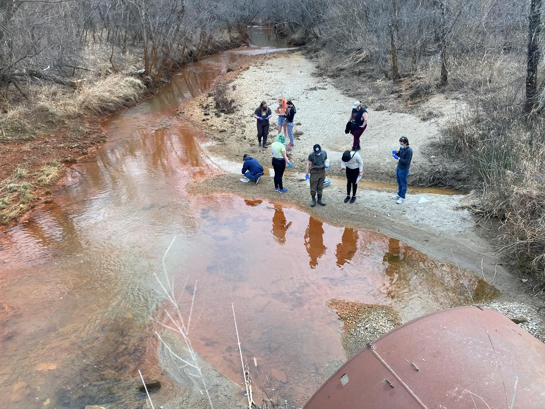
Figure 12. Students on a Tar Creek Toxic Tour get up close to examine the contaminated water of Tar Creek. Credit: Rebecca Jim.
Rebecca reflects on a toxic tour she delivered to high school students years ago and how, since then, so much has remained the same. She shares that while standing with Miami High School students on that bridge, all looking down at that water, she asked Ryan Lowell, a sophomore at the time, what he saw. He didn’t even pause. He just said he saw, “An eternal flow of evil.” Well, that about summed it up for the day, for sure (Jim & Scott, Reference Jim and Scott2007) (Figure 13).

Figure 13. Two participants on a tour observe Tar Creek from the bridge. Credit: Rebecca Jim.
Departing from the Tar Creek Superfund Site epicentre and following Tar Creek’s rusty red ribbon south through the town of Miami, visitors soon see that the heavy metal-laced waters of Tar Creek merge into the Neosho River. From this point of the tour onwards, visitors observe what Earl terms the myriad “Downstream Impacts” of the Tar Creek site. As the Neosho River winds southward through Ottawa Tribal lands, it soon merges with Spring River, the river visitors saw first on the tour that was connected with the Quapaw Tribe’s traumatic forced removal to Indian Territory. Once at the Twin Bridges area, where the Neosho and Spring Rivers join, visitors have now entered the lands and waters of the Wyandotte Nation (Figure 14).

Figure 14. The Twin Bridges area at the confluence of the Spring and Neosho Rivers. Credit: Bobbie Chew Bigby.
This Twin Bridges area is extremely significant because it is the confluence of the contaminants being brought in from the Neosho and Spring Rivers which both drain the Tri-State Mining District and the four Superfund Sites found within them. This area’s significance is further magnified given that these rivers flow into Grand Lake, one of Oklahoma’s largest lakes, a drinking water source and top recreation and tourism attraction. As Earl also points out, in recent years, unprecedented flooding has exacerbated the spread and contamination of the entire area, with high water levels in Grand Lake leaving nowhere for excess flood waters to go except to back up into the Neosho and Spring Rivers, as well as Tar Creek and the town of Miami.
Connecting to plant and animal relatives
Moving southward towards Grand Lake, visitors pass from the Wyandotte Nation into the reservation lands of the Seneca-Cayuga Nation. Many shallow areas around Twin Bridges and the mouth of the Grand Lake are favoured areas for harvesting wild plants, berries, nuts and other foods, such as fish and shellfish (Figure 15).

Figure 15. Signs marking the start of Wyandotte Nation boundaries and where Seneca-Cayuga Nation boundaries end. Credit: Bobbie Chew Bigby.
Earl shares that according to studies done by Wyandotte and Seneca-Cayuga Tribes, in addition to scholars such as Garvin et al. (Reference Garvin, Bridge and Garvin2018), the plants harvested in this area have been found to have high levels of metals due to downstream exposure from Tar Creek. Because of this, numerous traditional food favourites for tribal residents living in the area are not safe for consumption or should be under certain levels of consumption restrictions. As documented by Garvin et al. (Reference Garvin, Bridge and Garvin2018), some of these traditional foods eaten by tribal members and likely impacted can include (Figure 16):


Figure 16. The shallow area of Sycamore Creek near Grand Lake. Above in the tree is a bald eagle surveying the waterscape. Credit: Bobbie Chew Bigby.
These shallow areas near the mouth of Grand Lake are not only areas normally enjoyed by plant relatives and for harvesting activities. As visitors stop at nearby Sycamore Creek and look around and up, they will be seen and greeted by animal relatives as well. One’s patience and silence are rewarded by a glimpse of a bald eagle in the tree. Slightly further south, closer to the ceremonial grounds of the Seneca-Cayuga Tribe, is a herd of buffalo owned by the tribe. The stewardship of bison has been an extremely important activity for Tribal Nations across Oklahoma and the nation, as the buffalo is an animal of great spiritual significance and one of the most important traditional food sources that was nearly wiped out during Anglo-American settler expansion (Figures 17 and 18).

Figure 17. The bison herd raised by the Seneca-Cayuga Tribal Nation. Credit: Bobbie Chew Bigby.

Figure 18. A man gazes down on Grand Lake at the end of a toxic tour. Credit: Bobbie Chew Bigby.
These glimpses of animal and plant relatives that all humans — and not just tribal members — rely on for food, nourishment and the continuation of life help to connect the broader circle of interrelation as this tour of toxins and downstream impacts reaches its ending point of Grand Lake. Turning south where the water joins to become Grand Lake, a lake created artificially in the 1940s by the Army Corps of Engineers, this body of water absorbs all of the actions and inactions of the other bodies that flow into it — whether it is heavy metals, arsenic-containing sediments from upstream poultry facilities or an excess of phosphorous and nitrogen nutrients that contributes to regular algae blooms. While Grand Lake does border Seneca-Cayuga Tribal lands, the majority of the lake sits within the Cherokee Nation. Visitors can see that just as this body of water is fed and influenced by all of the factors witnessed along the tour, all elements in the tour are connected, from the aquatic life, winged bird relatives and plant kin that share the same assaulted lands, waters and airs we humans do, even if only for a brief visit. The expansiveness of the water at Grand Lake is a fitting ending point for this tour of connections, bringing an awareness to visitors not only of the relationships and responsibilities that we all have to places but that for tribal peoples, these relationships have been a part of life since time immemorial.
Weaving Together the Threads of (Re)Connection
Beginning from the foundation provided by some of the stories, images and reflections from toxic tours over the years that have been shared, strong resonances between the stories and the key themes from the literature analysis begin to emerge. Ultimately, these overlaps underscore the multifaceted and meaningful ways in which Indigenous-led toxic tours hold potential for forging connections and reconnections between people, place and all living creation.
At the most fundamental level, the co-authors reflect on their experiences delivering these toxic tours as opportunities for tourism to be a platform for education on multiple levels. Whether it is explaining the chemical reactions and fish kill-offs that happen as a result of heavy metal pollution in the waterways, recounting the traumatic histories of Tribal Nations being forcibly removed to new homelands or informing visitors about the wealth of foods that have traditionally been found and harvested in these places, these toxic tours make an undeniable link to education, storytelling and sharing of knowledge first and foremost. Viewed from this light, these tour experiences are not just ordinary examples of the unique cultural engagements offered through Indigenous-led tours, as increasingly documented by scholars (Butler & Hinch, Reference Butler and Hinch2007; Ruhanen & Whitford, Reference Ruhanen and Whitford2019). Moreover, these toxic tours and their explicit links to education and Indigenous knowledge sharing across numerous topics help these tours to be understood more as a potential “social force,” as articulated by Higgins-Desbiolles et al. (Reference Higgins-Desbiolles, Bigby and Doering2022) that unapologetically interweaves socio-cultural, economic and political knowledge and ways of being.
Yet the connections generated through the toxic tours do not stop at the realms of “what” is being shared through education or storytelling. Additionally, these potential threads of connection are just as focused on the linkages of “who” is impacted by the educational sharing and storytelling present through the toxic tours. From a surface level, it is clear that the co-authors, as long-standing toxic tour guides, have played a role in helping visitors and local people to facilitate connections between one another. For example, with numerous tours that have been done throughout the Tar Creek Superfund Site, the tour bus driver is often a local resident who is able to interact with visitors and share stories and memories directly. Among locals who join the tour, including, in particular, the countless high school student groups that [co-author name] has led over the years, local students and residents of the community are able to connect with one another in exploring and learning the ways that their home place has been impacted. But in applying a broader, Indigenous-informed lens in understanding community as encompassing human and non-human relations as kin (LaDuke, Reference LaDuke2016; Shade, Reference Shade1994), these toxic tours are a potential first step in helping to forge connections with place and all of creation. Ultimately, from the perspective of numerous Indigenous worldviews, these non-human forces, whether they include land, water or other aspects of creation, are understood as sapient, sentient and deserving of respect and stewardship (Wright et al., Reference Wright, Suchet-Pearson, Lloyd, Burarrwanga and Burarrwanga2009; Country et al., Reference Country, Wright, Lloyd, Suchet-Pearson, Burarrwanga, Ganambarr and Tofa2017).
Approaching these Indigenous-led toxic tours as sites of education, storytelling and connecting help to underscore the importance of educational processes that are at the heart of the toxic tour experience. In valuing the educational processes inherent in the tours themselves and the ways that the tours are built and centred around land and water, these toxic tours can easily be understood to be congruent with the concept of “land-based pedagogies” as articulated by Corntassel and Hardbarger (Reference Corntassel and Hardbarger2019). Embracing this notion of “land-based pedagogy” as a framework for the toxic tours certainly places value on the processes that are active in the tours, including notably the processes of education and connection. Yet beyond understanding education and connections as processes only, this lens of the “land-based pedagogies” as applied to toxic tours opens up space for education and connections to be outcomes in and of themselves. As Corntassel and Hardbarger (Reference Corntassel and Hardbarger2019) emphasise, this “land-based pedagogy” can be seen as a pathway to “resurgence,” which is understood as Indigenous (re)connections with culture, country and community. In prioritising resurgence, or (re)connections, as not only the process but as the objective — particularly for Indigenous peoples who have historical ties to the places and communities described here — the potential and distinctiveness of toxic tours as important tools for reconnection and education becomes more clearly evident.
Conclusion
A horrifying reality of our human existence in the present day is the fact that one need not travel far in order to encounter, engage with and even be deeply impacted by living land and waterscapes that have been toxically assaulted. Whether places and the communities — both human and non-human alike — have been transformed and impacted as a result of extractive industries, nuclear activities, improper waste management, military activities, overuse and abuse of precious natural resources such as water, or exhibit manifestations of what is commonly termed “climate change,” these places and communities are not hard to find. Yet while this evidence of toxic assault may be commonplace, the ways to approach, understand and connect with the victims of these assaults are much fewer, far between and all too often overlooked and undervalued.
LEAD Agency’s Tar Creek and Downstream Impacts Toxic Tours are offered here as one potential pathway for understanding not only the interrelated assaults and crises all too often happening in place, community and among all of creation, or all non-human living beings. Beyond providing education about the environmental assaults and history alone, these toxic tours are proposed as an important starting point for helping to (re)connect people to the places, communities and all forms of living creation upon which human lives are built in the first place. Moreover, these toxic tours’ engagement with education and (re)connections can be understood not only as processes in and of themselves but also as overarching objectives for those people involved in and connected to the tours. By leading these toxic tours from indigenous perspectives, across Indigenous lands and waters and in relationship with human and non-human kin alike, these toxic tours can be a potential first step towards deeper relationships of respect, responsibility and stewardship.
Acknowledgement
This work is supported by a Social Sciences and Humanities Research Council (SSHRC) of Canada Insight Grant (435-2018-0616) entitled, “Unsettling Tourism: Settler Stories, Indigenous Lands, and Awakening an Ethics of Reconciliation.” Gratitude to all of the communities impacted by the Superfund Site and all of the visitors who have taken the time to participate in a LEAD Agency-run toxic tour. A big thank you is also owed to Maria de Lourdes Godínez Calderón who helped to create the map in Figure 2, based off of information contained at: https://www.odot.org/hqdiv/p-r-div/maps/shp-files/. Thanks as well to Meredith Garvin for permission to use the map in Figure 4. Much gratitude to Clifton Adcock who has been a consistent supporter of LEAD Agency’s Toxic Tour work and allowed us to use many of his fantastic images.
Financial support
This research received no specific grant from any funding agency, commercial, or not-for-profit sectors.
Competing interests
None.
Ethical standard
Nothing to note.
Author Biographies
Bobbie Chew Bigby (Cherokee Nation) is a Postdoctoral Research Fellow at the University of Waterloo (Canada) and an affiliate the Nulungu Research Institute, University of Notre Dame Australia, where she recently received her PhD. Bobbie’s research looks at the possibilities of tourism as a tool for Indigenous cultural, language and environmental resurgence. Her past research fellowships, including a Fulbright award and a Rotary Peace Fellowship, have taken her to Indigenous Australia, China, India, Cambodia and Burma for research and community-based work.
Rebecca Jim (Cherokee Nation) holds a BA in Behavioral Sciences from Southern Colorado State Colleege and an MA in Education and Counseling from Northeastern State University. She is the Co-Founder and Executive Director of LEAD Agency, a non-profit organization focused on environmental justice for northeast Oklahoma. For over three decades, Rebecca served as a counselor for Indian Education programs in Oklahoma, with the majority of her time spent specifically working with the school systems in and around the Tar Creek Superfund area. Rebecca has led numerous community-based projects in support of caring for Tar Creek and uplifting the communities that call this area home. Rebecca’s work has been recognized through numerous awards, including the Waterkeeper Alliance Terry Backer Award and the Sierra Club Carrie Dickerson Award. Rebecca proudly holds the designation of being the Tar Creekkeeper with the Waterkeeper Alliance.
Earl Hatley (Abenaki Nation) is co-founder and current Board President of LEAD Agency, a grassroots organization in northeastern Oklahoma that addresses numerous issues of environmental, social and cultural concern. LEAD Agency is a member of the Waterkeeper Alliance, and since 2003, Mr. Hatley has served as the Grand Riverkeeper, patrolling the Grand River and feeder streams of the upper Grand River watershed. Mr. Hatley is a well trained and experienced environmental organizer who utilizes his training and experience to serve as a consultant to tribal and non-tribal groups (non-profits & tribal governments). He has served as an environmental consultant to Indian Tribes and Alaska Native Villages, as well as indigenous grassroots groups around the country. Mr. Hatley’s work has included helping tribal governments to develop environmental programs, water and air quality monitoring projects, write quality control instruments, write grants, conduct culturally based risk assessments, and conduct hazardous waste site investigations. Mr. Hatley also serves as an organizing consultant to national and state-wide non-profit groups, including WMAN and the Indigenous Environmental Network. His work has been recognized both locally and nationally by receiving the Carrie Dickerson Lifetime Achievement Award, the Terry Backer Award and being named a 2013 “River Hero” by the National River Network and Waterkeeper Alliance.


 Open access