

The monsoon unfailingly regulated sea-voyages in either direction in the Far East and the warm seas, thus precipitating or interrupting international encounters between merchants.
The Indian Ocean
The Indian Ocean covers approximately 75 million square kilometers. It is bordered to the west by the African coast and Arabia, to the east by the Thai–Malay peninsula, the Indonesian coasts, and – further south – western Australia. The Asian continent runs along its northern border, with India forming a wide peninsula that divides the northern Indian Ocean into eastern and western parts (the Bay of Bengal and the Sea of India, respectively). The western part of the Indian Ocean extends along both sides of Arabia, with a narrow entrance opening onto the Persian Gulf to the north and the Red Sea to the south. South of India, the Maldive Islands are scattered north of the Equator, while the Chagos Islands lie south of the Equator. The narrow channel of the Strait of Malacca is the crossing point between the Indian Ocean and the China Sea, to the north.
Wind Patterns
Wind patterns, around the world, are determined by the existence of high-pressure zones in the Northern and Southern Hemispheres at both higher and subtropical latitudes. Between these high-pressure zones and the Equator, air flows are deflected by the Earth’s rotation (this is the Coriolis effect); it gives birth to the austral and boreal trade winds. The equatorial region is a zone of ascending movements and low pressure. These zones experience seasonal translational movements. The force of these translational movements pushes the trade winds past the Equator; then these winds change direction, toward the southeast for boreal trade winds, and toward the northeast for austral trade winds. In the Indian Ocean, these phenomena give rise to an alternating system of monsoons,Footnote 1 which imposes its laws on sailors.
In the Northern Hemisphere, during the boreal summer, Asia’s land masses warm more rapidly than the ocean, and an upward movement of air masses occurs on the continent, causing low-pressure systems over Central Asia and northern China. Both the high subtropical pressure systems of the southern Indian Ocean and the low intertropical pressure systems shift northward, and a southwest monsoon wind blows over the northern Indian Ocean. Conversely, when the boreal winter sets in, the land masses cool more rapidly than the ocean, the phenomena are reversed and now it is a northeast wind that blows over the northern Indian Ocean.
In June, the southeasterly trade winds of the Southern Hemisphere cross the Equator, subjecting all of the northern Indian Ocean to the southwest monsoon. In the east, this flow reaches Sulawesi and the China Sea as a south wind: “Ships from the southern seas came to China with the south-west wind …; the half year from May to October was the busiest time at the sea ports” (Filesi Reference Filesi1972: 15).
In October, the subtropical high-pressure area begins to shift southward. East of 80°E, the austral trade wind goes no further than the Equator; a zone of doldrums forms over insular Southeast Asia and another over the Bay of Bengal. Conversely, west of 80°E, the austral trade wind continues to cross the Equator, blowing from the southwest. It even blows from the west between the Equator and 10°N as far as the Gulf of Thailand.
In November, the northeast trade winds travel far to the south in the region of insular Southeast Asia; further west, they go no further than Sri Lanka. In East Africa, the monsoon weakens south of the Pangani River. The southeast trade winds remain in the Southern Hemisphere.
In December, a zone of strong high pressure settles over Central Asia. The boreal trade winds begin crossing the Equator, and in January the southeast trade winds take up their southernmost position. Further east, the Australian continent deflects these winds into south/southwesterly winds, that reach the Javanese coasts and islands further east. The northern Indian Ocean and the China Sea come under the influence of the northeast trade winds. These boreal trade winds blow toward the southeast (as northwest winds) beyond the Equator. The Intertropical Convergence Zone, south of the Equator, extends further south into the western part of the Indian Ocean: it reaches Madagascar, which thus receives both north and northwest winds in its north/northwestern region, while a portion of the Malagasy east coast remains under the influence of the austral trade winds. The Convergence Zone moves south into the Mozambique Channel, a low-pressure area; the Cape Delgado region and the coast north of it are hit by northeast winds.
In March, the high-pressure systems move northward. The northeasterly trade winds return, reaching only as far as Sri Lanka, Malaysia, and Kalimantan; yet, they still cross the Equator in the vicinity of Sulawesi. A southwesterly airstream blows over Oman and India, as well as over the northern part of the Gulf of Bengal. During this period, the Gulf of Bengal is divided into two zones, each subjected to contrary winds, “on both sides of a line of discontinuity running from the Palk Strait to Arakan” (Donque Reference Donque1965: 49).
In the north, the April northeasterly trade winds continue to return. Only the southern Philippines and the northeastern Kalimantan still receive northeasterly winds. In the Indian Ocean, the austral trade winds now blow beyond the Equator, becoming southwesterly winds, reaching the Gulf of Thailand. Along the southern coasts of Java and further east, the austral trade winds lose their curve and blow straight from the southeast.
In May, this trend continues. Although the austral trade winds do not yet reach the Equator in the more eastern part of the Indian Ocean, they do cross the Equator west of 90°E. A zone of equatorial calm affects Malaysia, Sumatra, Kalimantan, and the Philippines.
These winds’ direction and strength made navigation almost impossible from June to September along the west coast of India. “Most of the Indian harbors were closed at the height of the southwest monsoon. These were preferably reached from the western Indian Ocean ports during the months of August–September, when the ferocity of the monsoon winds and torrential rain would die down somewhat” (Chakravarti Reference 664Chakravarti, Parkin and Barnes2002a: 49). During the southwest monsoon, as well, it was difficult to sail or berth along the west coast of Malaysia, or on the south coast of Arabia. It was possible, however, to leave at the beginning of this monsoon, around mid-April (according to the Arab pilot Sulaymān al-Mahrī, sixteenth century; Tibbetts Reference Tibbetts1971: 372). Travel from Oman to India could be undertaken at any time during the year except between May and July. Ships from India’s west coast arrived at Aden in April. One traveled from Gujarat to Aden mainly from October to December, with the return journey between March and May. From South India, ships departed between March and June. Ships left Aden to sail to the Malabar coast from October to February, or at the end of the southwest monsoon (late August–September; see below).Footnote 2 Between June and October, one could sail back to India along a portion of the South Arabian coastline. Ibn Battūta (fourteenth century) notes that the trip from Calicut to Ẓafār (in Dhofar) lasted one month.
To sail from the west coast of India to the Bay of Bengal and Sumatra, one could leave at the start of the southwest monsoon (the “head of the wind”). “The sailing season from Gujarat toward Malāqa, Shumatra, Tanāsarī, Banjāla and all the ‘downwind’ ports,” writes Sulaymān al-Mahrī, “[runs] from the 120th to the 160th day from the Nairūz (beginning of the solar year), but the best choice is on the 140th day [this means around April 10, the beginning of the Nairūz at the time of Sulaymān al-Mahrī being around November 21Footnote 3].Footnote 4 The sailing season from Manībār [Malabar] toward Malāqa, Shumatra, Tanāsarī, Martaban, Banjāla and all their ports: the 160th day from the Nairūz.” One also sailed from the west to the orient at the end of the southwest monsoon: “The sailing season from Aden to Manībār, Konkan and Gujerat: on the 280th day from the Nairûz [around August 28].Footnote 5 … The sailing season from Gujerat toward Malāqa, Shumatra, Tanāsarī, Banjāla and all the ‘downwind’ ports: on the first 300th … The season for Manībār toward Malāqa, Shumatra, Tanāsarī and all their ports: on the 310th day” (C. Jouannès, p.c.). From Aden to Malacca, according to al-Mahrī, one departed around August 15. For the return journey, from Malacca to Aden, one left between December 28 and February 16. From China, ships left between the end of November and March 1; a November departure made it possible for ships to reach Malacca and to cross the Bay of Bengal in a single journey (Tibbetts Reference Tibbetts1971).
As for East Africa, in order to reach its coasts, the Omani pilot Ibn Mājid (fifteenth century) recommended a departure from Aden between the 320th and the 330th day of the year [from the Nairūz] [October 8 to 18, when the author wrote his book; see below], from Hormuz around the 70th day [January 31], from India up to the 80th [February 10], and from Sumatra from the 60th day [January 21] (Tibbetts Reference Tibbetts1971: 234, 360ff., 378; Sheriff Reference Sheriff, Parkin and Barnes2002: 213). Fortunately for trade, ships arrived on the East African coast when agricultural activities were minimal. The return from the African coast toward Arabia or India could be made between April and May, before the full rise of the monsoon or at the end of the season, in August. During the thirteenth century, Marco Polo describes sailing from the coast of Malabar to Zanzibar in twenty days, but the return journey lasted three months, due to contrary currents.
On the East African coast, once past Cape Delgado, one sailed in a southerly direction at the beginning of the austral summer. Ibn Mājid writes: “The best season from Kilwa to Sufāla is from the first [day] of the Nairūz to the 50th day [that is to say, from November 14 to January 2], but if you set out from Sufāla, you should do it on the 170th day [around May 11], this is the best season of all. Before that date, you encounter the disastrous Kūs wind [southwest monsoon], which is too weak, and later, it becomes too strong in these headlands and you should sail eastward to the open sea [to avoid being driven ashore].” “The sailing season from as-Sawāḥil to al-Qumr [Madagascar] and its isles, and then to as-Sufāl extends from the first [day] of the Nairūz to the 70th. For the pilot of Kilwa the season is on the 90th day …The pilots of al-Qumr have two seasons for as-Sawāḥil” (Khoury Reference 700Khoury1982: 270, 281; Jouannès Reference Jouannès2001: 79, 95). To sail from Sofala to Kilwa, one departed between April 17 and May 17.
Moreover, some areas, such as the Red Sea, have special wind conditions. From June to September, winds and currents facilitate journeys to the entrance of this sea, with northerly winds in most of the Red Sea, and a current which sets to the south-southeast; the winds and currents are partially reversed between October and May, with the most favorable season for sailing back to the north being January and February (Meeks Reference Meeks2002: 324; Pearson Reference Pearson2003: 20). The situation is complex, however, with “winds north-northwest in the northern part of the Red Sea and south–southeast in its southern part. Between these two regions, there is a zone of calms or light and variable winds between 18° and 20° North. The current between November and April sets north-northwest in nearly all of the Red Sea. Travel to the north of the Red Sea, therefore, was not easy, and maritime traffic most often stopped in the zone of calms” (C. Jouannès, p.c.). This phenomenon partly explains the development of ports such as Berenice, ‘Aydhab and Jeddah (see Facey Reference Facey, Lunde and Porter2004).
It was of vital importance for captains to know the system of monsoons, which dictated the movements of ships. The period when the winds became reversed was a particularly dangerous one. Ibn Mājid writes: “He who leaves India [for Arabia] on the 100th day [after the Nairūz, which means March 2 when the author writes his book] is a wise man; he who leaves on the 110th day will be all right; but he who leaves on the 120th day is stretching the bounds of possibility and he who leaves on the 130th day is inexperienced and an ignorant gambler” (Tibbetts Reference Tibbetts1971: 231).
The Currents
Ship captains also had to take account of the currents, which depend upon planetary mechanisms, and are affected by changes in temperature and winds.
During the austral summer, between 20°S and 10°S, a South Equatorial Current crosses the Indian Ocean from east to west, at a moderate speed (25 to 30 km per day). This current hits Madagascar at the level of Toamasina (Tamatave), and then divides into two branches. The southern branch joins currents running from South Africa to Australia, south of Madagascar; part of this branch, however, flows around Cape Sainte-Marie (at the southern tip of Madagascar) and runs up the Mozambique Channel. The wider northern branch flows around northern Madagascar, hitting the African coast in the vicinity of Cape Delgado, where a new division occurs: a northern current flows along the Tanzanian coasts, while another current makes its way south into the Mozambique Channel. Two currents of opposite directions and uneven forces thus ride this Channel: a south–north current flows along the west coast of Madagascar, and a north–south current flows along the African coast. Their encounter gives rise to numerous crosscurrents.
During the same period, in the northern Indian Ocean, the northeast monsoon favors a North Equatorial Current, whereas south of the Equator an Equatorial Countercurrent develops, along the 7° South latitude. When it arrives near the African coast, the North Equatorial Current curves southward as a result of the northeast monsoon. Further north, in the Sea of India and even more so in the Bay of Bengal, two systems of currents arise, turning clockwise. In the China Sea, a current flows along the coasts of China and Vietnam; then it arcs southward, reaches southern Sumatra and northern Java and enters the Pacific to feed the Pacific Equatorial Countercurrent.
During the southern winter, the southern currents of the Indian Ocean tend to reach southern Australia directly, and the anticyclonic movement of water is therefore less pronounced. It is during this period, however, that the South Equatorial Current reaches its highest speed, thanks to the southeast trade winds, and due to currents from the Pacific, north of Australia. This gives birth to a more powerful current than before in the Mozambique Channel, and to a strong south–north current along the Kenyan and Somali coasts (the Somali Current), favored by the southwest monsoon.
In the Northern Hemisphere, during the summer, the southwest monsoon favors a west–east monsoon current north of the Equator, a southwest–northeast current along the South Arabian coast, and a north–south current along India’s west coast. The Equatorial Countercurrent completely disappears at this time. In the Gulf of Bengal, the monsoon current sweeps toward the northeast, and northeast–southwest countercurrents appear along the Coromandel coast. In the Gulf of Thailand, west–east currents dominate and in the China Sea we find southwest–northeast currents. A southeast–northwest current flows from southern Sulawesi to southeastern Sumatra, then curves and flows along the east coast of the Thai–Malay peninsula and then toward the northeast along the Indochinese coast.
As for the Red Sea, a dominant current flows from Egypt to Yemen during the summer, whereas during the cooler season the situation is more complex, with south–north currents along the Yemeni and Arab coasts, but north–south currents in the Gulf of Aqaba and along the Sudanese coast. Moreover, many reefs dot this sea, making navigation unsafe (see Pearson Reference Pearson2003: 17).
In the Persian Gulf, the dominant currents beyond Hormuz are northwest–southeast during the summer, and are the reverse during the cooler season.
These geographical data have imposed their laws on sailors. They have determined the routes followed by ships, and the seasons for navigation. I will return to this point when I speak of the Austronesians’ trips to the west.
Madagascar
The island of Madagascar extends from 12°S to 25°S; it is 1580 km long, and approximately 550 km wide at its median part. A central plateau with an average altitude of between 800 and 1400 m descends to the eastern coast through two series of cliffs. To the west, the elevation descends more gently via successive plateaus. Several mountains exceed 2000 m in height: Tsaratanàna in the north, Ankaratra in the center, and Andringitra in the central southeast.
Wind patterns determine two large climatic areas: a windward region, hot and humid, and a leeward region, hot and drier. In the austral winter, Madagascar is hit by a dominant flow of eastern trade winds, which tend to take a northeast–southwest direction in the south of the island (Fort-Dauphin), and a southeast–northwest direction in the northeast (Antsiranana). A diffluence occurs off the east coast near the latitude of Vatomandry. Some of the trade winds cross the eastern cliffs, and then take a southwesterly direction toward the southern part of the island.
During the austral summer, in the western Indian Ocean, the Intertropical Convergence Zone crosses the Equator and reaches Madagascar. A low-pressure area forms in the Mozambique Channel. Northern Madagascar is hit by north monsoon winds. Further south, along the west coast, the winds veer westward, under the effect of the Coriolis force. Less active than during the cooler season, the austral trade wind still manages to reach the east coast. Along the coasts, the days are punctuated by alternating sea and land breezes, which are more pronounced on the west coast than on the east coast, and are also stronger in the summer than they are in the cooler season.
The island is divided into four large phytogeographical zones. The east coast, humid, tropical, fringed with lagoons and dunes, was in the past covered with forest, which has largely disappeared through human activity, except in the northeast and in some parts of the highest cliffs separating the coast and the Highlands. These have given way to zones of pseudo-steppes, with patches of secondary forest where the Traveler’s Palm dominates. A series of rivers, necessarily short, range along the coast; the main rivers are the Maningory, Mangoro, Sakaleoña, Mananjary, Faraoñy, Matatàña, Manampatraña, and the Mananara. The extreme northwest (between Nosy Be and the coast south of Antsiranana) also enjoys a humid tropical climate. Along the entire eastern coast north of Manakara, precipitation exceeds 2000 mm annually.
The Highlands, in the past covered by a forest–savanna mosaic, have since been deforested and eroded by human activity (nowadays only residual forests subsist at sacred sites). The Highlands are composed of landscapes of red hills and wetlands, most now converted into irrigated ricefields. Its average annual rainfall varies from 1200 to 1600 mm.
Some large rivers flow down from the Highlands into the western savannas: these are the Sofia, Mahajamba, and Betsibòka rivers, in the northwest, and Manambao, Manambolo, Tsiribihina, and Mangoky rivers, on the west coast. In the latter region, the year is marked by two clearly defined seasons: a very dry “winter” and a humid summer. Annual precipitation is under 1000 mm near the coasts (except in the northwest, which is progressively wetter as one travels further north). The only remaining forest consists of gallery forest along rivers. Several large bays indent the northwest coast, offering harbors for ships.
The south and the southwest of the island experience a semi-arid climate, with sharp irregularities in precipitation averaging from 250 to 500 mm per year. The dry forests of the southwest have also largely been cleared. One finds only one large river in this region, the Oñilahy; it flows to the sea in the Bay of Saint-Augustine, south of Tulear.
The arrival of the first migrants brought enormous changes in the ecosystems of the island, particularly following the introduction of domesticated animals, sheep, goats, and cattle, leading to the progressive disappearance of various wild animals: giant tortoises, dwarf hippos, large lemurs, and giant ratites (Mullerornis and Aepyornis).
Navigation of the Indian Ocean
I did not leave one star in the sky that I did not use to guide me.
In order to steer his ship across the ocean, an “ideal pilot” had to know the winds, the currents, and their changes during the year, as well as the lunar mansions, or “the course of the celestial luminaries”; he had to be able to recognize signs and landmarks, the configuration of the coastline, with mountains, capes, islands and their rocks, the color of the water, the birds, the fishes and the seaweeds (Tibbetts Reference Tibbetts1971: 1–2; Sheriff Reference Sheriff, Parkin and Barnes2002: 210, 214).
Very early on, sailors learned how to orient themselves by observing the stars, and to assess the latitude of a given place. They invented instruments to measure the positions of certain stars.
Among the Arabs, “latitude” was [notably] measured by gauging the height of the Polaris star (Jāh)Footnote 6 when the latter was at the lowest point of its trajectory. When a place was situated at Jāh 12, this meant that the Polaris was observed 12 fingers’ width above the horizon when this star was ‘in its house’, in the lowest part of its diurnal rotation … Among the Arab pilots of the Indian Ocean, change in latitude had been fixed at one finger [Arabic iṣba‘], which means 1°45Footnote 7 … The tirfā represented the distance one had to sail in order to observe a variation in latitude of one finger … This notion of tirfā … was known to the three schools of deep-sea pilots who, according to Sulaymān al-Mahrī, sailed across the Indian Ocean: 1. the Arabs, 2. The Indians of Gujarat and Konkan, and 3. the Cholas of the Coromandel coast.
When the Muslim world acquired knowledge of the compass from the Chinese, the compass became linked to the rising and setting of certain stars, during the twelfth or thirteenth century (Tibbetts Reference Tibbetts1971: 3, 290, 295). The Turkish geographer Sidi Ali Çelebi, in his Mohit (1554), which is partly based on the works of the mu’allim (pilots and scholars) Ibn Mājid (fifteenth–sixteenth century) and Sulaymān al-Mahrī (sixteenth century), describes for the first time a measuring instrument that must have been in common use on ships plying the Indian Ocean. This instrument consisted
of a number of oblong pieces of wood [loḥ, ‘tablet’] of different sizes with a string or different strings passing through their centers. To measure the height of Polaris in the northern latitudes, or one of the Bears in the southern latitudes, the string was held between the teeth with the wood at a distance from the eye such that while the lower edge [of the wood] was in line with the horizon, [its] upper edge just touched the star. Latitude was calculated in terms of numbers of finger widths (isbas) above the horizon.
“Sidi Çelebi had a system of nine tablets each with a string through it, or with one string through them all. The nine tablets each had a different width corresponding to different angular altitudes on the horizon” (Tibbetts Reference Tibbetts1971: 316). According to Sidi Çelebi, this was the instrument used by the ancients, but in his own time, he describes “a graduated rod with a small wooden rectangle sliding on it” (see Tibbetts Reference Tibbetts1971: 316): here we recognize the instrument that the southern Europeans called ballisti or Jacob’s staff, and which the Portuguese called balestrilha, deriving from the Persian bālā, “height” and astar, “star” (the instrument’s origin may go back to Antiquity: during the early third century bce, the Greek philosophers Timocharis and Aristyllus probably used a Jacob’s staff to assess the declinations of some stars). “The kamal was improved upon by replacing the different pieces of wood by a single tablet, and the single string was calibrated by a number of knots indicating different latitudes” (Sheriff Reference Sheriff, Parkin and Barnes2002: 217; 2010: 123) or marking regular intervals of isba: here one recognizes the kamal described in 1836 by Princep from data provided by a sailor from the Maldives. Note that Ibn Mājid does not use the term kamal, and he does not describe the precise way in which the instrument was employed during his time. He mentions only the use by pilots of the Indian Ocean of different “pieces of wood” khashaba for measuring stellar altitude (qiyās) (the word khashaba is sometimes rendered as khāḍaba or ḥataba) (Tibbetts Reference Tibbetts1971: 317). “Ibn Majid takes his stellar altitude measurements using 24 pieces of wood” (Khoury Reference Khoury1985–1986: 215). In his “poem with a rhyme in mim” “on the six main abdāl methods of using Sharatān (alpha Arietis) and ‘Anaq (Urs. Maj.)” (Tibbets Reference Tibbetts1971: 19), Ibn Mājid writes: “My instrument of measure (qiyāsī) [is composed] of 20 pieces of wood and four more in total and necessarily [verse 19]. When stars appear, I shoot arrows to them that meet their goals [verse 20], they do not miss their target thanks to their mark and to the rope whose ends are between the palm [of my hand] and my wrist [verse 21]. [These pieces of wood are] angels who do not deceive [verse 22]” (G. Ducatez, p.c.). “The khashaba boards,” confirms Jouannès, “were tablets; their top edges were placed in contact with the star while the lower edges touched the horizon at sea. Whereas for the kamal, the variable element was the distance from the board to the eye of the observer (measured by knots on a thread attached to the center of the board); in the other case, arm length was constant. It was therefore the dimension of the board that had to be variable, whence the necessity of having a number of boards” (12, or even 24) (Jouannès, Reference Jouannèsforthcoming). These tablets did not allow sailors to observe stars which were too high in the sky. “Measurements practiced by seamen,” writes Sulaymān al-Mahrī, “go from one to twelve fingers [from 1°8 to 21°].” “Fatimi shows that a similar instrument … may have been in use since the ninth century” (Sheriff Reference Sheriff, Parkin and Barnes2002: 216). Measurements (qiyās) did not consist only in evaluating the height of Polaris or the Southern Cross: Ibn Mājid gives as many as seventy types of measurement in the Fawā’id (Tibbetts Reference Tibbetts1971: 325ff.).

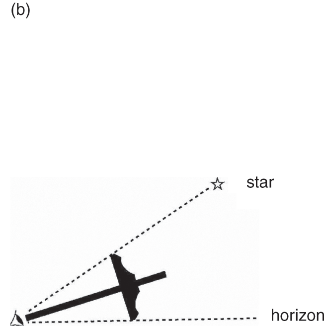
(b) Cross-staff (Jacob’s staff). This type of instrument was used in the Greek world during the third century bce; its use may be older in western Asia.
A Chinese sailor called Ma-Huai-te, who accompanied Zheng He’s expeditions during the early fifteenth century, developed an instrument that probably derived from the cross-staff of the Indian Ocean (Fatimi Reference Fatimi, Ray and Salles1996: 289; Sheriff Reference Sheriff, Parkin and Barnes2002: 217). This Chinese reinvention provides a good example of the knowledge exchanges on the scale of the world-system, exchanges that had in fact been occurring since the dawn of this system. The Gujarati pilot who guided Vasco de Gama from East Africa to India used a Jacob’s staff, which Vasco de Gama took back to Portugal in 1499, to be tested by Portuguese sailors (“The Portuguese modified the instrument to read degrees directly instead of the standard finger widths of the Arabs”) (Sheriff Reference Sheriff, Parkin and Barnes2002: 219).
It was thus possible to determine the vessel’s latitude, but
Indian Ocean mariners were not able to calculate longitude prior to the introduction of the sextant … [They] sailed first to the latitude of the destination, and then changing course in mid-ocean [they sailed] due east or west until landfall was made … Speed of the dhow was calculated by dropping a floating object at the stem of the dhow, and calculating the time it took to reach the stern. East-west measurement of distance was calculated in terms of the zam (watch), a standard three hours of sailing [or one-eighth of a degree].
The solar calendar of Persian origin was widely used by sailors in the western Indian Ocean, and probably since the Sassanid period.Footnote 9 Persia’s preeminence during the first centuries of Islam is apparent in boating terminology.Footnote 10 This is only one element among others in the elaboration of a culture shared by sailors in the Indian Ocean and the China Sea. Even prior to the Christian era, Arabs, Indians, Austronesians, the inhabitants of southern China, and later the Chinese themselves (from the Han period) were all actively exchanging knowledge and evolving methods of navigational technology. The cosmopolitanism of the ports of the ocean corresponded to that of the crews in the transnational networks.
Exchanges in the Indian Ocean varied according to developments in naval technology. Improvements in the field of shipbuilding allowed ships to travel faster and carry progressively greater loads. We shall see, moreover, that the monsoon system has not remained static over the centuries. In the northern Indian ocean, periods of weak summer monsoons have accompanied phases of low solar activity; conversely, more intense solar activity seems to be correlated with strong summer monsoons. These phenomena are subject to a number of cyclicities.


