

Floods would not be a hazard were not man tempted to occupy the floodplain.
Cartographers have always struggled to represent rivers. To render nature legible, they are forced to freeze water in time, turning complex evolving systems into fixed blue lines, which cut simplistic linear trajectories from origins to destinations. If it were possible to view history on a time-lapse – condensing millennia to minutes – we would see rivers writhing across their plains like living entities; expanding and contracting with the pulse of the seasons, rising and falling with long- and short-term climatic changes. This chapter reconstructs the history of one such river – the Yangzi – a watercourse that shaped and was shaped by the people who made their homes on its plains. We focus, in particular, on Hubei, a province in the middle reaches of the Yangzi that is dominated by rivers, lakes and wetlands, and, as a result, is naturally highly flood-prone. Humans did not always see this as a problem, as abundant water could be a blessing as well as a curse. It took a particular mode of human interaction with the environment to transform natural floods into humanitarian disasters. This chapter describes the history of this transformation, tracing the long-term evolution of the modern disaster regime from which the 1931 flood emerged.
The epigraph from the renowned geographer of disasters Gilbert White encapsulates much of what is argued in this chapter. Flooding, as a human hazard rather than a hydrological process, is never entirely natural. Disastrous inundations occur when people interact with water in particular ways. Succinct as it may be, however, White's assessment does not do justice to the complexity of environmental history. For floodplains do not remain static; their contours change continuously under the influence of environmental and anthropogenic processes. Hence, people may settle in a dry area that may become a floodplain over time. Furthermore, living on a floodplain does not necessarily put one at risk of disaster. Inundation becomes truly disastrous only under particular configurations of subsistence and settlement. The population of Hubei constructed a lifestyle that depended on flood-supressing technologies. When these failed, they faced calamitous consequences. The fact that such hydraulic strategies have become ubiquitous in the modern world should not be taken as evidence that they were the historical norm. People can learn to accommodate and even benefit from regular infusions of water, while avoiding larger floods by tactical evacuation or by using technologies to float on water.Footnote 2 We might augment White's conclusions, therefore, with the observation that floods would not be hazards if humans could adapt themselves to the environment rather than adapting the environment to themselves.
The story of how floods became disasters in Hubei can be read as part of the broader history of the human transformation of the hydrosphere. Throughout the world people have drained wetlands, channelised rivers, and denuded forested catchments. Much of Hubei was once a vast wetland, which fostered a highly biodiverse ecosystem. As wetland became farmland, the environment was deprived of complex biogeochemical systems. The ecologists William Mitsch and James Gosselink have described wetlands as the ‘kidneys of the landscape’ – they cleanse water, recharge aquifers and absorb flood pulses.Footnote 3 Losing these kidneys is a serious blow, not just to the environment but also to human beings. In detailing the evolution of flooding, this chapter also describes the decline of biodiversity and the loss of the wetland culture practised by a people who found ways to live between water and land. Yet this should not be read solely as a declensionist narrative.Footnote 4 Wetland species and wetland culture were never erased entirely. Both survived, albeit in muted forms, offering vital resources for flooded communities. Unfortunately, residents of Hubei had to cope not only with the primary hazard of inundation but also with flood-induced famines and epidemics. By the twentieth century, these secondary risks killed far more people than the physical impact of inundation itself. In detailing the long-term evolution of the modern disaster regime, this chapter provides an environmental history not only of flooding, but also of the hunger and disease that came in the wake of water.
Natural Floods
Forty-five million years ago, the Indian and Eurasian tectonic plates collided, lifting the Himalayas and creating the Tibetan–Qinghai Plateau.Footnote 5 As water drained off these new highlands over millions of years, it etched the basins of many of the greatest rivers in Asia.Footnote 6 Some flowed south to create the Indus and Brahmaputra, which would shape the lives of millions of South Asians. Some flowed southeast to form the Mekong and Salween, which would nurture the forests and farms of mainland Southeast Asians. Some flowed east, creating two major rivers. The first of these was the Yellow River, an unpredictable watercourse that cut a meandering path through a loess soil landscape. The second would become the greatest river in Asia – and the third longest in the world. Known in the English-speaking world as the Yangzi – a name that locals use to refer to a small eastern stretch of its course – to Chinese people this is the Long River or Changjiang 长江.Footnote 7
The valley carved out by the Yangzi would eventually drain over a million square kilometres.Footnote 8 As water cut through the surface of the land it met ancient seams of granite and quartzite, which formed ridges that divided the valley into distinct basins.Footnote 9 These basins came to define the three major reaches of the river. The upper Yangzi flows down from Tibet, across Yunnan, and then through the distinctive red sandstone of the Sichuan basin. As it funnels through a mountainous area in western Hubei, it carves the scenic yet treacherous rapids of the Three Gorges. Beyond this point the river is known as the middle Yangzi, a broad watercourse distinct in character from the fast-flowing upper reaches. In its journey across the alluvial and lacustrine plains of Hunan and Hubei, the middle Yangzi drinks up vast quantities of water, increasing in size dramatically before narrowing to cut between the highland ridges that form the border with Jiangxi.Footnote 10 Having met Poyang Lake, the river continues to Anhui and Jiangsu, where it becomes the lower Yangzi. It splits into multiple streams, forming a delta, and finally, having travelled 6,380 kilometres, completes its journey by flowing into the East China Sea.
Long before humans set foot in Hubei, the region was already experiencing natural floods. These occurred when the stream flow of rivers exceeded the discharge capacity of their channels.Footnote 11 Much of Hubei is located within a geological depression tapering into a mountainous bottleneck in the east. Water accumulates easily yet is slow to discharge.Footnote 12 In the east of the province, the Yangzi meets the Han River 汉江, its largest single tributary. The plains formed by these two great watercourses are crisscrossed with smaller rivers and dotted with lakes and marshes. These once formed part of a vast network of wetlands, more extensive than any others found in the temperate world, which stretched continuously along plains of the middle and lower Yangzi.Footnote 13 The stream flow of rivers in Hubei varies in accordance with the cycle of seasons. In average years, the basin experiences three surges of high water, in the spring, summer and autumn.Footnote 14 The water table is at its lowest in the winter. Relatively little rain falls between October and May, and precipitation in highland catchments gathers as snow. These frozen reservoirs melt in the spring, infusing rivers with large volumes of water at the same time that the region experiences the first of its three annual waves of precipitation.Footnote 15 In the summer, cold fronts collide with humid air masses from the subtropics, causing the heaviest rainfall.Footnote 16 These summer deluges tend to be the trigger for major flooding.
The middle Yangzi is the intermediary zone between the hammer and anvil of two monsoon systems. The East Asian monsoon determines the level of precipitation in the basin itself. The South Asian monsoon affects rain- and snowfall in the upper Yangzi, thereby helping to determine how much water is discharged downstream.Footnote 17 Both monsoon systems are subject to external climatic influences. The sulphur dioxide emitted during volcanic eruptions affects atmospheric temperatures and may have an influence on the stream flow of the Yangzi, though the exact nature of volcanic–monsoon linkages remains unclear.Footnote 18 Fluctuating sea surface temperatures in the Pacific Ocean – the infamous El Niño Southern Oscillation (ENSO) – have a more discernible influence. There is some evidence to suggest that large floods, including those of 1954 and 1998, are caused by El Niño and La Niña events. Caution should be exercised before drawing direct causal links, however. Unlike the well-established teleconnection between El Niño and rainfall patterns on the North China Plain, the exact role that ENSO plays in Yangzi flooding remains a matter of debate.Footnote 19
The annual rise and fall of rivers and lakes helped to forge a highly diverse ecosystem in Hubei. As with many river systems, the flood pulse came to play a vital role in the biogeochemical cycle, transferring valuable nutrients between aquatic, terrestrial and wetland areas. Fast flowing water stripped millions of organisms from riverbeds and floodplains, creating empty patches that were colonised by a wide range of biota.Footnote 20 Floods also helped to distribute seeds and fruit, increasing the range of local plants, and purged invasive species that may otherwise have become overly dominant. Far from being simply destructive, regular flood pulsing was, as the ecologist Seth Reice has put it, ‘an essential recharge mechanism’, bringing life to both rivers and floodplains.Footnote 21 The biodiversity created by natural flooding would have been extremely attractive to early humans, who could exploit a rich mosaic of aquatic, riparian and terrestrial habitats. From the outset, then, people did not settle Hubei in spite of floods, but because of them.
Settling Floodplains
For much of human history Hubei looked quite different from the way it does today. At the beginning of the Holocene, around 11,500 years ago, the Yangzi was a branched river, flowing in three distinct streams that were prone to shifting course and wandering across the basin. Most of central and eastern Hubei was home to a vast wetland known as the Yunmeng Marsh 云梦泽.Footnote 22 Though hard to imagine today, the zoologist Samuel Turvey suggests that the middle Yangzi was then the ‘Amazon of the East’, home to a vast assemblage of flora and fauna.Footnote 23 Rivers and lakes teemed with fish, turtles, alligators, finless porpoises and Yangzi river dolphins. The plains were covered with thick forests of coniferous and deciduous trees, home to pandas, elephants, giant tapirs, gibbons and rhinoceroses. The wetlands supported abundant waterfowl and wading birds, including five species of crane that nested in thick reed beds.Footnote 24 This natural abundance was attractive to hunter-gatherers, and later helped to support early experiments in plant and animal domestication.Footnote 25
Early settlers were particularly drawn to a form of semi-aquatic grass known as wild rice. Although there remains some debate about when and where this species was first domesticated, we know that communities in the middle Yangzi region were cultivating it deliberately, rather than simply foraging for it, by at least as early as 7500–6000 bce.Footnote 26 Rice became central to the economy and society of this region not least because it proved to be the perfect biological technology to colonise wetlands. Unlike dry land crops, which require aerated soil, rice can grow under water, thanks to its specialised aerenchyma tissue that diffuses oxygen down its stems to its roots.Footnote 27 This water resistance may help to explain the rapid growth of rice cultivation between 6000 and 3000 bce, which was a particularly warm and therefore wet climatic epoch.Footnote 28 Flood pulses were the lifeblood of rice agriculture, bathing the land in a nutrient-rich cocktail of minerals and water, leaving fertile deposits of nitrogen and phosphorus in their wake.Footnote 29 This natural redistribution of biomass meant that rice farmers had to introduce far less fertiliser than those cultivating dry land.Footnote 30
Rice domestication allowed farmers to maximise yields, yet it also created a nutritional system that was dependent on predictable patterns of meteorology. Wild rice (Oryza rufipogon) articulates its seeds individually, maximising the chance of sustained reproduction in a wetland environment subject to fluctuating water levels. By encouraging the seeds of domesticated rice (Oryza sativa) to ripen synchronously, people could harvest the grain much more easily, yet this process made the plant less flood resistant.Footnote 31 Should the rains prove overabundant, farmers would lose a whole generation of crops and a source of nutrition that represented significant inputs of labour and time. In this sense, the subsistence crises that would, in later eras, help to make floods substantially more dangerous, were, as David Christian has argued, ‘a paradoxical by-product of the agricultural revolution’.Footnote 32 The catastrophic famines of the modern era had deep roots in an ancient interaction between people and plants.
Just as humans changed rice, rice also changed humans. To furnish their chosen plant with a habitat conducive to successful propagation, people transformed their patterns of settlement. In doing so, they fundamentally altered their relationship with rivers. Early rice farmers practised flood-recession agriculture, planting their crops on mud banks after the annual inundation had abated. Over time this minimally invasive form of cultivation was augmented with a form of landscape modification, in which farmers transplanted rice shoots onto bunded terraces known as paddy fields. By 2500 bce these structures were beginning to spread throughout the Yangzi Valley.Footnote 33 Paddy fields were essentially artificial wetlands, allowing farmers to imitate the flood pulse while guaranteeing its regularity. They formed part of a suite of technologies that would eventually spread across a vast rice belt in Asia, which continues to feed much of the population of the world today. By the early modern era, paddy fields were helping colonists to transform wetlands as far afield as the lower Mississippi. Before commercial crops such as tobacco and cotton lured plantation owners to drain the land in this region, the lower Mississippi was known as the China of America.Footnote 34
The rise of sedentary agriculture marked a key conceptual shift in the relationship between humans and water. Hunter-gatherers and flood-recession agriculturalists could evacuate with relative ease when threatened by floods. This is also a strategy favoured by many wetland animals, which retreat from water to shelter in areas known as refugia. Those who had modified the landscape risked losing significant investments of labour and time if they simply abandoned their homes. Being stuck in the path of a flood was one of the many consequences of what David Christian has described as ‘the trap of sedentism’.Footnote 35 Later, growing populations and changing modes of social organisation made it virtually impossible for people to return to the nomadic solution for flooding. By the modern era, evacuees had become refugees. To ameliorate the trap of sedentism somewhat, communities in Hubei constructed elevated pilings or platforms, which turned into islands when the plains were flooded.Footnote 36 These platforms are still in evidence today, and can be identified by the character tai 台, a common component in local toponyms.Footnote 37 Similar pilings were used historically to avoid floods in regions as diverse as the lower Mississippi and the Gangetic Plain.Footnote 38 Unable to retreat to natural highland refugia, people built their own.
Though the environment had already been marked significantly by agriculture by the first century ce, for those from the relatively developed north, the middle Yangzi was still a wild region. The historian Ban Gu 班固 described how those living in the region had a mixed system of subsistence, augmenting cultivated rice with food they had foraged, hunted, and fished from the wild.Footnote 39 By this stage human predation had already depleted biodiversity significantly, having pushed appetising and slow-moving species, such as tapirs and wetland deer, to the brink of extinction.Footnote 40 Over the next two millennia species loss would increase dramatically, as humans homogenised the ecosystem to furnish their agricultural needs. This was not only ecologically damaging, but also diminished the capacity of humans to survive floods as it deprived them of water-resistant flora and fauna. By replacing wetland species with cultivated grain, humans deprived themselves of vital reservoirs of wild food.Footnote 41 Yet these reservoirs were never drained entirely. As we shall see, even in the twentieth century flood-stricken populations often fell back upon the wild wealth of the wetlands.
Agriculture did not erase the natural environment, but rather created agro-ecosystems.Footnote 42 Paddy fields were remarkably diverse habitats. Farmers used them to rear a variety of species alongside rice, including cultivated aquatic plants such as lotus and water chestnuts. They also encouraged the growth of ferns that helped improve soil quality.Footnote 43 Fish and frogs either were introduced or naturally colonised paddy fields. They not only provided farmers with valuable protein, but also consumed harmful weeds and insects and fertilised crops with their faeces. These species in turn attracted predators, including birds and turtles, which provided a source of nutrition for humans and for larger predators, including wolves and tigers, that left the forests and mountains to hunt on the fringes of the human world.Footnote 44 When floods struck, the remnants of the agro-ecosystem offered a valuable source of nutrition to inundated communities. Eventually, salvaging various species of wild and domesticated flora and fauna from inundated farmland was probably more important to human survival than gathering them from wild areas.
As well as hunting, the population of Hubei formed alliances with animals.Footnote 45 While domesticated pigs, chickens, and ducks provided useful protein and manure, ruminant species such as water buffalo, oxen and yellow cows proved the most useful.Footnote 46 Far too valuable to eat, these animals were kept primarily for their formidable energy output. Alongside rice, they were a vital biological technology that helped farmers modify the environment. Domestic animals both benefited and suffered from their alliance with humans.Footnote 47 Farmers crafted excellent habitats for them, protecting them from competitors, pests and predators. Yet they also placed them in flood-prone areas, constraining them with tethers and fences that inhibited their natural survival behaviours. By the modern era floods were more lethal for domesticated animals than they were for people. As animals drowned, starved or succumbed to epizootics, people lost a vital source of nutrition and energy.
Not all species suffered as humans modified the environment. Pathogens thrived in the agro-ecosystem. Malaria had travelled with early humans into the middle Yangzi. Over time, the plasmodia responsible for the disease became locked into the flood pulse, thriving as mosquito populations swelled during the wet summer months. The draining of wetlands deprived these insects of their natural habitats, yet they found an excellent replacement in paddy fields and irrigation channels.Footnote 48 The agro-ecosystem also proved to be an accommodating habitat for freshwater snails, which were the vector of the waterborne disease schistosomiasis, also known as ‘snail fever’.Footnote 49 The blood fluke that causes this disease has a complicated lifecycle, starting in the intestinal tracts of humans and other mammals, travelling via faeces to freshwater snails and then returning to a mammalian host. Snail fever thrived in areas where humans and cattle spent a long time submerged in water contaminated with faeces. The wetlands and paddy fields of the middle Yangzi offered a perfect habitat. Thus, through fostering the development of an agro-ecosystem, the population of Hubei had laid the foundations of a disaster regime. By encouraging people to settle on floodplains, increasing their reliance on vulnerable plants, and incubating endemic and epidemic diseases, farming helped to make floods much more dangerous.
Engineering Risks
For the inhabitants of northern China, the south had long been considered a land of swamps, jungles, disease, poisonous plants, dangerous animals and savage people.Footnote 50 This did not stop successive waves of northern migrants from flocking to the Yangzi beginning in the fourth century. The traditional story is that these migrants brought with them new ideologies and technologies of river management that helped to transform the hydrography of the middle Yangzi. Recently, Brian Lander has unearthed documents that question this narrative, dating the use of hydraulic technologies in Hubei to centuries earlier. It seems likely that the reason that locals employed these structures rather modestly in comparison to their northern neighbours was not because they were technologically backward, as has often been assumed, but rather because they could feed themselves adequately without modifying their environment.Footnote 51 Whatever their true provenance, hydraulic technologies would have a profound impact on the relationship between people and rivers in Hubei.
The artificial topography of dykes and polders prevented water from encroaching upon arable land, thereby precipitating a dramatic increase in agricultural productivity. Yet it also created new risks. Inherent within the structure of hydraulic technology is the possibility of hydraulic failure, which tends to be a much more catastrophic form of flooding than anything that exists in the natural world. Rapid-onset inundations can occur naturally, such as during large storm surges or when natural ice dams collapse. Yet for the most part, the natural rising of rivers and lakes is a far slower process than the bursting of retained water through a broken dyke or dam.Footnote 52 Roger del Moral and Lawrence Walker observe that the ‘more engineering that is done to control a river's path, the greater are the floods when they burst the barriers – as they always do, eventually.’Footnote 53 The catastrophic deluges that poured into communities in 1931 were a product of this form of engineered risk.
Avoiding hydraulic failures is hard work. Dykes require regular maintenance and river channels must be dredged regularly.Footnote 54 Communities that neglected these tasks have often found themselves under water. Mark Elvin has suggested that in China hydraulic structures created a form of ‘technological lock-in’ – by building them, communities encumbered future generations with an arduous and expensive task of maintenance, which they had to continue no matter how limited the returns on their investments became over time.Footnote 55 Furthermore, by constructing dykes to mitigate natural uncertainties, those living under their protection became vulnerable to human uncertainties. Social phenomena such as financial collapses and armed conflicts often resulted in the neglect of vital hydraulic infrastructure. As people intervened in river flow, floods were no longer determined solely by climate and hydrology but also by economics and politics. Human agency became a key variable in the disaster regime.
Hydraulic agriculture developed incrementally over the course of two millennia. Using techniques first pioneered in the construction of paddy fields, the local population gradually created larger dykes to surround its communities, before beginning to construct larger river defences.Footnote 56 By the fourth century the population had begun to construct large dykes in central Hubei along the northern banks of the Yangzi. These would eventually evolve into the Great Jingjiang Dyke 荆江大堤.Footnote 57 Dykes were not only a useful agricultural tool, but were sometimes also used as weapons. They allowed defenders to unleash huge quantities of water onto oncoming enemies.Footnote 58 The Great Jingjiang Dyke seems to have been constructed at least in part to serve as a rampart against northern invasions.Footnote 59 The ancient strategy of ‘militarising rivers’, as Micah Muscolino has put it, would remain a prominent tactic well into the twentieth century, as modern armies continued to use flooding as a weapon.Footnote 60
River dykes became a vital technology of agricultural colonisation in Hubei, allowing farmers to settle previously inaccessible areas to the north of the Yangzi. At the same time, to the south of the river in Hunan, communities were building dykes between the Yangzi and Dongting Lake 洞庭湖. With dykes on both banks, the Yangzi would eventually become consolidated into a single powerful stream. This process is known as channelisation.Footnote 61 It not only changes the flow of rivers but also has profound effects on their ecosystems. Channelisation had been occurring naturally in Hubei for thousands of years, as sedimentation and the inclined uplift of the eastern mountain ranges consolidated the unpredictable branched Yangzi into a more fixed stream. The same processes also caused the major flood basin to shift to the south, draining the Yunmeng Marsh and creating Dongting Lake.Footnote 62 From the drained wetlands emerged the Jianghan Plain 江汉平原, a fertile rice basket that became the economic heart of Hubei. Though nominally a plain, this area never quite forgot its marshy origins and remained chronically flood-prone.Footnote 63
Meanwhile in Hunan, nature quickly adapted to the new hydrographic realities. Dongting Lake became a spawning ground for numerous aquatic species, including Yangzi river dolphins and finless porpoises, which swam in large pods throughout the region.Footnote 64 Over the next 2,000 years these species would find themselves in direct competition with human beings. Though fisherfolk caught them and starved them of prey, it was farmers who harmed them the most, draining their habitats and dividing their territories with dykes. Today the Yangzi river dolphin is functionally extinct and the finless porpoise is critically endangered.Footnote 65 Though pushed over the brink by dams and industrial pollution, it was hydraulic agriculture that initiated the retreat of the cetaceans.
Expanding agriculture built thriving cities. Urbanisation tended to occur at major intersections within the river system where communities could exploit trading opportunities. John McNeill has observed that, prior to the construction of railways, no inland transportation system in the world could rival the Chinese riverine network.Footnote 66 Convenience came at a heavy price, as port cities would suffer periodic inundations. Hubei boasted some of the best-located and most flood-prone cities in all of China. The east of the province formed a natural transportation hub, as it was the point where the Yangzi was at its closest proximity to the Yellow River. Junks and sampans were able to navigate a relatively easy path between two major arterial trade routes by sailing along tributary rivers. Lying between Dongting and Poyang Lakes, eastern Hubei was also an access point for the southern trading networks that drained into these watercourses.Footnote 67 By the Song dynasty (960–1279) several urban settlements had developed around the confluence of the Yangzi and Han. These would eventually evolve into the conurbation known today as Wuhan.
When the scholar-official Fan Chengda 范成大 visited the Wuhan area in the twelfth century, he found thriving market cities, home to tens of thousands of households and rows of shops ‘as thick as teeth in a comb’. There was, apparently, nothing known in the world that was not sold here.Footnote 68 Urban commerce would play an important role in transforming the environment of Hubei. Merchants rarely deforested catchments or reclaimed wetlands with their own hands, but they made great profits by selling timber and rice. Port cities also changed the epidemiological environment. Their dense populations provided sustainable chains of infection for crowd diseases, which were unable to persist in their most virulent forms in smaller human communities.Footnote 69 Meanwhile, urban trade networks acted as conduits for rapid dissemination of pathogens across large areas.Footnote 70 The diseases incubated by cities would transform the disaster regime, escalating to epidemic proportions in the wake of floods.
Hydraulic agriculture may have begun its inexorable rise, but by the beginning of the second millennium many residents of Hubei still retained elements of an earlier wetland culture. When the scholar-official Lu You visited Hubei in the twelfth century he noticed an obvious divide between those living on higher ground, who farmed millet and buckwheat, and those living among the marshes and lakes, who hunted, fished and gathered lotus and water chestnuts.Footnote 71 Lu painted an idyllic picture of the latter population, describing them as living freely among lakes and marshes. In reality, wetland communities could not escape the strictures of state regulation, as the use of wild resources was subject to rigid controls.Footnote 72 Over the next few centuries hunting and fishing would be curtailed as wild areas were incorporated into a regime of property and usufructuary rights. Yet the wetland world that Lu described was not a complete fiction. Many people truly did manage to find ways to evade some of the worst consequences of sedentism.
Some did so by living outside the law. Like the dark forests of northern Europe, the wetlands of China had always been imagined as spaces of mystery and crime. Fan Chengda described the trepidation that he and his crew had felt when they sailed through an area to the west of Wuhan known as the Hundred Miles of Wasteland 百里荒 (Baili Huang). This was ‘all lakes and meres, and stalks and reeds, with no further traces of humans, and where powerful bandits appear and disappear’.Footnote 73 Others found legal ways to live in the wetlands. One of the most remarkable adaptations to regular inundation was the use of floating fields, which could be found on rivers and lakes. Lu described seeing large structures formed of knitted aquatic grass covered with earth. They were large enough to support entire communities – complete with chickens and dogs, vegetable allotments, wine shops, and temples.Footnote 74 Floating fields represented a radical alternative to hydraulic agriculture – a way of life based on accommodating rather than suppressing water.
Fighting Water for Land
Two interlinked processes defined the history of flooding in Hubei over the course of the second millennium. The first was the repetitive growth and collapse of floodplain agriculture that Pierre-Étienne Will has described as the ‘hydraulic cycle’.Footnote 75 This began with heavy investment in dykes, which helped to precipitate a period of rapid agricultural expansion and economic growth. When growth exceeded the capacity of hydraulic technology, the region experienced increased flooding and a concomitant economic recession. A period of crisis could be ameliorated only when the state renewed its investment in water control, thereby beginning the hydraulic cycle anew. The hydraulic cycle played out twice over the course of the second millennium, roughly corresponding with the rise and fall of the Ming and Qing dynasties. History may not have repeated itself but it certainly rhymed. These cycles were nested within a second, more profound process of environmental change, in which all available land was gradually turned over to agricultural production. Mark Elvin has described this as a trajectory towards the ‘maximal arablization’ of the environment.Footnote 76 To feed an insatiable appetite for land, people trapped rivers in channels, drained wetlands, and denuded forests. Together, these environmental encroachments helped to increase the frequency and intensity of flooding.Footnote 77
Song engineers consolidated the piecemeal river dykes in Hubei into continuous hydraulic systems. They were careful to incorporate outlets and sluice gates that would allow rivers to discharge excess water and silt onto their floodplains.Footnote 78 At the same time, local communities began to construct dykes to encircle their communities known as polders or yuan 垸.Footnote 79 These would become the primary units of cultural and social organisation in Hubei, serving a role similar to that played by villages in other regions.Footnote 80 River dykes and polders – together with new technologies such as waterwheels and treadle paddle pumps – allowed farmers to drain wetlands.Footnote 81 This process expanded dramatically during the Ming dynasty (1368–1644), due, in part, to a large influx of migrant colonists from downstream Jiangxi.Footnote 82 This period of growth corresponded roughly with the onset of a period of global cooling known as the Little Ice Age. As cold periods tend to precipitate a decline in flooding in the middle Yangzi, it is possible that the climate may have made it easier for colonists to drain the wetlands.Footnote 83 Soon the Jianghan and Dongting plains became largest rice-exporting area in the empire, exceeding even Jiangnan region in the prosperous eastern provinces. ‘If Hubei and Hunan have a good harvest’, it was said, ‘All-under-Heaven will be fed’ 湖广熟, 天下足 (Huguang shu, Tianxia zu).Footnote 84 Hydraulic agriculture – an inherently risky business – was now a vital constituent of one of the largest regional economies in the world.
In 1465, Hubei experienced one of its most historically significant floods. The Han River suddenly shifted course, revealing a thin strip of land at the point of its former confluence with the Yangzi. This would eventually become named Hankou 汉口, literally the Mouth of the Han. With an unrivalled position in the riverine network, by the late imperial period this was the greatest inland entrepôt in China, and one of the biggest cities in the world.Footnote 85 Like so many other great trading centres – such as Paris, New Orleans, Kolkata and Saint Petersburg – Hankou was a city designed by rivers. Water defined its economic life, forged its urban morphology, influenced its vernacular architecture and saturated its religious life. This intimate relationship with water came at a heavy cost. A city that owed its very existence to the capricious nature of rivers would remain at their mercy throughout its history, as time and again Hankou would find itself under water.
The rapid growth of the agricultural economy eventually proved unsustainable. Excessive wetland reclamation deprived rivers of natural flood reservoirs. As the surface area of marshes and lakes decreased, the wetlands no longer absorbed excess water.Footnote 86 Poor hydraulic governance hastened the systemic decline. The outlets that Song engineers had included in river dykes silted up or were deliberately blocked. This allowed agriculturalists to colonise more land but also prevented rivers from discharging excess water and silt.Footnote 87 Siltation would eventually elevate the Han and Yangzi above their plains, and lead to disastrous dyke breaches. In the 1560s Hubei was struck by a succession of catastrophic floods.Footnote 88 These inundations marked the beginning of a deeper hydraulic crisis. Waterlogging and localised flooding became the norm, and basin wide floods struck Hubei in 1592 1593 and 1600. Although we know that this was an era of intense El Niño activity in areas such as Burma and India, the general pattern of flooding in the sixteenth and seventeenth centuries does not correspond neatly with ENSO activity.Footnote 89 The political climate was at least as important, as the collapse of Ming governance prevented effective hydraulic reforms. The most significant factor was the unsustainable pattern of river basin settlement. By the time that the Ming dynasty fell, the hydraulic crisis had become so severe that the Jianghan Plain had reverted to being a depopulated wetland once again.Footnote 90
Although hydraulic agriculture had proven vulnerable to climatic and political stress, its economic benefits were hard to resist. Hence, when the Qing dynasty (1644–1912) took over Hubei, its governors began to invest heavily in dyke reconstruction. From the mid-seventeenth century the wetlands and floodplains of Hubei were reoccupied. This time the impetus was provided by internal demographic growth rather than immigration.Footnote 91 The population increased dramatically as New World crops such as maize, corn, peanuts and sweet potatoes improved nutrition. These hardy plants allowed agriculturalists to colonise inhospitable highland environments with acidic soils.Footnote 92 As agriculture climbed hills the pace of deforestation increased dramatically. Meanwhile merchants continued to strip highland forests and float timber rafts along rivers to urban markets.Footnote 93 The denuding of catchments exacerbated the problem of flooding. Removing trees and vegatation caused water to drain off hillsides faster and in much greater volumes. Increased water runoff stripped the topsoil, which was no longer bound by forest root systems, from the land. As soil leached into watercourses the silt-load of rivers increased, meaning that their beds were raised and their discharge channels were blocked.Footnote 94
While colonists drained wetlands and denuded forested slopes, administrators failed to address the structural problems in the river dyke system. Rather than opening blocked outlets, Qing engineers consolidated dykes into uninterrupted networks, finally separating rivers from their floodplains entirely.Footnote 95 Farmers later exacerbated this process by building polders next to the river dykes.Footnote 96 The Yangzi and Han Rivers, which had once wandered across their plains in a continuum of multiple streams, were now effectively channelised. As they were unable to discharge water and silt, alluviation raised their riverbeds.Footnote 97 Communities on the plains now lived below the level of rivers, with only dykes to protect their homes and livelihoods. When these dykes failed, as they inevitably did from time to time, the constructed landscape funnelled water down onto these communities. Hydraulic agriculture had helped to create a mutant form of flooding, far more destructive than any natural inundation.
In 1788, the Yangzi burst through the Great Jingjiang Dyke. Water poured onto the Jianghan Plain and turned polders into reservoirs.Footnote 98 This was the first in a series of mega-floods that would devastate Hubei over the next two centuries. The ultimate cause of this disaster lay in the human interaction with the environment, but its proximate cause was meteorological. The final two decades of the eighteenth century were a period of extreme weather worldwide, with droughts in Egypt, India and Mexico killing millions. The common link seems to have been a powerful and prolonged El Niño event.Footnote 99 This may well have contributed to the flooding of Hubei in 1788.
The climate could not have precipitated such a calamitous inundation, however, were it not for the profound anthropogenic transformation of the environment. Observers at the time were not unaware of this fact. The great nineteenth century polymath Wei Yuan 魏源 wrote an incisive account of how excessive deforestation and polder construction had exacerbated flooding. Inundation is inevitable, he observed, when ‘people fight water to derive the benefits of land.’Footnote 100 To prevent flooding, Wei argued, the people of Hubei would have to allow rivers to reclaim some of their natural floodplains. This sustainable approach to river management had a long pedigree in Chinese environmental thinking. Though water conservancy had long been dominated by a Confucian doctrine of decisive environmental interventionism, there had always been a counterculture of intellectuals who advocated a more Daoist approach, suggesting that rivers be allowed to follow their own courses.Footnote 101 In the years since Wei Yuan offered his analysis of flooding, his non-interventionist perspective tended to be marginalised. In China, as elsewhere, modern states have been determined to fight water for land.Footnote 102
It took two decades for Hubei to recover from the 1788 flood. The provincial government eventually funded an extensive rehabilitation of the dyke network, which bought temporary respite but could not arrest the incipient hydraulic crisis.Footnote 103 Over the next century the frequency and intensity of flooding would increase dramatically. This was partly a matter of perception. As Eduard Vermeer has observed, when agricultural colonists occupied marginal land in the late Qing, the previously unremarkable ebb and flow of water suddenly came to be recorded in local gazetteers as flooding.Footnote 104 This observer bias cannot explain the increase in flooding in established agricultural areas such as the Jianghan Plain, which had long been under official surveillance. In 1831 Hubei experienced one the most devastating inundations of the nineteenth century. One hundred thousand refugees descended upon Hankou, where they were fed for months at rice porridge kitchens. Later, Wuhan itself was flooded to such an extent that large ships could sail through the streets – scenes that would be repeated exactly a century later.Footnote 105
Zhang Jiayan has argued that the hydraulic crisis that Hubei experienced between the mid-nineteenth and mid-twentieth centuries was due largely to poor governance. Administrators embezzled tax revenue, neglected dyke management and used substandard construction materials.Footnote 106 These localised failures were part of a broader pattern. Historians today rightly eschew the teleological view of the late Qing, which pictures it as a polity limping meekly to an inevitable demise. Beset by serious domestic and international pressures, governors often responded with flexibility and innovation. Yet the capacity of the state undoubtedly declined, helping to set the stage not only for the hydraulic crisis in the middle Yangzi but also for the long century of disasters more generally. This ailing state not only failed to maintain its hydraulic infrastructure, but also underfunded its once formidable granary network. This meant that not only were floods more devastating but the famines they caused were also significantly worse. Politics and economics had helped to forge a modern disaster regime, which left people chronically vulnerable to hazards.
Living with Floods
In the 1840s Évariste Huc wrote one of the first European travel accounts of Hubei. Among numerous remarkable sights, he described whole communities living on floating fields. These seem to have changed remarkably little in the seven centuries since Lu You had travelled through the region. Whole villages sat on bamboo rafts covered with soil, floating in a leisurely fashion across lakes and rivers. Huc characterised the existence of those thereon as a life of ‘peace and abundance’. These nomads of the wetlands, who cultivated rice and caught fish, had ‘constructed themselves a little solitude in the midst of civilisation.’Footnote 107 These were not the only people who found ways to accommodate water by floating on its surface. River merchants and fisherfolk often lived their entire lives aboard sampans and junks, which had kitchens and sleeping areas in the aft.Footnote 108 This floating population enjoyed a way of life that was radically different from that of the sedentary majority.
Though farmers were far more vulnerable to inundation, they also found ways to live with floods, as the historian Zhang Jiayan has described eloquently. For those at the ecological fringes, living on land prone to inundation, the threat of water formed an imperative far stronger than the market. They eschewed profitable cash crops in favour of water-resistant varieties such as deep-water rice and sorghum.Footnote 109 They also continued to practise older forms of wetland culture, supplementing their nutritional intake by foraging and hunting. Habitat loss and human predation had severely depleted biodiversity, but as the accounts of foreign travellers and hunters in the late nineteenth century attest, Hubei was far from the ecological wasteland that the North China Plain was becoming.Footnote 110 Thomas Blakiston, who sailed up the Yangzi in the 1860s, saw a wide variety of flora and fauna, including pods of porpoises ‘disporting themselves in the still muddy current’ of the Yangzi, which followed him for much of his journey through the region.Footnote 111 Great flocks of water birds still gathered in the region to exploit the wide variety of fish species, including bream, carp, catfish and perch, which could be found in great abundance in the many rivers and lakes of the region.Footnote 112
Fish still formed an important part of the diet of the local population. The Japanese diplomat Mizuno Kokichi, who made a detailed study of the markets in Wuhan in the first decade of the twentieth century, remarked on the huge variety available to local consumers.Footnote 113 Though many of these fish were raised in ponds, aquaculture still relied heavily on the natural environment, as the spawn of most species was harvested from the wild.Footnote 114 Fisherfolk cast lines or dip-nets into rivers and lakes, or caught fish using lime, which deprived their quarries of oxygen.Footnote 115 Some people even exploited the fishing expertise of wetland animals. Cormorants and egrets were domesticated and used to catch fish, their throats bound to prevent them from swallowing their catch.Footnote 116 In western Hubei people trained otters to flush fish into their nets.Footnote 117 As the main fishing season coincided with a slack period in the agricultural year, farmers often took to the water to supplement their diets and incomes.Footnote 118 Fish stocks were also sufficient to support a large population of occupational specialists, who lived on lakeshores and riverbanks, or aboard boats. Fisherfolk tended to be poor, but their way of life was highly adapted to their perilous environment.Footnote 119
In addition to fish, people exploited many other natural endowments of the wetlands. They foraged for edible plants such as lotus, water chestnuts and wild rice, and marketable varieties, such as duck weed, hemp and indigo.Footnote 120 They hunted terrestrial mammals such wild pigs, deer, badgers and weasels in forested upper catchments. The most important sources of wild protein, besides fish, were the eggs and meat of birds. Hunters used dragnets, bamboo cages, traps and guns to catch pheasants and snipe and a large selection of waterfowl, including geese, ducks, teal, swans, pelicans and cranes.Footnote 121 Figure 1.1 gives an impression of the innovative nature of wetland culture. Fowlers wore oilskins and camouflaged themselves with grass, before floating over to flocks of waterfowl on large wooden boards attached to their necks. Using tame ducks as decoys, they caught their unsuspecting quarries with their hands.Footnote 122 Hunting was a profitable enough business to support a specialised market for the meat and feathers of game birds in Wuhan.Footnote 123 These reservoirs of wild food may not have been sufficient to support a large population on a permanent basis, yet they helped bolster nutritional intake in normal years and offered a vital resource during floods.
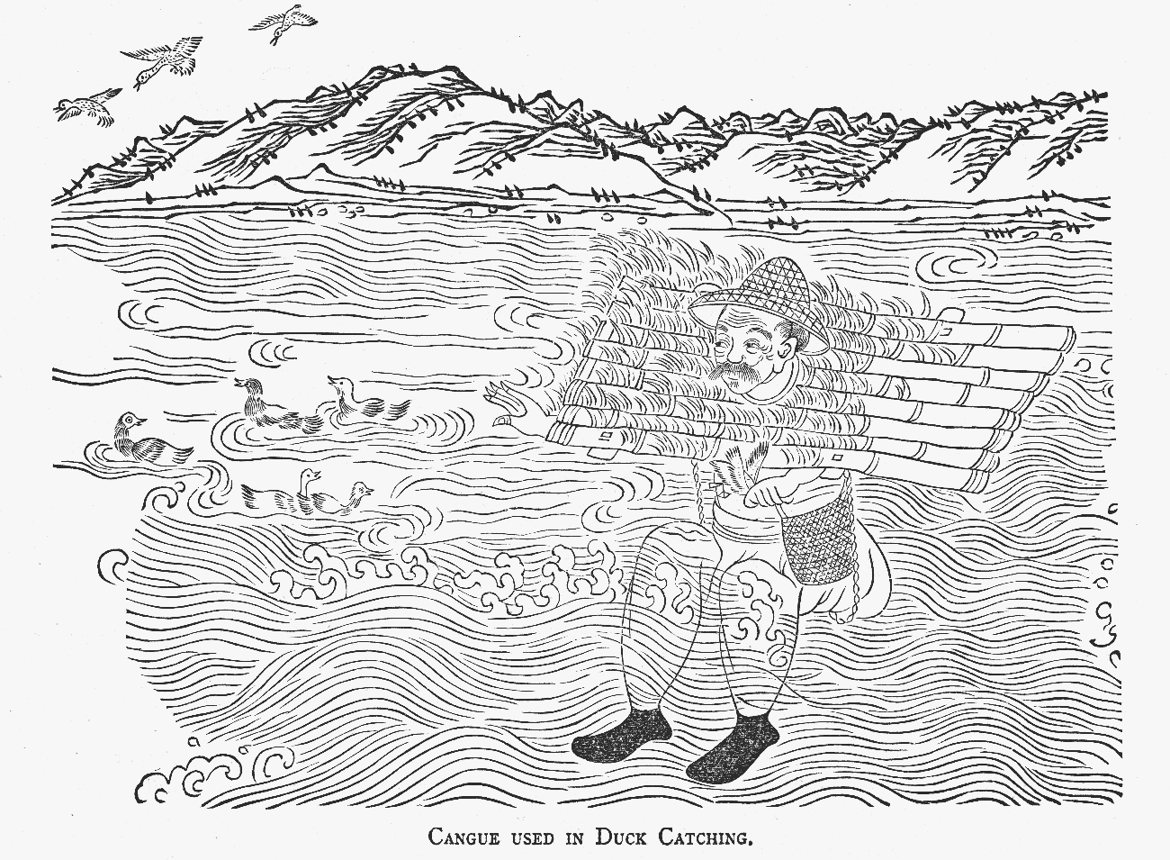
Figure 1.1. A fowler in the middle Yangzi region in the late nineteenth century.
If managed correctly, flooding did not have to be a problem for farmers. In Bangladesh, rural communities distinguish between borsha floods, which they depend on for regular agricultural production, from bonna floods, which cause widespread loss of crops and life.Footnote 124 Those cultivating the lowlands of Hubei drew similar distinctions. They were drawn to areas such as lakeshores precisely because they were flood-prone, as they knew that the regular rise and fall of water deposited rich halos of fertility.Footnote 125 In the 1910s the poet Luo Han 罗汉 described how those who cultivated lakes to the north of Wuhan reaped great fortunes from the nutrient-rich soil.Footnote 126 This agricultural strategy was not without risks, as entire harvests could be destroyed if water was overabundant. Yet with considerable skill and a little good fortune, the profits accrued during good years easily made up for occasional losses.Footnote 127
For those unable to maintain this delicate balance, lakeshore agriculture could become a poverty trap. The regular loss of crops meant that some communities subsisted on little more than wild plants. Local histories relate descriptions of lakeshore communities who were so poor that their residents became infertile.Footnote 128 While travelling through rural Hubei in the 1880s, Archibald Little was confronted with this stark poverty. ‘Nothing could be more wretched than the appearance of the few villages we passed – collections of ten to twenty reed-huts perched on the top of a steep mound, which is covered to the water's edge with buffalo dung.’Footnote 129 Flooding was often both a cause and a consequence of economic distress. The only places that people could afford to live were the same places that kept them poor.Footnote 130 This was not unique to Hubei. In flood-prone regions of northern India members of lower castes can often be found in disproportionately high numbers in littoral areas around the edges of elevated settlements, their social marginality consolidating them in a position of geographic vulnerability.Footnote 131
Chronic water control problems had serious health effects, which cascaded into further economic problems. By the early twentieth century snail fever was so rife that it infected around 10 million people nationwide, killing around 400,000 annually.Footnote 132 People living in infectious zones could do nothing but leave, meaning that large tracts of fertile land remained uncultivated. In Hanyang County, snail fever wiped several dozen villages off the map. Those who refused to be pushed off their land by molluscs soon developed debilitating symptoms, which further hindered their economic productivity. Late-stage snail fever sufferers developed hugely distended stomachs, a symptom so notorious that locals named the condition ‘big belly disease’ 大肚子病 (da duzi bing). Snail fever was particularly prevalent in the villages around Dongxi Lake 东西湖, where eight out of ten people were infected. Residents of this area, so it was said, could be easily identified, as their stomachs entered the room before the rest of their bodies.Footnote 133 For those living in such conditions, floods merely amplified ongoing problems – they caused epidemic outbreaks of endemic poverty.
Few epidemics of poverty surpassed that caused by the catastrophic 1849 flood. In some ways this disaster adhered to the typical pattern found in the region, having been caused by heavy summer rains in Hubei, Hunan and Sichuan. Yet the flood also coincided with – and was perhaps precipitated by – a highly unusual period of cold weather in June. The residents of Wuhan, who would ordinarily be sweating in the oppressive humidity of the early summer, instead found themselves wearing furs and skins.Footnote 134 Curiously, at the same time, their counterparts in the southern United States were experiencing similar conditions, with a cold and wet spring in the tributaries of the Mississippi helping one of the worst floods in the history of New Orleans.Footnote 135
As rural communities across Hubei descended into famine, in Wuhan another deadly secondary effect of flooding seemed to be raising its head. The geographer Edward Oxenham suggests that the 1849 flood precipitated an outbreak of cholera.Footnote 136 Reconstructing the history of this disease in China is fraught with difficulties. The term huoluan 霍乱, which in the modern era came to signify a specific condition caused by cholera vibrio, had been used for millennia as a generic term for any kind of acute gastrointestinal distress.Footnote 137 Believing that China was the fountainhead of all things infectious, foreigners often assumed that references to huoluan in ancient medical texts were evidence that modern cholera had been present in the country since time immemorial.Footnote 138 This was not the case. It is likely that foreigners themselves imported cholera into China during in 1820s, with the vibrio travelling along shipping routes from their home in deltaic India.Footnote 139
Cholera quickly found a niche in the cities of the middle Yangzi, and thrived when humans were pushed into contact with infected water in the summer months. Along with other enteric conditions, it proved particularly lethal to overcrowded settlements of flood refugees who lacked any sanitary provisions. Thus established, cholera became a defining component of the modern disaster regime. It was already exacerbating the effects of flooding in the Yellow River in 1821.Footnote 140 Alongside typhus, malaria and dysentery, it would become one of the leading causes of death during nineteenth century famines.Footnote 141 Historians have paid relatively little attention to the role that modern diseases played in modern disasters. The epidemiological transitions of this era had a profound influence on the nosological profile of hazards. Populous yet unsanitary cities linked by rapid transportation created new possibilities for transmission of pathogens.Footnote 142 These new disease ecologies proved lethal to large populations of refugees, thus greatly exacerbating the humanitarian consequences of the disaster regime.
Even by the standards of the nineteenth century, the 1849 flood seems to have had been particularly devastating. The poet Ye Diaoyuan 叶调元 wrote of a million homes washed away by water, impoverished refugees starving to death on the streets and women forced to sell themselves into prostitution. A prevalent theme in his poems was the inequality of disaster outcomes. Wealthy people had fled for safety while poor people had simply died. The rich transported their dead for burial on local hillsides, while the poor were forced to abandon corpses to floodwater. Those who lived in large houses moved to higher storeys, while the lowly houses of the poor were reduced to rubble.Footnote 143 While residents of Wuhan were experiencing the inequality of disaster outcomes, their counterparts in New Orleans were also discovering the profound influence that household income has during floods. When the city was inundated, wealthy people ‘vertically evacuated’ into the upper storeys of their homes, while their poorer neighbours were forced to flee from single-storey shacks to higher ground.Footnote 144
The cultural historian Andreas Bernard has linked the desire of modern urbanites to live in upper storeys to the invention of the lift. In modern cities such as Paris and New York, mechanical lifts helped to transform inconvenient garrets into desirable penthouses.Footnote 145 Yet in flood-prone cities such as Wuhan and New Orleans, height had always been a premium commodity, demonstrating that there was more than one form of architectural modernity. In Hubei, there was a distinct convergence between the literal and figurative stratification of the urban landscape. Wealthier citizens built large timber-framed buildings on strong stone or earth foundations, with walls constructed from a variety of materials including brick, stone, timber and bamboo.Footnote 146 Those with fewer resources constructed housing frames from cheap timber or bamboo and made walls from tamped earth, thatch or woven reeds. During floods, humble houses dissolved in water or were torn from the landscape, leaving nothing but skeletal wooden frames.Footnote 147 At the literal and figurative bottom of the urban landscape people lived in huts 棚子 (pengzi) or low houses 矮屋 (aiwu), which offered virtually no protection from flooding.Footnote 148
Nowhere was the convergence of literal and social stratification more evident than on the riverbanks of cities. Here river merchants lived in stilt houses that would remain above rivers even during the wet summer months. On the banks below people lived in shacks and huts, where they had to contend not only with unpredictable watercourses, but also with sewage and rubbish being thrown down from stilt houses.Footnote 149 Some shacks were constructed from urban detritus – discarded planks, pieces of broken metal or anything that could be gleaned from the city above.Footnote 150 Other huts were knitted together from reeds, which grew in thick stands on riverbanks and lakeshores often reaching a height of four or five metres.Footnote 151 The reed huts that stood on the riverbanks of Wuhan (Figure 1.2) were known colloquially as duck eggs 鸭蛋 (yadan).Footnote 152
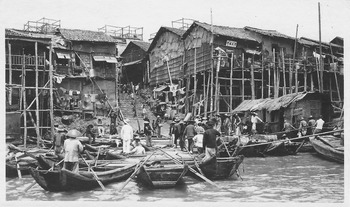
Figure 1.2. The Wuhan riverbank in the early twentieth century.
Huts offered little protection from the elements, and could easily be washed away by flash floods, yet had the advantage of being cheap and portable. Their occupants could cope with the threat of flooding using one of the most venerable of techniques – evacuation. The occupants of duck egg shacks lived a semi-nomadic existence, moving their homes to high-ground refugia when rivers rose in the summer. Living in a hut, though hardly desirable, was a pragmatic adaptation to a hazardous environment, which allowed people to survive on the littoral and economic margins of the city. To survive this life, one had to be keenly attuned to minor environmental changes. Riverbank communities knew that when the Yangzi assumed a copper hue it was time to move, as there must have been heavy rain upstream in the red sandstone basin of Sichuan.Footnote 153 Such signals served as natural early warning systems for the poor, and were a key component of the wetland culture that helped them to live with floods.
There was also a city beyond the riverbanks – one that floated. The Yangzi and Han did not form a hard border; their surfaces extended crowded streets and alleyways out onto the water. Many people worked, slept and ate in floating neighbourhoods. The customs official G. R. G. Worcester estimated that by the twentieth century there were 25,000 junks engaged in traffic between the Wuhan cities. ‘They lie 10 or 12 abreast on both the banks of the Han River for a distance of 5 miles back and are packed so close that the Chinese expression “like scales on a fish” is not inappropriate.’Footnote 154 These vessels came in all shapes and sizes, from the humble sampans that darted about the harbour unloading larger junks to opulent floating brothels known as flower boats 花船 (huachuan).Footnote 155 Just as riverbank neighbourhoods advanced and retreated with the rise and fall of water, so too did this floating city. When Wuhan was inundated, those who lived and worked on the water often encroached beyond the riverbanks; their sampans became water taxis and floating markets. For those habituated to a life on water, flooding was not just a disaster. It was also an opportunity.
A Water-Plagued Land
During the late nineteenth century, a new wave of migrants began to colonise the riverbanks of Wuhan. Under the terms of the 1858 Treaty of Tianjin, the British had been granted the right to navigate the river and build a settlement in the newly designated treaty port of Hankou. Many new arrivals believed the devastating floods that they witnessed in their new home were simply a pathological feature of the local environment. The geographer Edward Oxenham claimed that the natural sloping of the earth coupled with incessant rainfall had conspired to turn Hubei into a ‘water-plagued land’.Footnote 156 What foreign observers mistook for environmentally determined inundations were in fact the symptoms of a hydraulic crisis. The decline of Qing infrastructure had been greatly exacerbated during the Taiping Civil War (1850–1864), when Hubei had endured waves of invasion and counter-invasion. This caused the already ailing hydraulic network to spiral into complete decay. Dyke breaches went unrepaired for years on end, and in 1856 Qing commanders militarised a tributary of the Han River, opening the sluice gates to drown their Taiping enemies.Footnote 157 Such strategies may have helped to quell the insurgency, yet they came at a huge humanitarian cost. Some 20 million people lost their lives before the Taiping Heavenly Kingdom was defeated, making this probably the most lethal civil conflict in history.Footnote 158 The war helped to turn much of China into a water-plagued land. Communities living in the Huai and Yellow River basins faced a series of calamitous floods, which were second only to droughts in their humanitarian cost.Footnote 159 By crippling infrastructure and draining resources, warfare had helped to forge a lethal disaster regime. It would continue to do so over the next century.
The Taiping Civil War was not the only conflict raging in the mid-twentieth century. Foreign powers, led initially by the British, launched a series of attacks upon the sovereignty of the Qing Empire. Lying well beyond the coast, Hubei was rarely at the centre of these conflicts. It was influenced by these wars, nonetheless, particularly when Hankou was designated as a treaty port. British High Commissioner James Elgin, who sailed his gunboat up the Yangzi to reconnoitre Hankou, was sorely disappointed. Having read tantalising descriptions of the great commercial entrepôt, he found a city ‘almost completely destroyed’ by the Taiping invasion. Wuchang was little better. Though there were the ‘remains of some buildings of pretension’, most areas had been ‘sadly mistreated by the Rebels’.Footnote 160 As Wuhan recovered over the next few decades, it continued to be plagued by both urban inundations and devastating provincial floods. Between 1869 and 1872, almost all of Hubei was subsumed under water three times.
These floods proved so serious that administrators finally decided to heed the advice of non-interventionists such as Wei Yuan, and allow two natural breaches in the river dyke network to remain unrepaired.Footnote 161 Flood peaks would now flow south towards Dongting Lake. This eased the pressure on the Great Jingjiang Dyke, which would not collapse again until 1931.Footnote 162 Yet many of those living around Dongting Lake were not impressed with this solution. The population of Hubei had discovered one of the most effective means of preventing inundation – drown your neighbour's land. The zero-sum nature of water control ensured that hydraulic systems remained a perennial source of political conflicts, not only prompting tensions with neighbouring provinces, but also generating bitter inter-village disputes. This was not unusual. In Ottoman Egypt, neighbours often took to the courts to settle disputes over irrigation channels, while in Louisiana plantation owners became embroiled in prolonged feuds over levees.Footnote 163 Most disputes in Hubei centred on issues of dam and sluice construction. They were known to precipitate violent altercations between whole communities, which could last for decades. On some occasions the government was forced to send troops to demolish illegally constructed dams and quell popular unrest.Footnote 164
Among the many communities struggling for hydraulic security during this period were the Britons of treaty port Hankou. Eschewing the insecurity of what they referred to as the native city, they built a segregated concession on the banks of the Yangzi. For the first few decades, this concession failed to live up to their grand expectations. When Archibald Little visited in the 1880s, he noted that the place had ‘the lifeless depressing aspect’ much like that of ‘a seaside watering-place, in the off season’.Footnote 165 Things changed dramatically in 1895 with the signing of the Treaty of Shimonoseki. This allowed the French, Germans, Russians and Japanese to build their own concessions. Eventually these formed a contiguous strip, fronted by an embanked riverbank known as a bund. In practical terms, this prevented the river from rising into the concessions and served as a convenient location for wharfs and warehouses. Yet the bund also allowed foreigners to stamp their alien physical signature upon the city.Footnote 166 Travellers arriving in Wuhan were confronted by an imposing skyline of consulates and banks, behind manicured gardens and avenues of trees. The bund was central to the founding myth of the Britons of Hankou. They pictured themselves wrestling a tiny sliver of stability and civilisation from a malaria-ridden swamp on the fringes of an exotic city.Footnote 167 This bore an uncanny resemblance to the story that Britons liked to tell about the founding of Shanghai, in which ingenious foreign engineering was pictured civilising a watery Chinese wasteland. While this narrative bent the truth in Shanghai, in Hankou it broke it altogether.Footnote 168 The riverbank area had been populated for centuries and the bund was built on the same kind of platform that people in Hubei had been employing for millennia to avoid water.Footnote 169
The bund made a rather minor contribution to the hydraulic safety of Wuhan. Floodwater did not generally enter the city from the rivers, but from the lakes and wetlands to the northwest. Every summer these filled with water, and in wet years this ran into the city streets. The wetlands reclaimed Wuhan three times between 1887 and 1889, finally prompting the local government to take definitive action.Footnote 170 The renowned Qing statesman Zhang Zhidong 张之洞, then serving as governor of Hubei, ordered the construction of a large dyke network to surround the city.Footnote 171 Wuhan would continue to suffer waterlogging, yet these urban flood defences offered several decades of respite from major inundations. The dykes also changed the perception of risk. In the aftermath of the 1931 flood, the missionary H. Owen Chapman would observe that the defences had been built so well that much of the urban population had forgotten that they were ‘living under Dutch conditions, several feet below the average and twelve feet below the maximum summer level of the great river’.Footnote 172
Flood defences lulled people into a false sense of security. Soon they began to build a dry land city in the middle of the wetlands. Vernacular architecture, which used materials such as wood and reed that could be repaired easily following floods, gave way to more rigid architectural styles, wrought in brick and stone. These new materials allowed Wuhan to cloak itself in the garb of modernity. The brick shopping malls, banks and tenements that sprang up around the city soon dwarfed the timber shop houses and guild temples that had once dominated the skyline. The brickification of Wuhan was the ultimate expression of sedentism – an architecture of permanence created by a culture confident in its abilities to keep itself dry. With the new dyke preventing the north from turning into a giant lake during the summer months, Wuhan sprawled ever further out into the wetlands. By the 1920s it formed the vast conurbation that can be seen in Figure 1.3. The new land created opportunities for novel forms of urban space, such as the large private garden that the businessman Liu Xinsheng 刘歆生 constructed in the north of the city, which the city government would later transform into Sun Yat-sen Park.Footnote 173 The foreign population turned their stretch of marshland into a playground for the leisured elite, complete with a racecourse, golf links and swimming pool.Footnote 174 Easily the most important development in this newly reclaimed area was the railway line that linked Hankou to Beijing. The embankment elevated trains above the plains and also acted as an extra barrier against flooding.Footnote 175
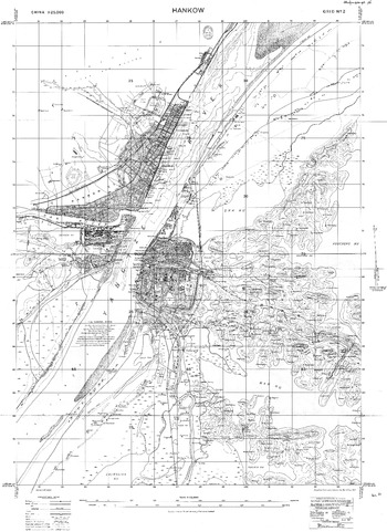
Figure 1.3. A map of the three Wuhan cities in the late 1920s.
This urban sprawl had a dramatic effect upon the local environment. In 1910, a foreign hunter named E. G. Bryrne described how the ecological shadow cast by the modern city was already beginning to deplete the wildlife found in the surrounding hinterland. Although the new dykes had helped to prevent summer floods, he noted that they had also
…brought about the ploughing up of considerable areas of grass lands, and so limiting the snipe grounds…One can no longer make a big bag near the French Consulate, now in the centre of the Settlement, nor around the walls of Hankow, while further out, the railway depot, oil installations and factories occupy the ground that used to be the haunts of the pintail…One unfortunately cannot take any hopeful view of the future of shooting round Hankow.Footnote 176
These oil installations and factories formed part of a wave of industrialisation that had begun to sweep over Wuhan in the 1890s. Once again, Zhang Zhidong had played the principal role in precipitating this seismic change. Although there were already some small-scale foreign enterprises in Wuhan, most notably a Russia brick tea factory, it was the state-sponsored iron and steel works and the arsenal in Hanyang that initiated urban industrial transition.Footnote 177 Factory chimneys were soon rising across the urban landscape. They manufactured a vast array of products, ranging from matches and cigarettes to machinery parts and powdered egg.Footnote 178 These new industrial products were sold alongside local agricultural goods, such as rice, sesame, tobacco and sugar; more exotic items from upstream provinces, such as medicinal plants, furs, musk and opium; and also foreign imports, such as kerosene, petroleum and milled flour.Footnote 179 Shanghai may have been the Paris of the Orient, but Hankou was Chicago of the East 东方芝加哥 (Dongfang Zhijiage) – a port city with thriving docks through which people and produce never stopped flowing.Footnote 180
Industrialisation would eventually revolutionise the relationship between humans and rivers, as concrete and steel replaced tamped earth and stone. The Nationalist leader Sun Yat-sen had a clear vision of how China could use these new materials to exploit its hydraulic potentials. In the late 1910s, he promulgated a plan to prevent floods and extend electrification by damming the Yangzi.Footnote 181 Although these ambitious objectives would finally be fulfilled a century later, at the time they were distinctly unrealistic. While politicians dreamed about damming rivers, they were incapable of maintaining the simple tamped earth dykes that they had inherited from their imperial predecessors. In 1910, the dykes along the Han broke, leaving thousands living in huts throughout the winter.Footnote 182 The fall of the Qing the next year brought no respite. The dawn of the new Republic was marked by serious flooding along the Yangzi and Huai basins in 1912.Footnote 183
The collapse of imperial prohibitions against land reclamation precipitated a renewed assault on the wetlands. Farmers could now colonise rivers and lakeshores in exchange for certificates of ownership.Footnote 184 The Department of Agriculture and Forestry established by the Beiyang government was dismissed by many contemporary critics as an entirely cosmetic gesture. The historian Deng Tuo 邓拓 remarked on the irony of politicians holding special tree planting events while elsewhere forests were being driven to the point of extinction.Footnote 185 The militarists who ruled Hubei in the early Republic were not totally inactive. Xiao Yaonan 蕭耀南 commissioned a far-reaching survey of the hydraulic network with the intention of addressing the deteriorating conditions of flood prevention.Footnote 186 Yet incessant warfare prevented any meaningful rehabilitation. In 1921 Wu Peifu 吴佩孚 demonstrated his priorities, blowing up one of the most important dykes in eastern Hubei in order to drown an invading army led by the rival militarist Xia Douyin 夏斗寅.Footnote 187
More serious than these individual acts of sabotage was the unsustainable burden that the economics of war placed on the local environment. This was a symptom of what Edward McCord has described as the ‘predatory warlordism’, a parasitic mode of governance that blighted Hubei in the 1910s and 1920s.Footnote 188 To fund their military adventurism, and often also to line their pockets, warlords embezzled funds earmarked for hydraulic maintenance. They also cut down trees that were planted in dykes to prevent erosion so they could sell the timber.Footnote 189 The hydraulic network was left in such a perilous state that by the time that the Nationalists began to advance on Wuhan in 1927, dykes throughout Hubei began to collapse. Only a herculean effort on the part of the local workforce prevented floodwater from bursting through the dykes surrounding Wuhan.Footnote 190 Disaster was averted this time. Five years later the city was not so lucky.
Weathering the Storm
The 1931 flood was not an isolated incident. During the late 1920s and early 1930s the world witnessed a succession of weather-induced catastrophes. When the rains failed in eastern Rwanda between 1928 and 1930, as many as 40,000 people died.Footnote 191 At approximately the same time, a severe drought struck northern China, killing 10 million.Footnote 192 In 1930, French Indochina succumbed to a drought-induced famine, which proved particularly lethal in Vietnam. The desiccation of the Southern Plains of the United States helped to create the Dust Bowl, one of the most iconic images of this troubled era.Footnote 193 Meanwhile in the Soviet Union, between 1932 and 1933 drought and crop diseases contributed to the horrific humanitarian catastrophe that may have killed as many as 6 million people in the Ukraine.
The role that the climate played in each of these disasters remains as confusing as it is contentious. Unlike the 1780s or 1870s, when we can be confident in tracing links between disasters and El Niño events, the teleconnections that existed in the 1920s and 1930s were complex and fragmented. Though some climatologists have detected an alternating succession of El Niño and La Niña events between 1928 and 1933, this was not a period of coherent ENSO activity.Footnote 194 Even if it were possible to reconstruct the climatic history of this period with any degree of accuracy, we would still need to exercise caution when drawing causal links between climatic anomalies and humanitarian catastrophes. Historians are often seduced by the allure of ENSO, which offers a neat explanation for disasters while also binding them to a climatic process with a distinct celebrity status. What we sometimes forget is that temporal correlations do not necessarily imply teleconnections – just because a climatic hazard coincided with an ENSO event does not mean it was caused by it.
More importantly, none of the foregoing catastrophes were entirely natural disasters. Drought may have may have destroyed harvests in Rwanda and Vietnam, yet the subsequent famine was also caused by Belgian and French colonial policies, which were themselves influenced by the general economic malaise of the Great Depression.Footnote 195 Likewise, a dearth of rain killed crops in northern China, yet it was internecine warfare that drove millions into starvation, while broader processes of systemic decline, similar to those detailed in this chapter, had left them chronically vulnerable.Footnote 196 Stalinist agricultural collectivisation, rather than drought and wheat rust alone, helped to plunge the Soviet Union into famine.Footnote 197 Finally, although an acute water shortage may have helped to whip up dust storms, the calamity suffered by American farmers had been incubated by decades of unsustainable agricultural expansion.Footnote 198 In each instance, the climate was a proximate cause but not the sole determinant of disaster. This was also the case during the 1931 Central China Flood.
The cold winter of 1930 caused a heavy build-up of snow in the upper Yangzi. This may possibly have been influenced by the El Niño event of the year.Footnote 199 Similarly, the heavy rains that fell throughout 1931 may have been caused by the onset of a La Niña event.Footnote 200 Whatever the climatic cause, we know that 1931 was incredibly wet. Early in the year, melting snow and ice flowed downstream from Tibet, arriving in the middle Yangzi at the same time as a period of heavy spring rain. Ordinarily the region experienced three waves of high water, during the spring, summer and autumn; in 1931, there was just one continuous deluge. By June those living in low-lying areas had already been forced to abandon their homes.Footnote 201 In an average year this region might expect to experience two cyclonic storms; in 1931 seven occurred in July alone.Footnote 202 The water flowing through the Yangzi had soon reached the highest level since records were first kept in the mid-nineteenth century.Footnote 203 There was no possibility that the rivers of Hubei could drain this huge volume of water through their artificially restricted channels. Neither could the ailing flood defence system withstand the extreme pressure of water. In the early summer the Great Jingjiang Dyke failed for the first time in sixty years. The water that flowed through multiple breaches went on to compromise 90 per cent of the dykes on the Jianghan Plain.Footnote 204 Still the rain did not stop. It continued throughout the summer, culminating in another series of storms in the early autumn. High winds swept across the inundated landscape, whipping floodwater into a series of devastating waves.Footnote 205 Water began to recede only in the midautumn, yet even then large tracts of land remained inundated, as the polders that had been built to keep water out now turned into reservoirs.
This flood would not have occurred were it not for nature. Yet the rain that fell drained through a landscape that had been modified by thousands of years of human action. It flowed over denuded slopes and reclaimed wetlands into channelised rivers. Its force was amplified by the constructed landscape that people had built to keep themselves dry. Having domesticated the natural resistance out of plants and animals, and placed them in areas vulnerable to inundation, farmers had created a subsistence system that relied on predictable meteorology, all the while living under unpredictable skies. Agriculture, urbanisation and trade had cultivated diseases that rose to epidemic proportions during floods. The cumulative effect of all these dynamic interactions had established a lethal disaster regime. Long before rain began to fall, all the ingredients for a catastrophe were already in place.


