


1. Background of the Project
Japanese Antarctic Research Expeditions (JAREs) have collected glaciological, climatological and gcochemical data on the ice sheet in east Dronning Maud Land since 1968. As part of the International Geosphere-Biosphcre Programme and the International Trans-Antarctic Scientific Expedition, the Dome Fuji Project (DFP) was designed as a comprehensive study of past and present glaciological/ climatologieal features of the Antarctic ice sheet in east Dronning Maud Land.
The principal parts of the project are the glaciological traverse from the ice-sheet margin to the top of Dome Fuji and the deep ice-coring at Dome Fuji station. The project was carried out hetween 1991 and 1996.
2. Traverse Study
The oversnow traverse party of the JARE conducted glaciological and climatological observations, and in 1985 fixed the location of the second highest dome in Antarctica (Reference Ageta, Kamiyama, Okuhira and FujiiAgeta and others, 1989). in 1991 and 1992 the DFP extended the study area from the coastal area to Dome Fuji, which is the summit of the Shirasc and Ragnhild drainage basins (Reference Kamiyama, Furukawa, Maeno, Kishi and KanauKamiyama and others, 1994; Reference Fujii, Motoyama and AzumaFujii and others, 1995). Glaciological data including surface elevation, ice ihickness, sur-faee ice velocity, snow accumulation, snow temperature-depth profiles, stratigraphie and density profiles and snow surface features were collected along the traverse routes.
2.1. Regional Characteristics
Figure 1 shows a cross-section of the ice sheet (surface and bedrock elevation) and the distribution of snow accumulation (October 1991 -December 1995) along the traverse route from the coast to Dome Fuji.
Reference Furukawa, Kamiyama and MaenoFurukawa and others (1996) showed that the traverse route can be divided into three sections on the basis of the characteristics of snow surface features: a coastal region, characterised by a high frequency of small sastrugi and low frequency of dunes; a katabatic-wind region characterised by the coexistence of small and large sastrugi, dunes and a glazed surface; and an inland region characterised by low frequencies of small sastrugi and dunes. These regional characteristics of snow surface features are due to deposition erosion processes influenced by both the surface and bedrock topography of the ire sheet.
2.2. Ice-flow velocity
Ice-flow velocities at glaciological survey points along the traverse routes are shown in Figure 2. Data were obtained by chain survey, by satellite Doppler positioning and by differential global positioning system (GPS) (Reference NaruseNaruse, 1978; Nishio and others, 1989; Reference MotoyamaMotoyama and others, 1995a I. Naruse (1978) and Nishio and others (1989) showed that east Dronning Maud Land can be divided into live drainage basins: the Soya, the Shirasc, the Harald, the Ragnhild and the Asuka. Measurement of horizontal and vertical flow velocity, strain rate, inclination of the ice surface, accumula-tion rate and dcnsilication of snow was used to show that the ice sheet in the Shirase drainage basin at elevations below about 2800 m is thinning.
2.3. Surface and bedrock topography of Dome Fuji
The surface topography of the dome (see Fig. 3) is very smooth and flat. The surface elevation at six radial points 30 km from the summit is only 7 30m (mean 20m) lower than the summit, and the mean surface slope within a radius of 30 km is estimated at 1/1500.
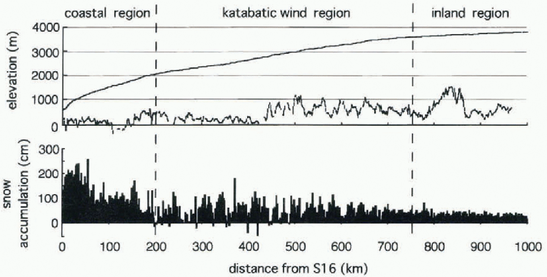
Fig. 1. Surface and bedrock profiles of the ice sheet and the distribution of net snow accumulation from October 1991 to December 1995 along the traverse routefrom the coast to Dome Fuji.
A topographical map, based on radio-echo sounding data collected in 1992-93 (Reference MaenoMaeno and others, 1994) from the bedrock around Dome Fuji is shown in Figure 3.
The location of Dome Fuji station was decided on the basis of both surface and bedrock topography. The station is situated above relatively flat bedrock with an elevation of about 800 m. The bedrock topography around the dome shows what appears to be a saddle point with bedrock hills more than 1000 m a.s.l. to the southeast and the northwest, and bedrock elevation below 600 m to the northeast and southwest.
2.4. Drilling-site
Drilling-site parameters were investigated by surface observations, snow-pit measurements and analysis of 10 m cores (Ageta and others, 1989). Measured parameters arc:
-
(1) Location: 77°19'01"S, 39°42'12"E
-
(2) Altitude: 3810 m a.S.l.
-
(3) Ice thickness (estimated from radio-echo sounding): 3090 m
-
(4) 10 m snow temperature: -58.0°C
-
(5) Mean annual net accumulation (measured 1966-85): 32 mm w.e.

Fig. 2. Horizontal ice-flow vectors (ma−1) obtained from satellite Doppler positioning (Nishio and others, 1989), from the triangulation chain along latitude 72° S (Naruse, 1978) and from differential GPS (Moloyama and others, 1995a). Drainage-basin, ice divides are shown by broken lines (Nishio and Ageta, 1997).

Fig. 3. Surface topography of Dome Fuji (above) and bedrock topography (below).
3. Deep Ice-Coring At Dome Fuji Station
We developed a deep ice-core drilling system after field experiments in Antarctica (in 1988 and 1989), at Dome GRIP, Greenland (in 1991 and 1992), and at Rikubetsu, Japan (in 1992, 1993 and 1994) (Reference TanakaTanaka and others, 1994). in 1993 a pilot hole was drilled to a depth of 112 m and borehole casing was fitted. Dome Fuji station was constructed in 1994 and deep ice-core drilling started in 1995. The drilling reached a depth of 2503 m in 1996.
3.1. Casing
The 135 mm diameter pilot borehole was drilled to a depth of 112 m and was reamed to 250 mm diameter to fit fibre-glass-reinforced casing (Reference Johnsen, Gundestrup, Hansen, Schwander and RufliJohnsen and others, 1994; Reference Morgan, Wehrle, Fleming, Richardson, Elicheikh and BrandMorgan and others, 1994) in 1993 (Motoyama and others, 1995b). The casing was fitted to a depth of 86 m. Prior to deep ice-coring in 1995, the casing was sealed at the bottom by refro-zen wet snow to prevent the drill from catching against the bottom end of the casing when it was pulled up.
3.2. Borehole liquid
The borehole liquid was carefully chosen from the viewpoints of viscosity and density at temperatures as low as -60°C; effects on ice-core quality, drill and human health; environment; and fiammability or volatility (Reference Fujita, Yamada, Naruse, Mae, Azuma and FujiiFujita and others, 1994). Eventually, N-butyl acetate was chosen which has low viscosity and appropriate density for the temperature at Dome Fuji.
3.3. Drill system
Table 1 shows the fundamental specifications. The drill was designed to be (i) light, (ii) easy to operate and (iii) safe under conditions at Dome Fuji (Tanaka and others, 1994).
The drill is of the double tube type. It consists of an outer tube and an inner barrel (or core barrel) 2.25 m long fitted with three cutters. Spirals are attached to the outside of the inner barrel to transport chips upward while the barrel is rotating. The chips are forced into a 3.3 M long chip chamber, located above the core barrel, by a lilt-like booster. The motor, reduction gear and computer seclioit MIC located in a sealed chamber designed to withstand the pressure of a 3500 m deep lluid-loaded borehole.
Table 1. Specification of the deep ice-core drilling system used at Dome Fuji
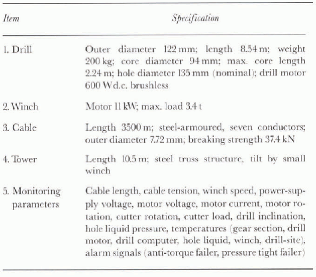
The drill transmits 25 operational parameters every second to a computer at the surface. The most importani parameters I cable tension, cutter load, drill inclination, etc.) are shown graphically against depth or time to assist drilling and winch operations.
The winch speed can be delicately controlled to speeds as slow as 1 cm min−1. For safety and ease of operation, threshold values of depth and cutler load can be set. which if exceeded stop lite winch. Alarm signals can also be set to draw the operators attention to any abnormal operation.
Because of the drill's low energy consumption, a generator of 22.4 kW has enough capacity to power the total drill system even when the core-processing line (which uses additional power) is active.
3.4. Drilling operation
The deep drilling started on 23 August 1995 from the bottom of the pilot hole at a depth of 112 m. The drilling terminated at a depth of 2503.52 m on 8 December 1996. Drilling was carried out in two shifts with two operators on each shift. Typical hoisting and lowering speeds were 70—80 and 80-90 cm min−1, respectively. The average time for cutting a 2 m core was 20 min. The temperature of the drilling-site was kept in the range 25° to -35°C, even in the winter when the outside air tempera!lire dropped below -70°C, by injecting warm air from the generator hut with a blast lube.
The total number of drilling runs was 1370, and 836 chip collection runs were made. The average length of core obtained per run was 1.75 m.
Core quality was excellent over the full length of the core, even in the brittle zone between 500 and 840 m depth. The good core quality is thought to be mainly due to the small cut rate, which was kept as low as 2 mm rev.−1 because of the ice hardness at temperatures of -50° to -60°C. in the top 1800 m the borehole was kept almost vertical, with inclinations less than 0.5°. The inclination then increased gradually to 4.6 at 2250 m depth. At greater depths, the inclination decreased.
Borehole liquid temperature increased from -55°C at shallow depths to —20°C at 2500 m. Chip collection gradually improved with depth, particularly at depths below 2000 m, where a larger depth of cut could be used. Nevertheless, we still needed to set aside at least one day a week for chip collection runs. Figure 4 shows the penetration rale and daily coring depth during the drilling in 1995 and 1996.
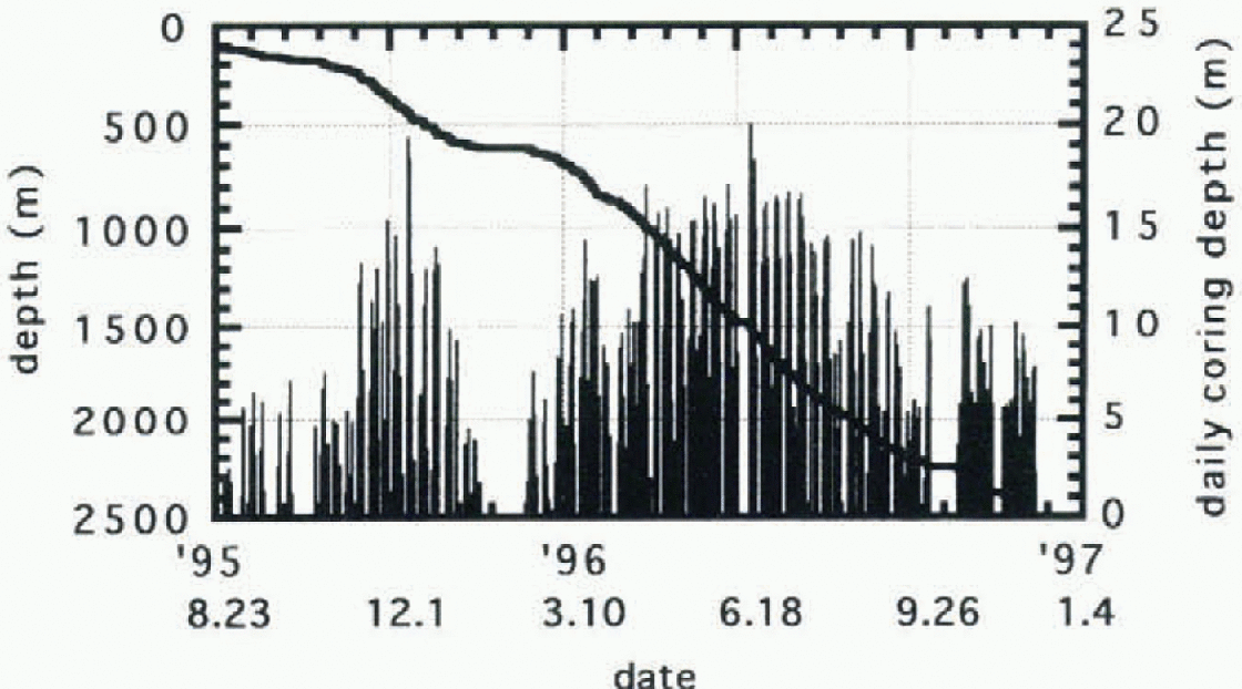
Fig. 4. Drilling progress at Dome ruji in 1995 and 1996.
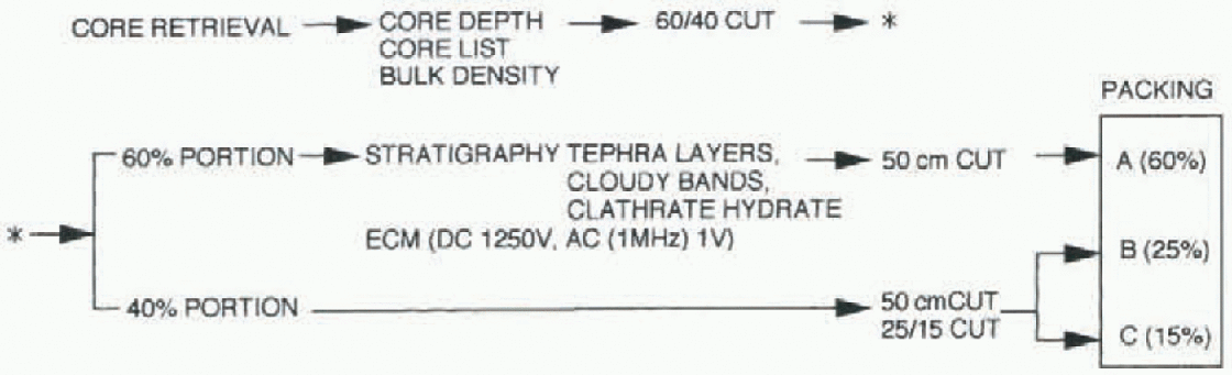
Fig. 5. In situ core-processing procedure at Dome Fuji.
4. In Situ Core Analysis
In situ core analysis consisted of electrical conductivity measurements (ECMs), stratigraphieฝ observation and bulk density measurements. ECM included both d.C. measurements (Reference HammerHammer, 1980) anda.C. measurements (Reference Minikin, Kipfstuhl and OerterMinikin and Kipfstuhl, 1993; Reference Sugiyama, Fujita, Sucoka, Mae and HondohSugiyama and others, 1995). Stratigraphical observations included careful examination of lephra layers, cloudy bands and air bubbles/clathrate hydrate.
The analysis was carried out in a snow-trench laboratory next to the drilling-site. Drilled cores were stored for 1-4 months before processing and analysis. Figure 5 shows the core-processing procedure carried out at Dome Fuji.
In the processing line, logging and bulk density measurements were made prior to any core-culling. The cores were then cut in two along the core axis in the ratio 60 : 40. The a.C. and d.C. ECMs and stratigraphical observations were performed on the cut surface of the larger core section. At the end of the core-processing line, the smaller section was further cut in two to give three core pieces as shown in Figure 6, Each of these core pieces was then cut into 50 cm sections for packing. The analysis-room temperature was normally kept at around 25°G for the ECM. ByJanuary 1997, processing had been completed to a depth of 2251 m. Cores from below this depth were processed in the winter of 1997.
4.1. Density
Bulk density measurements were obtained by measurement of core length, diameter and weight. The accuracies of 0.5 cm, 0.005 cm and 0.05 kg, respectively, lead to a standard deviation of the density of around 0.5%. The biggest source of error is the irregular shape of the core ends.
Fig. 6. Core-cutting planjbr the Dome Fuji ice core.
4.2. ECM
The d.C. and a.C. ECMs were measured independently in an integrated system. A block diagram of the system is shown in Figure 7. A laptop computer connected to the ECM measuring system via a General Purpose Interface Bus (GPIB) carried out system control and data acquisition. The d.C. and a.C. ECMs used 1250 and 1 V, respectively. The distance between the electrodes was 15 mm for both d.C. and a.C. ECMs. A Potentiometrie arrangement is used to determine the position of the electrodes. For the d.C. measurement, the recorded signals were direct current (A) and The electrode position. For the a.C. ECM, the measured signals were admittance (both susccptancc and conductance) and the electrode position.
4.3. Tephra layers
Continuous stratigraphical observation down to a depth oi 2251 m revealed 25 layers containing visible solid particles. Two layers were found between 500 and 600 m, while the other 23 were found between 1000 m and 2251 m. The thickness of the layers ranged from 1 to 22 mm. Below 2251m, the limit of the continuous stratigraphical observations, a lephra layer was found at 2268 m. The slope oflhe tephra layers was almost perpendicular to the core axis. The deepest layer has slope of 3° which coincides with borehole tilt, which suggests that the stratification of the tephra layers is almost horizontal, and no effect of bedrock topography is apparent even at this depth.
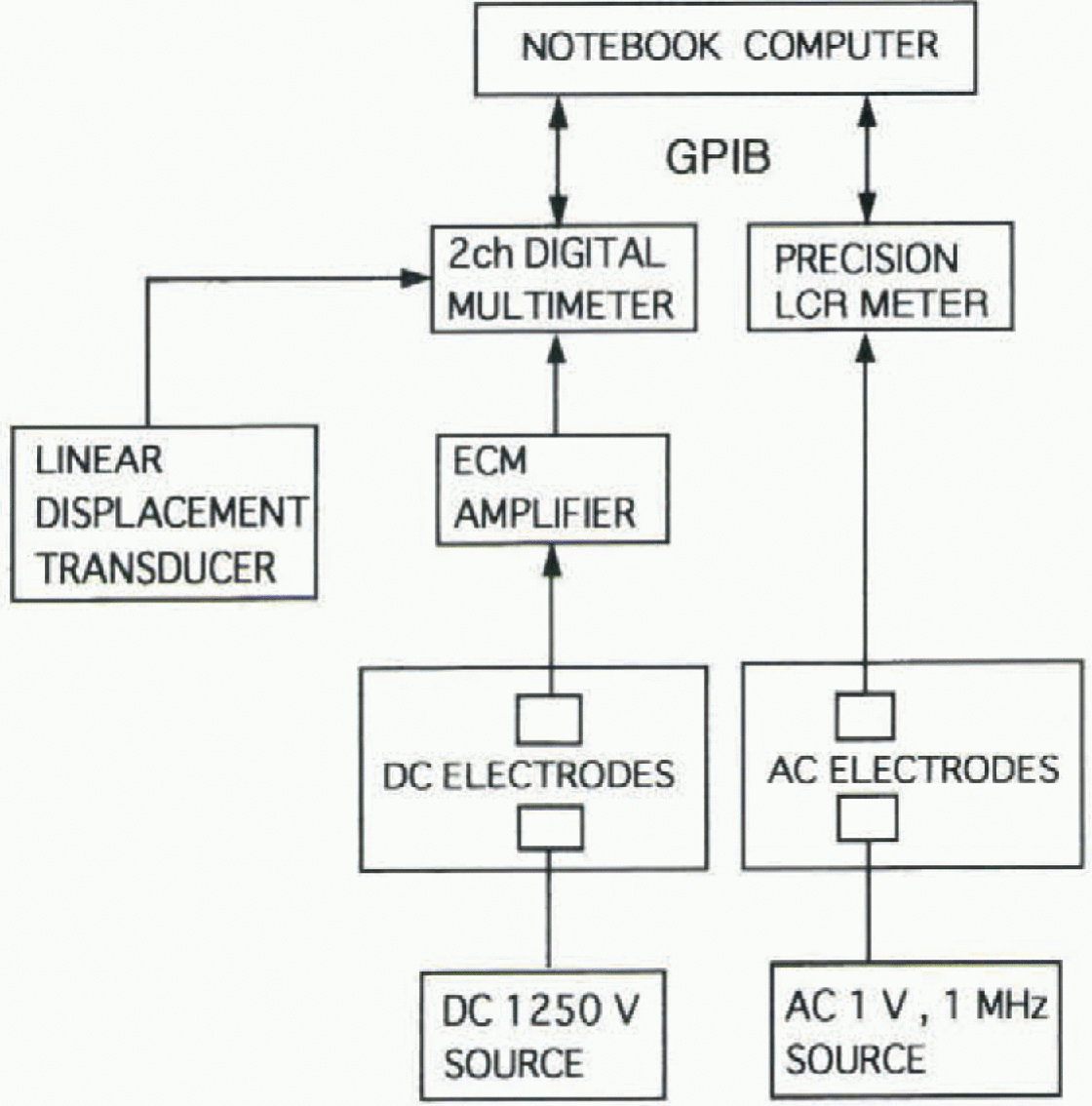
Fig. 7. Block diagram of ECM system.
4.4. Brittle zone
Brittle cores were obtained at depths between about 500 and 840 m. The starting depth of the brittle zone is roughly the same as the depth at which the first cloudy bands and clath-rate hydrate crystals appeared. More than 700 distinct cloudy bauds were found, as well as many indistinct ambiguous layers. Most of these were found in three depth langes, around 550,1000 and 2000 m. in contrast, in the other depth ranges cloudy bands were rare. Visible air bubbles were not observed at depths greater than about 1100 m.


