Introduction
The Antarctic sea-ice cover annually retreats from a maximum area of 20 × 106km2 in September to a minimum of 4 × 10⁶km2 in February (Reference Zwally, Comiso, Parkinson, Campbell, Carsey and GloersenZwally and others, 1983). Consequently, there are significant annual variations in water, salt and heat fluxes, as well as oceanic biological processes in the Southern Ocean. While large-scale global studies using satellite and ground data provide an important tool for defining the mechanisms which control the areal extent of sea ice on an annual basis, small-scale studies are important for better understanding the processes responsible for the growth and decay of sea ice and interpreting satellite data.
The majority of small-scale studies of sea-ice properties have focused on salinity variations in Arctic sea ice (e.g. Reference Weeks and LeeWeeks and Lee, 1958, Reference Weeks and Lee1962; Reference Cox and WeeksCox and Weeks, 1974; Reference Tucker, Gow and RichterTucker and others, 1984). Apart from studies by Reference Eickcn, Lange and DieckmannEicken and others, (1991), which described the spatial variability of ice texture, salinity, chlorophyll a and nutrients from floes in the Weddell Sea, and Reference Danielson and JeffriesDanielson and Jeffries (1992), who have reported on variations of physical properties and structural characteristics of a single floe from the western Ross Sea, there have been few Antarctic investigations of small-scale sea-ice properties and structure.
This study presents the results of an investigation of two Antarctic fast-ice sites, one in the Ross Sea and the other in the Amundsen Sea. Analysis of snow depth, ice thickness, salinity, temperature and crystal structure from both sites, as well as c-axis orientation and plate width from MCM, provide the means with which to investigate the small-scale horizontal and vertical variations between cores as well as the differences in growth histories and conditions between sites.
Study area and methods
The two fast-ice sites selected for this study, one located in the southwestern Ross Sea and the other in the southeastern Amundsen Sea, were visited during a cruise aboard USCGC Polar Sea in the austral summer of 1991-92. Ice samples from the Ross Sea were obtained on 9 January 1992 from fast ice located southwest of the tip of Hut Point Peninsula in McMurdo Sound (Fig. 1). On 4 March 1992, ice samples from the Amundsen Sea were obtained in Pine Island Bay (Fig. 1). At the time the ice was sampled, mean air temperature and wind speed were 5.5°C and 1.6 msl at McMurdo Sound (MCM) and -11.3°C and 11.4 ms-1 at Pine Island Bay (PIB).

Figure 1 Map of the eastern Pacific sector of the Southern Ocean showing the location of the two fast-ice sites: McMurdo Sound (MCM), 77°52.634'S, 166°45.781' E and Pine Island Bay (PIB), 74°38. 157'S, lO2° 17.715' W. The insert map shows the general location of the study area.
Upon arrival at each site, a 30 m, cast-west oriented transect was marked in the snow overlying the fast ice. Snow-depth and ice-thickness measurements were made at 1m intervals along each transect. Pairs of 100 mm diameter ice cores were drilled at the 0, 1, 5, 15 and 30m marks. The orientation of the cores was marked and maintained after removal from the ice sheet. The first of each pair of cores was used to obtain temperature and salinity data. Temperature measurements were made by inserting a thermistor probe attached to a digital thermometer into the ice at 0.1 m intervals along the length of the core. The core was then cut into 0 .1 m sections, returned to the laboratory and melted prior to taking salinity measurements using a Beckman Solubridge.
The second core of each pair was packaged and shipped to the laboratory for stratigraphic and structural analyses. Each core was split longitudinally and vertical thick sections approximately 5 mm thick were cut and viewed between cross-polarized filters in order to determine crystal structure and plot stratigraphic profiles. Vertical and horizontal thin sections, approximately 1 mm thick, of representative crystal structures, were prepared and photographed. In addition, c-axis orientations from horizontal thin sections cut at 0.2 m intervals from the east-west oriented MCM cores were measured on a Rigsby stage. Digital video images of the McMurdo Sound sections were recorded using a CCD camera mounted on a microscope and attached to a Macintosh computer. Plate-width (brine-layer spacing) data were compiled from measurements made directly on the video images.
Results
Snow depth and ice thickness
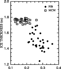
The mean snow depth (±standard deviation) at PIB, 0.27 ± 0.04m, was deeper than that at MCM, 0.18 ± 0.03 m, while the ice at MCM was thicker, 1.76 ±0.02m, than the ice at PIB, 1.49 ±0.10m (Table 1). Generally, thick snow was found covering thin ice and vice versa (Fig. 2). The variability of snow depths between the two sites was similar (Table 1).

Figure 2 Scatter plot of snow depth Vs ice thickness at MCM and PIB.
Table 1. A summary of mean and standard deviation for snow depth, ice thickness, temperature, salinity and percentage of ice type for MCM and PIB. Numbers in parentheses are the number of measurements

Ice-thickness measurements from McMurdo Sound made in previous years, at approximately the same time of year as this study, had similar values. Reference Jeffries and WeeksJeffries and Weeks (1991a) reported a mean ice thickness of 1.94 m and Reference Leventer, Dunbar, Allen and WayperLeventer and others (1987) measured fast-ice thicknesses ranging from 1.5 to 2.0 m. No previous ice-thickness data are available from Pine Island Bay. Although the ice there was thinner than it was in McMurdo Sound, this may have been a result of the difference in sampling dates, with PIB measurements made nearly 2 months after those at MCM, allowing for greater basal melt of the ice at PIB prior to sampling. Ice-thickness measurements were more variable at PIB than at MCM (Table 1)
Salinity
The MCM samples had a slightly higher mean salinity (5.3 ± 0.8‰0) than those from PIB (5.0 ± 2.2‰) (Table I). Previous studies during the austral summer reported mean salinities from McMurdo Sound fast ice of 4.21‰ (Reference Jeffries and WeeksJeffries and Weeks (1991a)) and mean pack-ice salinities from the western Ross Sea of 4.5‰ (Reference Jeffries and WeeksJeffries and Weeks, 1991b), both of which are lower than the 5.3‰ measured during this field season. Individual cores from McMurdo Sound fast ice, however, had mean salinities with a range between 2.95 and 5.39‰ (Reference Jeffries and WeeksJeffries and Weeks, 1991b), which spans the present results. Reference Gow, Ackley, Weeks and GovoniGow and others (1982) calculated an overall mean salinity of 6‰ from first-year ice samples in McMurdo Sound during October and November, while a mean salinity of 4.6‰ with a range between 1.9 ± 1.0 and 6.4 ± 2.0‰ was obtained from Weddell Sea samples obtained in February and March.
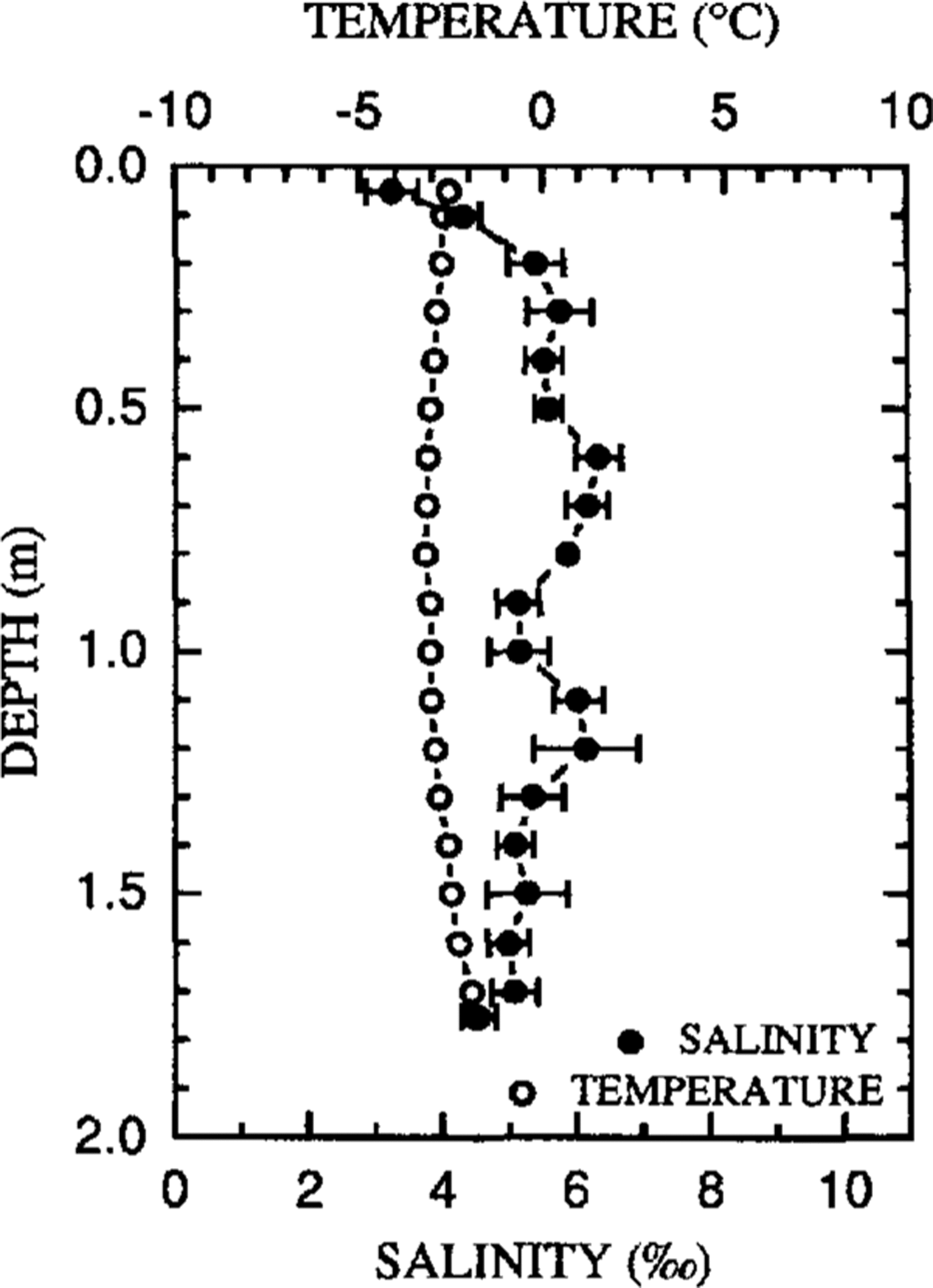
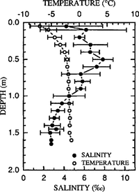
Composite salinity profiles from MCM and PIB are considerably different (Figs 3 and 4). In the MCM cores, a minimum salinity at the surface increases in value down to 0.3 m, whereupon it remains fairly constant with depth with only minor fluctuations to the base of the core. On the other hand, salinity values at PIB have a moderate surface salinity and a strong sub-surface maximum at 0.5 m; from there, salinity decreases significantly with depth to the base of the core. Salinity values within the PIB cores show greater variations, both vertically and horizontally, than those within the MCM cores(Figs 3 and Figs 4 ) with salinity measurements ranging from 2.60 to 6.95‰ at MCM and from 0.75 to 12.3‰ at PIB.


Fig. 4. Temperature and salinity profiles at PIB.
Temperature
The overall mean ice temperature at MCM (–2.8 ± 0.38°C) was the same as that at PIB (-2.8 ± 1.74°C), yet PIB temperatures showed a much greater variation (Table 1). While individual MCM temperatures ranged from -3.3° to -1.9°C, PIB temperatures had a much wirier range, between -9.4° and -1.4°C. The ice sampled from McMurdo Sound is typical of annual summer ice in the Ross Sea, which is identified by warm, nearly isothermal temperatures (Reference PaigePaige, 1966; Reference Jeffries and WeeksJeffries and Weeks, 1991a, Reference Jeffries and Weeks1991b; Reference Danielson and JeffriesDanielson and Jeffries, 1992). Additional cores drilled during this cruise from pack ice in the Amundsen and Bellingshausen Seas have temperature profiles similar to MCM with mean temperatures which range from –2.2° to –0.2°C and show little variation with depth.
The composite core profiles illustrate the significant difference between the thermal characteristics of the ice at MCM and PIB (Figs 3 and Figs 4). The MCM profile displays a slight C-shaped curve with maximum temperatures of –2.6°C near the surface and –1.9°C at the base of the ice and a minimum of -3.1°C at a depth of 1.0 m. Both horizontal as well as vertical variations in temperature are small and the composite profile appears nearly isothermal. On the other hand, PIB temperatures increase from –7.1° to –2.6°C between the surface and 0.5 m depth, and remain nearly isothermal with only a moderate increase to –1.7°C near the base of the ice. Ice temperatures near the top of the core show the most significant horizontal variations, while ice temperatures near the base change very little over distance.
Stratigraphy
Stratigraphic profiles reveal large differences in crystal structure between the two sites (Fig. 5). The ice sheet at MCM is predominantly a two-layered medium with an upper layer consisting of congelation ice and a lower layer of platelet ice. At the boundary between the two layers, there is a transition zone composed of a mixture of congelation and platelet ice (Reference Jeffries and WeeksJeffries and Weeks, 1991a,Reference Jeffries and Weeks1993; Reference Jeffries, Weeks, Shaw and MorrisJeffries and others, 1993). Mean percentage composition of each ice type for each core was calculated by dividing the total length of each ice type by the total length of each core; individual core values were then averaged for mean site composition. At the time of sampling, MCM cores were composed of 54.4 ± 4.8% congelation ice, 38.8 ± 2.4% platelet ice and 6.8 ± 3.0% transition ice, and showed little variation between cores (Table 1). This structure-stratigraphy is similar to previous findings from McMurdo Sound (Reference Jeffries and WeeksJeffries and Weeks, 1991a; Reference Jeffries, Weeks, Shaw and MorrisJeffries and others, 1993)

Fig .5. Stratigraphy diagrams from MCM and PIB showing the variations in crystal structure
PIB cores were composed mainly of frazil ice (79 ± 7.8%) with interspersed layers of congelation ice (16.0 ± 9.2%) at depth (Table 1; Figure 5). Shallow layers of snow-ice at the upper surface of the cores in PIB 2–5 (2.4 ± 0.8%) and a layer of platelet ice at depth in PIB were also present. In addition, there were two voids at depth in cores PIB 2 and 3, which were determined by the distance: the barrel of the ice core dropped through the ice during coring.Ice types and their relative locations within the ice sheet vary considerably between the cores from P1B. unlike those from MCM.
Tipped congelation-ice layers and large amounts of frazil ice in the PIB cores suggest a turbulent environment during ice formation. These characteristics contrast with the consistent bi-layer structure and the regular, downward growth and vertical, columnar texture of congelation crystals in the MCM cores. The large amounts of frazil ice, evidence of deformation events and multiple-ice types in the PIB cores, are similar in stratigraphic composition to cores obtained in the Amundsen and Bellingshausen Seas pack ice during the 1992 cruise (Reference Jeffries, Shaw, Morris, Veazey and KrouseJeffries and others, 1994b), which consisted mainly of frazil ice and numerous features indicative of deformation. These differences illustrate the wide range of physical conditions affecting the growth environment of sea ice around the Antarctic continent.
Crystal Sub-Structure
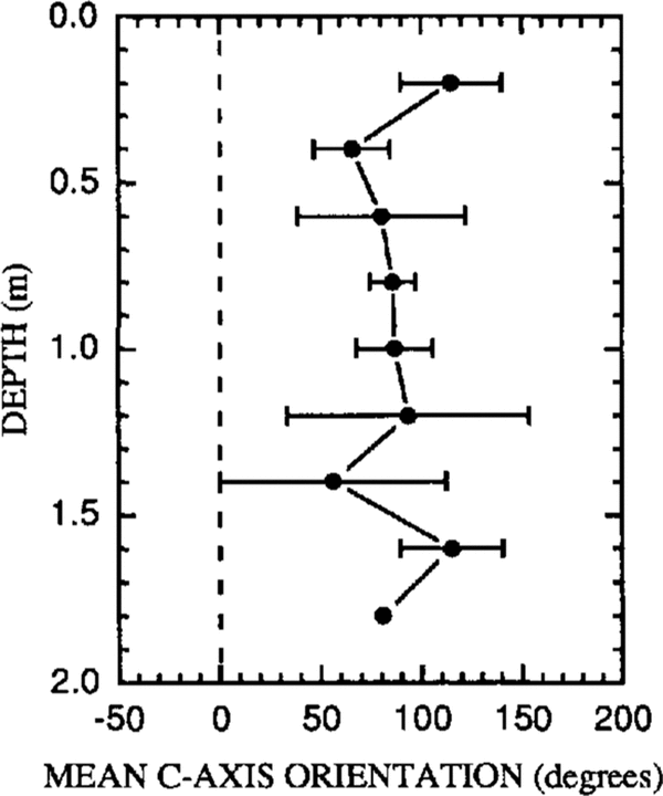
Crystal sub-structure measurements of c-axis orientation and plate width were performed on MCM congelation-ice crystals at 0.2 m intervals (Fig. 6). c-axis orientation shifted from 115 ± 25° to 66 ± 19° between depths of 0.2 and 0.4 m. Between 0.4 and 1.0 m, the orientation remained fairly constant, ranging from 66 ± 19° to 87 ± 19°. The roughly east-west orientation is close to values obtained by Reference Gow, Ackley, Weeks and GovoniGow and others (1982) in approximately the same location. Measurements at 1.2 and 1.4 m showed the largest variations with mean values of 93 ± 60° and 56 ± 56°, respectively. These values occur where platelet ice begins to dominate the stratigraphic profiles (Fig. 5.). Below 1.0 m, c-axis orientation changes rapidly with each successive depth interval.

Fig .6. Mean c-axis orientation profile from MCM.
c-axis orientation standard-deviation (so) profiles for each core (Fig. 7) show standard deviations ranging from 13° to 67°. Similar values were reported by Reference Jeffries, Weeks, Shaw and MorrisJeffries and Weeks (1993) in the western Ross Sea and by Reference Weeks and GowWeeks and Gow (1978, Reference Weeks and Gow1980) along the northern coast of Alaska. Crystal alignment, strongest at 1.0 m as illustrated by the low S0 values, decreases from 1.0 m toward both the surface and the basc of the ice. Previous studies by Reference Jeffries and WeeksJeffries and Weeks (1993) and Reference Jeffries, Weeks, Shaw and MorrisJeffries and others (1993) present a similar range of s0 values, but the profiles varied from site to site and do not display the roughly C-shaped curve apparent in these data.

Fig. 7. Profile of the variations in congelation ice So values (c-axis standard deviation) for sites MCM 1-5.
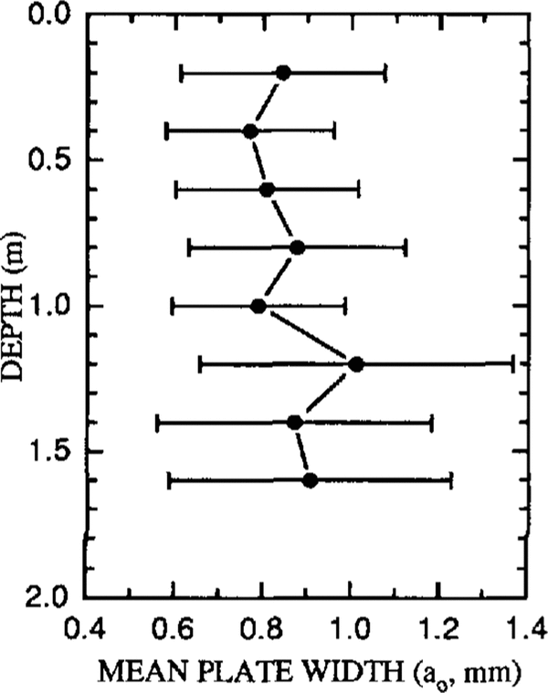
The mean plate width (a0) of the congelation icc at MCM varied between 0.84 ± 0.23 and 1.01 ± 0.36 mm, slightly higher than the range (0.49 0.99 mm) reported by Reference Jeffries, Weeks, Shaw and MorrisJeffries and others (1993). There is a general trend toward increasing plate width from the surface down to 1.2m with a0 increasing from 0.84 ± 0.23 to 1.01 ± 0.36 mm (Fig. 8.). Below 1.0 m are the crystals with the largest plates and they show more variation at each depth than those in the upper 1.2 m of the core. The MCM profile, with its somewhat irregular variations in a0 with depth, is similar to the a0 profile given by Reference Jeffries, Weeks, Shaw and MorrisJeffries and others (1993) and contrasts with the steadily increasing a0 values reported in Reference PaigePaige (1966).

Fig.1. Profile of mean plate widths (a0) at MCM.
Discussion
The stratigraphy and physical properties (excluding snow depth) measured at PIB showed a significantly higher degree of variability between cores than those at MGM. The stratigraphic profiles from PIB suggest that the ice was formed in a turbulent environment and are indicative of high wind and wave action which cause frazil-ice generation, rafting and ridging events, and perhaps flooding of the snow on the ice surface, creating Snow-ice. While the voids in the ice might indicate brine drainage prior to sampling, they might also reflect deformation events. For instance, winter storms could create jumbled piles of rafted ice with interstitial air pockets which remain unfrozen as voids within the ice cover. The PIB profiles differ from core to core, regardless of core spacing. Although these cores were drilled from fast ice in Pine Island Bay, their exact origin is uncertain. While the ice may have grown in the bay during heavy winter storms, the possibility exists that the ice originated further offshore and was subsequently blown into the bay where it was consolidated as fast ice.
The temperature profiles from the ice at PIB reflect a cold atmospheric environment. Reduced brightness temperatures in passive-microwave images from Pine Island Glacier (Reference Zwally, Comiso, Parkinson, Campbell, Carsey and GloersenZwally and others, 1983) may be evidence of cold, katabatic winds which would cool the ambient air and upper layers of the sea ice in Pine Island Bay. The horizontal variation in temperatures near the ice surface may be a result of fluctuating air temperatures and/or differences in the amount of snow acting as insulation from core to core. Cold air temperatures could explain the high-salinity values in the upper 0.5 m, since brine drainage would be minimal. The heat flux from the ocean has warmed the ice below 0.5 m, resulting in significant brine drainage and lower salinities. The horizontal variations in the upper 0.2 m salinity values are most likely a result of snow-ice formation which would lead to lower and more variable salinity values depending on the proportions of snow and sea water in the ice.
Small-scale horizontal and vertical variations between cores at MCM were less significant than those at PIB. The two-layer stratigraphic profile defined by congelation ice overlying platelet ice has been a well-known feature of McMurdo Sound sea ice for the past three decades (Reference PaigePaige, 1966; Reference Gow, Ackley, Weeks and GovoniGow and others, 1982; Reference Lewis, Perkin and JacobsLewis and Perkin, 1985; Reference Crocker and WadhamsCrocker and Wadhams, 1989; Reference Jeffries and WeeksJeffries and Weeks, 1991a; Reference Jeffries, Weeks, Shaw and MorrisJeffries and others, 1993). Stable congelation-ice growth generally begins in McMurdo Sound in April and is supplemented by later platelet-ice accretion on to the bottom layer of the congelation-ice sheet. Ice thickness at MCM may be greater than that at PIB as a result of platelet-ice growth, less snow during the winter ice-growth period, or the earlier sampling date, and resultant minimal basal melt at MCM. Platelet ice is thought to form as low-density water flows northward from under the Ross lee Shelf, becomes supercooled through adiabatic decompression, and accretes on to the base of the sea-ice sheet in the form of large angular platelet-ice crystals (Reference Lewis, Perkin and JacobsLewis and Perkin 1985; Reference Crocker and WadhamsCrocker and Wadhams, 1989). The platelet crystals are consolidated by interstitial congelation-ice growth (Reference Jeffries, Weeks, Shaw and MorrisJeffries and others, 1993). While some previous melt had probably occurred at the base of the ice sheet, the uniformity of the MCM stratigraphic profiles suggests that the formation of the platelet ice begins at approximately the same time over the range of the transect.
The warmer air temperatures of McMurdo Sound, as compared to Pine Island Bay, are evident in the warm surface temperatures of the MCM cores. The small horizontal variation in temperature suggests that similar processes are occurring over distances spanned by the 30 m transect at MCM. While a significant amount of brine drainage had occurred prior to sampling, the mean salinities of both sites are still well above the mean salinity of 3‰ reported for Arctic ice of similar thickness (Reference Cox and WeeksCox and Weeks, 1974). Horizontal variations in salinity values at MCM are minimal when compared to those of the PIB cores. In addition, the standard deviation of 0.8‰ in the salinity profiles at MCM was similar to previous results in the Arctic (Reference Weeks and LeeWeeks and Lee, 1962; Reference Lake and LewisLake and Lewis, 1970; Reference Tucker, Gow and RichterTucker and others, 1984), but the standard deviation of 2.2‰ at PIB was significantly greater than previous studies. These findings again lead to the conclusion that, while similar growth and decay events may be occurring across the 30 m transect at MCM, processes at PIB may be significantly different across the sampling transect.
Previous research on c-axis orientations has confirmed that water currents can control the alignment of the crystals as they are formed at the ice—sea-water interface (Reference Weeks and GowWeeks and Gow, 1978; Reference LanghorneLanghorne, 1983; Reference Nakawo and SinhaNakawo and Sinha, 1984; Reference Langhorne and RobinsonLanghorne and Robinson, 1986). The congelation ice in the upper layers of the MCM cores supports findings by Reference Gow, Ackley, Weeks and GovoniGow and others (1982) that the current direction is generally east-west off the southwestern tip of Hut Point Peninsula. As a function of depth, c-axis orientation variations in the upper 1.0 m of the cores suggests that the current direction can change over time. Variations below 1.0 m may be a result of the effect of loose conglomerations of platelet-ice crystals creating a slower and more chaotic flow of water at the ice—water interface. The general trend of increasing ao values with depth in the upper 1.0 m may be attributed to a decrease in the growth rate with depth, as explained by Reference Lofgren and WeeksLofgren and Weeks (1969) and Reference Nakawo and SinhaNakawo and Sinha (1984) The largest horizontal variations in ao, found near the base of the cores, are probably due to the effects of platelet ice on water flow. At some locations, the platelet ice appears to enhance the flow rate in the favored direction of crystal growth, parallel to the current direction (Reference Nakawo and SinhaNakawo and Sinha, 1984; Reference Langhorne and RobinsonLanghorne and Robinson, 1986), therefore increasing the value of a0, while in other locations the flow seems to inhibit maximum growth and serves to decrease ao.
Conclusion
The small-scale physical properties and structural— stratigraphic characteristics of five pairs of cores obtained from one site in the fast ice in McMurdo Sound were examined and the results were compared to previous studies. In addition, the first ice samples to be obtained from Pine Island Bay were characterized and compared to the McMurdo Sound cores and previous sea-ice research. Relatively cold annual air temperatures at PIB may prevent significant amounts of brine drainage, resulting in large vertical variations in temperature and salinity with cold, saline upper layers and warm less-saline lower layers. Turbulent conditions during icc growth, perhaps the result of severe winter storms in the Pine Island Bay region, may lead to the non-uniform stratigraphy profiles characterized by large amounts of frazil ice and layers of tipped congelation ice. Warmer summer air temperatures at MCM create conditions which enhance brine drainage and result in salinity and temperature profiles that vary little with depth. Initial calm ice-growth conditions result in an upper congelation-ice layer, while supercooled water flowing out from the Ross lce Shelf forms large, angular ice crystals which accrete on to the base of the icc sheet, forming a lower layer of platelet ice, Due to the different physical environments of McMurdo Sound and Pine Island Bay, sea-icc characteristics differ betwen the sites and are more variable along the transect at PIB than MCM.
Acknowledgements
This work was supported by U.S. National Science Foundation grant DPP-8915863. We received technical support and assistance from the officers and crew of the icebreaker USCGC Polar Sea and the U.S. Coast Guard aviation department.