


Introduction
The piedmont of the Maloti-Drakensberg lies between the high mountains of the same name in South Africa and Lesotho, and the edge of the Great Escarpment in the Eastern Cape Province, South Africa (Figures 1–2). ‘Project Piedemonte’ investigates the prehistory and historical use of the piedmont, with an emphasis on its peculiar geography and environmental conditions.

Figure 1. A) location of the study area; B) digital terrain model of the study area (figure by F. Colino).

Figure 2. A–D) landscape views in the Stormberg area; E) stone fence posts (probably late 1800s) alongside a modern fence; F) remains of a dwelling, possibly mid to late 1800s; G) part of the fortifications of a British outpost dating to the Anglo-Boer War (1899–1902); H) part of a protective shelter built by the Boers during the Battle of Labuschagne's Nek in 1901 (photographs by P. de la Peña & B. Maclennan).
Our study area lies within the grassland biome characterised by a cold, dry climate, summer rainfall and winter drought. It is bounded to the north by the Kraai River Basin and to the south by the Kei River Basin. ‘Project Piedemonte’ focuses on the movement of communities between the low-lying grassland biome and the colder and drier AfroAlpine biome at the higher altitude (>1800m) of the Maloti-Drakensberg range.
There is a dearth of previous research on the archaeology and rock art of the study area (Lee & Woodhouse Reference Lee and Woodhouse1970; Opperman Reference Opperman1987; Collins et al. Reference Collins, Wilkins and Ames2017). Investigation of the piedmont in this part of southern Africa offers the opportunity to explore three important issues. The first is the use of landscape; the piedmont is situated in the grassland biome, which has seen little research into its Middle Stone Age levels. Second, the piedmont borders on, and partially overlaps, regions that have long been the focus of research investigating Later Stone Age seasonal mobility and landscape exploitation (Carter Reference Carter1970; Opperman Reference Opperman1987; Mitchell Reference Mitchell1992). We seek to augment this research with data from our study area. Third, the rich depositional sequences in the piedmont, which represent a long period encompassing the Middle Stone Age, the Later Stone Age, contact between Later Stone Age hunter-gatherers and pre-colonial livestock-keeping communities, and colonial and historic times, allow detailed investigations of interactions, occupations, continuity and change over time. Intensively researched neighbouring regions (particularly to the north, south and east) that abut the study area (Mitchell Reference Mitchell2009) offer opportunities for comparison. Through these comparisons, archaeological sites in the piedmont—which has traditionally received little attention from archaeologists—have the potential to contribute to current understandings of interactions between hunter-gatherers, herders or pastoralists, and agro-pastoralists (as well as more recent colonists and cattle-raiders) over the last 2000 years.
Objectives and theoretical background
The primary objective of ‘Project Piedemonte’ is to investigate altitudinal movement of people between the Maloti-Drakensberg and the plains, and to determine whether occupation of the piedmont changed over time. In particular we will investigate general mobility strategies as well as the seasonal movements of both hunter-gatherers and communities with livestock—whose movements may have been large- (transhumance) or small-scale (transterminance) (Velado Alonso & Gómez Sal Reference Velado Alonso, Sal, Casasús and Lombardi2016: 65). For peoples with livestock, comparative case studies include those developed in the Pyrenees (Gassiot Ballbè et al. Reference Gassiot Ballbè, Rodríguez Antón, Pèlachs Mañosa, Pérez Obiol, Julià Brugués, Bal-Serin and Mazzucco2014), Alps (Walsh et al. Reference Walsh, Mocci and Palet-Martínez2007) and southern Africa (Kinahan Reference Kinahan1994).
The long-term investigations of ‘Project Piedemonte’ will use analyses of raw materials and technology, faunal analyses, geoarchaeology of different excavated sites, and analyses of palaeobotanical remains. In addition, palaeoenvironmental reconstructions for all periods studied will complement the reconstructions of prehistoric and historical mobility patterns. General seasonal movements will be investigated by analysing archaeological fauna (use-wear dental analysis and isotopes). These investigations will be compared to previous research on sites on the Eastern and Western Cape coasts and to sites in the AfroAlpine region of the grassland biome.
A secondary objective of the project is to understand how rock art sites and excavated sites jointly relate to seasonal or transhumance patterns in the piedmont. This is an avenue of investigation that has received little attention. Rock art offers a complementary strand of evidence on Later Stone Age seasonality (e.g. Carter Reference Carter1970; Mazel Reference Mazel1983). Quantitative research along the Maloti-Drakensberg's eastern escarpment revealed that some motifs, such as felines and wildebeest, are depicted rarely in that area (e.g. Vinnicombe Reference Vinnicombe1976; Lewis-Williams Reference Lewis-Williams1981). Although no quantitative research to record motifs has been undertaken in the piedmont, our fieldwork observations suggest far higher frequencies of ‘rare’ motifs in our study area. This could indicate a relationship between the locations of animal-themed paintings and animal migrations in and around the Maloti-Drakensberg.
Our project takes an evolutionary perspective of the past; it does not take for granted particularist periods, but emphasises long processes and human adaptation through time. Our exploration of Middle Stone Age hunter-gatherer mobility patterns is theoretically informed by the work of Kelly (Reference Kelly1983), while enquiries into Later Stone Age rock art draw on studies by Carter (Reference Carter1970) and Mazel (Reference Mazel1983) as well as the interpretative work of Lewis-Williams (Reference Lewis-Williams1981).
Preliminary results
A strategic prospection plan, taking into account factors such as geology, elevation and drainage, located several rockshelters with long depositional sequences in the Stormberg range of the piedmont. Thus far, four types of site have been identified and recorded during two intensive prospection surveys: 1) historical sites; 2) rockshelters with long depositional sequences of prehistoric and historical occupations; 3) open-air Middle Stone Age sites; and 4) rockshelters with rock art (Figures 2–5). Several previously known sites were also mapped, documented photographically and inventoried (Figure 6).

Figure 3. Marshill rockshelter (A–D) exemplifies the long prehistoric and historical record investigated by the project, with Middle and Later Stone Age deposits, as well as rock art and historical remains (photographs by P. de la Peña & D. Witelson).

Figure 4. Open-air sites and stone tools in the Stormberg: A–C) Middle Stone Age artefacts eroding out of an alluvial fan; D–F) Middle Stone Age workshop and artefacts on a tributary of the Wolwespruit (photographs by P. de la Peña).

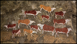
Figure 5. Rock art in the Stormberg: A) digital photograph and enhancement of two women with weighted digging sticks; B) well-preserved images of an eland; C) digital photograph and enhancement of an elongated anthropomorphic figure with human head and arms; D) a yellow painting of a feline; E) digital photograph and DStretch enhancement (YRE) of a therianthrope (part human, part animal being) with human body and animal hooves; F) black and white photograph of cattle accompanied by human figures with spears (all images by D. Witelson).

Figure 6. Map showing preliminary survey results (figure by D. Witelson).
Future research
Excavation of the largest rockshelter located during the prospection survey is planned with a view to integrating the various excavated and parietal deposits (Figure 3). This site is significant because of its long depositional sequence, which probably spans the Middle Stone Age through to the historical period. The site preserves rock art that appears, by virtue of its subject matter, to relate to the Later Stone Age, contact, and colonial periods.
Acknowledgements
We wish to thank Fernando Colino, Ben Maclennan, Gillian Warren-Brown and Nellie and Hannie van Heerden. The Centre of Excellence in Palaeosciences and the NRF Y-rating fund have provided valuable funding to P. de la Peña. D. Witelson expresses his gratitude to Susan Ward for her financial support.


