


Introduction
Traditionally, Snow-Patches have been distinguished from glaciers by identification of the former as static and the latter as mobile. Evidence of snow-pack mobility (Reference CostinCostin and others, 1973; Reference Mathews and MackayMathews and Mackay, 1975) obscures the established glaciological distinction. A parallel problem exists in separating the geomorphic impact of snow-patches and glaciers. In many ways “nivation” (a collective noun used to summarize all snow-pack-derived erósion) confounds the issue.
Reference MatthesMatthes (1900) coined the term “nivation” after a reconnaissance study in the Big Horn Mountains of Wyoming, U.S.A. Unfortunately, the term became entrenched in the literature prior to any comprehensive process studies designed to identify individual components and their relative importance. That nivation remains a rather loose concept and lacks a uniform definition is shown by the literature review summarized in Table I.
Table I. Elements of nivation according to most widely cited references

Faced with such an amorphous concept, two recent and independent studies (Hall, unpublished; Reference ThornThorn, 1976, unpublished) have attempted to verify quantitatively the existence and characteristics of nivation. This paper is a post hoc comparison of the two studies and provides a comparison between nivation in arctic maritime (Hall, unpublished) and temperate alpine regimes (Reference ThornThorn, 1976, unpublished). The individual findings and methodologies of the two studies are not discussed exhaustively, rather the emphasis is upon the comparisons and contrasts and their significance for refining the understanding of nivation.
Study sites
Arctic site
The Arctic site lies on a north-facing slope of the east–west trending valley of Austre Okstinbredal in the Okstindan region of northern Norway (Fig. 1). The north-facing valley wall rises from 725 m, through a series of benches, to a maximum elevation of 1916 m a.s.l. only 80 km from the sea, the area is relatively maritime; integration of a partial local climatic record with data from Hattsfjelldal, some 50 km south, suggests a mean annual temperature of approximately –3°C. Mean annual precipitation is 1120 mm and snow covers the ground for 180 d of the year.
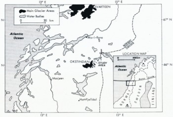
Fig. 1. Regional location of the Arctic research site. The map is modified with permission from The Times atlas of the world. Mid-century edition. Vol. 3. Northern Europe. London, The Times Publishing Co., Ltd., 1955, plate 52.
The study site lies mainly at 800 m a.s.l. Overall the semi-permanent snow-patch comprises an upper transverse section and a longitudinal section which drops to the valley bottom (Fig. 2). The transverse section has a maximum width across slope of 150 m, and a maximum down-slope extent of 100 m; The longitudinal section is only 20–30 in wide, but nearly 250 m in length. Only the transverse snow-patch was studied in detail.

Fig. 2. A view looking approximately south-west across the Arctic research site. Note the waterfall at the top of the transverse section of the snow-patch.
Four small-scale elements may be identified within the transverse patch. These are: (1) a near-vertical bedrock back-wall; (2) a stone pavement dissected by rock outcrops, parlicularly well developed at the eastern end; (3) a lower vegetated area; (4) a gully which bisects the entire site (the gully is headed at the back-wall by a waterfall, and below the transverse snow-patch becomes the location of the longitudinal snow-patch). The back-wall ranges from 2–10 m high and averages about 4 m; it is composed of various types of schist and basal niches are prominent. Coarse gravel and cobbles in a matrix of fines forms the stone pavement which is unvegetated and dissected at its eastern end by a series of bedrock outcrops (“rockbands”) up to 1.5 m high and parallel to the slope. Vegetation gradually increases down-slope, culminating in a continuous cover, dominated by billberry (Vaccinium myrtillus), dwarf birch (Betula nana) and Carex spp.
Alpine sites
Two snow-patches on the south face of Niwot Ridge, Colorado Front Range, U.S.A. (Fig. 3) Were the focus of the alpine study. The bedrock, or “longitudinal”, snow-patch (Fig. 4) is approximately 3590 m a.s.l. It is a seasonal snow-patch which accumulates to depths of 4–5 m against the western wall of a narrow gully dissecting a cliff. The bedrock is gneiss and at the up-slope end of the gully there is evidence of hydrothermal alteration (Thorn, unpublished).

Fig. 3. Location of the three alpine research sites. The longitudinal site is the source of bedrock data; Martinelli site is the primary colluvial site; Saddle site is the subsidiary colluvial site briefly mentioned in the text. Contour interval is approximately 61 m.

Fig. 4. Looking north-west across the longitudinal site. The early June 1973 photograph shows the snow-patch near its maximum extent against the wall. The large snow-free buttress to the right of the person served as the control site.
The larger (“Martinelli”) snow-patch (Fig. 5) ranges through the tundra-forest ecotone at elevations above 3450 m a.s.l. Maximum extent is approximately 175 m across slope and 450 m down-slope. Syenite colluvium underlies the snow patch which accumulates along the down-wind edge of a till lobe. As the ablation season progresses the snow-patch divides into an upper, circular snow patch and a lower, longitudinal one; the upper patch rarely ablates totally, but the lower patch is destroyed annually.

Fig. 5. Looking north-east across Martinelli snow-patch (the alpine colluvial site). Photograph shows subdivision into upper and lower basins during melt-out.
Core areas of both martinelli patches are unvegetated, but peripheral areas are partially vegetated and discontinuous tundra cover occurs beyond the upper basin and sub-alpine meadow beyond the lower basin.
Mean annual air temperature on the crest of Niwot Ridge is – 4°C with annual precipitation of 1021 mm (Reference BarryBarry, 1973). Wintertime wind speeds are high; mean monthly averages from October through March exceed 11 m/s. As a result the landscape is divided into zones of high and low effective precipitation, as snow-fall is rapidly redistributed.
Methodologies
The two methodologies contain fundamental similarities while differing substantially in detail. Comprehensive methodological descriptions are provided in Hall (unpublished) and Thorn (unpublished); the discussion herein is restricted to essentials.
Both studies attempted to verify nivation by testing the research hypotheses that nivation promotes: (i) mechanical weathering, (2) mass wasting, (3) chemical weathering. Each hypothesis was investigated by monitoring individual geomorphic processes. A fundamental component in the research design for the alpine program was that all measures were comparative. Each snow-patch measurement was matched by identical measurements at adjacent snow-free locations. This approach was intended to recognize nivation as a concept of intensification, rather than one of unique properties.
In both studies a bedrock freeze-thaw cycle (a purely thermal event) was accepted as a surrogate measure for a geomorphologically effective freeze-thaw cycle. In reality, there are important distinctions between the two as the latter is normally considered to be subject to important moisture constraints, in addition many researchers also envisage important freezing-intensity and/or freezing-duration constraints. However, it is not presently possible to monitor bedrock moisture content remotely, and therefore moisture conditions must be inferred.
At the Arctic site, multichannel recorders, with 2 h and 6 h sampling intervals, were attached to thermistors cemented to the bedrock face in a variety of micro-environments. The multichannel recorder at the alpine bedrock site produced spot readings at two-hourly intervals from thermistors inserted into holes drilled into the bedrock to depths of 10, 20, 30, and 50 mm (only those at 10 mm are discussed in this paper). Both records are discussed in terms of Reference HewittHewitt’s (1968) terminology which describes a freeze-thaw cycle and its component parts as a wave form.
Mass wasting at snow-patch sites would appear to be dominated by solifluction, overland flow, and frost creep (Hall, unpublished; Thorn, unpublished). A variety of other processes are possible, or probable, but do not appear to be quantitatively important. Amongst these are the snow-dependent processes of sub-snow creep, produced by a mobile snow-pack, and supra-snow movement, resulting from material free-falling and then rolling or sliding, or being included in surface avalanches.
At Martinelli snow-patch, overland flow was comprehensively monitored using small sediment traps (Reference ThornThorn, 1976). These traps, with a catching edge of 100 mm, were distributed in groups of five and left at the site during the winter. Direct measurement of solifluction was not undertaken at martinelli snow patch. A combination of Rudberg Pillars and Polythene tubes was used to monitor solifluction at austre okstinbredal. The hollow tubes bent with down-slope movement. Deflection was measured by inserting test tubes filled with warm jello which was allowed to cool and harden; upon removal, the angle between the jello surface and the horizontal may be used to calculate down-slope deflection. An incremental approach permits reconstruction of vertical profiles (Hall, unpublished, p. 237–46).
Both studies investigated chemical weathering by chemical analysis of snow and melt-water solutes. Arctic samples were subject to analysis by atomic absorption spectrometer; alpine samples to analysis by colorimeter. In addition, rock samples from the Arctic were examined microscopically for signs of chemical weathering, while the spatial variation in weathering-rind thickness was mapped at Martinelli snow-patch (Reference ThornThorn, 1975.)
Mechanical weathering
A geomorphically effective freeze-thaw cycle, that is one which disrupts bedrock, is still an uncertain concept. This is because the precise nature of the disruptive forces remains undetermined (see Hall, unpublished, andReference Thorn Thorn, 1979, for discussions). Most laboratory experiments have consisted of freezing rocks to varying degrees, then thawing them and noting the degree of breakdown, without investigating the mechanics of the breakdown process(es). All laboratory researchers (e.g. Reference FukudaFukuda, 1972; Reference PottsPotts, 1970; Reference LatridouLatridou, 1971) identify rock saturation as a prerequisite, but the necessary freeze-phase amplitude remains uncertain. Reference PottsPotts (1970) favors the frequency with which 0°C is crossed, regardless of intensity, as the controlling factor. Most other researchers cite a specific freezing amplitude: Reference FukudaFukuda (1971), –4°C; Reference FukudaFukuda (1972), –5°C; Reference Dunn and HudecDunn and Hudec (1966), –6 to –10°C. Reference LatridouLatridou (1971), summarizing the results of many workers at Caen, suggests both an amplitude of –5°C and a duration of at least 9–10 h. Finally, Reference Battle and LewisBattle (1960) and Reference MellorMellor (1973) emphasize freezing-rate, Battle stating that a minimum cooling-rate of 0.1 deg/min–1 is necessary.
In part this variability reflects uncertainty as to the exact process of disruption. Principal possibilities are pressure due to direct expansion upon freezing (Reference MellorMellor, 1973), oriented ice-crystal growth (Reference Connell and TombsConnell and Tombs, 1971), and the growth of macroscopic crystals in large pore spaces (Reference EverettEverett, 1961). The thermodynamics of the situation is only known in very general terms (Reference EverettEverett, 1961). Reference Hudec, Aitken and GlassHudec ([1973]) has produced a series of papers which provide substantial evidence that in the majority of instances freeze-thaw weathering is, in reality, weathering by wetting and drying. Domination by one process or the other is primarily dependent upon pore size and its distribution within the bedrock. The critical problem is that in the most widely cited geomorphic literature on freeze-thaw weathering the experimental designs do not permit separation of the two weathering processes.
Data
Only the fall freeze and spring melt periods may be compared; even these must be evaluated in general terms as data are for different years, and of uncertain representativeness.
The clearest contrasts between the two bedrock sites during freeze-up appear to be the higher frequency of low-amplitude cycles at the alpine accumulation site, and the greater freeze amplitude of the late freeze-up cycles in the Arctic (Tables II and III). The former must be viewed cautiously as it is certainly in part a reflection of sampling interval (two hours in the alpine versus six hours in the Arctic). High inter-annual variations in seasonal frequency at alpine accumulation sites (thermistor 19, Table IV) reflect the difference between a dry fall with late establishment of the winter snow-pack (1971) and one with numerous temporary accumulations (1972).
Table II. Fall and early-winter freeze-phase amplitudes at the arctic site (rockband 6), 13 September-9 December I973

Table III. Fall and early-winter freeze-phase amplitudes at alpine microsites, 1971*

Snow-free alpine sites experience wintertime freeze-phase amplitudes equal to, or exceeding, Arctic fall cycles. This is not generally true of snow-buried sites, where insulation precludes such freezing amplitudes; however, April 1972 was one of record cold, and even snow-buried sites had temperatures as low as – 20°C, although without the intervening thaw phases which produce complete cycles.
Comparison of melt-out periods reveals a contrast between the two regimes. In the Arctic, sub-snow temperatures remained just below freezing, upon melt-out bedrock temperatures rose quickly without recording freeze-thaw cycles. Sub-snow bedrock temperatures in the alpine situation exhibited as many as sixty low-amplitude cycles (freeze-phase amplitude
Individually, the alpine record illustrates the insulating role of the snow-pack which, thereby, redistributes the seasonal pattern of cycle occurrence (Table IV). A further facet is that high-amplitude freeze phases are also precluded at snow-pack accumulation sites.
Table IV. Seasonal distribution of freeze–thaw cycle frequency at the alpine bedrock site

Analysis
Evaluation of the relative potential for freeze-thaw weathering at the two sites is dependent upon the thermal criterion selected (accepting the additional critical factors of bedrock porosity and adequate rock-moisture content). If simple oscillations across O°C, without regard to freezing amplitude, are effective, then clearly the alpine environment is more vigorous. It would also appear to have a strong seasonal rhythm, with a principal springtime maximum, and a secondary fall peak, which is particularly well developed during falls with frequent, temporary snow-pack accumulations.
Selection of any of the cited freezing amplitude criteria appears to come close to eliminating freeze-thaw weathering at the alpine site (Table V). The snow-patch probably supplies the necessary moisture, but snow-pack insulation precludes high freeze-amplitude cycles. Conversely, snow-free sites experience adequate freeze-phase amplitudes, but would seem likely to lack adequate moisture. Thus, the Arctic would be a more effective freeze–thaw weathering regime climatically. Furthermore, the season of optimal conditions shifts from the spring to the fall and early winter. This rather simple contrast is probably subject to substantial modification.
Table V. Seasonal distribution of freeze-thaw cycle-frequency with freeze-phase amplitude ≥ –5.0°C at the alpine bedrock site*

Relationships between a number of factors probably control the location of effective freeze-thaw weathering in both Arctic and alpine regimes. Bedrock porosity is the dominant control, for without suitable porosity either wetting and drying weathering will prevail or rocks will be “sound” (Reference Hudec, Aitken and GlassHudec, [1973]), that is resistant to weathering. Further constraints are imposed by snow-pack distribution in response to prevailing wintertime winds, as without snow melt adequate moisture is unavailable. These are the two fundamenlal controls which create the presence or absence of freeze-thaw cycle weathering; its intensity is modified by additional relationships.
Freeze-thaw weathering intensity in any region would appear to be dependent upon the interplay between freezing amplitude, Snow-pack insulation, and total direct solar radiation; all of which vary seasonally. Snow-pack depths vary the insulation afforded the underlying bedrock; in general, any moderate to deep accumulation will obliterate all diurnal variations and most synoptic fluctuations. Therefore, such sites do not exhibit wintertime cycles; certainly neither site in the present studies did so. Radiation can penetrate snow to a depth of approximately one meter (Reference GeigerGeiger, 1961), so even if cold waves penetrate the snow-pack there is no potential for sub-snow melt once the snow-pack exceeds this depth and residual ground heat has been exhausted. Even if totally sub-zero temperature changes can exert stresses on the rock, they will occur very slowly beneath a snow-pack.
Optimum conditions are likely to be associated with deep accumulation sites in fall and/or spring, and with temporary and/or shallow accumulation sites in winter. In either case a southerly or easterly aspect is likely to maximize the weathering regime. The absence of sub-snow cycles during melt-out at the Arctic site is probably due to its northerly aspect, rather than its latitude; conversely, the easterly aspect of the alpine site undoubtedly maximized the frequency of sub-snow cycles. A further point to appreciate is that optimal conditions of high moisture and low insulation also occur immediately down-slope of melting snow-patch sites.
Widespread association between snow-patches and basal niches, such as at the Arctic site, may possibly depend upon wetting and drying cycles, or salt weathering, rather than upon freeze-thaw weathering. Location of such niches at the base of steep faces locates them in zones of maximum snow-pack accumulation, and therefore of maximum insulation and belated melt-out. Both of these factors tend to minimize high-amplitude freezing frequency. In contrast, such locations experience optimal moisture supply as water percolates downward through the rock. It is even possible that the snow produces a perched water table by maintaining freezing temperatures in the abutting bedrock, thereby directing water along an impervious surface. Given the data herein, such an hypothesis compares favorably with the classic idea that such locations experience optimal freeze-thaw weathering regimes. This latter argument would appear to be valid only if cycle frequency, regardless of freezing amplitude, is dominant.
A final point is that comparative studies at both sites indicate the inadequacy of air-temperature data as an indicator of bedrock freeze-thaw frequency, form, or amplitude. Such features in bedrock tend to be dominated by aspect and snow cover, and only the most generalized relationships can be established between air and bedrock temperatures (Reference ThornThorn, 1979).
Chemical weathering
Traditionally chemical weathering has been assumed to be very low in cold environments. This is based primarily on the assumption that reactions are temperature dependent and therefore slowed in cold regimes. Reference TammTamm (1925) presented evidence that between +2 and + 15°C reaction rates are invariant. Furthermore, Reference Reynolds and JohnsonReynolds and Johnson (1972) propose that water and hydrogen-ion supply, not temperature, are the limiting factors. Most researchers appear to have accepted the temperature-dependency hypothesis and consequently chemical activity has received relatively little attention. Just how misleading this may be was clearly established by Reference RappRapp (1960) when he found that in Kärkevagge, Swedish Lappland, solute load was the foremost denudational process.
Data
Snow pH measurements at both sites fell into the range 4.5–5.5, which is a normal measurement for snow (Reference Clement, Vaudour, Wright and OsburnClement and Vadour, 1968). Comparisons of snow solute concentrations with those in melt waters are given in Table VI (Arctic) and Table VII (alpine). It should be noted that the alpine data are for the colluvial site. Despite the absence of overlap in measures, the data produce a unified picture of rapid solution, but of moderate intensity. Sodium at the Arctic site is assumed to be wholely atmospheric and to result from proximity to the sea. Clearly the high calcium values in melt waters indicate weathering of the calc-schists and impure marbles which outcrop at the site. the three alpine melt-water sites exhibit a trend of increasing solute load with increasing distance travelled underground. This statement, however, is based on careful surficial examination and not upon tracer studies (Thorn, unpublished).
Table VI. Solutes (p.p.m.) from precipitation, snow-pack, and melt waters at the Arctic site

Table VII. Solutes (p.p.m.) from snow-pack and melt waters at the alpine colluvial site

Microscopic examination of thin sections from Arctic bedrock samples showed staining indicative of chemical weathering. Furthermore, surface staining was widely evident in the field. A comprehensive mapping of weathering rind thickness on surficial debris was undertaken at the alpine colluvial site (Reference ThornThorn, 1975). It revealed a distinct hiatus between the nearby snow-free control site and the snow-patch. Rinds were two to three times thicker within the confines of the nivation hollow, and showed distinct peaks in zones where melt-water concentration was apparent.
Analysis
Overall data suggest that snow-patch sites exhibit high regional relative rates of chemical weathering, although these may be low by absolute world-wide standards. On a priori grounds melt waters are likely to be inefficient in comparison to rainfall. Snow-fall is concentrated in a chemically inert state (there being no geomorphic equivalents to sheet-wash and through-flow during concentration of the snow-pack), and then released over a small portion of the landscape. This simple reduction in water-ground surface-area contact is probably the major contributor to reduced chemical weathering-rates. Certainly ground-surface temperatures quickly enter Tamm’s (1924) +2 to +15°C range after melt-out.
A final point is consideration of the relative importance of mechanical and chemical denudation. A ratio of approximately one to one was determined at the alpine colluvial site, which suggests that while chemical rates may be low in absolute terms, it is possible that mechanical rates have traditionally been overestimated.
Mass wasting
Traditionally, the mass-wasting component of nivation is assumed to be dominated by solifluction. Overland flow is normally assigned a secondary role, although Reference McCabeMcCabe (1939) found no evidence of its presence, unfortunately, the present studies provide little common ground for discussion.
Hall (unpublished) undertook qualitative investigation of the transport role of sub-snow overland flow and rivulets. He found anastomosing networks on unvegetated surfaces, which apparently shifted too frequently to permit entrenchment. On vegetated surfaces small channels became entrenched and exhibited a dendritic pattern. Particles up to coarse sand sizes were observed moving and upon melt-out sinuous ridges of fines were observed; presumably marking the locations of sub-snow channels, or transport on the snow surface.
At the alpine colluvial site, groups of miniature sediment traps were set so that they lay beneath the snow patch during the winter (Reference ThornThorn, 1976). Sediment totals indicated some sub-snow transport, but a distinct peak occurred shortly after melt-out. Overland flow was dominant within a 5–10 m distance down-slope of the retreating snow margin or for a maximum of 3–7 d after melt-out. particle sizes up to granules were transported, but competence was commonly limited to coarse sand. Within the nivation hollow sheet-wash transport-rates were one to two orders of magnitude higher than on the nearby snow-free control site; rates appeared to be independent of slope and dependent dominantly upon overland flow frequency. At a subsidiary colluvial site a continuous vegetation mat prevented overland flow, except along a frost crack.
The combined processes of frost creep and solifluction produced down-slope movement which averaged 0.02 m year–1 in the top 0.35 m of the Arctic debris surface. Even a sparse vegetation cover depressed the zone of maximum movement to depths of 0.05 to 0.10 m below the surface. Movement of Rudberg Pillars clearly established the presence of discrete shearing and irregular variation of movement with depth. Rates of movement were moisture, rather than slope, dependent.
A variety of other movement processes were examined at one or both sites. Snow-pack creep (Thorn, unpublished) and deflation of the unvegetated area after melt-out (Hall, unpublished) were both verified as present, but are not considered quantitatively significant. Rock fall across the Arctic snow-patch was common, although it is not possible to establish this as a nivation process per se.
Analysis
It is not possible to make direct comparison of the relative importance of overland flow and solifluction, either on an intra- or inter-site basis; however, some synthesis of the data may be attempted. Hall (unpublished) postulates a temporal shift in which overland flow or solifluction dominates, with overland flow dominant upon melt-out, but giving way to solifluction as the ground thaws. This may be coupled with the observation from the alpine site that solifluction lobes were generally absent from the unvegetated core area of the nivation hollow, more common at the partially vegetated down-slope margin of the hollow, and most common in a continuously vegetated zone at the extreme down-slope margin of the snow-patch. Such a sequence appears to be a spatial analog of Reference PricePrice’s (1974) model of the self-limiting growth of solifluction lobes. Lobes grow thereby providing sheltered sites on their down-wind side which promote snow-patch development, as the lobe continues to extend so does the snow-patch; eventually the snow-patch is so large and its melt-out so belated that vegetation is precluded. At this time solifluction is superseded by overland flow and the lobe eroded.
Both temporal and spatial shifts are envisaged for the interrelationship between overland flow and solifluction. where a continuous vegetation cover is present solifluction, dominates at all times because overland flow is all but absent. When vegetation is discontinuous or absent overland flow predominates immediately after melt-out but gives way to solifluction when the snow-patch no longer supplies adequate moisture. In the unvegetated, or sparsely vegetated zone, dominance by overland flow or solifluction is dependent upon the duration of overland flow versus the rapidity with which thaw penetrates and thereby limits solifluction. Temporally, overland flow precedes solifluction regardless of the relative importance between them. This entire picture is undoubtedly refined by the texture of the fine material available (a characteristic which may change through time as fines are transported). As overland flow is a more rapid process than solifluction, temporary storage is likely along the transition zone where overall domination by overland flow gives way to overall domination by solifluction. This phenomenon, plus the concavity associated with overland flow as compared with the convexity associated with solifluction, probably accounts for the marked low-angle apron zone immediately up-slope of a distinct convexity which is commonly found at the down-slope margin of nivation hollows.
Conclusions
These two process studies may be contrasted with the largely reconnaissance and morphological studies which produced the traditional view of nivation. As such they indicate that the concept merits further attention and some fundamental reappraisal.
First, a caveat is appropriate: nivation is not a concept which is ever likely to be constrained by a precise definition. It appears that geomorphic processes associated with a snow-patch vary in absolute terms (presence or absence of individual elements), in the relative importance of individual processes, and that both absolute and relative characteristics vary temporally at and between sites. Therefore, the term nivation should be accepted as an imprecise concept and attention focussed upon the role of snow as a driving mechanism for individual geomorphic processes.
Chemical weathering is clearly important at all snow-patches, its relative importance is very high and it may attain significant levels by world-wide absolute rates. Bedrock and surficial colluvial temperatures may be quite high during exposure to melt waters and therefore exhibit rates of chemical weathering which seem inappropriate to what is intuitively considered to be a cold environment. Conversely, snow melt waters would appear to be inherently less efficient than an equivalent amount of rainfall because they are in contact with a smaller portion of the landscape for a shorter period.
Mechanical weathering is probably controlled by bedrock porosity. If porosity is such that the rock weathers by wetting and drying cycles the significance of the snow-patch is reduced. This is because such rocks saturate from high humidity conditions alone, and do not require addition of “bulk water” Reference Hudec, Aitken and Glass(Hudec, [1973]). Rock with porosity appropriate to freeze-thaw weathering will experience optimal conditions in association with some sort of snow cover. Available data suggest that the relative mixture of seasonal freezing amplitude, seasonal snow-cover insulation and seasonal radiation receipt may produce a bewildering array of freeze–thaw weathering intensities. Some salient points do emerge from the present studies.
Fall periods which exhibit late establishment of the winter snow-pack preceded by frequent temporary accumulations probably produce optimal freeze–thaw-cycle weathering conditions. A secondary peak is likely to occur in early spring on those sites which have southerly and easterly aspects and melt-out at that time. Aspect is probably as important as snow cover in maximizing freeze–thaw weathering. Indeed, data herein may be interpreted as indicating that shallow snow accumulations, and not deep ones, are optimal for freeze-thaw weathering. The widespread idea that freezing and thawing is frequent immediately beyond a retreating snow-patch margin is not supported by the field data. Combination of available laboratory data and freezing patterns reported herein produce a conundrum. Apparently micro-environments exhibit critical shifts across laboratory defined thresholds; however, until temperature-moisture interaction during freezing is precisely known, freeze-thaw weathering remains a topic for conjecture.
The mass-wasting role of snow-patches is a much simpler topic than their role as weathering agents. A realistic view requires the integration of overland flow and solifluction in a spatially and temporally shifting symbiosis when the snow-patch precludes a continuous vegetation cover; where it does not, solifluction prevails. The transport of fines by overland flow from unvegetated core areas to peripheral, vegetated areas enhances solifluction by delivery of particle sizes most susceptible to the process.
Secondary transport mechanisms are present at snow-patch sites, although they appear to be of limited quantitative importance. The exception, at some sites, is rock fall across the snow-patch surface, but it is extremely difficult to establish that rock fall from a high cliff is directly related to the erosive action of the snow-patch at the base.
Snow-pack mobility, with associated basal stresses (Reference CostinCostin and Others, 1973), and an appreciation of the limited worth of the nivation concept would seem to place snow geo-morphology into closer proximity with glacial geomorphology; while the intensity may vary dramatically it is difficult to identify a threshold which separates the two geomorphically. Perhaps weathering-limited snow-patch sites and glacial sites are more readily distinguished from transport-limited snow-patch sites than anything else. Possibly the glacial environment is geomorphically dominated by mechanical processes, rather than balanced between mechanical and chemical processes, or showing chemical bias, as in the snow regime. It appears that the situation will be most successfully resolved by comprehensive work on individual processes and abandonment of the collective term “nivation” ; although “nivation” might be resurrected if a more substantive definition is possible. Certainly the greatest effort must be directed toward identification of the precise mechanism(s) responsible for freeze–thaw weathering.
Acknowledgements
The research in Colorado was partially funded by two penrose Bequest Research Grants from the Geological Society of America, University of Colorado Graduate School, and an award from the University of Colorado Council on Research and Creative Writing to J. D. Ives. Logistical support was provided by the Institute of Arctic and Alpine Research, University of Colorado. Research in Norway was funded by a University of Reading Research Board Scholarship and work was undertaken through the Department of Geography. One of us (Thorn) also acknowledges receipt of a faculty Research Fellowship, University of Maryland, College Park, Maryland, U.S.A. Our thanks to all of the above.


