


1. Introduction
The world’s polar ice sheets and ice caps are recognized as valuable archives of ambient atmospheric conditions, and they contain a unique record of climatic and environmental change. Snow, firn and ice samples recovered from low-latitude/high-altitude glaciers also have the potential to provide detailed paleo-environmental information (Reference SchottererSchotterer and others, 1977; Reference Stichler, Baker, Oerter and TrimbornStichler and others, 1982; Reference Wagenbach, Oeschger and LangwayWagenbach, 1989; Reference KoernerKoerner, 1997), although post-depositional processes may modify both isotopic and major-ion records. The recovery and analysis of snow and ice samples from appropriately located snow pits and ice cores has proved extremely valuable in producing continuous records of atmospheric chemistry and climate (Reference Aizen, Aizen, Melack and MartmaAizen and others, 1996; Reference Kreutz, Aizen, Cecil and WakeKreutz and others, 2001; Reference Hou, Qin, Zhang, Kang, Mayewski and WakeHou and others, 2003; Reference NakazawaNakazawa and others, 2004). The vast extent of glacierized regions in the high mountains of the Tibetan Plateau provides several suitable locations from which to recover glaciochemical records. Although glaciochemical investigations have been undertaken in the high mountains of the Tibetan Plateau, the existing dataset is limited spatially, especially in the region of the southeastern Tibetan Plateau.
Yulong mountain, located in the Hengduan range (southeastern edge of the Tibetan Plateau), north of Lijiang, Yunnan province, China, (27˚10′–27˚40′ N, 100˚07′–100˚10′ E) is the southernmost glacierized area in mainland Eurasia (Fig. 1). The largest glacier, Baishui glacier No. 1 (BG1), has an area of 1.52 km2 and is 2.7 km long. Its broad, flat accumulation area covers about 1.0 km2 at 4800–5000ma.s.l. Meteorological conditions on Yulong mountain, responsible for the modern temperate glacier regime, are dominated by the South Asian/Indian monsoon in summer and by the southern branch of the westerlies in winter (Fig. 1). Seventy percent of the region’s precipitation falls between June and September from warm, moisture-rich air masses associated with the prevailing southwestern summer monsoon from the Indian Ocean. In winter, the climate is relatively dry, controlled by the winter monsoon of more proximal continental origin. As a result, both marine aerosols transported inland with the Asian monsoon and dust transported with the winter monsoon from the vast arid and semi-arid regions of central Asia contribute to glaciochemical records from the region.

Fig. 1. Regional map of the Tibetan Plateau. The triangle represents the location of Yulong mountain.
Previous studies on Yulong mountain included retrieval of a firn core in summer 1999 (Reference He, Yao, Cheng and YangHe and others, 2001, Reference He, Yao, Theakstone, Cheng, Yang and Chen2002). However, this firn core (10.1m long) was rather shallow, and the glaciochemical information derived from it is limited. Moreover, there are few studies of the origin of the chemical composition of snow or firn on Yulong mountain. In July 2004, a longer natural firn profile (18.3m long) was recovered from the accumulation zone of BG1 at 4900ma.s.l. Our goals in this paper are to (1) investigate the origin of chemical constituents in the firn on Yulong mountain, and (2) reconstruct glaciochemical records from this firn profile.
2. Methodology
In order to investigate the glaciochemical characteristics in the region, and explore the relationship between preserved glaciochemistry and climatic processes, and the potential for recovering a longer time-series glaciochemical Hrecord from the Yulong mountain region, we visited BG1 in July 2004. Workers wearing non-particulating clean suits, masks and plastic gloves accessed the natural firn profile using a soft ladder (Fig. 2) and sampled it at 10cm intervals. The outer layer of the profile (about 1.0 m thick) was removed prior to sampling to avoid the effects of contamination of the exposed surface. Samples were placed in pre-cleaned low-density polyethylene containers that had been washed by soaking and rinsing with 18.2 MΩ water. All samples were transported frozen to Lanzhou for chemical analysis at the Key Laboratory of Cryosphere and Environment. Analyses of stable oxygen isotope ratios (δ18O) were performed using a Finnigan delta-plus mass spectrometer (accuracy 0.05%), and results are expressed relative to Standard Mean Ocean Water (SMOW). Samples were melted immediately prior to analysis for water-soluble inorganic ion content. Anion (Cl–, NO3 –, SO4 2–) and cation (Na+, Ca2+, K+, Mg2+, NH4 +) analyses were performed by ion chromatography (Dionex-300). The chromatography conditions were as follows: for cations, CS12 analytical column, 22 mM methanesulfonic acid (MSA) eluent and cation self-regenerating suppressor; for anions, AS4A-GC analytical column, 1.7 mM NaHCO3/ 1.8 mM Na2CO3 eluent and anion self-regenerating suppressor. The analytical precision for each ion is 1 mgL–1. After melting and warming to 20˚C (room temperature), snow and ice samples were analyzed immediately for pH and electrical conductivity (EC) by a pH meter (PHJS-4A) (0–14 measurement range with uncertainty <1%) and a conductivity meter (DDSJ-308A) (0–999 μScm–1 measurement range with an uncertainty <1%) respectively. For each measurement, the electrode was calibrated with pH 6.86 and pH 9.18 reference buffers; the electrode was rinsed with deionized water after each sample, and the temperature-compensated pH determination was made on a fresh, quiescent sample after 5 min.

Fig. 2. Photo of the location of the firn profile from the accumulation zone of BG1 at 4900 ma.s.l. Dust layers in the firn profile are clearly visible. Arrow indicates the sampling site.
3. Results and Analyses
3.1. Ionic analysis
Mean ion concentrations in the firn profile are given in Table 1. To compare the relative contribution of each species to the overall chemical loading, the percentage of the total ionic charge was calculated on a sample-by-sample basis and averaged for the entire profile (Table 1). The dominant cation is Ca2+, and Cl– is the dominant anion analyzed. However, bicarbonate was not analyzed, and charge-balance considerations suggest that it is probably the dominant anion present. The average Cl–/Na+ ratio (calculated on a sample-by-sample basis and then averaged for the entire profile) is 1.9, similar to that of sea salt, which demonstrates that both ions have a dominantly marine source. Table 2 shows the correlation coefficients between soluble-ion species. Na+ has particularly significant correlations with K+ and Cl–; N4 + correlates significantly with SO4 2–, K+ and NO3 –; Mg2+ with Ca2+, EC and pH; and Ca2+ with EC and pH. Ca2+ and Mg2+ correlate most strongly with EC and pH, because Ca2+ is the dominant ion and limestone is the most abundant lithology in the region and a major source of alkalinity (Reference Li and SuLi and Su, 1996). Empirical orthogonal function (EOF) analysis of the eight major ions (Ca2+, Mg2+, Na+, K+, NH4 +, SO4 2–, NO3 – and Cl–) was used to detect a common structure within the multiple records (Reference Meeker, Mayewski, Bloomfield and DelmasMeeker and others, 1995) (Table 3).
Table 1. Summary of major-ion concentrations in the firn profile from Yulong mountain
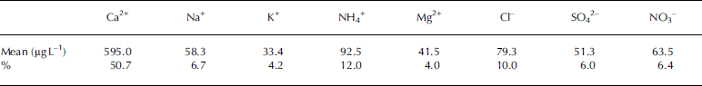
Table 2. Correlation coefficients between soluble-ion species in the firn profile from Yulong mountain

Table 3. EOF analysis of the major-ion time series of the firn profile

EOF1 accounts for 27.4% of the total variance in the major-ion series, is loaded with Na+, Cl– and K+ and represents ionic material of marine origin. The good correlations between them also indicate that they derive from the common source.
Mg2+ and Ca2+ dominate EOF2, which accounts for 22.3% of the total variance and represents a terrestrial source. Previous studies also show high calcium and magnesium concentrations in snow, snow pits and ice cores from the southeastern Tibetan Plateau (Reference Wake, Mayewski, Xie, Wang and LiWake and others, 1993; Reference Kang, Wake, Qin, Mayewski and YaoKang and others, 2000), reflecting a continental source from the arid regions of central Asia. However, the anomalously high calcium concentration compared with other chemical constituents (Table 1) indicates that the calcium is derived mainly from local limestone sources (Reference Li and SuLi and Su, 1996).
EOF3, loaded with NH4 +, is probably related to biogenic material derived from regional agricultural activities (Reference Shrestha, Wake and DibbShrestha and others, 1997; Reference Kang, Wake, Qin, Mayewski and YaoKang and others, 2000; Reference Hou, Qin, Zhang, Kang, Mayewski and WakeHou and others, 2003). NO3 – and SO4 2– dominate EOF4 and EOF5 respectively. Both SO4 2– and NO3 – correlate poorly with Ca2 + and Mg2+ (Table 2), which suggests that the origin of Ca2+ and Mg2+ is different to that of NO3 – and SO4 2-. With the development of industry in South Asia, the contribution of the industrial exhaust gases (SO2 and NOx) to air pollution is significant. It has been reported that over 60% of the sulfur deposited in Nepal is derived from Indian emissions (Reference Arndt, Carmichael and RoordaArndt and others, 1998), suggesting that the impact of long-range transport on pollutant deposition over other areas is significant. NO3 – and SO4 2– in the Yulong mountain area may therefore originate from industrial sources in South Asia. In addition, it has been reported that widespread biomass burning (firewood) for domestic energy in Nepal cannot be ignored as a source of NO3 – and SO4 2– (Reference Davidson, Lin, Osborn, Pandey, Rasmussen and KhalilDavidson and others, 1986). NH4 + correlates well with SO4 2– and NO3 – (Table 2), suggesting that the three ions are co-deposited as ammonium sulfate and ammonium nitrate salts (Reference Jang, Czoschke, Lee and KamensJang and others, 2002).
In summary, ONH4 +, S4 2– and NO3 – in the Yulong mountain area probably derived from anthropogenic sources, and are transported to the area by the Indian southwest monsoon in summer and by the south branch of the westerlies in winter.
3.2. Firn profile dating
High ice temperatures, intense melting, rapid ice movement and high sensitivity to climate change characterize the temperate glaciers in the Yulong mountain region (Reference Li and SuLi and Su, 1996). According to observations made at about 4800m on the glacier by Reference Su, Wang, Li and SuSu and Wang (1996) between June and July 1982, the temperature was close to the melting point in the uppermost 2 m of snow, but decreased to below 0˚C between 2.0 and 8.2 m depth. There was a slight increase below 8.2 m. These observations indicate the influence of meltwater percolation in the uppermost 2.0m is obvious. Although the deeper firn was once close to the surface and it had been affected by meltwater percolation at that time, after that it was probably less affected by meltwater percolation due to a relatively low temperature. The glacier consists of two zones from terminus to summit: the ablation zone and the infiltration–congelation zone (Reference Shi, Huang and RenShi and others, 1988). The sampling site is in the infiltration–congelation zone.
In the region of the southeastern Tibetan Plateau, seasonal changes of dust transportation cause the highest Ca2+ and Mg2+ concentrations in the troposphere to occur in spring (Reference Kang, Wake, Qin, Mayewski and YaoKang and others, 2000). Over the course of the ablation season, dust deposited in spring snow is concentrated on the late-summer ablation surface. The locations of summer surfaces can thus be identified on the basis of the distribution of dust layers, and these layers can therefore be used to date the firn profile. In addition, soluble ionic composition at dust layers is also higher than that at non-dust layers because soluble impurities are probably deposited synchronously with dust. Therefore EC (representing the total ion load) peaks in the firn profile are consistent with the dust layers recorded during sampling. The peaks of EC, Ca2+ and Mg2+ were used to date the firn profile because EC correlated well with Ca2+ and Mg2+. Each peak corresponds to a well-preserved dust layer on the late-summer snow surface. Therefore the snow accumulated between two peaks of EC (Ca2+, Mg2+) represents the net accumulation of snow within a balance year (October to the following September). Based on this dating, 13 complete annual layers were identified (Fig. 3). Identification of the years 2002 and 1993 may seem unconvincing because there are two additional significant EC (Ca2+) peaks within these identified years. However, there are no significant additional Mg2+ peaks within these years (Fig. 3). According to our field observations, the two additional EC (Ca2+) peaks correspond to two thin ice layers that may have formed by meltwater refreezing during late summer. Elution of soluble ions may be hindered at the level of these ice layers, resulting in EC (Ca2+) peaks. It has been reported that Mg2+ can be eluted more easily than other ions (Reference Iizuka, Igarashi, Kamiyama, Motoyama and WatanabeIizuka and others, 2002), so this may explain the absence of Mg2+ peaks at these levels. We therefore believe that the years 2002 and 1993 have been reliably identified. Additionally, the boundaries between the identified years 1997/98 and 1994/95 are not obvious. There are no peaks of Ca2+ and Mg2+ at the boundaries (Fig. 3), but there are two weak EC peaks that were used to separate the years 1997/98 and 1994/95. Thus there is probably little error in defining the years 1994, 1995, 1997 and 1998.

Fig. 3. EC, Ca2+ and Mg2+ records in the BG1 firn profile. The firn profile was dated using the peaks of EC, Ca2+ and Mg2+ in the firn profile. The dot lines generally correspond to the locations of dust layers in the firn profile recorded during sampling. The number 03 represents the period October 2002–September 2003, the number 02 the period October 2001–September 2002, etc.
3.3. Firn profile records
Because of the very difficult conditions under which the firn profile was sampled, the density of the firn profile was not measured. In order to reconstruct the net accumulation, density data from the 10.1m firn core recovered in 1999 were used (Reference He, Yao, Cheng and YangHe and others, 2001, Reference He, Yao, Theakstone, Cheng, Yang and Chen2002). For the 1999 core, the density was measured at 10cm intervals. From the surface to the depth 10.3m of the 2004 firn profile, seven complete annual layers (1997–2003) were identified (Fig. 3). For each identified year, there are two boundary depths of the 2004 firn profile which were used to identify the year. The mean density of firn between two boundary depths of the 2004 firn profile was replaced by the mean density of firn between the same two depths of the 1999 core. For the identified year 1997, the mean density value between the two depths 8.6 and 10.3m (the two boundary depths which were used to identify the year 1997) of the 2004 firn profile was replaced by the mean density value between the depths 8.6 and 10.1m of the 1999 core. From 10.4 to 18.3m depth of the 2004 firn profile, the uniform density 0.8 g cm–3 was used, because the firn below 10.3m depth is close to ice. Therefore the density values for the 13 identified years were calculated based on the density data of the 1999 core. The net accumulation time series can also be reconstructed. Long time series of meteorological observations have not been made in the high-altitude Yulong mountain area. In order to study the influence of meteorological conditions on the net accumulation of snow at BG1, meteorological data from Lijiang, 25km to the south, were used. Figure 4 shows the reconstructed net accumulation at the accumulation zone of BG1 and the mean temperature of the melting period (May–October) at Lijiang from 1991 to 2003. It is obvious that there is a negative correlation (r = –0.46, p = 0.1) between them, suggesting the temperature during the melting period plays an important role in net accumulation. Additionally, the correlation between the net accumulation and precipitation at Lijiang (not plotted in Fig. 4) was analyzed, but the correlation between them is very weak. The correlation between the reconstructed net accumulation and the temperature is not significant at the 0.05 confidence level nor is the correlation with precipitation, which may be caused by the following two reasons. Firstly, the effects of precipitation and temperature on the net accumulation may be counteracted partially. Secondly, the densities of samples from the 2004 firn were not measured, but inferred from measurements on the 1999 ice core. Some error in the reconstructed net accumulation could be introduced by the density data. The correlation between temperature and the net accumulation is more obvious than that between precipitation and the net accumulation, probably indicating that the net accumulation is more sensitive to temperature than to precipitation in the temperate glacier area under the global warming condition.

Fig. 4. The reconstructed net accumulation in the accumulation zone of BG1 and the mean temperature during the melting period (May–October) at Lijiang, 1991–2003.
The seasonal variation in the δ18O profile is very weak (not plotted in Fig. 3), resulting from the meltwater percolation and presumably also the fact that part of the annual layer is actually missing due to melting. However, it is interesting that the annual mean value of δ18O is significantly negatively correlated with the Indian southwest monsoon (WSI1) index during 1991–2003 (Fig. 5). The WSI1 index indicates the intensity of the Indian southwest monsoon (Reference Wang and ZhenWang and Zhen, 1999). The correlation coefficient between the δ18O time series and WSI1, –0.55, is significant at the 0.05 confidence level. In the southeastern Tibetan Plateau, the ‘amount effect’ of stable isotopes in summer monsoon precipitation is very significant (Reference Araguás-Araguás, Froelich and RozanskiAraguás-Araguás and others, 1998). The more intense the Indian southwest monsoon activity, the higher the rainfall and the more depleted it is in heavy isotopes. Although the seasonal variation of δ18O has been smoothed by the meltwater percolation during the summer ablation season, it is possible that the summer monsoon information can be retained by the δ18O records in the firn profile. Firstly, there is net accumulation during the summer monsoon season, although summer snow ablation at the sampling site is also significant. The snow accumulated during the summer monsoon months originates from marine air masses driven by the Indian southwest monsoon, and information about summer monsoon activity must be recorded in the snow. Secondly, the meltwater itself is also tagged with the summer monsoon signal because it is mainly produced from summer snow. The δ18O values in snow within a balance year must be homogenized by isotopic exchange between snow and meltwater during the meltwater percolation process. Thus it is reasonable to assume that information about the summer monsoon is recorded by the δ18O values. This result indicates that reconstruction of paleo-Indian southwest monsoon activity is possible using δ18O records from ice cores drilled in the monsoonal temperate-glacier area.

Fig. 5. Variations of the WSI1 index and the δ18O record of the firn profile on Yulong mountain, 1991–2003. The negative correlation between them is significant.
The reconstructed NH4 + concentration in the firn profile from 1991 to 2003 is shown in Figure 6. It is clear that the NH4 + concentration was low from 1991 to 1997, and higher from 1998 to 2003. The variation of NH4 + concentration seems to relate to that of WSI1 during the 1991–2003 period. Specifically, the low concentration of NH4 + from 1991 to 1997 corresponds to low values of the WSI1 index, while the high concentration of NH4 + from 1998 to 2003 is associated with high values of the WSI1 index (Figs 5 and 6). This suggests that the higher the southwest monsoon intensity, the higher the NH4 + concentration. It has been reported that a higher proportion of NH4 + in snow over the high Himalaya during the summer monsoon season is linked to a stronger monsoon circulation, advecting air masses rich in NH3 that originates from agricultural and biogenic sources in low-lying areas (Reference Shrestha, Wake and DibbShrestha and others, 1997). A linkage between NH4 + in the firn profile on Yulong mountain and the Indian southwest monsoon activity is therefore possible. However, there is a need to confirm this linkage with additional data from other monsoon temperate glacier areas because post-depositional processes can also influence the ammonium concentration in snow (Reference SunSun and others, 1998).

Fig. 6. Variation of the NH4 + concentration in the firn profile from Yulong mountain, 1991–2003.
4. Conclusions
The following conclusions can be drawn from the above analyses and discussions: (1) the chemical species in snow and firn on Yulong mountain originate from three different sources, marine, crustal and anthropogenic; (2) the variation in net accumulation of snow at Yulong mountain is controlled by temperature fluctuations and is less influenced by precipitation, probably indicating that the net accumulation is more sensitive to temperature than to precipitation in the temperate glacier area under the global warming condition; (3) although the isotopic composition is influenced significantly by post-depositional processes, especially meltwater percolation, the correlation between the WSI1 index and the δ18O record of the firn profile on Yulong mountain is significant, confirming that information about past Indian southwest monsoon activity can be obtained from ice cores drilled in the monsoonal temperate-glacier area.
Acknowledgements
This research was supported by grants from the National Natural Science Foundation of China (40501014 and 90511007), funding from the orientation project of the Chinese Academy of Sciences (kzcx2-yw-317) and the fellowship project of the Chinese Academy of Sciences (0723411001). We greatly appreciate suggestions from the two anonymous referees for the improvement of our paper. We also thank M. Sharp for language editing and helpful comments and suggestions.


