
Gold – this is what the eighteenth-century monsoon traders often called the silty strip of land they saw as their ships approached the littoral coasts of the Bay of Bengal. One may debate whether it was a metonymy for the wealth hidden in the rich alluvium or simply the result of a common mirage created by the mangrove ecosystem. This silt, responsible for creating the lower Bengal Delta, will be the starting point of this book. There are many routes to understanding the genealogy of property in colonial India. One obvious point of entry is through the intellectual history of property regimes, while another one would be the treatment of property claims in court cases. Avoiding these common approaches, this chapter will take silt – or, to be more precise, the intractable soil–water admixture peculiar to the Bengal tidal basin – for understanding the material and social processes of making property in a swamp. Silt, as Kipiling notes, is imbued with power and destruction, terms that characterize the fate of one of the East India Company’s merchants in eighteenth-century Calcutta.
Nearly one-third of colonial Calcutta was still a swamp during this period. The swamps that became landed property through the nineteenth-century straddled a shifting terrain, both metaphorically and materially. The materiality of these spaces challenged the “solid” grounds for infrastructure and design, while metaphorically these swamps revealed the limits of Company’s laws. This chapter explores a moment when one of the early colonial attempts to construct a harbor for Calcutta in the eighteenth century failed. This failed harbor is important for understanding how the British managed the ecology of the subcontinent over the next century and a half, restructuring the littoral landscape, shaping laws about urban property and creating a market in urban land. Following the failed attempt, the British officials turned to legal responses instead of technological adaptation to manage these spaces. This raises the following question: How did the mobility of the silty coast govern and organize the conversations around law and design in the colonial and metropolitan courts? In analyzing the terms through which the Mayor’s Court in Calcutta and the House of Commons in London debated the case of the failed harbor, this chapter pursues the following line of inquiry: Why and how did law become the basis for managing these spaces? What were the conditions that enabled the legal straitjacketing of what was considered geographical difference in the “tropics” and ecological variability of tidal deltas?Footnote 1
During the latter half of the eighteenth century, an erstwhile British draftsman-turned-private-merchant named Benjamin Lacam was discovering all the possibilities that were embedded in the malleability of the silty coasts at the edge of the Bengal Delta. He was sure that the silt the tidal Hooghly River, brought down to the flatlands forming coasts along the delta on its way to the Bay of Bengal, held a financial windfall for him. He was not wrong in his judgment, though his economically and ecologically speculative project to operationalize his harbor never saw the light of day. As the years went by, the vagaries of the silt and tides that make the delta turned his fortunes around, embroiling him in a thirty-year legal battle from which he barely escaped the debtor’s prison and also lost his honor and investments in Bengal.
Legislating the Vagaries of Silt
Benjamin Lacam arrived in Calcutta in 1760. Thirteen years after establishing himself in various roles as a draftsman in the new construction work in Calcutta, he made his way down to the mouth of the delta to the newly acquired farms of the South 24 Parganas, a territory that included the mangrove forests of the Sundarbans. The silt brought down by the Ganga-Brahmaputra river system on the eastern part of the subcontinent was already known as one of the most fertile soils in the entire world. While the mangrove areas were known to be harder to penetrate, there are records of early land grants in the Sundarban area dating as far back as the eleventh century. During the sixteenth century under the Mughals, Sufi saints from various lineages carried out extensive land reclamation and cleared forests for wet-rice cultivation.Footnote 2 On acquiring these lands, the British saw this area as uncharted and unmapped forests and wastelands waiting to be reclaimed and brought under the Company’s revenue rolls.Footnote 3 In 1774, Lacam, who had not yet acquired the ranks of the coveted tax collectors of the East India Company’s newly stolen farm, ventured into the tidal waters on the east of the Hooghly River to Baratulla Creek to seek his fortune in a different manner.Footnote 4 Here, he found a small patch of land that he claimed to be a “naturally forming harbour” and sought a grant from the East India Company with the purpose of building wharves and dry docks.
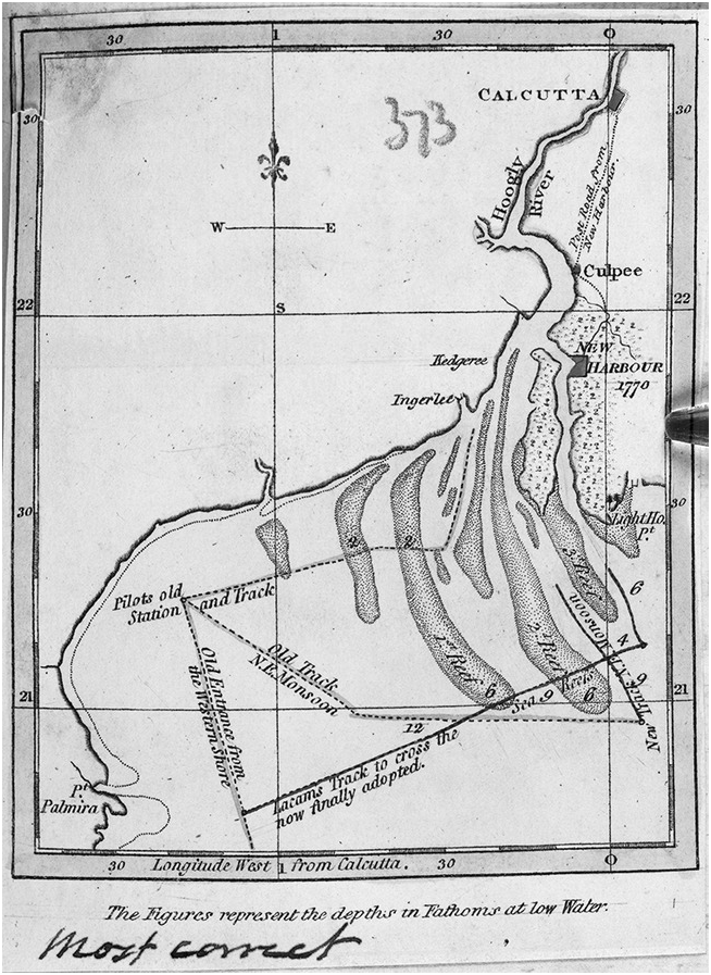
In this silt-laden riverine place Lacam speculated on a scheme for capital, wealth and power – all of which he had scant access to during his brief stint in Calcutta. Why did the proposition of building a harbor seem like a lucrative venture for Lacam, when the well-known practice was to try one’s hand as a tax farmer?Footnote 5 In Figure 1.1, a rare trilingual hand-drawn map (c. 1730) from Frederick Barlow’s collections (more on him later), we see the Hooghly River whose western banks were fast silting up during the eighteenth century.Footnote 6 On the eastern side was the narrower Channel Creek, flanking a small sand-head known as Sagar (Saugor) Island. This is where the European boats left the bay to navigate their way to Calcutta through the inland riverine channels.Footnote 7 Larger ships would often need pilot boats, better adapted to tides, shoals and shifts in the river’s movements, to navigate the European merchants and their goods back and forth from Calcutta.
Figure 1.1 Map showing the sea face of the Sundarbans
The shipping and country boat industries were booming in the Bengal Delta through the eighteenth century. Kedgeree (or Khejuri, in the top left corner in Figure 1.1), one of the major anchorages in the Hooghly side of the river handling the highest amount of trade, was fast silting up.Footnote 8 Every mariner and ship jobber was familiar with the vagaries of the Hooghly River and the treacherous entry into Calcutta.Footnote 9 The merchants of the East India Company were looking for an alternative, and Lacam, who had already spent thirteen years in service in Calcutta, was aware of the need for a different entry. The turbulent waters of the tidal river, cyclones and the raging Bay of Bengal had sunk many a ship and a great deal of precious trading material before reaching Calcutta.Footnote 10 Lacam proposed to build a harbor in the eastern side, on Channel Creek. His harbor was about twenty-six miles inland from the Bay of Bengal, and it would be the closest to Calcutta.
In 1774, the Revenue Committee of the East India Company in Calcutta granted him a patch of land to begin work. Lacam invested his money in constructing what he christened the New Harbour and hoped to profit from levying tolls from the boats and ships that would be docked there. Such private investments in public infrastructure were common not only during the Mughal period in India, but also in contemporary England.Footnote 11 Yet, two months prior to completion in 1776, the Company decided to withdraw the land grant for a number of reasons, the primary of them being the contradictory reporting of water depth. Financially ruined, Lacam returned to Calcutta to file a lawsuit in the Mayor’s Court. An almost thirty-year-long case began in an attempt to parse out the vagaries of tidal movements from the foibles of human avarice. No traces of Lacam’s New Harbour exist today, although it was supposed to be the solution to the flux that defined the mouth of the delta.
This chapter deals with the legal case filed by Benjamin Lacam in 1777, first with the Mayor’s Court in Calcutta, later appealed to the House of Commons in London and finally settled in 1806. In his complaint Lacam alleged that the Company had cheated him of anticipated profits on his investment by canceling his grant illegitimately. The Company, on the other hand, refuted his charges by arguing that Lacam’s geographical measurements did not match geological facts on the ground, therefore raising questions about the economic viability of his plans. How is this story about the rise and fall of a middling character like Lacam, a company servant and speculator, related to the history of the emerging market in land, construction and the speculative character of that market? What does Lacam’s failed harbor-building venture tell us about the changing nature of European geographical knowledge, geological debates and how those were written into the legal architecture around possession that was being crafted in Britain’s eastern colony?
If the colonial riverine geography of the Iberian Empire became a site to imagine political dangers, temptations for self-rule made possible by the coastal corridors and ultimately imperial territorialization, then a different history emerges in the tidal coasts on Bengal.Footnote 12 This thirty-year legal case serves as a cipher through which we can trace the dynamic unfolding and refashioning of metropolitan law’s attempt to apprehend an unknown geography and its vicissitudes in the creation of both legal structures and geographical knowledge. The legal battle surrounding Lacam’s harbor reveals the beginning of a century-long process where the multiple ways of understanding and living with the ecology of the tidal basin was condensed through contractual principles of ownership and scientific instruments of knowing and measuring space. Lacam’s project revolved around a new path for sailing to Calcutta from the Bay of Bengal that he claimed most sailors were not aware of. This new track had to be fortified by constructing a harbor on this mobile landscape to facilitate the movement of cargo and fleets. For the officials employed in Calcutta, the mariners who plied the region and the Company’s Board of Directors in London, Lacam’s legal case rested on uncovering the relation between geography, human error and law.
In arbitrating the case, the colonial officials grappled with the following questions: Was geography an unstable and an unreliable form of evidence; or was it a matter of human miscalculation, whether purported or otherwise, in order to make wealth out of mud and profit out of geographical indeterminacy? In deciphering this landscape and water bodies as it emerges in the legal debate and the remembered histories of the place, we begin to see the particular entanglements within geography, scientific developments of maritime measurements, geological sciences and law that the mobile landscape of the delta stitched together. This case also laid the groundwork for geographical formations in the tidal delta to become part of the legal, governmental and scientific authority in the empire, thus slowly transforming the relation between land, water and forms of possession that inhere in those spaces.Footnote 13
Lacam’s harbor emerges as a site for reading the consolidation of colonial power as a bureaucracy of violence. In what follows, this chapter reads the various arguments and legal reasoning used in Lacam’s case, including the depositions, refutations and the legal proceedings by the company servants, merchants, sailors and builders as sets of information about what they perceived as an indecipherable ecological difference. The lawmakers in Calcutta and London reinscripted this information into a particular legal semiotics of property, with a broad-ranging impact that rearranged the space of the tidal swamp in the colony.Footnote 14 The debates about the geological features of a tidal delta and science of harbor construction became sites for producing legal testimony, arbitration around ownership disputes and compensation. This case illuminates two emerging aspects of colonial power at the turn of the eighteenth century: first, the politico-social world that the Company was establishing as an expanding imperial power in South Asia; and second, a particular colonial social network where “nature,” “ecology” and “property” all emerge as historically contingent categories created in and through the debates and discussions between the lawmakers, company servants, petitioners and mariners. As we will see, each of these groups had different ways of reading the material landscape.Footnote 15
Geography as Evidence
In 1760, at the height of the seven-year Anglo-French War (1756–63), or what was known as the Carnatic War in India, Lacam set forth on a ship from Madras to Bengal with the ambition of making a fortune. He was skilled in drawing and was armed with a recommendation to Henry Vansittart, the then Governor-General of Bengal. On his arrival in Calcutta, Vansittart first appointed Lacam to be an assistant to his secretary’s office, where Lacam’s drawing skills brought him recognition. From there he was promoted to the position of Assistant to the Chief Engineer of Fortification and New Works in Bengal. Lacam’s ambitions proved too wide for his narrow position as an assistant and draftsman, and he took charge of the musters, volunteered to clerk for the treasurer’s office and set about diligently detecting fraud and discrepancy in the new construction works in Bengal. Construction, it seems, was always beset with corruption. Lacam left a mark with the Court of Directors of the East India Company because of his assiduousness in detecting and eliminating corrupt practices in the office.Footnote 16
Lacam, who now considered himself on the path to amassing greater fortune than his office as the Muster Master of the treasury allowed him, left Calcutta soon thereafter. He set forth to the Sundarban area, a mangrove forest at the entrance to the Bay of Bengal and the mouth of the Hooghly River. Marshy tracts, dense undergrowth, saline creeks and a whole host of wildlife, from tigers, to crocodiles to a rich bounty of fish, populate this region. Life and livelihood in this area is shaped by a very specific relation that binds humans with animals in the soaking ecology of the Sundarban. Tiger gods and river spirits appear as mythic figurations and constitutive elements structuring the politico-ethical world in the land of mangrove and tides.Footnote 17 Even in the latter half of the eighteenth century, much of the area was neither charted nor mapped by the British, although the Mughals settled substantial tracts in the Sundarban area during the sixteenth century.Footnote 18
Although the Company acquired the rights to farm this area in 1757, it soon discovered that property in land and silty riverine spaces was less about contracts and productive control and much more about obligations, gifts, social capital and political power.Footnote 19 Initially, they were unable to make any serious efforts to survey the area.Footnote 20 With much difficulty, the Company was able to secure the services of Captain Robert Barker and Captain William Swallow and a huge retinue of kanungo (registrars of a fiscal division), who set out to “prepare a plan of the course of the Great Lakes, sound its depths of water, etc.”Footnote 21 Sounding was a particular method to measure depth of water as well as detect the presence of shoals, sandheads and barriers in rivers and oceans by using a heavy piece of lead attached to a line. According to their survey, the zamindars (landlords) had over 816,446 bighas of land, and they collected rent on 454,804 bighas, just half of the land in their possession.Footnote 22 The rest of the land was “either barren and untenanted, or assigned over to servants, idols, etc.”Footnote 23 The Company soon realized that land assessment in this area required specialized knowledge and decided to farm out the lands to people who possessed those skills. A concerted effort at reclamation and mapping began much later under the Collector General Claude Russell in 1770.Footnote 24
Thus, for the initial sixteen months following the acquisition of the South 24 Parganas in 1757, the Company collected revenues and thereafter leased the lands to the highest bidder on three-year terms. The Indian zamindars claimed those lands, water, mangroves and forests as their own, and some came forward with high bids to the Company. Although the Company wanted to farm the lands itself, Zephania Holwell, the tax collector and self-styled zamindar of Calcutta, worried that keeping the lands such as those on the silty riverine delta in the inexperienced hands of the Company would inhibit them from discovering the real value of land.Footnote 25 Giving it to the Indians, he surmised, would produce a “private confederacy” in those lands that would be “injurious” to the Company’s interest.Footnote 26 Unlike the Jessore or Bakarganj districts, much of which was also mangrove forest and settled as patitabadi taluks (waste or fallow land), in the case of the 24 Parganas, the Company wanted to take a different approach and keep the area under their direct control, especially given its proximity to the various ports and Calcutta. Ultimately, that was not possible.
The “conundrum” of assessing the extent and value of the area, however, was not unique to just the mangrove forests. Even the Permanent Settlement Act of 1793 did not properly solve the Company’s problem with land assessment. Rather than a clear demarcation of proprietary rights, landed property traversed a flexible terrain of political deals and negotiations.Footnote 27 In the meantime, the Company divided the entire area into fifteen parcels. Through a public auction they leased these parcels to indigenous merchants, former Indian proprietors and some company servants.Footnote 28 Benjamin Lacam was one such proprietor.
Here, in this shifting riverine entrance, Lacam’s fortune and failure would be etched. He applied for a grant of land, but unlike the other proprietors, he did not wish to be an agrarian landlord.Footnote 29 Rather, he wanted to privatize a piece of the coastline and eventually hold private rights in the name of Company’s public works. Unlike the other proprietors, Lacam initially received a very small tract of land of 100 bighas. Following his stint in construction in the new Fort William in Calcutta, built by the Company following the Battle of Plassey in 1757, he decided to try his luck by initially becoming a supplier of building material. He set up a chunam (lime) works in the Sundarban area and became a contractor for the Company’s expanding infrastructural and building works. He soon succeeded in this endeavor, supplying lime at a cheaper rate than at the existing market prices, beating his competitors who were supplying chunam from Sylhet, a city on the Surma River in northern part of Bengal.Footnote 30
In the process of establishing himself as the lime supplier to his old office, the Department of Fortification and New Works, Lacam cleared vast tracts sixty miles downstream from the English settlement in Calcutta to make wharves for shipping lime and also for building smaller vessels (known as sloops or country boats) better adapted to inland riverine trade. His work in the Sundarban area familiarized Lacam with the vagaries of the landscape, and, entrepreneurial as he was, he soon discovered an opening for a new venture: to build a permanent harbor there. While working as a contractor of lime for the Company he began surveying the channels and making soundings of the area to fathom its depth of water at both high and low tides.Footnote 31 This was an early attempt to improve Calcutta’s connection with its southward ports at the mouth of Bay.Footnote 32
Private investment in public infrastructure might strike us as unusual today, but that was not the case in either early modern South Asia or England. During this time, banias (Indian bankers) who worked closely with the imperial treasury of the late Mughal Empire financed infrastructural works. Constructing ports (bandars) was as lucrative as owning a marketplace.Footnote 33 Ports were part of the wide network of pilgrimage, war and trade routes in the Gangetic plain, drawing revenue through tolls, taxes, ferry passes, overseas port customs (mir bahari), pilgrimage dues and market taxes (zakt). Bijayaram Sen’s Tirthamangal, a didactic poem composed in 1777, attests to the growing importance of ports along the Gangetic plain.Footnote 34 Some of the important inland ports in seventeenth- and eighteenth-century Bengal were Shahbandar in Dacca, Bakshabandar in Hooghly and Pachotera in Murshidabad. These were the dominant ports before Khejuri, Sagar and Calcutta became the primary centers of European trade. The Nawab (King) of Bengal collected tolls through a wide array of administrative posts employed in these ports.Footnote 35 Lacam attempted to fashion his harbor along those lines with the hope of taxes from the passing vessels and rewards from the Company through an elevation of his status.Footnote 36
With the permission from the Revenue Committee in Calcutta, Lacam began to invest his own money for the purposes of “publick works” as he defined it.Footnote 37 One of the earliest British descriptions of the site where he began work on his harbor predates Lacam’s so-called discovery of the place and comes from Captain John Ritchie, who initially surveyed this area between 1767 and 1770. Ritchie described the place in the following words: “[It was] secure from every wind, and the water never being agitated any thing worth notice; for the tides in it are strong, and they are also irregular in their motions, occasioned by the sudden bending of the River at nearly right angles.”Footnote 38 Borrowing from Ritchie’s description, and claiming it to be his discovery, Lacam made a case to the Company that the constant ebb and flow made it a strategic harbor location. Ultimately in 1770 Lacam won a unique land grant to privatize this space in the name of public service.
How do we read Lacam’s glossing over of Ritchie’s earlier survey and his claim to discovery? Although a comprehensive survey of the area had yet to be conducted, Lacam’s analyses were built on existing small-scale surveys. Apart from the earlier French and Dutch riverine surveys, Captain Plaisted conducted a separate small survey in 1760. As far as land survey was concerned, Robert Barker conducted the first one with great difficulty.Footnote 39 This was followed by a statistical survey of the landholdings by William Farkland, who was appointed as the tax collector of the “New Lands,” as it was called for some time.Footnote 40 There were two other surveys of this newly acquired land. Marine Surveyor Captain John Ritchie undertook a nautical survey of the land–water admixture lasting three years from 1767 to 1770.Footnote 41 The other was much more extensive in scope, conducted by Major-General James Rennell, whose survey of the lower Bengal Delta began in 1764 and was completed over a period of thirteen years. Lacam’s survey, conducted on a much smaller scale and with the purpose of demonstrating the potential for Channel Creek and the surrounding area to be an ideal wharf for the Company’s ships, drew tactically and selectively on Ritchie’s surveys. While he borrowed and corroborated his facts with Ritchie’s work, he had to exchange heated letters with Rennell to disprove Rennell’s findings and establish his deductions about depth of water in this space.Footnote 42 Lacam argued his intimate experience with the landscape made him a better judge than Rennell’s scientific abstractions. Such contestations between experiential and scientific knowledge were common, especially when cases such as Lacam’s ended up in law courts. John Heilbron’s and Tal Golan’s study of the Wells Harbor case in Norfolk, which took place around the same time, documents a similar rift between the veracity of experience on the one hand and the expert claims of abstract scientific facts on the other hand.Footnote 43 Lacam claimed that his initial surveys revealed that the site had the potential to be a harbor, offering a new passage circumventing the treacherous entrance on the Hooghly to Calcutta – thereby promoting the trade and military position of the town. He further added that his personal experience with the landscape was also corroborated by other surveys.Footnote 44
Lacam was not wrong to draw on earlier surveys. Surveys during that period straddled various genres of representation and narrative, and were a collaborative effort across generations based on collection, collation and collaboration.Footnote 45 “Geographical science” was, according Thomas Best Jervis, an engineer and surveyor with the East India Company between 1819 and 1830,
[t]he simultaneous exertions of many individuals wholly unknown to each other, to institute inquiries preparatory to that enlarged and more exact acquaintance with the relative situation of countries and objects on the surface of the globe, its precise form, dimensions, distribution, and local peculiarities; these all have followed successively at intervals, as investigations supposed to have originated in fortuitous circumstances which some one or other of the foregoing causes had contributed to elicit or suppress.Footnote 46
This account fittingly describes the nature of the task Lacam undertook. Neither a geographer nor a trained surveyor, Lacam based his findings on earlier claims and “the knowledge he gained from long, long experience” to make his observations about the landscape where he had been toiling at his lime works for a number of years.Footnote 47 Knowledge about the swamps of Bengal was created as cases about Lacam ended up in the legal courts as a matter of jurisprudence of evidence. Facts slowly congealed around the contestations between the laws of men, including the speculators, surveyors and judges, and the laws of the inscrutable tidal swamp.
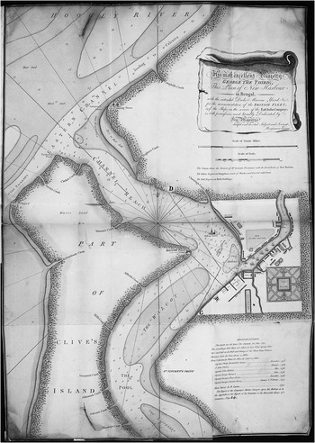
Lacam argued to the Revenue Department of the East India Company that New Harbour was a strategic location, given that it was tucked away from the unstable tides that surrounded much of the area around the factory town of Calcutta and the mouth of the Hooghly River. Moreover, Lacam stressed that the site he chose for the New Harbour was without the dangers of the shoals or sandbanks that the Hooghly River disembogued annually. Commenting on the existing passage, the master-navigator Captain Ritchie previously declared that “Nature” had done little for the safety of the Hooghly River and that “[a]rt has done nothing to accommodate them, in repairing, cleaning and rebuilding.” Therefore, one is left to procure large sums of money here to repair the “injuries of Time.”Footnote 48 This space was a “naturally forming harbour,” according to Lacam, and building the docks would afford the merchants of the company with a new route (marked as Lacam’s track; see Figure 1.2), which had the double advantage of being shorter, while also avoiding the old and treacherous channel and its multiple sand banks (marked as Old Track, or Old Entrance; see Figure 1.2). He further added that the Company would gain all of this without spending any of its own money.

Figure 1.2 Map showing Benjamin Lacam’s proposed routes and the New Harbour location.
Many of the merchants and marine surveyors attested to the difficulties of crossing the bay into the river to get to Calcutta and to the limitations of navigating the tidal basin.Footnote 49 Captain John Hicks, who had been employed in the sea service of the Company for nineteen years, during which period he commanded ten commercial and military ships, spoke in favor of Lacam’s proposed venture. The difficulties of navigating the entrance of the Hooghly River arose from the fact that it was hard to calculate or expect sufficient depth to navigate large ships.Footnote 50 The capriciousness of the tidal river meant that ships could cross only during high water. Therefore, each crossing had to be accompanied by the time-consuming task of sounding the river to gauge if sufficient depth was available for the purposes of navigation. Hicks was not the only one who spoke about the dangers of the river. Captain Newte, another merchant, further added that “the water in the Old Channel [existing path] was so shoal, that the East India Company’s ships, when laden, are obliged to sail for many miles in water not above a foot deeper than what the ship draws.”Footnote 51 According to Captain Robert Preston, one of Lacam’s colleagues, the absence of sufficient water depth meant that boats were often halted in their journeys to the ports of either Kidgree or Ingelle, little over a hundred miles from Calcutta. Not only did this cost the Company a great deal of money, but often merchant ships had to turn around and return before unloading their entire shipment in Calcutta or one of its neighboring ports.Footnote 52
Commercial losses were not the only reason driving the necessity of a safe harbor. The presence of the Dutch and the French competition along the coast meant that the British needed harbor infrastructure and military fortification to protect their Calcutta stronghold. Captain Preston added that any passage of ship
would be attended with the utmost difficulty and danger to attempt getting a line of battle ship into the river Hughly by the Channel now in use, which is amazingly changed, by reasons of Sands, from what it was when Admiral Watson passed it; that the risque now would be immense, for a ship above twenty feet draught to pass Ingelle.Footnote 53
This old channel was daily becoming worse, thus causing immense harm to the King’s service. Given the general opinion about the treacherous nature of the existing channel and the need for an alternative route, Lacam scoped out a new venture in his harbor, an area surveyed and explored in depth, he claimed, only by him.
In the process, he advanced an infrastructural solution to the mercantile military limitations posed by the tidal river. He proposed to build his harbor with his private money and the Company’s support through land grants and supplied the Company with the plan shown in Figure 1.3.Footnote 54 In the month of February 1774, he applied to the government in Fort William, Calcutta, for a land grant of 100 bighas, and within a fortnight his grant was approved at the existing rental rate for “wasteland.”Footnote 55 He then began deforesting the area and displacing the coastal settlement of “wild beasts.”Footnote 56 In October 1775, within a year and a half, he intimated to the government his decision to build a wharf for the Company there since this space provided a critical new track in the treacherous river where “[s]hips of any Burthen, may ride secure at all Times and Seasons, sheltered from every Wind, and in no Case subject to the Inconveniences arising from the excessive rapid Tides, known to prevail … [in] every part of Huegley River, quite to Calcutta.”Footnote 57 In the words of his supporters, the New Harbour was “a Place, entirely of his own forming.”Footnote 58 It is surprising that each one of the sailors and surveyors who supported his proposal spoke of the flux in land and water in terms of anomaly: caprice, vagary, changeable and subject to the strange moods of the rivers.

Figure 1.3 Map showing Benjamin Lacam’s proposed harbor plan.
There was consensus that the space was anomalous and needed to be managed. For the next year, Lacam worked on building a pier and a wharf to accommodate the largest ships of the Company. The Company supported him through further land grants and by supplying him with chains for moorings, material for his docks and gates from the stores in Calcutta to expedite the construction works. By the winter of 1776 his harbor was nearly complete. In February 1776, a month before its expected completion, he asked the Board of Directors for two things. First, he wanted them to support his application for another tract of land through a grant of four hundred bighas, substantially larger than his previous request from the Calcutta Committee of Revenue. Second, he wanted the Company’s Master Attendant to survey the channel up to his harbor “which might prevent any deception” as to ownership.Footnote 59 For the first time in his dealings with the Company, Lacam turned the rights vested in the land grant into a question of ownership. It is at this point that his New Harbour scheme became a flashpoint in a thirty-year-long legal battle, as Lacam turned the land’s use-value into exchange-value, and privatized the flux in nature, turning anomaly into a contestation around profits.
The initial problem began to emerge when the Director of the Calcutta Revenue Committee realized that the land grant would include a substantial number of water bodies. The surveyor, who was discharged to New Harbour, unfortunately could not complete his survey or take measurements. He reported that much of the mangrove forest was “infested with tigers” and that the survey orders on this “subject respected land only; whereas Mr. Lacam’s address to them spoke both of land and water.” Not only would such a survey cost more, but it would go beyond “the spirit of their orders.”Footnote 60 At this point we must pause and understand how this specific geography became entangled in colonial legal debates.
Recent scholarship has demonstrated the impossibility of disentangling law, imperial geography and cartography from each other.Footnote 61 The legal geography of the empire reveals the nature of territorial sovereignty, especially along the littoral coasts or maritime spaces. Attention to questions of law and geography, according to Lauren Benton, shows that for both the imperial officials and legal writers, the theoretical questions surrounding sovereignty and justice were inseparable from the local legal politics and the interimperial contests.Footnote 62 Attention to the local legal politics – for Lacam surely had many enemies, including Barlow, who accused him of deception, as well as Rennell and Ritchie, who held differing views about the geography of the space – reveals something other than political void or questions of sovereignty. Both Rennell and Ritchie, surveyors of the lands and waters under the Company’s jurisdiction, had political stakes in shaping the geography of the delta toward productive purposes. Geographical authority was a prized possession in imperial expansion. Apart from the disputed nature of ownership of the land, questions of geology of the tidal delta played an important role.
Benton’s work has already unsettled the idea of bounded, land-based empires to reveal fractured legal geographies coexisting with unregulated spaces. This opened the space for a study of how both real and imagined spaces were products of nonmetropolitan articulations of law, legal visions and the ad hoc nature of legal reasoning and jurispractice.Footnote 63 Renisa Mawani pushes the terrestrial and maritime divide to focus on amphibian legalities, thus raising the question of how we attend to the specificities of a tidal swamp or the char ecology of this area. If char was understood as geographical difference, how did it affect the question of law? In the case of Bengal, this means specifically: How did physical features that remained beyond the purview of Western geographical science, including a tidal moving landscape, where land and water seemed inseparable, shape property laws and lead to a legal doctrine to settle geographical disputes?
Lacam’s failed infrastructural project organized questions of property, environment and law in the colonial and metropolitan court. The geographical specificity of the Bengal Delta demands that we frame the legal question differently. This is especially true of the landscape Lacam wanted to acquire, possess and integrate into the space of Calcutta. Thus, questions of ownership in the temporary sandbanks, which were neither land nor water, had to be managed differently.Footnote 64 The concepts of delta, land, river and tides emerged as scientific concepts within the legal domain and everyday metaphors to understand geographical exceptions. These exceptions required translations within law and infrastructural discussions in order to mediate metropolitan desires with the “unstable” colonial ecology.
In Lacam’s case, for instance, before the soil could be understood as measurable, mappable property and a productive entity, it first had to be produced both materially and ontologically. For the soil to be abstracted into capital, it first must be recognized as productive soil. This was not always the case in eighteenth-century Bengal, a place where the arrangement of space through abstraction as capital was always interrupted by the natural forces of the fluvial landscape that challenged any pregiven ontology of the soil.Footnote 65 If we move away from the one-dimensional ways in which Lacam’s plans depicted this space and remind ourselves about the almanac forms of understanding the mobile nature of this landscape, we see that soil is temporary in the lower Ganga Delta basin. What is soil today might be a floating land–water admixture tomorrow, thus challenging all existing ideas of territorial or conceptual fixity.Footnote 66 The unsteady soil enters colonial discussions by interrupting legal systems of registering land and scientific techniques of measuring water depth.
The presence of water also threw up questions of use rights. Captain Ritchie noted the question of use rights in his deposition in 1777 with regard to Lacam’s land grant. While Captain Ritchie understood the relative advantages of the site, he could not address the question of whether private property could be invested in the water bodies within the granted land in the Channel Creek. He was concerned whether a land grant to Lacam “could be given without invading the common rights of mankind.”Footnote 67 The problem of soil–mud–water admixture would continue to affect the workings of both the legal and the engineering departments of the Company. The Company’s bureaucratic arm would have to constantly fashion a new administrative language to demarcate a moving landscape and new techniques for draining and fixing it. As we will see in the following chapters, parsing out land from water was both an engineering feat and a legal machination.
The problem did not simply end there. If the definition of where the land began and where the water ended was a problem, then the other geophysical challenge came from the flux in the measurement of the depth of water, a critical point affecting the navigability of the Company’s cargo ships and army fleets. James Rennell declared Lacam’s sounding of the water depth invalid. Lacam claimed that one of the reasons why his New Harbour was better suited for the task was that it boasted a more constant depth of water, thus providing safer passage than the older track, and was accordingly better suited for mooring for repairs than any of the existing harbors at that point. Lacam used the conventional lead and line to fathom the depth of the water, even though early forms of chronometers and sounding instruments had already been introduced.Footnote 68 Moreover, Lacam claimed experiential veracity over Rennell’s scientific abstractions.
The courts fought a long and bitter battle starting in 1777 over the depth of the water, which failed to yield constant measures. As it turns out, marine soundings in the legal records were not innocent evidence, and entered the courts entangled in debates around law and insurance, thus muddying the boundaries between marine science and fiduciary concerns. By the time the case reached London, the questions that the controversy surrounding Channel Creek opened up were as follows: Can the evidence of “geographical science” be trusted? And if science was not corrupt should the judges then argue the case as a matter of individual accountability and honesty? All of this had to be settled in order to secure ownership in land–water admixture.
Measurement in a Corrupt World
Human accountability is written into the history of instrumentation.Footnote 69 The law of evidence and standards played an important part in this history. However, what happens when measurements, or the failure thereof, are written into the history of property and ownership? In order to begin to deal with these questions, let us turn to the unfolding of the case and the subsequent arguments and debates that restructured the modalities of owning a mobile delta.Footnote 70 The history of European naval technology remains deeply enmeshed with the “discovery” of geographic novelties in the colonial environments. This intertwined history of technology and environment forces us to pay careful attention to the materiality of land and waterscapes.Footnote 71 This involves recognizing the two-step cognitive process that constituted Lacam’s discovery of new geographical features.Footnote 72 The first step involved parsing out a moment in the fluvial timeline when deltaic mobility was named a permanent harbor. Lorraine Daston calls such naming “anchor[ing] permanent words to impermanent things, once and for all.”Footnote 73 This was a classificatory act that condensed and flattened the variety and variability embedded within the fluid ecology of the landscape. The second step involved gathering scientific data through standards, measurements and customs to develop what I am going to call a scientific or “geographical bracketing of that space.” Lacam demarcated, surveyed and named a particular land–water formation as the “New Harbour.” In the act of calling this space a harbor, Lacam condensed the variety embedded in this marshy mobile landscape, but also attempted to flatten its temporal variability.
Describing the scientific project of developing a global language of cloud terminology, Daston pointed to the “collectively willed ontology” of seeing, parsing and naming nature.Footnote 74 In Lacam’s case we get a glimpse of that same project of willed ontology, which took a different trajectory. This was not just an act of naming, but also the production of a collective act of seeing this space as a harbor. Daston’s work on how a meteorological understanding of clouds was produced through the nineteenth century alerts us to this process. According to her, this particular “achievement of collective seeing and naming was made possible by terse descriptions that focused attention on a few key details and – even more important – obscured myriad of others. All classification depends on some degrees of abstraction from the blooming, buzzing world of particulars, accentuating some significant features and muting others.”Footnote 75 What remains specific to naming geographical formations, like their meteorological counterparts, is that they must be both temporally and spatially fixed before they change forms and enter a different taxonomic register.Footnote 76
Yet, unlike Daston’s project, Lacam’s act of naming failed to become a collective venture. The language, metaphors and frames that Lacam and his supporters developed failed to globalize. After all, the Bengal Delta is a mobile landscape; what is silt today is swamp tomorrow, and perhaps headed for the bottom of the Bay of Bengal in the future. By developing, however indeterminately, a system of measuring the depth of the water to account for this space’s practicability as a site for a harbor, Lacam attempted but failed to forge a common geographical consensus. This is why his case was an infrastructural failure, and in the process created legal dilemmas over the question of ownership of watery spaces. It was this act of collapsing variety and variability of this rich ecological world that would animate the discussions around the navigational metrics and legal terminology of accountability as Lacam’s legal case began unfolding.
Following Lacam’s petition against the Company, the judges in Calcutta convened a committee in 1783 to hear the oral evidence and look into the papers about this case that, in its final form, runs into over 750 handwritten and printed pages of material. On consulting the material, the committee divided the evidence into three categories in order to extricate the nature of geographical design and human error since it was difficult to ascertain whether Lacam was lying about the water depth or whether the other surveys were untrustworthy. The first two sections of evidence were geographical: one concerning the dangers of the older channel; and the other concerning the advantages of Lacam’s proposal. The third section dealt with the human category. This consisted of papers documenting how and through what means Lacam acquired the tract of land from the government in Bengal, and on what basis his access to those grounds was later canceled.Footnote 77
The judges also collected oral and written evidence from the merchants and mariners who traded and sailed in the Bay of Bengal, and catalogued them under the first two evidentiary categories to account for the relative military advantages of Lacam’s New Harbour over the old channel. Under their last body of evidence, they turned to the depositions, requests and surveys submitted by Lacam. Lacam’s proposal for the initial land grant was carefully crafted to request assistance to establish a wharf in a “place so well-formed by nature.”Footnote 78 After the first failed survey of the area, undertaken by the Company, John Ritchie’s 1776 survey approved the space as suitable for a harbor, although he refrained from commenting on the political expediency or economic viability for a harbor. Based on Ritchie’s report, the Board of Directors and the Revenue Committee in Calcutta approved Lacam’s land grant. While this land grant was meant to include both the landmass and the water bodies within the purview of the grant, Ritchie had his reservations. Although Ritchie had not conducted a formal cadastral survey of the area before, he was nonetheless deeply familiar with the nautical landscape of the Bay of Bengal and Hooghly River, having undertaken an extensive hydrographical survey of the rivers and coasts of the Bay of Bengal between 1767 and 1770.Footnote 79 Thus, he was familiar with the mutability of land and water in this landscape, even though he might not have had the terminology to explain the geological nature of the tidal delta and the changes it wrought upon the earth’s surface. Ritchie’s long familiarity with the landscape had also made him sensitive to the gap between the epistemological space of a land grant and the physical materiality of that space. As a legal and financial instrument, land grants of the delta fell short of representing the fluvial space in question.
Once the harbor was near completion, Lacam wanted a stipulation entitling him to the harbor and the profits arising out of this venture. More than demanding a privatization of this landscape, he wanted unconditional entitlement to tolls or taxes from the ships passing into his channel. This, he argued, was due to him for the gains the Company would achieve from his discovery of this new track to Bengal. He was particularly set on securing the toll he would receive from the passing ships and from any ship in need of his harbor for refitting. He also claimed that this would defray the costs of building the harbor. There were three critical voices of concern that stalled his project permanently. One of them came from Captain Ritchie, who doubted the political need for such a harbor in this mobile landscape. The second one came from Major Rennell, who raised doubts about Lacam’s measurement. Finally, the third and perhaps the most powerful voice was that of Lord Cornwallis, the then Governor-General of Bengal, who doubted Lacam’s personal integrity due to what he took to be the dubious nature of his profit motives for this venture. Swamps, it seems, produced murky characters who appeared in official records as political threats.Footnote 80
In April 1790, the Committee met to decide the case of Benjamin Lacam. They began by consulting the original grant in order to assess the rights granted to Lacam and the equitable authority of the government to revoke it. Lord Cornwallis, who was then presiding over the Committee, finally decided that the passage into Lacam’s new channel was “attended with the most imminent danger [and] consequently pronounced the scheme to be visionary and ill founded, and so far from being likely to yield affluence and credit to Mr. Lacam, or those concerned with him, the prosecution of it, I conceive, would more probably have entailed ruin and bankruptcy upon them.” Cornwallis further added that Lacam’s persistence in his plan, even after seeing the surveys denouncing it, “is further proof how much men engaged in schemes of speculative advantage may be led astray, how liable they are to have their judgment warped in favour of plans which their own zeal have projected.”Footnote 81 With that the Company decided that it was right to revoke his land grant and dismissed his petition, but also offered him a handsome annuity of 600 pounds in compensation. After this decision, Lacam returned to England and attempted to settle his debts rather unsuccessfully. He barely escaped the debtor’s prison. In 1803, Lacam made another petition to the House of Commons in London, after hearing that both the Company’s and His Majesty’s ships had ventured into his channel. After careful consideration of the written and oral records, the House again dismissed his petition, but not without raising his annuity to 1,000 pounds.
After that Lacam disappears from the archive, only to surface later in a vitriolic undated handwritten note probably from the first decade of the nineteenth century by a certain F. Barlow, who accuses him of selectively borrowing from Captain Ritchie’s map by claiming it as his own. Barlow conjectures that Lacam did foresee that his track would be rendered unusable as a harbor, but adds, “It is of little importance now however – for it is most improbable that this track will ever be received under any circumstances short of a cataclysm.”Footnote 82 New Harbour disappeared into the river just as Lacam vanished from history.
Fluid Landscapes
Looking back at these records, it is surprising why the mobility of the landscape did not feature in the discussions about the factuality of the water depth, the search for accuracy within the instruments and the endless and nerve-wracking exchange over the character of Lacam. One probable explanation was the absence of any cognitive frames for understanding and capturing this tidal mobile landscape. Geological or earth sciences had yet to produce theories or narrative frames to explain the rapid flux that defined a deltaic landscape. The slow-moving changes wrought by the aqueous and igneous elements that created the earth’s crust as a gradual process of accumulation and erosion, did not enter the popular discourses until the publication of Charles Lyell’s Principles of Geology in 1830.Footnote 83
The lawyers, sailors, hydrographers and bureaucrats involved in the case did not know how to explain the discrepancies of depth measurement outside the frames of metrics or the lens of human integrity and morality. It is difficult to speculate whether they were inhibited by bureaucratic constraints of codification or scientific terminological limitations. What we can deduce from the available sources is that this mutability and flux became pivotal for Lacam’s venture. For Lacam, Channel Creek and its shores were a naturally forming harbor, and for his detractors it was a “place entirely of his own making.” Both statements are perhaps true depending on one’s interpretive frames. Thus, the Company, the Mayor’s Court and later the House of Commons could easily nullify his claims of ownership to that place.
It is astounding that metrics and character integrity were the only two possible ways to debate the situation in New Harbour, particularly since the vernacular literary and folkloric landscape is rich with riverine metaphors that attest to the sand and silt that often overtake the river. These sources also reveal the nature of the water that eddies down to join two shores at once during the monsoon. Boatmen in Bengal live both on and off these half-soil, half-water areas. The English geographical terms “erosion” and “deposition” fail to capture the range of intimate river–human experiences that are contained in Bengali.Footnote 84
In Bengali, for example, there are multiple ways of understanding erosion, signaling the diverse experiences of living with the river. Chapa bhanga is used when the river breaks away chunks of lands up to two meters wide as it flows during rainy seasons. Bhanga, on the other hand, refers to a form of erosion that wipes away a couple of acres of land in a matter of minutes and is experienced as a devastation that the monsoon brings regularly to this region. Hanria bhanga signals the strong undercurrents that sweep the soft, sandy bottom layer, causing the bank to hang precariously. Besides these three major terms, people of the lower Ganga basin employ other terms to understand the river’s behavior: Chechra bhanga occurs mainly when floodwaters recede, revealing a newly emerged char; bhurbhuri bhanga captures the bubbling of the river eating away sandy lands; nishi bhanga describes nocturnal erosion; and probol bhanga, a superlative of bhanga, refers to devastating bank erosion.Footnote 85 In vernacular geological understandings water and land shared a polyvalent relation, each moving and shaping the other slowly and catastrophically. These theories existed much before the nineteenth-century British men of science, such as William Whewell, James Hutton or Llyell, came along with their uniformitarian analysis of the earth’s crust.
Admittedly, it is difficult to translate and perhaps communicate in writing a language seeped in this watery vocabulary. Yet, it is precisely this wateriness that remains attuned to the mobility of land, water and everything in between the bounded space of land and the contained sphere of water. Contingency and indeterminacy are encapsulated not only at the rim where land and water mix, but also in our languages and our knowledge systems. It is these structures of knowing that shape and are shaped by our sensitivity to the fate of place in the larger discourses of space.Footnote 86 For the merchants of the East India Company, the changing depth of the tides appeared as an anomaly that could be fixed through either better instruments of measurement or the law. In the case of the New Harbour, such an anomaly led to an intense discussion around economic measures and legal instruments that might prevent further legal disputes of this kind. Ownership of such lands with water content exposed the limits of land grants. Unlike traditional histories around the contested nature of occupation and property in the colony, it was not a broken treaty but, rather, geography that exposed the limits of European epistemologies of property, which nonetheless failed to thwart the onward march of colonial capital. While the variability in the landscape needed fortification and strict methods of computing depth and tidal measurement, as the British would realize over the next century, only law could tackle this landscape to colonial advantage.Footnote 87
Where are the voices of the indigenous people who have been living with the land, water, fish and tigers for centuries? If this chapter has detailed the negotiation between a British merchant and the Company around competing notions of entitlement and how ownership questions were inflected by existing ideas about fluvial landscapes, the science of measurement and geography, then what can we say about the indigenous notions of entitlement to those watery spaces? Although the Indians who were living there were surely involved in the construction work in the harbor, they remain invisible in the archive. The only time we have any intimation about what the indigenous population thought about Lacam’s venture is when we sense the texture of human–land–water interactions that the legal and infrastructural debates cannot capture. John Ritchie ends his deposition with this “small voice of history”:
It is curious enough to observe the ideas which the country people entertain of the sinking of the wharf in Channel Creek: “Mr. Lacam,” say they, “having erecting a very tall flag staff, and hoisted colors upon it, within the districts of the Gangee Saub, without first making the proper oblations and etc. to that Deity, he in a rage at once sent the whole work to the bottom of the river, as a chastisement for so great a piece of presumption.”Footnote 88
This small voice, filtered as it is through the colonial archive, raises significant questions about ownership in a mobile world. “Gangee Saub” could only be a reference to the Hooghly River, a major distributary of the Ganga River . The locals believe that this river has the highest claim on the land that it creates since it is the river that gives them the land in the first place. Therefore, absolute ownership as envisioned by Lacam and the English law remained beyond the realm of the “natural” and all that is outside the purview of law and technology, namely, the natural movement of water and the silt it carries with it. The message of Ritchie’s account by the unnamed “country people” is that the forces and energies of the river challenge the idea of the ownership of “landed” property, since what is land today through drying was yesterday’s silt carried down by the river, and is now on its way to be deposited on the bed of the sea tomorrow. Riverine spirits acted as an ethical limit to human design and greed in the tidal delta.Footnote 89 They seem to be telling Lacam that land in this region is not atemporal and that one must learn to live with the temporariness of land and its flows and with water and its stagnations. Even if law abstracts silt into allodial rights, nature can always subvert it.
What transpired in this case was not merely a speculative venture gone awry, even though the colonial (and metropolitan) legal system could not locate who was responsible. Lacam’s annuity (or compensation) secured legitimacy in the court’s ruling against a harbor that had already begun to disappear into the river. One might argue that Lacam’s New Harbour could not be rendered intelligible through the available representational practices. Thus, the members of Calcutta’s Revenue Committee debated on how exactly to account for water bodies within the land grant made to Lacam. Others debated the limits of scientific instrumentation as evidence in a court of law. We can conclude that Lacam’s frustration in the harbor-building speculation was not due to the lack of artifice or the failure of the (ill)-reputed “British perseverance and enterprise,” but rather because the land in question was not ontologically available as land. Instead, the land had to be materially and conceptually produced within the legal and infrastructural ambits of the Company. As we will see in Chapters 2 and 3, such a spatial production occurred in three interweaving registers: nature, custom or law, and science. The history of this space, narrated through revenue accounts and colonial legal debates, is ultimately a narrative about how the land formations were manufactured. They were manufactured through law and technology involving multiple failures in producing that space.
Even if Lacam’s venture was a failure, though there might be some debate about the nature of such failures, it laid the groundwork for a particular arrangement of the space as an infrastructural landscape in this area and restaged the relation between law, geography and evidence. What was this particular arrangement? The following chapters turn to what I am calling the “manufacturing of a hydrological landscape.” This manufacturing did not merely entail consolidation of the land and waterscape as various forms of privatized landholding. It also involved abstraction of various judicial and legal fictions of ownership, as well as of things “apparently inaccessible to private appropriation (private property): nature, the earth, life energies, desires and needs.”Footnote 90 In the following two chapters I turn to those spaces within the infrastructural refashioning and hydroengineering of the landscape that resisted translations into mere economization and capitalist abstractions. In the process, I unearth those moments of empire-building where the ecological and sacral had to be accommodated into the envirotechnical reconstitution of these hybrid and aqueous spaces.