


Introduction
In November 1963 both the composition and crystal structure of the McMurdo Ice Shelf in the vicinity of the Dailey Islands (Figs. 1, 2) were investigated from cores from two hand-drilled holes. Both core holes penetrated through the shelf permitting limited study of the water underneath the ice.
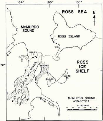
Fig. 1. Sketch map of the McMurdo Sound area showing the location of the Dailey Islands and the Koettlitz Glacier tongue

Fig. 2. Aerial trimetrogon photograph of the Dailey Islands and the Koettlitz Glacier tongue looking west. The locations of the drill holes are indicated by circles.
The Dailey Islands are a group of volcanic islands that project to a maximum height of about 250 m. above sea-level through the McMurdo Ice Shelf some 2 to 3 km. from its seaward edge. The McMurdo Ice Shelf was undoubtedly an integral part of the Ross Ice Shelf when many of the glaciers that now terminate on land discharged directly into the sea on the western shore of McMurdo Sound. Now, because of differences in regime, the McMurdo Ice Shelf can be said to exist independently of the Ross Ice Shelf (Reference Stuart and BullStuart and Bull, 1963) and only one land-based glacier, the Koettlitz, is contributing ice to its westernmost part at the present. Since the Koettlitz Glacier appears to extend as far north as the Dailey Islands, the portion of the ice shelf discussed in this paper could also be referred to as the Koettlitz Glacier tongue.
This shelf or tongue is of particular interest in that numerous fish and a large variety of marine invertebrates have been found on its ablating surface. The existence of organic remains on top of this ice has been known since the time of the early British expeditions of Scott and Shackleton (Reference FerrarFerrar, 1907; Reference David and PriestleyDavid and Priestley, 1914; Reference DebenhamDebenham, 1920, Reference Debenham[1949], Reference Debenham1961) and interest in them was revived recently when Reference SwithinbankSwithinbank and others (1961) discovered upwards of 50 partially decomposed fish near the easternmost of the Dailey Islands.
The most widely circulated theory for the origin of organic remains on top of floating ice is that of Reference DebenhamDebenham (1920, Reference Debenham[1949], Reference Debenham1961) who postulated that such animals might have become frozen onto the bottom of the ice shelf when the latter temporarily touched the sea floor. These animals were then presumably conveyed to the top of the ice shelf as a result of surface ablation and continued freezing of sea-water onto the bottom. If the McMurdo Ice Shelf is nourished by the freezing of sea water onto its bottom as Debenham’s theory would require, then petrographic and chemical analyses of ice cores from the shelf should reveal this fact.
In order to test this particular aspect of Debenham’s hypothesis, two core holes were drilled close to the site where Swithinbank and others made their recent find of animal remains.
The Island and the Location of Animal Remains
The easternmost island of the Dailey group, located less than 3 km. from the ice front, is covered almost entirely with volcanic scree. A large number of erratic boulders and pebbles were also observed on the island including one large boulder of gneissic granite that measured more than 1.5 m. across. The island was encircled completely by a tide crack or zone of closely grouped cracks. In places these cracks were up to half a meter wide and the ice along them was often so jumbled and broken (blocks standing 2 to 3 m. above the general level of the surface) that from a distance it resembled a pressure ridge. Along the northern shore of the island—the side in the lee of the flow of the main body of ice from the Koettlitz GIacier tongue—the tide crack was separated from the land by a strip of level “lake-like” ice up to 200 m. across resembling a frozen moat (Fig. 3). It was along this side of the island near the tide crack that well preserved fish remains were observed at a number of places. These included whole fish as well as decapitated individuals and detached fish heads. Occasionally three or four fish would be grouped together. All the remains appeared to be confined to the seaward side of the tide crack. None were observed in the moat itself. According to Swithinbank and others these fish all belong to the family Nototheniidae, the most common of Antarctic fishes. Most of the remains were of unusually large fish up to 100 cm. or more in length. Even the smallest fish measured was 40–50 cm. long which is considerably larger than most of the notothenid fish caught in trawls by the biologists in McMurdo Sound at the present day. However, a number of large fish weighing up to 64 kg. have been taken from seals that came up through the fishing holes in the sea ice. It appears that these larger fish live at fairly great depths (Reference WohlschlagWohlschlag, 1964).

Fig. 3. Close-up of tide crack and upturned ice at its edge. The flat area between the tidal crack and the island is the moat
Of additional interest was the ice-cored moraine (Figs. 2, 4) extending for about a kilometer off the north-eastern corner of the island and rising 10 m. or more above the general surface of the surrounding ice. This moraine appears to be derived from the island because it is composed predominantly of angular pebbles and cobbles of the same kind of volcanic rock. The bulk of invertebrate remains was located either on or just to the side of the ice-cored moraine. In the moraine were found perfectly preserved sponges still attached in their position of growth to rocks and small pelecypods with both valves still joined along the hinge line. Similar observations have been reported by Reference DebenhamDebenham (1920) and Reference SwithinbankSwithinbank and others (1961). Thin-shelled pectens were also observed but were abundant at only one locality, in refrozen melt-water pools in a low part of the moraine. Other invertebrate remains included corals, terebratellid brachiopods, gastropods, barnacle plates, serpulid worm tubes, sponge spicules and fragments of Polyzoa. These deposits can definitely be assigned to the Taylor Formation (Reference SpedenSpeden, 1962) since they contain the distinctive species of thin-shelled pecten Adamussium colbecki (Smith) and other living species. Ten of the eleven Taylor Formation deposits listed by Speden in his classification of Quaternary fossils of the McMurdo Sound area overlie ice and are generally associated with ice-cored moraines. The Dailey Islands deposits thus represent another occurrence of the Taylor Formation in the McMurdo Sound area which overlies the ice.

Fig. 4. Close-up of the moraine. Looking west across the ice shelf to neighboring islands of the Dailey Islands and the Royal Society Range beyond
Away from the moraine the bulk of the debris on the surface of the shelf was composed of gravels and sands with a fair sprinkling of fine-grained silt-like material. The ice surface between the easternmost island and the next nearest island about 2 km. to the north (Fig. 2) was also examined, proving to be relatively barren of invertebrate remains. The most common organic material was the remains of siliceous sponges which were widely distributed over the surface of the shelf in the form of felted masses and balls of spicules up to 10 cm. across. Although occasional fish remains were observed, they appeared to be older and more desiccated than those found near the tide crack.
The Ice Surface
Figures 2, 4 and 5 give some idea of the surface melt-water drainage pattern and the extent to which pinnacled ice is formed on the dirt-littered surface of this part of the McMurdo Ice Shelf. It is quite apparent from this surface relief pattern that a considerable amount of surface ablation takes place during the summer. The thaw probably reaches a peak in late December and early January and much of the resultant melt water must be channeled into the relatively large stream beds that have become stenciled into the ice. During the few days in November that the party was in the field no extensive flow of water was observed but there was some surface melt.

Fig. 5. View of the dirt-littered, pinnacled ice shelf near the easternmost Dailey Island. Lower part of the photograph shows the moat separated from the pinnacled ice by a tidal crack. The hills in the middle of the photograph are mounds of ice-cored moraine. The edge of the ice shelf is clearly visible at the top left of the photograph. The flat white area is sea ice with open water beyond
Core Drilling and Results
The first of two core holes (Hole No. 1) was drilled near a group of fish located less than 50 m. from the tide crack on the north-eastern side of the island (Fig. 2). Here the tide crack was marked by considerable fracturing and upthrusting of ice (Fig. 3). The ice corer had penetrated 6.74 m. of ice when it pierced the bottom of the shelf. The hole was then invaded by fresh water which rose to within 0.98 m. of the surface. Density measurements of large sections of core gave an average value of 0.91 g. cm.−3. These results indicate that the shelf is “riding high” at this location; for a free-floating shelf of thickness 6.74 m. and average density 0.91 g. cm.−3, the freeboard should lie between 0.77 m. and 0.66 m. depending upon the salinity of the underlying water.
Variations in the bubble and dirt content of the ice cores were noted but these changes were transitional rather than sharp and no clear-cut layering could be detected. Bubbles of entrapped air up to 3 mm. in length were observed widely scattered throughout the ice. This in general resulted in particularly transparent cores. Dirt particles were also disseminated at intervals throughout the core. Some dirt grains measured more than a millimeter in diameter, but with the exception of a thin layer of debris at 0.45–0.46 m. depth, this dirt was never sufficiently concentrated to form distinctive bands. No trace of animal remains was observed in any of the cores. However, the possible existence of algae, especially in slightly discolored ice from 3.50–4.40 m. is being investigated in core samples sent back to the laboratory for chemical analysis. Conductivity tests on samples from Hole No. 1 indicate that the ice is of fresh-water origin, either glacial or the result of the freezing of fresh water. Conductivity profiles are given in Figure 6.

Fig. 6. Conductivity profiles of cores from Holes Nos. 1 and 2. The “salinity” values are based on the assumption that the ratios of the salts in the ice are the same as in standard sea-water. Analyses of re-cored ice from Hole No. 1 are indicated by open circles
It was of considerable interest to discover a layer of fresh water under the ice. Several attempts to determine the thickness of this fresh-water layer by measuring both the temperature and salinity with a combination thermohm—conductometer probe were thwarted by the rapid freezing of the fresh water between the electrodes. However, it was possible to obtain samples of this water by re-coring the drill hole after it had frozen. These cores proved to be as fresh as the ice in the shelf (see analyses indicated by open circles in Figure 6). The re-cored hole was also used to measure the depth to sea bottom which was found to lie 42 m. beneath the surface of the ice shelf. While making this sounding, considerable difficulty was experienced with some form of “slush ice” under the shelf. This slush must have formed some time after the initial drilling. When the hole was recored 9 days later, this slush was found to extend at least 3 m. below the bottom of the hole. Vigorous probing with a string of drill rods was required to penetrate the slush before the sounding line could be lowered to the sea floor. The exact origin of this slush could not be determined.
Hole No. 2 was drilled on the shelf approximately 400 m. from Hole No. 1. The ice at this location proved to be 15.25 m. thick and was also underlain by fresh water of undetermined thickness. The water rose to within 1.98 m. of the surface indicating that this part of the ice shelf was also “riding high”. With the exception of the ice below 12 m., which appeared to be completely free of dirt, the cores were megascopically very similar to those from Hole No. 1 with bubbles and dirt scattered throughout. Conductivity measurements (Fig. 6) indicate that the shelf at this location is also composed of fresh-water ice. None of the ice “salinities” exceeded 30 p.p.m. except for the bottom sample from each hole. Freezing in of the bottom of the drill hole prevented any probing of the water under the shelf or measurement of its depth. The only other available sub-ice bottom soundings from the vicinity of the Dailey Islands are from Reference CookCook (1963) who obtained water depths of between 200 and 600 m. on a seismic traverse across the Koettlitz Glacier 6 to 8 km. south of the site of the present study. From these and other data (Reference RobinsonRobinson, 1963) from McMurdo Sound it would appear that the ice in the vicinity of the Dailey Islands is underlain by rather deep water.
Despite the close similarity in external appearance of the two drill cores, thin-section studies revealed totally different ice types. Ice from Hole No. 1 near the tide crack was composed of both fine-grained and coarse-grained crystals which were frequently complexly intergrown. This mingling of two contrasted ice types together with the apparent absence of intermediate grain sizes is the dominant feature of the texture of the ice at this location. The principal textures observed are shown in Figure 7. Coarse-grained ice with dendritic sutured crystal outlines from a depth of 0.40 m. has clearly been formed from the freezing of water in a melt pool, and it is quite probable that the remainder of the ice from Hole No. 1 has formed from the freezing of fresh water in the general area of the tide crack and the moat. If this water originated as surface run-off this might also explain the dirt particles suspended in the ice. The ice textures are not those generally found in glacial ice with the possible exception of ice that has been subjected to intense shear deformation. For example, the texture of the ice from 2.65 m. closely resembles the textures found in phyllonitic mylonitesfine-grained rocks formed by intense deformation and recrystallization of originally coarse-grained rocks. The ice at Hole No. 1 may have once been “tide-crack” ice that has been subjected to large diurnal compressive stresses during the period of its formation. It is interesting to note that the ice from Hole No. 1 is texturally similar to the so-called “transition” ice of the Ward Hunt Ice Shelf described by Reference RagleRagle and others (1964) for which a similar composite origin has been suggested.
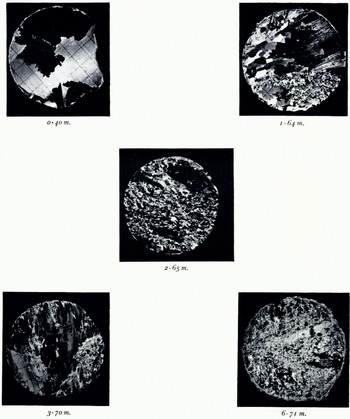
Fig. 7. Thin-section photographs of ice from Hole No. 1. Seclions photographed between crossed polaroids. The grid measures 1 cm.
Thin sections of ice from Hole No. 2 showed quite different textures. With the exception of the coarse-grained ice down to a depth of 0.58 m., which undoubtedly formed from the freezing of water in a melt pool, this ice was characterized by the allotriomorphic granular or mosaic type texture typical of glacial ice (Fig. 8). Undulose extinction, possibly indicative of intracrystalline strain was observed in some sections but universal stage measurements yielded little evidence for the existence of any strong c-axis orientations. A slight tendency towards a planar distribution of c-axes was observed in some sections, but there was a notable absence of any of the fabrics normally associated with strongly deformed glacier ice, e.g. “diamond” or single maximum fabrics. Some representative plots of the c-axis distribution in ice from Hole No. 2 are presented in Figure 9.

Fig. 8. Thin-section photographs of ice from Hole No. 2. Sections photographed between crossed polaroids. The grid measures 1 cm.

Fig. 9. Representative c-axis scatter diagrams of ice from Hole No. 2. All diagrams are in the horizontal plane
The textures and orientations of the ice from both cores bear no resemblance to the structures that characterize sea ice, namely the existence of brine pockets, intracrystalline platy structures and strong horizontal girdle type fabrics. These observations together with the megascopic properties of the ice indicate that at present the McMurdo Ice Shelf in the vicinity of the Dailey Islands is not being maintained by the freezing of sea-water onto its bottom.
Significance of Fresh Water Under the Ice
Although the discovery of fresh water under the McMurdo Ice Shelf is apparently the first observation of this kind in Antarctica, it is not the first time that fresh water has been found under ice floating on sea-water. There have been several reports from the Arctic of the occurrence of both fresh and brackish water beneath Arctic pack and shelf ice. (Reference NansenNansen, 1897; Reference CraryCrary, 1956; Reference Untersteiner and BadgleyUntersteiner and Badgley, 1958; Reference SchwarzacherSchwarzacher, 1959; and Reference Lyons and LeavittLyons and Leavitt, 1961).
Unfortunately, the thickness of the fresh-water layer under the McMurdo Ice Shelf could not be measured directly at either of the drill holes. The obvious assumption is that this layer extends under the shelf on a horizontal base. In this case the depth of fresh water at Hole No. 1 (near the tide crack) should be at least 8.5 m. which is the difference in the thickness of the ice between Hole No. 1 and Hole No. 2. This value might be compared with the 6.5 m. thick fresh-water layer that Reference Lyons and LeavittLyons and Leavitt (1961) measured near the landward edge of the Ward Hunt Ice Shelf at approximately the end of the melt period. There the fresh-water–sea-water interface was found to be very sharply defined, but how far this layer extends under the Ward Hunt Ice Shelf and what happens to it during the winter are not known.
It should be noted that the layer of fresh-water under the McMurdo Ice Shelf was observed at a time (November 1963) when little if any run-off of surface melt water could have occurred during the previous 7 to 8 months. This would indicate that unfrozen fresh water can persist under this part of the McMurdo Ice Shelf the whole year round. Such a layer of fresh water would insulate the bottom of the ice shelf against any accretion of sea ice.
In the Arctic Ocean freezing of fresh water onto the bottom of floating ice has been verified only in the case of pack ice. Reference Untersteiner and BadgleyUntersteiner and Badgley (1958) observed the growth of fresh-water ice onto the bottom of the ice floe at Station Alpha after a number of holes had been drilled through the floe to drain the camp area of surface melt water. Apparently small ice crystals form at the fresh-water—sea-water interface and float upwards until the fresh-water layer becomes filled with a mesh of fragile crystals. When crystals forming at the interface can no longer rise, the whole layer begins to solidify from the bottom up. In some places this layer of solid ice grew as thick as 0.2 m. but subsequent observations indicated that much of this ice underwent ablation later in the season. Reference SchwarzacherSchwarzacher (1959) was able to show that this fresh-water ice was restricted mainly to the camp area, occurring naturally only underneath thin ice 2.00 to 2.50 m. thick, a condition most commonly encountered near open leads where most of the surface melt tends to collect during the summer. Petrographic examination of a large number of cores from station Alpha (Reference SchwarzacherSchwarzacher, 1959) also showed that the formation of fresh-water ice does not contribute significantly to the total thickness of ice in the floe.
In regions of grounded and near-grounded ice, particularly in the vicinity of tide cracks, any growth of frazil ice at the base as depicted by Untersteiner and Badgley could be expected to incorporate dirt and other debris from the sea bottom. When accompanied by ablation at the surface such freezing could give rise ultimately to a column of dirt-ridden ice such as was observed at Hole No. 1. It might then be argued that megascopically similar ice at Hole No. 2 has originated under similar circumstances. The fact that the bottom 3 m. of core from Hole No. 2 contained no dirt at all might then be taken as evidence of continued freezing of freshwater ice onto the bottom of the shelf as it moved out of the tide-crack zone into much deeper water at its present location. Unfortunately the textures of the ice at the two drill holes are so dissimilar that it seems questionable whether they could have been produced by the same process. Growth of frazil ice (modified perhaps by deformation in the tide crack) can reasonably account for the textures in the ice at Hole No. 1, but at Hole No. 2 the textures seem more compatible with a glacial origin. Even a glacial origin is difficult to prove on the available evidence and direct comparison with cores of undisputed glacier ice further back on the Koettlitz Glacier tongue would be most desirable.
Any periodic freezing of fresh water directly onto the bottom of a floating ice sheet could be expected to yield visibly stratified ice. The complete absence of stratification in cores from the McMurdo Ice Shelf indicates that basal accretion is either not important under this part of the ice shelf or it is continuous. In any event direct normal freezing of fresh water to the bottom of the ice shelf would be expected to produce the strong c-axis vertical or c-axis horizontal orientations that are so characteristic of lake ice (Reference KnightKnight, 1962). These clearly were not observed. It should be suggested that the normal freezing of fresh water to the bottom of an ice shelf may well account for the origin of the so-called “stratified” ice described on the Arctic ice island t-3 by Reference Muguruma and HiguchiMuguruma and Higuchi (1963, p. 711–15). t-3 apparently originated from the Yelverton Bay area of Ellesmere Island (Reference CraryCrary, 1960), an area where one might expect a fresh-water layer under the shelf ice.
Mode of Uplift of the Fish and Fossiliferous Moraines
Commenting on the disposition of fossiliferous deposits in McMurdo Sound, Reference DebenhamDebenham (1921, p. 79) noted that, “The raised marine beds occur in such positions and so perfectly preserved that no pushing action of the ice masses can explain them”. As an alternative Debenham pointed out that where an ice shelf is decreasing by thaw at the surface and increasing by freezing at the bottom, the basal ice must ultimately reach the surface. If the ice occasionally froze to the sea floor then any fish and shelly muds incorporated at the base would gradually rise through the ice shelf and become exposed on the surface.
While actual freezing of ice to the sea floor seems necessary to the incorporation of benthic invertebrates by Debenham’s theory, adfreezing of the fish may not require contact between ice and sea bottom. The fish could be brought to the underside of a floating ice shelf by deep diving seals or they could have floated up to the base of the ice after having been killed and partially eaten by seals on or near the sea floor.
Only on ARLIS II, a floating ice island in the Arctic, has possible confirmation of the Debenham theory of the adfreezing of fish been obtained on shelf ice. According to Reference SmithSmith (1964) the remains of numerous fish in varying states of preservation were observed melting out at a number of places on what was identified as stratified sea ice. It seems very likely that these fish were frozen in at the base of the ice and subsequently exposed by surface ablation. The fish observed in the vicinity of the Dailey Islands also appear to have been frozen into the ice but in this case the freezing-in seems to have occurred in fresh water, not sea water. Also, their entrapment appears to have taken place rather selectively and independently of the fossiliferous moraines.
All the fish were confined to the northern or lee side of the island and most of them were located close to the tide crack. The marine invertebrates on the other hand tended to be concentrated in ice-cored moraines. The fact that the fish and invertebrate remains were never intimately associated, e.g. not a single fish was found in the fossiliferous moraines, would tend to indicate they have been lifted to the surface by different processes. Many of the fish were so well preserved that their skin and flesh were still intact and some smelled strongly of tallow. On the other hand no shellfish were found containing any trace of soft parts. Such remains might have been expected in freshly exposed specimens of pelecypods if they had been alive when picked up off the sea floor and frozen onto the bottom of the ice shelf. This might indicate that these invertebrates were derived from pre-existing fossiliferous deposits, possibly from “raised beaches” along the southern shores of McMurdo Sound or from the submerged edge of the island itself.
The observation that the fish were found only in that area of the tide crack situated in the lee of the flow of the main body of ice of the Kocttlitz Glacier tongue seems crucial since this almost eliminates any possibility of these fish having originated on some other part of the Koettlitz Glacier. If they had, then it becomes rather difficult to visualize just how these fish managed to position themselves so selectively along the tide crack in front of the moat. Considering all the details of their occurrence, it is difficult to escape the conclusion that these fish are very locally derived. The most likely origin is that these fish were brought by deep diving seals to the vicinity of the tide crack, where they became frozen in the fresh-water ice and have since been exposed by surface ablation. The bodies of two seals were found on top of the ice near the north-cast tip of the island but there were no signs of any seals having congregated recently near the tide crack.
At the time of their discovery by Swithinbank and others in November 1960 it was hoped that radiocarbon dating of these fish might throw additional light on their mode of uplift. Preliminary measurements indicated an age of up to 1100 yr. for these fish. However, recent studies have shown that Antarctic waters are somewhat deficient in 14C (Reference BroeckerBroecker, 1963). This leads to exaggerated ages. The error involved probably exceeds +800 yr. which means that the Dailey Island fish are probably no older than 300 yr. and are possibly much younger.
The observation that the bulk of the marine invertebrates was confined to the general area of the moraines would tend to indicate that both have originated contemporaneously. There is evidence that a considerable quantity of rock debris is working its way onto the ice from both the east and west sides of the island. This action is clearly demonstrated in Figure 2 where two lines of moraine can be seen extending off the island northward towards the ice front. Since the debris in the fossiliferous moraine that extends off the north-eastern corner of the island appears to be composed of the same volcanic rock as the island itself, it seems likely that the invertebrate remains were incorporated at some stage during the formation of this moraine. The fact that many specimens of the most fragile of sessile invertebrates were still intact when found would also indicate that their incorporation within the moraine does much less damage to the hard parts than previously suspected. The observations emphasize once again our limited knowledge of the mechanisms involved in the formation of even the simplest types of moraine.
Although the fossiliferous debris found near the easternmost Dailey Island appears to be locally derived, there are other deposits on the Koettlitz Glacier tongue that may have originated much further up the glacier where extensive outcrops of shell-bearing “beach moraine” are known to exist (Reference SpedenSpeden, 1962). An examination of Speden’s map of fossil localities in McMurdo Sound clearly reveals the close relationship of Taylor Formation deposits either to morainal debris on top of floating ice or to deposits on or near the present-day shore-line. For example, at the type locality near the mouth of the Taylor Dry Valley the deposit consists of abundant shells in a gritty sand that crops out over an area of hundreds of square meters and extends up to 15–20 m. above sea-level. At nearby Bernacchi Bay near the mouth of “South River”, Reference NicholsNichols (1961) discovered large numbers of shells of Adamussium colbecki in layers of silt situated approximately 4 m. and 6 m. above present-day sea-level. At both these localities the deposits have obviously been uplifted since their formation. This elevation of coastal areas can most probably be attributed to the isostatic uplift that followed deglaciation in McMurdo Sound.
Other recently discovered deposits of the Taylor Formation include the extensive “beach moraines”, up to 3 m. above high-tide level, that crop out along the north side of Minna Bluff (locations 16 and 17 of the N.Z.G.S.A.E., 1958–59 (Reference SpedenSpeden, 1962)). Additional fossiliferous areas are believed to exist in the moraine heaps on the ice shelf between Minna Bluff and Black Island. The Minna Bluff moraine beaches represent the southernmost deposits of the Taylor Formation and these and other “shore-line” deposits may constitute important source beds of the fossiliferous muds, sands and gravels now found on top of floating ice in McMurdo Sound. To quote Reference SpedenSpeden (1962, p. 762–63), “The linear moraine belts along the north side of Mina [sic] Bluff and around Black and Brown Islands show that up-thrusting and up-ploughing are common phenomena in the McMurdo Sound Regions, as they are in most ice-sheet environments. These mechanisms can explain the position and mode of occurrence of most deposits of the Taylor formation”.
In the particular case of the Dailey Island deposits actual dredging-up of shell-bearing debris from the submerged eastern edge of the island seems to satisfy all the important details of occurrence of these fossiliferous moraines. If adfreezing of the type envisaged by Debenham occurs at all it must take place only occasionally, for as Reference HoldgateHoldgate (1962) points out, organisms such as sponges and corals are not likely to survive for long on a surface that is constantly being scoured by ice.
Conclusions
The McMurdo Ice Shelf in the vicinity of the Dailey Islands is composed of fresh-water ice. Unlike sea ice, the cores from this part of the McMurdo Ice Shelf were remarkable for their clarity and lack of stratification and their salinities were much lower than would be expected for old sea ice. In addition thin-section studies of representative samples of these cores revealed none of the characteristic substructures of sea ice such as brine pockets and platelets or any marked horizontal orientation of the crystallographic c-axes. The ice thickness increased from 6.74 m. near the tide crack to 15.25 m. at a distance of 400 m. beyond the tide crack.
Ice from the thicker part of the shelf exhibited textures commonly associated with relatively undeformed glacial ice. However, the textures observed in much thinner ice from near the tide crack suggest an origin by either freezing of fresh water in the tide crack or extreme granulation of fresh-water ice in the general area of the tide crack. The existence of a layer of fresh water beneath the ice shelf can be attributed most probably to surface run-off during the ablation season. Much of this water has probably made its way down the tide cracks and down fissures radiating from the island. Drainage from the island itself especially in the vicinity of the moat is another likely source. Freezing of fresh water onto the bottom has almost certainly contributed to the growth of the ice shelf where the ice is thin, e.g. in the vicinity of the tide crack (Hole No. 1) and the moat, but in thicker ice (Hole No. 2) the textures observed in the core indicate that a glacial origin is more probable.
A detailed examination of the faunal remains found on top of the ice indicates that the fish have reached the surface by a different process from the marine invertebrates found in the moraines. With rare exceptions all the fish remains were confined to a narrow zone along the tide crack in front of the moat. Since this ice lies in the lee of the general flow of the ice shelf it would seem likely that the fish are very locally derived. It is suggested that they were frozen-in near the top of the tide crack, where they had been left by deep-diving seals and have since been exposed by surface ablation.
The concentration of marine invertebrates in the ice-cored moraine indicates that the fossils and moraine have originated contemporaneously. Since this moraine appears to be composed of debris from along the eastern edge of the island, it is concluded that the marine organisms were frozen in with the moraine at the time of its formation.
It should be emphasized however that the results of this paper only apply to a very local portion of the shelf where significant faunal remains are known to exist. It would be interesting to see if these conclusions apply to the McMurdo Ice Shelf as a whole. This extension would require at least some knowledge of the following items: surface ablation, rates and direction of ice movement, lateral variation of ice and fresh-water thickness and total water depth, distribution of faunal remains both near and between the islands, temperature profiles through both the ice sheet and the underlying water at several different times during a year, and the vertical and lateral variation in ice types at representative locations on the shelf.
Acknowledgements
The authors are indebted to the Office of Antarctic Programs, National Science Foundation for funds to conduct this study. The field support provided by VX-6, Special Air Development Squadron, U.S. Navy is gratefully acknowledged. Thanks are due also to A. P. Crary, J. B. Lyons and R. H. Ragle for their critical review of the manuscript.


