


Introduction
Patriot Hills is located at the southernmost end of the Ellsworth Mountains, West Antarctica, at 80°18' S, 81°22' W. It is a small range only 8 km long, with extensive rock outcrops, especially on its northern flank, and with the highest sum-mil of 1246 m protruding about 400 m above the surrounding ice sheet (USGS, 1966). Horseshoe Valley separates Patriot Hills from Douglas Peaks and Wilson Nunataks, the two latter ranges being located about 35 km north of Patriot Hills. The ice [lowing from Horseshoe Valley drains to Hercules Inlet, at the grounding line of the Ronne Ice Shelf, about 50 km northeast of Patriot Hills.
A bare-ice field about 8 km long by 2 km wide exists on the northern side of Patriot Hills. Bare-ice fields, known as blue-ice areas (BIAs), are areas with negative mass balance and comprise only a small part of Antarctica. BIAs are likely to occur in the escarpment region, i.e. an area of relatively steep surface gradient, located between the coast and the interior of Antarctica, where strong winds and low accumulation rates prevail (Van den Broeke and Bintanja, 1995). Ablation is mainly produced by enhanced sublimation over the bare ice, and erosion by divergence of wind-driven snow (Reference JonssonJonsson, 1992; Van den Broeke and Bintanja, 1995). Such ice fields are commonly found in areas near nunataks (Reference Orheim and LucchittaOrheim and Lucchitta, 1990), but can occur as well in areas separated from the mountains, where special microclimate conditions exist (Reference Takahashi, Naruse, Nakawo and MaeTakahashi and others, 1988). Detailed glacio-metcorological studies of blue-ice fields have been carried out by the above authors, including heat balance, interaction with katabatic winds and modeling of the climate sensitivity of BIAs.
The blue-ice field of Patriot Hills presents the best conditions in the area for landing with large aircraft on wheels (unpublished information from C.W. M. Swithinbank), having been used for over a decade for logistic purposes, particularly by a private company (Adventure Network International) that has established a large summer camp there.
Glaciological studies in the area of Patriot Hills have been scarce, and mainly limited to accumulation measure-ments from snow pits dug at a spacing of 50 100 km, along an International Geophysical Year traverse (Bull, 1971); aerial radio-echo sounding (Reference Jankowski and DrewryJankowski and Drewry, 1981); and a few ice-velocity measurements between Independence Hills and Patriot Hills (Ishimaru and others, 1995).
Recently, the Instituto Antàrtico Chileno (INACH), with the support of the Chilean Air Force, has started a glaciological program aimed at characterizing the mass-balance and ice-flow conditions around Patriot Hills (Anonymous, 1995). This paper presents basic results from glaciological measurements carried out during INACH campaigns in the vicinity of Patriot Hills in January and November 1995 (Casassa, 1996).
Field Measurements
Base camp was established about 500 m north of the blue-ice field, near station P5 (Fig. 1). Snowmobiles were used for transportation, with the farthermost station located 6 km away from the mountains.
Stake traverse
Three reference points, A, Β and E, were established on rock on the northern flank of Patriot Hills, close to the blue-ice field (Fig. 1). From there, 12 stations, between P1 and P9, were established injanuary 1995, with stakes along a line to the north to a point 6 km away from the mountains. of these, four stakes were drilled in the bare ice, and eight stations were placed in firn. All of the stakes were found and remeasured in November 1995. in addition, several new
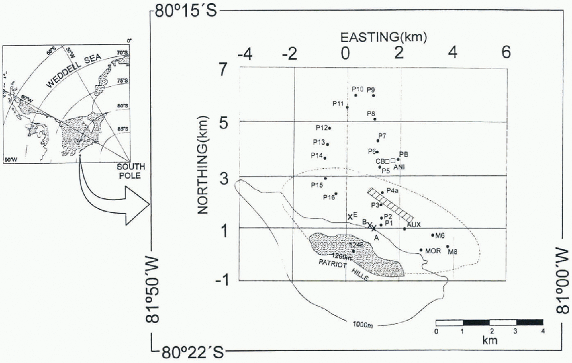
Fig. 1. Map of Patriot Hills, compiledfrom the USGS (1966) 1:250 000 map sheet and field data. Points A, Β and E were installed on rock. MOR is on a lateral moraine. Stakes M1-M5 (not on the map) were installed between MOR and M6, on the blue-icefield. Stakes M1 (not on the map) and M8, P1, P2, P3, P4a, P15 and P16 are located on the blue-ice field. All other stakes were placed on firn. PR and CB are the base camps in January and November 1995, respectively. ANI is the base camp of Adventure Network International. The hatched diagonal band represents the airstrip located on the blue-ice area. The stippled area indicates the main mountain range of Patriot Hills. The dashed line shows the approximate extent of the blue-ice field.
stakes, P10-P16 and M1-M8, were established in November 1995.
A traverse was measured during each epoch, using a local orthogonal coordinate system oriented to geographic north, as measured by sun observations. The origin of the coordinate system is 1000 m (N), 1000 m (E) at station A. A WildT2 theodolite, in combination with a Wild Distomat D14 electronic distance meter, was used.
Estimated standard errors are 10” in horizontal and vertical angles and 2cm in horizontal distances. At the farthest station (P9), this yields standard errors of 7 cm in the along-track coordinate (approximately northing), 9 cm in the across-track coordinate (approximately easting) and 13 cm in elevation.
Radio-echo sounding
A short-pulse high-frequency (HF) radar system was used, making discrete measurements at each stake. The system was mounted on sledges and towed with a snowmobile, using resistively loaded dipolc antennas. The transmitter, constructed at The Ohio State University (Huffman, unpublished), follows the original U.S. Geological Survey design. It consists of a 12 V power unit, producing an output pulse of 1600 Vpp, a pulse width of about 500 ns, and a repetition rate of 0.2 kHz. The transmitter has been used successfully on temperate glaciers (e.g. Reference Jezck and ThompsonJezck and Thompson, 1982; Casassa, 1992). The receiver consisted of a Hitachi VC-6045A digital storage oscilloscope connected through a serial port to a notebook personal computer, with a maximum averaging capability of 256 traces.
Results
Accumulation/ablation
The height difference of the stakes, measured at each epoch, was used in combination with firn densities obtained in a snow pit at base camp at each epoch to obtain accumulation and ablation rates for the 323 d periodJanuary-Novcmber 1995. A mean firn-dcnsity value of 376 kg m 3 was used, which is an average for the upper 20 cm layer between January and November. An ice density of 917 kg m 3 was used for the blue-ice field. làblc 1 shows the results.
Table 1. Ablation/accumulation rates. Negative sign indicates ablation, and height difference is the November minus January value. P9E and P9W are located 118m east and 169 m west of station P9, respectively
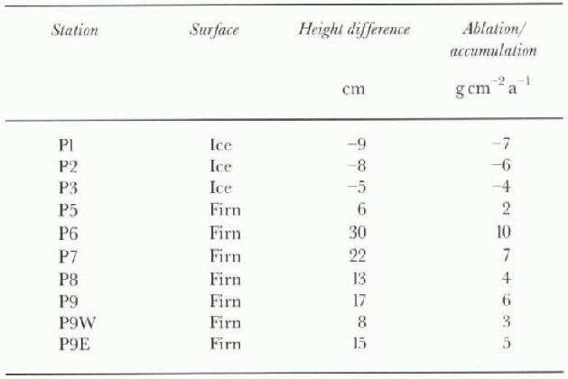
As anticipated, ablation occurs on the blue-ice field, being maximum at the southern edge of the ice, close to the mountains (P1). A large part of the ablation is expected to occur by sublimation (Jonsson, 1992), although some melting does happen during the summer, perhaps not every year but probably during very warm events, as evidenced by frozen pools found at the southern edge of the blue-ice field. However, relative amounts of sublimation and melting cannot be assessed, due to lack of heat-balance measurements.
At station P5, located near the northern edge of the ice field, accumulation is minimum. A large variation in snow accumulation can be observed north of P5. Probably this docs not reflect a spatial variation of accumulation rate, but is due to random sastrugi formation. Therefore, a representative accumulation rate in this area is 6 g cm −2 a−1, obtained by averaging the values for stakes P6-P9E. This is much smaller than the value of 15gem −2a−1 indicated by Reference Giovinetto and BullGiovinetto and Bull (1987) for the area. However, Giovinetto and Bull based their r esults on snow-pit data collected al a spacing of 50-100 km (Bull, 1971), which is representative of the ice sheet rather than the area near the mountains.
Our results indicate that snow accumulation around Patriot Hills is reduced by a factor of 2.5 as compared with the value of the surrounding ice sheet. Although on the blue-ice Held sublimation certainly contributes to ablation of the accumulated snow, there is sufficient field evidence to suggest that the prevailing southwest katabatic wind results in erosion by divergence of wind-driven snow (Van den Broeke and Bintanja, 1995) leeward of Patriot Hills. in fact, preliminary wind measurements indicate a 20—50% wind-velocity increase on the blue-ice field compared to the base camp site, located 500 m south of the edge of the blue ice. This is also evidenced by the size of sastrugi, which are clearly smaller away from the mountains, toward the north. Amplitudes of sastrugi of 40 cm are not uncommon just north of the blue-ice field, decreasing rapidly to the north, and becoming much subdued a few kilometers away from the mountains.
Surface-elevation changes
The resurvey of the Ρ traverse allowed elevation differences of the glacier surface to be computed over the period of 305 d between 15 January and 17 November 1995. Estimated errors in elevation (me) for each epoch are 3 cm at station PI and 13 cm at station P9, so the standard error for the elevation-change values is 7 cm for PI and 18 cm for P9.
Measurements were carried out at the stakes, which moved with the glacier, so elevation changes do not exactly reflect surface changes at the same location. However, since surface slopes and ice speeds are small (~1 % and ~5 m a−1 at station P9, respectively), the associated error is negligible with respect to measurement errors, with a maximum error due to advection of 4 cm at P9 for the period January-November.
Elevation changes are shown in Table 2. Elevation changes at stations P6 and P7 appear to be significant. How-ever, they occur in an area where sastrugi have amplitudes up to 40 cm, due to strong wind in the vicinity of the mountains, as mentioned earlier. Because sastrugi can migrate and/or form randomly, we consider that uncertainty in detecting elevation changes can be as high as 0.5 m near the blue-ice field. Since no elevation change greater than 36 cm occurred in the vicinity of Patriot Hills during the 305 d period, this indicates a zero mass balance within our uncertainty for the area.
Table 2. Elevation changes (November minus January)
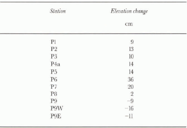

Fig. 2. Radar traces for transect P. The uppermost trace was measured at the edge of the blue-ice field, close to the mountains oj Patriot Hills. Labels correspond to stations indicated in Figure 1. Intermediate stations where no stakes were installed in the field are labeled P1.1, P1.2, etC. The large signal between 0 and 0.5 μs corresponds to the surface wave transmitted on the air-ice interface. The small signals to the right of the surface wave, between 0.5 and 4.5 μs, correspond to bed returns, indicated by arrows, which are progressively deeper away from the mountains. At P4a no bed return could be detected. The bed returns were amplifiedfor graphic purposes. The amplitude scale is shown for reference, with relative values, in volts, being valid only for the surface wave.

Fig. 3. Radar traces for transect M. See Figure 2 caption for explanation. At M8 no bed echo could be detected.
Radar measurements of ice thickness
Traces of radar data for transects Ρ and M are shown in figures 2 and 3. in these figures, the time origin, or zero-time, corresponds to the arrival time of the surface wave, transmitted to the receiver along the air/ice interface. Bed returns are seen on the trace diagrams as sinusoidal signals with small amplitude, which have an increasingly large return time as the ice gets deeper away from the mountains.
Ice depth (D, in m; figs 4 and 5) was calculated from the return time (tr, in μs) using the following equation, modified from Reference Watts and IsherwoodWatts and Isherwood (1978):
where ν1 is the speed of electromagnetic wave in cold ice (168 m μs −1 ; Matcheret and others, 1993), s is the antenna separation (36 m at transect P, and 31.5 m at transect M) and c is the speed of light in a vacuum (300 m μs−1). The average error in ice-thickness measurement is estimated to be 15 m.

Fig. 4. Profile of the glacier for transect P. Points correspond to field measurements. Ice depth ivas obtained from return times (Fig. 2) using the equation described in the text. The distance origin is located at the edge of the blue-ice field, close to the mountains.
Along transect P, radar data were recorded at slakes P1-P4a, including intermediate stations (figs 2 and 4). in spite of repeated measurements using different antenna configurations and orientations, recording 256 traces and using the highest oscilloscope sensitivity (2mV/div), no bottom echoes could be detected beyond stake P3, near the center line of the blue-ice field. A maximum ice thickness of 351 m could be detected at station P3 (Fig. 4).
Transect M was set up in the southeastern part of the blue-ice field (Fig. 1), in order to have a more detailed ice-thickness distribution. The M transect has a northeast direction from Ml to M6, and then turns 90° to the southeast, toward station M8. A maximum ice thickness of 383 m was detected at station M7.2 (Fig. 5). This value corresponds to the maximum range of the radar.
Ice-thickness values of about 1300 m exist toward the center of Horseshoe Valley, the valley separating Patriot Hills from Douglas Peaks, the latter being located 30 km northward (Reference VaughanVaughan and others, 1994), which shows that the present HF impulse radar system needs substantial modifications to sound deeper ice.
Bed profiles (figs 4 and 5) show an increase in ice thickness away from the mountains, with an average bed slope of 4% at the farthest point where ice thickness could be measured (P3 and M6 in figs 4 and 5, respectively). However, flatter subglaciol arcas are seen between stations P1 and P2, north of P2, and between M3 and M4. It is unknown whether these features are due to present erosional or depositional processes at the glacier bed or reflect instead conditions prior to the formation of the ice sheet.
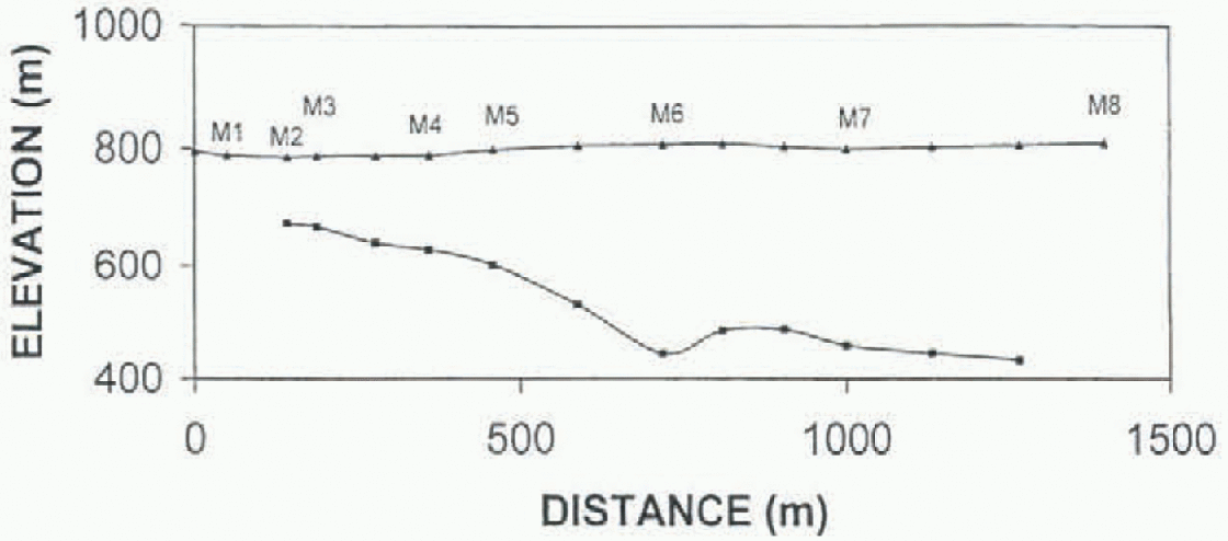
Fig. 5. Profile of the glacier for transect M. See explanation for Figure 4. The distance origin is located at the edge of the blue-icefield, at station MOR. on the lateral moraine (Fig. 1). The bed-slope change at station M6 is due to a 90°Change in the transect direction, as can be seen m Figure J, and explained in the text.
Conclusions
Glaciologie data collected in the vicinity of Patriot Hills allow the accumulation rate in the area to be characterized. The presence of the mountains exerts a strong influence on the accumulation pattern, probably by divergence of wind-driven snow flux, which results in reduced accumulation. Accumulation rate increases away from the mountains, with ablation occurring over the blue-ice field and accumulation in the firn area.
A maximum ice thickness of 383 m was measured with the HF impulse radar system, near the center of the blue-ice field. Modifications are needed in the receiving and transmitting units of the radar system in order to increase the sounding range.
Precise repeat measurements of stake heights after a 305 d period show no significant elevation difference, which indicates a near-zero mass balance for the ice sheet at Patriot Hills.
Acknowledgements
INACH sponsored the field expedition, as part of INACH project No. 158, “Glaciological Studies in Patriot Hills". The Chilean Air Force provided air transportation and valuable logistic support in the field. Data analyses were completed al Universidad de Magallanes. A. Oyaneder drew Figure 1, Valuable comments were made by R. A. Bindschadler and an anonymous referee.


