1. Introduction
The Antarctic ice sheets are a critical factor in the global climate and océanographie system. in particular, the contribution of the East Antarctic ice sheet (EAIS) to global sea-level fall during the Last Glaciol Maximum (LGM) has been an important problem for Quaternary research. From glaciological models, Hollin (1962), Stuiver and others (1981) and Denton and others (1991) proposed that the EAIS at the LGM extended to the edge of the continental shelf surrounding the Antarctic coast (CLIMAP model). Colhoun and others (1992), however, judging from the altitude and ages of Holocene raised beaches around East Antarctica, concluded that the ice margin during the LGM was thinner and less extensive than had been thought in the CLIMAP model. Igarashi and others (1995) also thought dial expansion during the LGM was slight, on the basis of the occurrence and distribution of 33-42 ka aged in situ marine fossils, albeit without stratigraphical description, in the Ongul Islands and northern Langhovde around Lützow-Holm Bay (Fig. 1).
Although it is a matter of great importance, there has been little agreement on the extern of the Antarctic ice sheet at the LGM. This is because no studies have so far been made that have included precise stratigraphical observations and accelerator mass spectrometry radiocarbon dating of fossils in emerged beaches. New data on the stratigraphy and ages of raised beach deposits on the Antarctic coast are important for the history of both the iee-shect extent and relative sea-level change during the Late Quaternary. in the present paper, we describe the stratigraphy of raised beaches, and TAMS (Tandetron Accelerator Mass Spectrometry) l4C dating ages of fossils on the northern Sôya Coast, where older dated fossils occur in close prox-imity to younger dated fossils, and discuss the peripheral fluctuation of the EAIS and sea-level change since the last glaciation.
2. Research Area
On the northern Sôya Coast facing Lützow-Holm Bay, several small raised beaches are located on ice-free rocks. Langhovde is the second largest icc-frcc area (50 km2), after Skarvsnes, in the Lützow-Holm Bay region (Fig. 1) and is bounded in the east by the Langhovde Glacier which drains northward from the EAIS. The topography of northern Langhovde is characterized by a low-relief crosional surface with whaleback-shaped outcrops (e.g. Mount Tyôtô: 380 m altitude). The landform features are controlled by the lithology and geological structures of the gneiss bedrock, and the surface is strongly weathered. These bedrock surfaces were entirely covered by an ice sheet during a Glaciol maximum stage of unknown age and were subjected to erosion, as evidenced by glaciated landforms and scattered erratic boulders in every locality. Ko-minato Inlet is an oval-shaped depression probably eroded by a glacier, and connected to Lützow-Holm Ray by a narrow passage (Fig. 2). Small raised beaches occur around Ko-minato Inlet, which is about 5 km away from the margin of the present ice sheet. Kominalo-higashi beach is the eastern one, and is characterized by several step-like topographies with a geologically controlled depression and a triangular opening to the inlet. During the summer, water supplied from snow patches and an active layer of permafrost melt to form small streams which flow westward and cross perpendicular to the steplike topography on the beach. We intensively surveyed the Kominato-higashi beach, where abundant fossil shells are found in sediments for the present shoreline up to 12 m a.s.l.

Fig. 1. Localities and classified 14C dates of marine fossils sampled from raised beaches along the northern Sôya Coast, East Antarctica. Data sources are Hayashi and Toshida (1994, appendix 3), Igaraski and others (1995) and this study. Contour lines of 200 and 500 m on land are quotedfrom the 1:250 000 topographic map (Lützow-Holm Bay) published by the Geographical Survey Institute, Japan. Isobaths of 500 and 200 m are quoted from Moriwaki and Toshida (1990).
3. Stratigraphy of Raised Beach Deposits, and Tams 14Cages of in Situ Marine Fossils
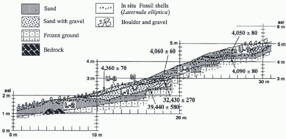
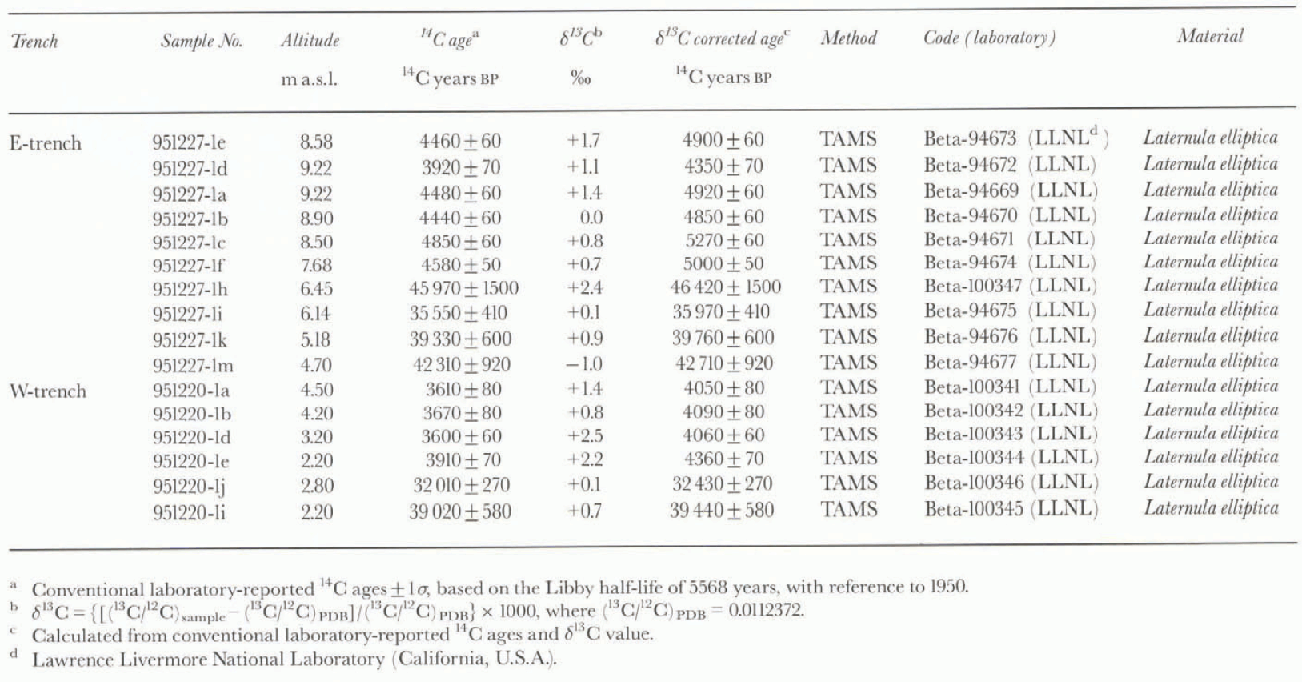
Two trenches were excavated by digging into the raised beach deposits on the left bank of the stream to reveal the stratigraphy and gcomorphology and collect fossil marine organisms. The detailed stratigraphy of the trenches is described in Maemoku and others (1997). They were named east trench (E-trcnch) and west trench (W-trench) (Fig 2-4). Altitude measurement was done with auto-leveling equipment and staff, and referred to the sea level observed at Ko-minato Inlet without tidal correction. Twenty-three samples were collected, and 16 samples were measured by the TAMS 14C dating method at Lawrence Livermore National Laboratory (California, U.S.A.) through Beta Analytic InC. (Florida, U.S.A.). All 14C ages were re-examined by the ![]() correction for isotopic fractionation effect on 14C/l3C ratio (see Table 1). However, we treat l4C ages without the reservoir correction, which involves subtracting about 1300 years for Holocene marine organisms in the Antarctic region (Berkman and Forman, 1996).
correction for isotopic fractionation effect on 14C/l3C ratio (see Table 1). However, we treat l4C ages without the reservoir correction, which involves subtracting about 1300 years for Holocene marine organisms in the Antarctic region (Berkman and Forman, 1996).
The trench profiles (figs 3 and 4) revealed two marine sediment layers with several bedding planes. The sediments yielded abundant fossil shells composed of Laternula elliptica buried in living position (in situ), and unbroken shells of Adamussium colbecki. The marine layers are separated by a fluvial gravel layer (M in Ε-trench and W-trench). The boundary between the lower marine layer and the fluvial layer shows a clear unconformity. The marine sediment layers are cut obliquely by subacrial processes that exposed them at the surface. Most of the beds are composed of well-sorted fine- to medium-grained sand with granule- or pebble-size gravel. Such facies with in situ marine fossils indicate that most deposits were formed in a beach and/or river-mouth environment.
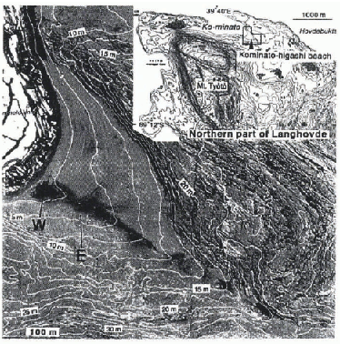
Fig. 2. Topography around Kominato-higashi beach, and sites of east trench (E) and west trench (W). Base maps are the 1:2500 scale colorphoto map (Ko-minato Inlet (east)) with 5 m contour interval, and the 1:25 000 scale topographic map (Langhovde: the northern part) with 10 m contour interval, published by the Geographical Survey Institute, Japan.
3.1. Lower layer
The lower beds probably extended to more than 7 m above present sea level, but the higher part has probably been removed by subsequent erosion. The lower layer is subdivided into two sublayers, L-1 and L-2.
L-2 is composed of fine- to medium-grained sand with in situ fossil Laternula elliptica. The l4C ages of fossils range from 46 420 ± 1500 to 39 440 ± 580 14C years BP.
L-1, conformably overlying L-2, is composed of medium-to coarse-grained sand with pebble-size gravel. The upper part of L-1 in Ε-trench is interbedded with pebble- to cob-ble-size gravel beds, and the upper part of L-1 in W-trench has deltaic foreset structure. The 14C ages of in situ fossil shells collected from L-1 are 35970 ± 410 l4C years BP (E-trench) and 32430 ± 270 l4C years BP (W-trench).
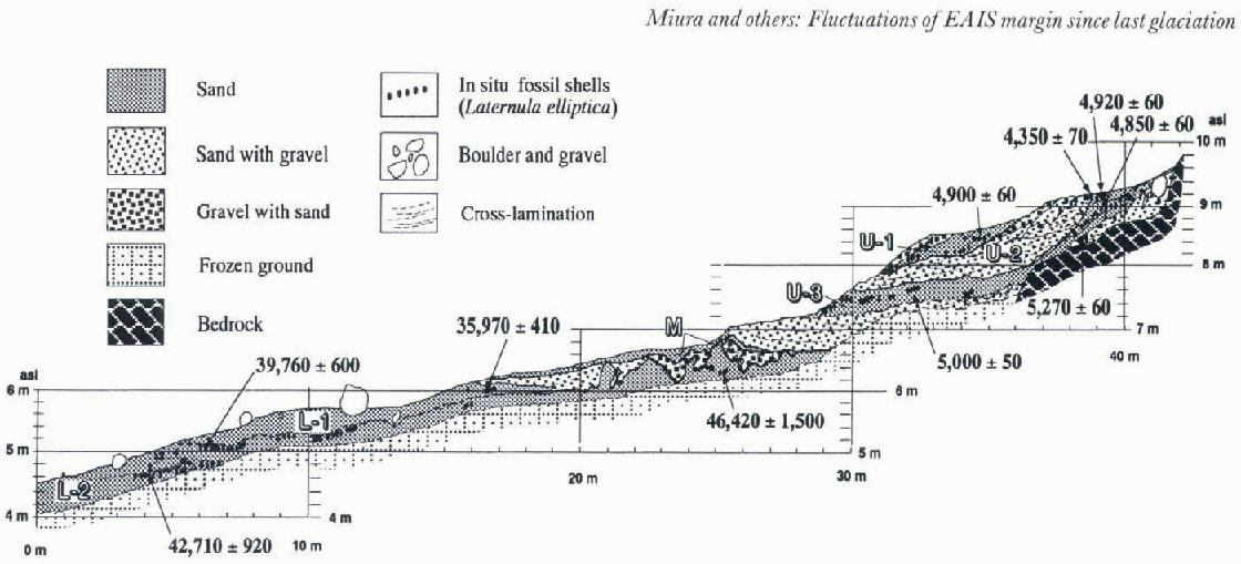
Fig. 3.
Profile of Ε-trench on Kominato-higashi beach. The location is shown in Figure 2. Numbers with arrows indicate radiocarbon dating ages (14C years BP) of in situ fossil shells, calibrated by ![]() corrections but not correctedfor reservoir effect.
corrections but not correctedfor reservoir effect.
3.2. Middle layer
In the Ε-trench, the middle layer (M) overlies part oflower sublayers (L-1 and L-2) with rugged unconformity. It is composed of unfossiliferous cobble- to boulder-size (about 260 mm maximum diameter) subangular gravel. It seems to consist of cut-and-fill deposits, suggesting deposition in a fluvial environment. in W-trench, the middle layer (M) is composed of scattered pebble- to boulder-size (about 600 mm maximum diameter) gravel under the bottom of upper sublayer U-3.
3.3. Upper layer
The upper layer is subdivided into three sublayers (U-1, U-2, U-3). in Ε-trench, the lower part ofU-3 does not yield in situ fossil shells, but reworked shell fragments interstratificd in coarse-grained sand beds with cross-lamination. Pebble- to cobble-size gravels are also scattered in the layer bottom. This part is inferred to have been laid down in very shallow water such as a river mouth. The upper part of U-3 is composed of fine- to medium-grained sand with abundant in situ fossil shells (Laternula elliptica). Several boulders originating from the upper slope are also observed in the fine beach deposits near the bedrock slope. The l4C assay of fossil shells was 4850 ± 60, 4920 ± 60 and 5270 ± 6014C years BP. in W-trench, abundant in situ fossil shells are observed in the sandy layer of U-3. The l4C age of one of the shells indicates an age of4360 ± 70 l4C years BP.
U-2, unconformably overlying U-3, is composed of medium- to coarse-grained sand with granule- to pebble-size gravel. in Ε-trench, the higher part of U-3 is flattened by marine or fluvial abrasion during the period of deposition of bed U-2. The U-2 bed yields only reworked shell fragments in coarse-grained sand beds with cross-lamination. This sublayer probably had been laid down in a river mouth in a similar environment to the lower part of U-3 of Ε-trench. Unsortcd angular to subangular pebble gravels

Table 1. Radiocarbon dales of in situ fossil shells obtained from Kominato-higashi beach
are laid on U-2 with a terrace scarp. in situ fossil shells (Laternula elliptica) occur just below the beach surface which cut obliquely through the sediment layers with a shell dated 4350 ± 70 l4C years BP. This is younger than fossils yielded by the U-1 layer (see below). in W-trench, the lower part of U-2 does not yield in situ fossils, but reworked shell fragments interbedded in coarse-grained sand and gravel layers with cross-lamination. This part is also regarded as having been laid down in a fluvial environment such as a river mouth. Other parts of U-2 contain abundant in situ fossil shells, two of which were dated at 4090 ± 80 and 4060 ± 6014C years BP.
The uppermost sublayer (U-1) is composed of medium-grained sand with granule- to pebble-size gravel, and in-cludes in situ fossil shells of Laternula elliptica . in E-trench, an unsorted angular to subangular pebble gravel is laid on U-1 and forms a terrace scarp. One of the in situ fossil shells was dated 4900 ± 60 l4C years BP. This 14C age is inconsistent with the stratigraphy of U-1 and U-2. The lower part of U-1 in W-trench scoured the upper pari of U-2, and yields only reworked shell fragments included in coarse-grained sand and gravel layers with cross-lamination. On the other hand, the upper part of U-1 includes in situ fossil shells, and one of them was dated at 4050 ± 8014C years BP.
4. Discussion
4.1. Relative Change of Sea Level and Fluvial Activity Since The Last Glaciation
Several l4C ages from fossil shells have been obtained by previous studies of beach deposits on the Soya Coast. These radiocarbon dates have been classified into two groups: one is postglaciol in age between 1 and 10 ka, and the other is 22-34 ka or more (Hayashi and Yoshida, 1994). Recently, using the TAMS 14C dating method for the fossil shells, Igarashi and others (1995) showed that their ages also clearly fell into t wo groups: the younger group is 3 8 ka and the older is 33-42 ka without the ![]() and reservoir corrections. However, it was difficult to distinguish the younger fossils from the older ones on the surface, and to differentiate sea level accurately.
and reservoir corrections. However, it was difficult to distinguish the younger fossils from the older ones on the surface, and to differentiate sea level accurately.
From stratigraphical observations in this study, the lower layers of marine sediments are subdivided by their facies into sublayers (L-1 and L-2) that are composed of beach sand including in situ fossil shells of Laternula elliptica. 14C ages of these fossils ranged from 46420 ± 1500 to 39 440 ± 58014C years BP (L-1) and from 35760 ± 600 to 32430 ± 270 l4C years BP (L-2), from bottom to top of the lower layers. Such progressive decrease of radiocarbon ages suggests the occurrence of a transgression and marine deposition during the last interstadial or Last Intcrglaciol, since a 14C age measured as older than 40 ka has a true age older than the measured age. The upper level of L-1, about 7 m a.s.L, indicates the lower limit of relative sea level at that time without consideration for crustal uplift. Its highest altitude was estimated to be more than 7 m a.s.L, indicated by the upper level of L-2.
The upper layers of marine sediments (U-l, U-2, U-3) are composed of fine marine sand with interbedded coarse deltaic sand and gravel. in situ fossil shells of Laternula elliptica occurred in the marine sand layer and partially in the deltaic sediments. The deltaic also included reworked shell fragments. The 14C ages of the in situ shells ranged from 5270 ± 60 to 4050 ± 80 l4C years BP. The upper layer clearly indicates Holocene transgression around 5 ka14C age. Interbedded deltaic sediments with reworked shell fragments suggest that minor regression(s) occurred during the Holocene transgression. The highest Holocene sea level was estimated at more than 9.6 m a.s.l., which is indicated by the upper level of U-3 at E-trench.
The higher part of the lower marine layers (L-1 and L-2) was eroded and filled by a fluvial process that formed small channels on the lower layers, with overlying fluvial sediments composed of coarse sand and gravel. The fluvial process appears to have been stronger than at present, since the present meltwater cannot transport gravels in the area. These erosion and filling processes may have occurred in a still low-stand sea-level period during the Laie Glaciol and postglaciol before 5.3 ka.
4.2. Ice-sheet fluctuation since the last glaciation
The extremely fragile shells of Laternula elliptica (dated in the interstadial and Holocene) remain in situ, indicating that they have never been disturbed by ice-sheet loading and scouring. This suggests that the EAIS had retreated from the northern part of Langhovde, probably the northern Sôya Coast, prior to the LGM and has not readvanced over the northern part of Langhovde. Wc also obtained the 14C age of the in situ Laternula elliptica included in the raised beach on the Ongul Islands, about 20 km north of Kominato-higashi beach (Fig. 1): this was 30-44ka (Igarashi and others, 1995 and unpublished data), and the EAIS has probably not readvanced over the northern Sôya Coast since that time.
Evidence on ice-sheet retreat and readvanee from late Pleistocene to Holocene has been reported from other areas along the East Antarctic margin. Vestfold and Bunger Hills were deglaciated after 10 000 C years BP and complete by 6000 14C years BP (Colhoun, 1991; Gore and others, 1996), Lar-sen Hills were deglaciated by less than 10 00014C years BP (Burgess and others, 1994) and Windmill Islands were de-glaciated by 5500-800014Cyears BP and readvanced after 400014C years BP (Goodwin, 1993, 1996), so that these areas may not have been overridden by Last Glaciol ice. Although, at this stage, we cannot know the deglaciated age and the location of the ice-sheet margin during the LGM and the evidence of Holocene readvanee, the 14C dating ages of in situ fossil shells indicate that the last déglaciation on the northern Sôya Coast was earlier than in other East Antarctic margin areas.
5. Conclusions
Detailed description of strat igraphy and TAMS 14C ages of raised beach sediments on the northern Sôya Coast indicate that: (1) two transgressions have occurred during the last interstadial or the Last Interglaciol and Holocene; (2) fluvial processes were more active before the 5 ka transgression than at present; and (3) the EAIS retreated from the northern Sôya Coast prior to the LGM, at least from the northern part of Langhovde. These data suggest that the ice extent of East Antarctica during the LGM was less than the CLIMAP model expansion of about 60-80 km offshore for the Sôya Coast, proposed by Stuiver and others (1981) but agrees with the lesser model of East Antarctic glaciation during the LGM of Colhoun and others (1992).
Acknowledgements
We are grateful to all members of the 37th Japanese Antarctic Research Kxpedition (JARE-37), led by Y. Fuji i and H. Kanda of the National Institute of Polar Research, Tokyo, for their help. The manuscript was improved by thorough and helpful comments from the reviewers, E. A. Colhoun and P. A. Berkman, and from the editor, I. D. Goodwin. Part of this work was financially supported by a grant-in-aid (08680192) for scientific research from the Ministry of Education, Science and Culture, Japan.