


1. Introduction
The Sea of Okhotsk is located in the most southerly region of the Northern Hemisphere in which sea ice exists during winter. Since the area and volume of sea ice in this region are related to climate change locally as well as globally (Reference Nishio and AotaNishio and Aota, 1993), it is important to develop methods for monitoring sea-ice parameters around this region. Currently, we are analyzing sea-ice characteristics and developing monitoring algorithms using synthetic aperture radar (SAR) on board the Japanese Earth Resources Satellite CJERS-1), European Remote-sensing Satellites 1 and 2 (ERS-1/-2) (Reference Wakabayashi and NishioWakabayashi and Nishio, 1996) and RADAR-SAT. We plan to apply the developed algorithms on a routine basis in the future. We are also preparing to use fully polarimetric SAR data from future space-borne SARs, such as RADARSAT-2 and the Advanced Land Observing Satellite (ALOS).
In order to gather data for sea-ice monitoring in the Sea of Okhotsk, we have acquired ground-truth data at Lake Saroma, northeast Hokkaido, Japan, and its surrounding area since 1993. The polarimetric and interferometric SAR (Pi-SAR), the dual-frequency, fully polarimetric airborne SAR system developed by the National Space Development Agency of Japan (NASDA) and the Communications Research Laboratory (CRL), acquired the data in 1999 simultaneously with ground experiments. NASDA plans to use the Pi-SAR L-band system to calibrate and validate future space-borne SAR systems, such as the Phased Array-type L-band SAR (PALSAR) on board ALOS.
Polarimetric SAR changes the polarization of its transmitted signal pulse-by-pulse to either linear horizontal or linear vertical, and then receives two differently polarized signals simultaneously. Therefore, it can acquire four polarimetric combinations, HH, VV, HV and VH. Polarimetric SAR data are generally considered to contain much more information on scattering characteristics of the targets than the single-polarization SAR data. For example, the co-polanzation dataset, HH and VV, has surface scattering information, and the cross-polarization dataset, HV and VH, has volume-scattering information.
This paper describes the preliminary results of polarimetric data analysis of typical sea ice observed in the offshore region near Lake Saroma.
2. Test Site
Figure 1 shows our test site including Lake Saroma and its surrounding area observed by Pi-SAR and RADARSATon 23 February 1999. RADARSAT acquired the data in an ascending orbit. Pi-SAR was operated simultaneously with RADARSAT data acquisition. Lake Saroma was fully covered by ice with a relatively smooth surface. We use Lake Saroma as the ground-truth site because it is a salt-water lake connected to the Sea of Okhotsk through two channels, so the covering ice has almost the same salinity as sea ice in the open sea. We measured ice thickness, bulk salinity and surface roughness at 25 points on the lake. We also have several ice-thickness data measured from ship at the offshore region near Abashiri. This paper focuses on sea ice in the southern Sea of Okhotsk in mid-February 1999. Using the ground-truth data we have acquired on Lake Saroma and its surrounding area during the past several years, we found that the snow on the ice is dry and that the mean salinity of the snow-ice interface was around 8 ppt. The maximum snow depth is 15 cm and the ice thickness is 70 cm (Reference Wakabayashi and NishioWakabayashi and Nishio, 1996).

Fig. 1. Example of images acquired by radarsatand pi-sar over the test site.
3. Pi-SAR L-Band System
3.1. L-band system characteristics
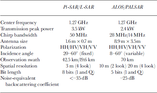
The basic characteristics of the Pi-SAR L-band system are compared with those of the PALSAR system in Table 1. In order to use this system for calibrating and validating PALSAR, the center frequency and range of observing incidence angles were taken to be almost the same as for the PALSAR system. However, radiometric and geometric characteristics, such as noise-equivalent backscattering coefficient and spatial resolution, were designed to outperform the PALSAR system.
Table 1. Pi-sar l-band system characteristics compared with satellite-borne palsar system
3.2. Calibration procedure
Several calibration methods have been proposed for existing polarimetric SAR data, such as the Jet Propulsion Laboratory’s (JPL, Pasadena, CA, U.S.A.) AIRSAR and SIR-C data (Reference Freeman, Shen and WernerFreeman and others, 1990; Reference Van ZylVan Zyl, 1990; Reference Sarabandi, Pierce and UlabySarabandi and others, 1992). In general, cross-talk between the H and V channels is a function of incidence angle. When methods to estimate cross-talk parameters from the images of man-made targets, such as a transponder or a corner reflector, are applied, we need to deploy many reflectors along the cross-track line to cover the whole range of incidence angles. This could be difficult if only a small calibration site is available. In addition, our Pi-SAR L-band system is considered to be a reciprocal system. Therefore, we use a natural target to estimate cross-talk parameters (Reference Van ZylVan Zyl, 1990).
Taking z as an observed scattering matrix and s as a scattering matrix of the target, the relation between the two matrices is as follows:
where a is an absolute calibration coefficient, 4> is the phase related to the propagation distance between SAR and the target, r and t are matrices that represent the radar polarimetric characteristics for receive and transmit, δ1 and δ2 are cross-talk parameters, / is the gain imbalance between HH and VVchannels, and n is the noise matrix in each channel.
When the noise term in Equation (1) is neglected, the scattering matrix of the observed target is derived as follows:
The following is the procedure we adopted before the data analysis.
-
(a) Gross-talk parameters are determined with an iterative method using data from natural targets having no correlation between like and cross-channels.
-
(b) The gain imbalance is estimated by observing the trihedral corner reflectors.
-
(c) The absolute calibration coefficient is derived from the theoretical cross-sections of the corner reflectors.
The natural targets that satisfy condition (a) are considered to be an azimuthally symmetric target for which the dominant scatterer is surface scattering. We believe that salty first-year sea ice satisfies the above condition, because it has relatively high salinity and its surface roughness has no azimuth orientation dependency.
3.3. Calibration results
Since the backscattering coefficient of smooth, salt-water ice is considered to be small, a high signal-to-clutter ratio for reflectors could be expected. In this experiment, we deployed six corner reflectors on the ice cover in Lake Saroma. The rectangular trihedral corner reflectors with leg lengths of 60 and 85 cm were used to estimate the gain imbalance and absolute calibration coefficient, and 80 cm dihedral corner reflectors were used to check polarization signatures. Figure 2 presents a zoomed image around the area where we deployed the corner reflectors.

Fig. 2. Example of corner reflectors deployed on lake saroma.
The procedure described in the previous section was applied to the image over Lake Saroma and the target sea-ice area. Cross-talk was estimated by using the homogeneous area in each image, and the gain imbalance was estimated at the peak of each trihedral reflector. The values from four trihedral reflectors were averaged. After calculating the target scattering matrix by substituting the estimated parameters into Equation (2), we calculated an absolute calibration coefficient using the integration method (Reference Gray, Vachon, Livingstone and LukowskiGray and others, 1990). The accuracy of the estimated calibration factor is within 1.1 dB for all reflectors (Reference Wakabayashi, Kobayashi, Satake and UratsukaWakabayashi and others, 1999).
4. Polarimetric Data Analysis of the Sea Ice
Reference Rignot and DrinkwaterRignot and Drinkwater (1994) analyzed L- and G-band polarimetnc data acquired byJPL AIRSAR covering the Beaufort Sea in 1988 and found that the dual-frequency single-polarization data classify sea ice more accurately than the single-frequency dual-polarization data. Reference Winebrenner, Farmer and JoughinWinebrenner and others (1995) used the same dataset and found that the co-polarization ratio and phase were related to ice thickness. Reference Nghiem, Kwok, Yueh and DrinkwaterNghiem and others (1995a, b) created a polarimetnc signature model for sea ice and tried to explain the backscattering coefficients from multi-year ice, first-year ice and thin ice in leads in the Beaufort Sea. As an example of SIR-G L-band polarimetnc data, Reference Eriksson, Drinkwater, Holt, Valjavek and NortierEriksson and others (1998) analyzed the first-year ice in the eastern Weddell Sea, Antarctica, and found that the correlation coefficient between HH and VV combined with VV backscattering coefficient could achieve higher classification accuracy.
Reference Barber and NghiemBarber and Nghiem (1999) reported that the thermodynamic structure of the snow-ice boundary, relating to the dielectric-constant changes in the snow basal layer and ice surface layer, affected the C-band backscattering coefficient during the melting period. However, since we acquired L-band data in February, we believed that the dominant scattering mechanism of the winter sea ice in this region was the ice surface scattering (Reference Wakabayashi and NishioWakabayashi and Nishio, 1996).
Sea ice in the area of interest shown in Figure 1 was classified into four categories based on the backscattering coefficient in C-band of RADARSAT and L- and X-bands of Pi-SAR data (Matsuoka and others, in press). The four categories were thin ice (TI), smooth first-year ice (SFI), rough first-year ice (RFI) and open water (OW). In Figure 3, rectangles indicate the sampling points from the four categories. Using the results of the previous work, we focused on analyzing the correlation coefficient and the phase difference between HH and VV. We also analyzed the correlation coefficient and the phase difference between RR and LL, which were calculated from the polarization synthesis and contained cross-polarization information.

Fig. 3. Evaluated points offour categories in the area of interest are plotted on the pi-sar l-band total power image. the size of this area is 4 km by 4 km.
Although the previous work indicated that the co-polarization ratio yielded information related to ice thickness, we could not get any valuable results in this time, probably because the data analyzed were acquired at a relatively small incidence angle.
By taking ρppqq and ϕppqq as the correlation coefficient and phase difference between PP and qq polarizations, these values are calculated from the scattering matrix as follows:
where spp and sqq are the elements of the scattering matrix, and <) indicates the ensemble average.
PHHVV is the correlation coefficient between the HH and VVchannels. In general, ρHHVV approaches 1 if the dominant scatter is surface scattering. φHHVV is the phase difference between HH and VVchannels, and approaches 0 for surface scattering. We also analyzed ρRRLL and φRRLL, which are calculated by polarimetric synthesis.
Figure 4 shows cross-plots of correlation coefficients and phase differences from the sampling points in Figure 3. From these plots we can conclude the following:
-
(1) The difference of ρHHVV between SFI and RFI is very small, ρHHVV of TI has smaller values than for the other three categories.
-
(2) ρRRLL decreases in the order TI, SFI and RFI. We can separate three ice types using ρRRLL.
-
(3) φHHVV and 0RRLL provide less information regarding ice types and discrimination between ice and water.
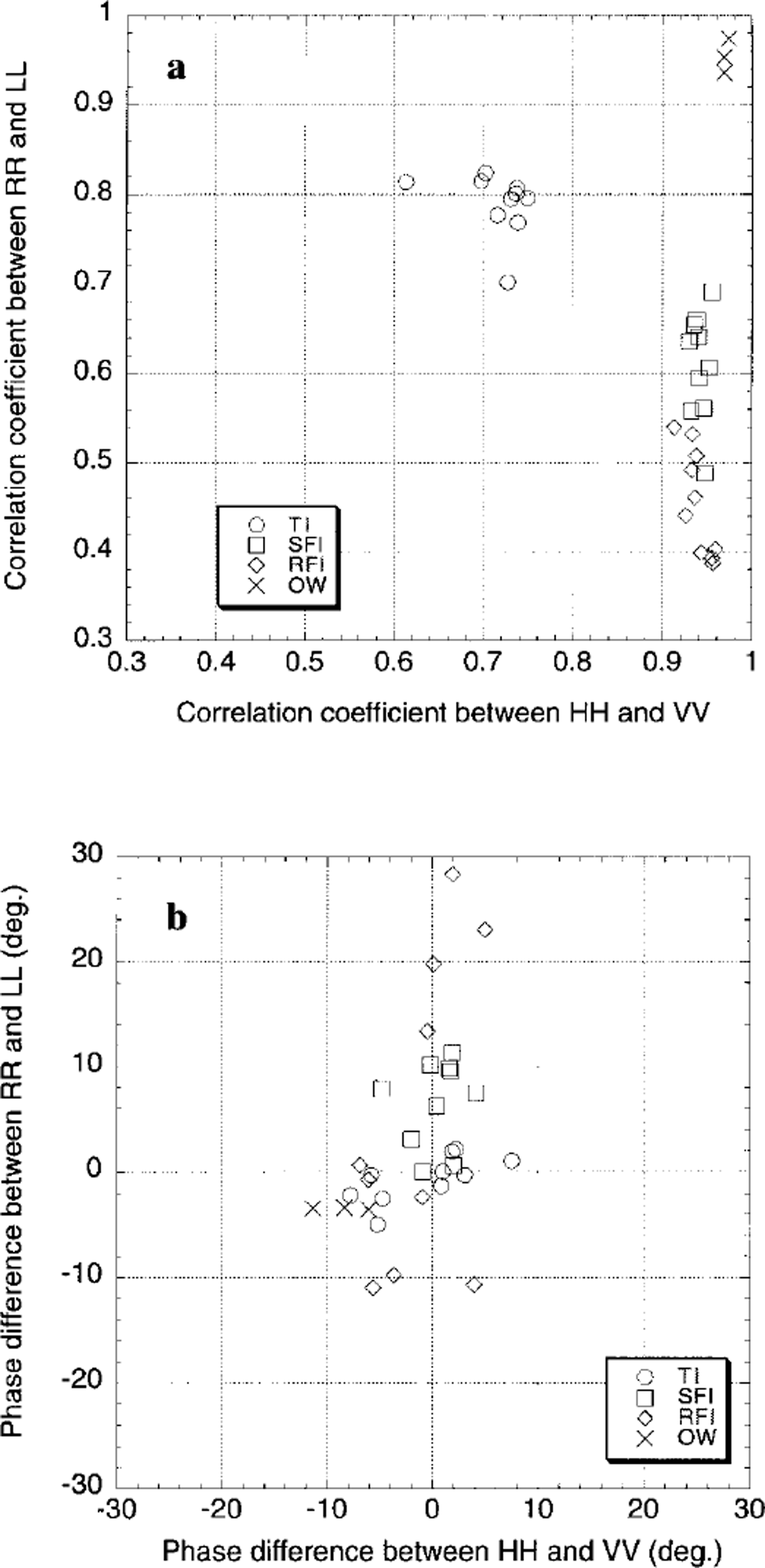
Fig. 4. Polarimetnc characteristics of typical ice. (a) correlation coefficient; (b) phase difference.
We also analyzed the incidence-angle dependency on correlation coefficients and phase differences. Although the incidence angle in Figure 3 ranged from 21° to 36°, little angle dependency was found.
It was reported that ρRRLL was sensitive to surface roughness of the soil and could be used to retrieve roughness parameters for pre-processing the soil-moisture estimation (Reference MattiaMattia and others, 1997). Since the surface roughnesses of three ice types seem to have different characteristics, we may conclude that ρRRLL is a good indicator for describing surface roughness of salty first-year ice.
5. Conclusion
By using L-band SAR data acquired by Pi-SAR, we performed polarimetric analysis of sea ice observed in the Sea of Okhotsk. The polarimetric parameters used were correlation coefficient and phase difference. Based on the analysis of these parameters, we found that the correlation coefficient between RR and LL polarizations enables us to discriminate four categories including three types of ice and open water.
In order to derive a method to estimate surface roughness parameters of sea ice, it is necessary to compare ρRRLL with the measured surface roughness as a next step.
Acknowledgements
The authors are grateful to the students of Hokkaido University of Education for their help in acquiring the ground-truth data as well as deploying corner reflectors.


