
Introduction
The renowned Eurasian specialist Owen Lattimore (1900–1989) draws a remarkable distinction between a frontier and a boundary. In his celebrated study Inner Asian Frontiers of China, he explains that a boundary represents the intended limit of political power, “the farthest extent to which a state or empire is able to exert its will on geographical space,” whereas a frontier is a zone of active interaction that “exists on both sides of the boundaries.”Footnote 1 Within any frontier region, distinct communities of “boundary-crossers” can be identified as those who transgress the physical borders of polities and environments, and the sociological borders of ethnic, religious, and language groups.Footnote 2 It is also a zone of contention across which competing ideas of civilization converge and conflict. It has been argued that the borderlands between the core of China and the farthest nomadic pastures were a zone of frontier interaction, a ‘middle ground’ where peoples following radically different ways of life adapted to one another and to their surroundings. Extending this concept, I suggest that a frontier is a multilayered transcultural region that can be understood in both physical and cultural terms. Physically, a frontier refers to a landscape or seascape that is shaped by a number of geological, ecological, and/or cosmological factors. Culturally, a frontier is a product of the various ways in which certain groups of people conceptualize and model any given space. People carrying a particular or multiple sociopolitical backgrounds (such as emperors, government officials, traders, seamen, educated elites, and pirates) in a specific time–space and context will generally construe the character and significance of a particular frontier in diverse ways. One may conceptualize it as a depiction of interactions, a cosmopolitan gateway for the import and export of goods and ideas and the movement of people, or as a barricade that divides civilizations. Either directly or indirectly, different conceptualizations of frontiers will shape trade, diplomatic strategies, political dynamism, and the identity and consciousness of nations. Being a contact zone, a frontier is tied to the interactions and antagonisms between two separate parts and/or opposing forces. The classic form of this is when more “civilized” and economically superior powers subordinate what they consider to be “barbaric” and inferior populations (as in the legendary cases of Captain Cook in Hawaii or Commodore Perry in Japan).
As mediums of social interaction and movement among people who transmit goods, technologies, fashions, and ideas, oceans sensibly form a frontier that facilitates sociopolitical and cultural development across different realms of space.Footnote 3 In the era of the empire, however, maritime frontiers stood apart from all other frontiers. Transportation across sea frontiers incurred significantly lower costs than it did on land. Travel by sea in the premodern period was usually “cheaper in human terms.”Footnote 4 Incidental hazards of negotiation, protection money, willful obstruction, and downright violence at sea were much rarer than when carrying goods by land from region to region and from one settlement to another.Footnote 5 Sea travel was also cheaper because of its low energy and technology requirements. Even before the steamship age (c.1840s), sea traffic was far more cost-effective than overland trade. Indeed, it has been estimated that the same amount of energy would move 250 kilogrammes of goods on carriages, 2,500 kilogrammes by rail, and 25,000 kilogrammes by water.Footnote 6 Also, it has been broadly calculated that one dhow could travel the same distance as a camel caravan in one-third the time, and that each vessel could carry the equivalent of 1,000 camel loads. Furthermore, only one dhow crewmember was needed for several tons of cargo, as compared with two or probably more men for each ton transported in a camel caravan.Footnote 7
Sea transport as such was plausibly the most cost-effective means of moving people and goods before the age of air transportation.Footnote 8 From the fifteenth century onward, cross-border shipping experienced stunning growth in both scale and complexity.Footnote 9 Western Europeans were the first to cross the boundaries of the known Old World and extend their reach into the so-called “New World.” Between the seventeenth and the eighteenth centuries,Footnote 10 European sea traders expanded their shipping routes across the Atlantic to America and Africa, and across the Indian Ocean to India, Southeast Asia, and the Far East. A large volume of consumer commodities, including sugar (from the West Indies), coffee (from Latin and South America), tea (from China), tobacco (from Virginia), fish (from Newfoundland), and spices (from the East Indies) flowed steadily and continuously to Europe from different corners of the world.Footnote 11 By the end of the Napoleonic Wars, commerce and cultural interactions across the oceans were much more globally connected than in previous decades. The eighteenth and nineteenth centuries represented a decisive turning point in the history of globalization, with the evolution of the world system and, in particular, the use of the oceans.Footnote 12
Although oceans were understood, in the twentieth century, as transnational water frontiers fostering the “global flow of commodities and ideas,”Footnote 13 the question remains whether the Qing court, in the long eighteenth century, also conceptualized the oceans as contact zones where international trade and cultural interactions could be forged. If it did not, then how did the visions of Qing monarchs differ from those in the West? How did the Qing governing body model the ocean and its maritime frontier at a time of frequent and vibrant transoceanic interaction? Before moving into a discussion of this matter, an understanding of the “deep structure”Footnote 14 of the East Asian Sea, including its geographical boundaries, climatology, and topography, will effectively set up the background context for the reader and elucidate the scope of this study.
Geography and Ecology
The so-called “ancient” division of the Earth’s landmasses and sea spaces are, to a substantial extent, recent social constructions of physical spaces that are imprecise and full of biases.Footnote 15 However, these geographical divisions and territorial claims also provide a useful framework for exploring geography across the globe, and for understanding historical junctures, developmental patterns, and even contemporary proceedings.Footnote 16 For this study, in particular, looking at the world geographically provides a useful context in which to investigate the land, water, and people in East Asia. It also inspires us to ask some straightforward, plain-sailing questions regarding the study of maritime Asia, such as what is the (East) Asian Sea? And where is it?
The East Asian Sea is a vast body of water that covers a significant part of the world’s maritime surfaces (the East China Sea, 1,249,000 square kilometers; the South China Sea, 3,500,000 square kilometers; Bohai Sea 78,000 square kilometers; and the Sea of Japan 1,300,000 square kilometers). Its average depth is about 3,478 feet (1,060 meters). The deepest part is called the China Sea Basin, which has a maximum depth of 16,457 feet (5,016 meters).Footnote 17 A broad shallow shelf extends up to 150 miles (240 kilometers) in width between the mainland and the northwestern side of the basin and includes the Gulf of Tonkin and the Taiwan Strait. To the south, off southern Vietnam, the shelf narrows and connects with the Sundra Shelf, one of the largest sea shelves in the world. It covers the area between Borneo, Sumatra, and Malaysia, including the southern portion of the South China Sea.
In his Records of Sea Travels (Hanghai shuji), Zheng Deyi (1847–1918), a native of Fujian, recounted the sea as being “enormously huge” (gai haiyang zhi da) and “without a limit” (tianshui wuya) and asserted the impossibility of grasping its full extent.Footnote 18 In a similar fashion, Qian Cai also has this to say: “we cannot locate the other side of the gigantic ocean, just like we are not able to reach the limit of the sky” (mangmang dahai wu bianan, miaomiao tianya wu jintou).Footnote 19 In his distinguished geopolitical record, Shuofang beicheng, the experienced Qing traveler He Qiutao (1824–1862) also considered the sea “wide and never-ending” (haiyang guangda).Footnote 20 Likewise, in his Study of Eastern and Western Seas (Dongxiyang kao), Zhang Xie wrote, “once out of Moon harbor … there are no coastlines to follow, no villages to note, and no courier stages to tick off.”Footnote 21 These writers were fairly precise in suggesting that it was almost impossible to know the seemingly limitless contours of the ocean during their time, even though the Ming Dynasty had developed a number of sailing techniques that would possibly provide those writers more detailed information to survey the ocean.Footnote 22 In fact, today, even when using contemporary topographic measurements, it is complicated to establish the full extent of the oceans. According to the United Nations Oceans Atlas and the International Hydrographic Organization, the two leading entities concerned with maritime geography, the longitudes of the East Asian Sea are roughly 120° E to 140° E. If we include the Sea of Japan, this would make Sakhalin Island, broadly speaking, its northern limit. From there, we go around the coast, passing through the gulf between the Korean peninsula and Shikoku, past the Yellow Sea, the East China Sea and the South China Sea, to what is geographically the southern limit at the Malay peninsula and the greater Sunda Islands of the Indonesian archipelago.
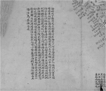
Other international geographical organizations may incorporate waters passing north of Australia, around the Arafura Sea and Arnhem Land, Mackay, Brisbane, the east coast of Tasmania, and then down to Antarctica. However, this is far too much of a stretch, especially given Alan Villiers’s (1903–1982) explication of geopolitical congruency.Footnote 23 In his book The Western Ocean: The Story of the North Atlantic, Villiers addresses how geopolitics asymmetrically conditions trade, empire, and populations in the north and south Atlantic.Footnote 24 Villiers’s apt contention is also applicable to the maritime seascape of East Asia and the high Qing authority in that the intricacies of a particular coastline, the distribution of the islands proximal to it, its variety of marine resources, and the locations of its port cities can shape not only the patterns of the regime’s shipping circuits, fisheries, and piracy, but also its maritime strategy. For instance, the Kangxi bureaucracy continued to refine the blueprint for the empire’s coastal administration. The emperor regularly ordered government officials to “scale the mountains and navigate the littorals” in Shandong, Jiangsu, Zhejiang, Fujian, and Guangdong. Soon after their surveys were completed, officials submitted memorials to the emperor, providing detailed analysis for harnessing the nation’s variable seascape. Kangxi’s grandson Qianlong even launched a series of “grand projects” to thoroughly examine the coastline in order to put his maritime policies into practice. As a result, precise sea charts were officially produced throughout the long eighteenth century. Examples, such as Qisheng yanhai quantu (A Complete Maritime Map of the Seven Provinces), Haijiang yangjie xingshitu (A Strategic Map of the Maritime Frontier), and the reproduction of the Wanli haifang tushou (A Map of the Maritime Frontier) first published in the Ming are all maritime diagrams (haitu) composed by scholarly officials and geographers who were under imperial supervision at the time.
These maps served as tools to empirically trace the variations in the empire’s coastline. They also show that few, if any, commercial or maritime activities between Asia (China in particular) and the east coast of Australia had developed by the eighteenth century. So any attempt to include eastern Australia in the East Asian Sea, as some scholars have done, is not very helpful. People who inhabited Australia, over the long eighteenth century, had negligible contact with China, India, and Southeast Asia. It was not until the mid-nineteenth century that Chinese gold seekers began arriving at the Australian gold rushes, while its aboriginal peoples seldom ventured beyond its shallow coastal waters.Footnote 25 Therefore, rather than considering the waves off Australia and Antarctica as part of the scope of this study, I am inclined to stop at the South China Sea and go no further south. One way to visualize the East Asian Sea is to see it as an outstretched belt that embraces East Asia. The starting point is around 50° north latitude and then goes south to the Bohai Sea, the Liaodong peninsula, the Shandong peninsula, Hainan Island, down the east coast of Vietnam, and then down along the coast of Malaysia and the Strait of Malacca.
The topography of the East Asian Sea varies from place to place, being quite different in the more enclosed bays, for example the strategic Bohai Gulf, than in areas of wide open ocean. Some coastal regions along the Russian seaboard have been uninhabited since Neolithic times because they are either uninhabitable or are cut off from the interior by impenetrable mountains.Footnote 26 But most of the shores of the East Asian Sea are not so inhospitable. The coastal fringe on the western shore of the East Asian Sea, close to South Korea, the North China Plain, and the southeastern part of China, is an arguably large, productive, and fertile region. The ancient Chinese had favored this terrestrial plane, for its pleasant environment, since the Warring States period (475 BC–221 BC).Footnote 27 The Koreans and Japanese also found this topography favorable. Even though its high mountain ranges cut through Korea’s two southernmost provinces (Cholla-Namdo and Kyongsang-Namdo) and Japan’s main island (Honshu), none of these landscapes were altogether impassable.Footnote 28
The East Asian Sea also extends into deltas and harbors and has different sea depths and other geological features. By the eighteenth century, or perhaps earlier, Qing leaders and cartographers had noted these variations and tried to explain their causes. For instance, in the Qisheng yanhai tu (a coastal diagram mentioned earlier), the mapmaker succinctly indicates that the sea surrounding northern China is relatively shallow out to the edge of the continental shelf (see Figure 1.1). The seafloor of the continental shelf is composed mostly of sand, silt, and mud from the Yellow River. The mapmaker further described this geographical feature as follows:
The Yellow River delta lies between Haizhou and Miaowan. The greater sea is clearer than the Yellow River in terms of volume of sediment. When sediments of the Yellow River flow into the greater sea, the bottom of the sea is elevated and the seabed structure changes. The depth of the seawater thus becomes shallower. To sail across shallow waters, merchants must sail on sand ships (shachun) constructed in the Jiangnan region. The bottom of a sand ship is flat and smooth so as to enter the northern seawater with less friction. By contrast, merchant vessels, which are constructed in Fujian and called minchuan, usually have difficulty coping with this geography because of their round hull. The best way to sail across this section of seawater is to wait for low tide. The receding tide means that the seawater will become deeper. It is safer to proceed in this circumstance.
This paratext indicates the mapmaker’s familiarity with the topography, sedimentation, and tides of the floor of the Bohai Sea. He provides his readers with an explanation for why the Bohai Sea is shallow and recommends the type of ship sailors should use to navigate the “troubled waters.” He also highlights guidelines for safe sailing. By detailing general information regarding the complicated shoreline, sailing and shipbuilding, the mapmaker may have hoped to aid scholar-officials to better analyze coastal conditions and the empire’s maritime frontier. In this sense, coastal maps, like the Qisheng yanhaitu, also seem to have served to systematize the reader’s strategic and geographical understanding of the coast, rather than simply surveying its intricacies.

Figure 1.1 Part of the Qisheng yanhaitu 七省沿海圖 (A Coastal Map of the Seven Provinces)
Climatology
In the age of oars and wind, weather constrained much, if not all, maritime activity. These factors profoundly influenced ship design; the periodic cycles of sailing routes and seasons; and the state of the fisheries, harbor control, and naval policies. For instance, tidal patterns and the seabed depth influenced the evolution of ship design in both the North Sea and Bohai Sea.Footnote 29 Mariners in the Black Sea had long been warned to pay particular attention to the chokepoint between Cape Sarych, in Crimea, and Cape Kerempe, in Anatolia, because of the sea storms there.Footnote 30 Even very late in the Middle Ages (1031–1350), the formidable ocean currents made it difficult to sail from the Mediterranean Sea to the Atlantic Ocean.Footnote 31 In addition, naval bases were often established in deep-water ports in regions with moderate climates, such as Amoy (Xiamen), Baltimore, Canaveral, Portsmouth, Devonport, and Ryojun. Conditions conducive to good ports include the prevailing wind patterns, the currents and waves, and the coastal topography.
From ancient times to the age of exploration, roughly until the eighteenth century, wind patterns (including scorching winds) and seasonal monsoons decidedly influenced shipping routes and schedules. The wind system truly mattered in premodern maritime shipping. The difference between the seasonal monsoonal patterns and the prevailing winds was especially important, the latter of which were consistent year-round. “Before the age of steam, wind determined what man could do at sea: by comparison, culture, ideas, individual genius or charisma, economic forces, and all the other motors of history meant little.”Footnote 32 The wind system largely regulated when and where people could sail. Through experience, sailors in imperial times learned that the shortest-line distance on sea charts was not necessarily the most expeditious route. Instead, the best route was the one that took advantage of the wind patterns. For instance, the Greeks and the Romans left their ships in port between October and April because of the strong northerly prevailing winds in winter.Footnote 33 In Egypt in the eleventh and twelfth centuries, the sea was closed off from November to March for the same reason.Footnote 34 In the Qing era, most of the officials and mariners also recognized the importance of wind patterns in both short- and long-distance navigation (shun feng xiangsong).Footnote 35
In simple terms, monsoons are generated by the Earth’s rotation, and their strength and speed are governed by the interaction of continental pressure systems and the temperature of the water at the ocean’s surface. The East Asian Sea is affected by the East Asian Monsoonal System (EAMS), which carries moist air from the Indian and the Pacific Oceans to East Asia. The EAMS influences the climates of Japan, Korea, and much of coastal China, and thereby affects approximately one-third of the global population. The EAMS is divided into two seasons: the warm and wet summer monsoon season and the cold and dry winter monsoon. In summer, considerable heat warms the Asian continental landmass. Hot air rises and creates a low-pressure zone. Moisture-laden air from the East Asian Sea then moves into this low-pressure area, rises in the upward-moving air current, cools, and finally forms into clouds that produce rain. The reverse occurs in winter, as the sea cools more slowly than the land, and the offshore winds flow out from China to the East Asian Sea. Because of the EAMS, the monsoons in the East Asian Sea follow a regular pattern: southwest from May to September and northeast from November to March. Similar to the East Asian Sea, the Atlantic Ocean also has predictable year-round trade winds with regular patterns. Yet round-trip sailing has always been much easier along the East Asian Sea than in the Atlantic. In fact, it used to be said that “mariners always have to beg Neptune’s forbearance while they passed through the Atlantic Ocean.”Footnote 36 By contrast, the East Asian Sea offers relatively favorable conditions for shipping, such as clearer skies and warmer temperatures, for many more months of the year. Also because of its relatively smaller size, the East Asian sea rarely generates the huge swells that make the Atlantic Ocean so treacherous to navigate.Footnote 37
The above-mentioned monsoonal patterns highly influenced navigation under oar and sail. The winds and currents made sea travel difficult for medieval and early modern navigators, thus compelling sailors to confine their season to the months when it was possible to sail a relatively calm sea that is backed by suitable wind patterns.Footnote 38 To be more specific, if a sea merchant successfully caught the wind pattern, his expedition would not be overly challenging. Those who ignored the monsoons, or who were ignorant of them, would have difficulty crossing the ocean. For example, if a merchant decided to make his way from Shanghai to Makasar in June via a junk, thereby sailing against the summer monsoon, his voyage would take a minimum of six weeks, a crossing roughly twice as long as it would have been earlier in the season.Footnote 39 Like Asian sailors, Atlantic seamen were also constrained by the Asian Sea’s formidable monsoons. For instance, in early July 1541, a marauding Portuguese vessel departed the Red Sea for India. The ship’s headstrong captain refused to listen to the advice of his experienced Muslim pilots, who told him that no ship could navigate the Arabian Sea without adhering to the trade winds. Of course, that “Muslim advice” turned out to be correct.Footnote 40 Likewise, in 1980, Tim Severin refused to listen to the seamen who had urged him to catch the monsoonal winds when he sailed his dhow on a “Sindbad” voyage from the Persian Gulf to China. Instead, he chose March and April, and got stuck, for thirty-five days, east of Sri Lanka.Footnote 41 These examples show that, despite the existence of unbeatable wind patterns, sailors charted sea passages where the wind was less favorable because they had been drawn in by either commercial or political interests.Footnote 42 Similarly, examples are also identified by some provincial generals and naval commanders in the Qing, as we shall see in Chapter 3. When petty pirates in the South China Sea decided to plunder a village by hit and run, they did not care about the wind pattern. On such occasions, human factors present challenges that are in addition to those posed by the forces of nature.
Apart from the wind patterns, sea voyages in East Asia were conditioned by many other climatic constraints, such as ocean currents and breaking waves. These two geographical factors could also alter how and when one traveled, as well as how and when to patrol. In the most general terms, an ocean current is a continuous directed movement of ocean water that is driven by waves, wind or differences in air pressure. Most sailors understood how these currents affected their ship’s movements. That is, knowledgeable seafarers could choose a faster course by sailing with the current or they could avoid a course that would have them sailing against the current. In other words, ocean currents can either be an opportunity or a problem. Ever since the ninth century BC, the Chinese made use of water currents to speed up their voyages. They learned that sea currents would enable them to sail efficiently, safely, and pleasantly from point to point (renchuan anle, guoyang pingshan, shuang peng gaogua yong wu you).Footnote 43 At the same time, the Greeks also utilized currents for navigation in the Black Sea. If they met an appropriate current pattern, they could travel from Odessa to Istanbul “in only one day, without hoisting a sail.”Footnote 44 Yet water currents can also be problematic. When traveling to the East in the 1270s, Marco Polo (1254–1324) recorded that the Muslim sailors never went south of Madagascar, or even Zanzibar, because of the Lagullas or Agulhas currents. To the Muslims, both currents “would obstruct their way to return to the north.”Footnote 45 The Portuguese Jesuit Jerónimo Lobo (1595–1678) also believed that “if one ignored the impact of water current, things could go badly astray.” When his ship had trouble getting around the Cape of Good Hope, he regretted not keeping closer to land in southeast Africa so he could have made better progress, because “the water current between Madagascar and the East African coast was so strong that it could carry a ship to the south even when the winds were contrary.”Footnote 46
Waves also affected sea voyages. Chinese maritime writers described huge waves and their impact in the South China Sea, though perhaps some of these accounts were slightly exaggerated by overzealous narrators. But it should not be hard to understand that a serious wave could make sea travel and sea patrol difficult and even cause traumatic shipwrecks. A wave pattern could not only obstruct a passage; it could also beat on shorelines and damage poor harbors and littorals. As recorded in the Da Qing Shichao shengxun (The Sacred Instructions of the Ten Reigns) (1616–1874) and the Qing shilu (The Veritable Records of the Qing Dynasty), hydrological disasters generated by strong waves occurred regularly in the reign of Kangxi (1662–1723).Footnote 47 Local gazetteers of coastal provinces recorded that when hit by serious sea waves, some shores in Jiangsu, Fujian, Zhejiang, and Shandong were almost unapproachable by fishing boats and policing vessels.Footnote 48 Tides – the rise and fall of the sea level – are also perilous for sailors in “narrower” seaways, such as the Taiwan Strait.Footnote 49 The effect of a strong tide can be felt a hundred miles up the Fujian coast and into South China’s estuaries and deltas. These incalculable factors presented daunting challenges to officials and mariners who either governed or attempted to venture into the sea.
Concluding Remarks
The “deep structures” of East Asian seas, from climate and topography to currents and winds, have influenced almost all seafaring activities from antiquity to the 1800s. It was not until the very late nineteenth century that the direct influences of these climatic factors became less predominant – as the advent of combustion engines and coal steamers made it easier to overcome the impacts of monsoons, currents, and waves. During the age of the steamship, marine navigation evolved into a fully systematic technique.Footnote 50 The history of the East Asian Sea entered a new chapter, when the “industrialization of ocean passage” dramatically altered its economic and sociological dimensions for the first time.
A variety of climatic factors determined what occurred within the boundaries of the East Asian Sea during the age of sail. Important characteristics such as the “deep structures” of the seas were also determining factors that shaped the routes sailors charted and the maritime policies set up by governments. Indeed, evidence shows that climatic and geographical forces shaped the seascape. And in many cases in China and elsewhere, rulers, sailors, and sea merchants had to adjust to all of these climatic flows. However, it is imperative to note that the sea space could be shaped by human hands at many levels. This sea space could be conceptually modeled by a group of intellectuals, with little, if any, experience going aboard and only a very limited knowledge of the waves and the winds and their impact on navigation. Regarding the naval setting along the coast of China, the reason why some of these port cities were strategically important depended, to a significant extent, on other factors and limitations in addition to the wind and the waves. In other words, it must be emphasized that the East Asian Sea, like many other maritime spaces, was constantly shaped by both human and non-human factors.Footnote 51 While those non-human elements were instrumental in molding the natural history of the watery plain, in Chapter 2, we will see that on some occasions, over the long course of history, the human hand has also been a significant factor in shaping the East Asian Sea.