


Introduction
When Homo sapiens dispersed from Eurasia to the Pacific they moved through the islands of Wallacea to reach Sahul (the Pleistocene continent connecting New Guinea with Australia) (Figure 1). To facilitate these journeys, humans devised seafaring technologies and crossed several biogeographic thresholds, pushing beyond the Afro-Eurasian landmass for the first time into increasingly small and faunally depauperate islands (O'Connell & Allen Reference O'Connell and Allen2015; Shipton et al. Reference Shipton, O'Connor and Kealy2021). These dispersals encouraged major behavioural adaptations—not seen among other hominin species such as Homo erectus, Homo floresiensis and Homo luzonensis—as our species learned to live among, and transform, these tropical islands (O'Connor et al. Reference O'Connor, Louys, Kealy and Carro2017; Gaffney Reference Gaffney2022). The timing and route of these movements remain unresolved and highly contested (Kealy et al. Reference Kealy, Louys and O'Connor2018; Norman et al. Reference Norman, Inglis, Clarkson, Faith, Shulmeister and Harris2018; Bird et al. Reference Bird2019; Bradshaw et al. Reference Bradshaw2019; Allen & O'Connell Reference Allen and O'Connell2020).

Figure 1. Northern and southern routes through Wallacea, showing Mololo Cave on Waitanta. Inset A) seafaring simulations and chance of successful landing on Waitanta from nearby landmasses, based on averages taken from 1.5kt paddling at -30m and -50m sea levels (Table S6); Inset B) Waitanta shoreline and Mololo Cave at 50 000 years ago and at the Last Glacial Maximum (20 000 years ago) based on multibeam and GEBCO bathymetry data (figure by authors).
Archaeological evidence from Madjedbebe, a rockshelter in Arnhem Land, northern Australia, suggests that humans initially arrived in Sahul via a southern route that included the Lesser Sunda Islands, around 65–60ka (thousand years ago) (Clarkson et al. Reference Clarkson2017). Along the southern route, evidence of H. sapiens at Liang Bua (Flores Island), Makpan (Alor) and Laili, Asitau Kuru and Lene Hara (Timor), however, stands at maximally 44ka (Hawkins et al. Reference Hawkins2017; Sutikna et al. Reference Sutikna2018; Shipton et al. Reference Shipton, O'Connor, Jankowski, O'Connor-Veth, Maloney, Kealy and Boulanger2019; Kealy et al. Reference Kealy2020). This disparity has led some archaeologists to argue that the northern Australian dates are erroneous and that a later arrival to Sahul after 50ka, also involving a northern equatorial route, is more convincing (O'Connell et al. Reference O'Connell2018). Although cave art from the Maros Karst sites (Sulawesi) (Brumm et al. Reference Brumm2021) and Lubang Jeriji Saléh (Borneo) (Aubert et al. Reference Aubert2018) include figurative hunting scenes that date to at least 45ka, the earliest sites along the small islands of the northern island chain—Golo (Gebe Island), Liang Lemdubu (Aru Islands) and Liang Sarru (Talaud Islands)—date to less than 40ka (Tanudirjo Reference Tanudirjo2001; O'Connor et al. Reference O'Connor, Aplin, Szabó, Pasveer, Veth, Spriggs, O'Connor, Spriggs and Veth2005; Bellwood et al. Reference Bellwood, Irwin, Tanudirjo, Nitihaminoto, Siswanto, Bowdery and Bellwood2019a). Determining the nature of H. sapiens migrations to the Pacific is crucial for understanding how our species diversified outside of Africa, adapted to the challenges and opportunities of these novel environments, including insularity and tropical forest cover, and interacted with other hominin species present in the region. Northern dispersals may have brought H. sapiens into close contact with Denisovan hominins, perhaps present around Sulawesi (Carlhoff et al. Reference Carlhoff2021), or Homo luzonensis in the Philippines (Détroit et al. Reference Détroit2019), while southern movements may have seen our species cohabit islands, however briefly, with Homo floresiensis (Sutikna et al. Reference Sutikna2016).
Here, we report the first excavations from the Raja Ampat Islands, off the north-west coast of New Guinea, a key island group along the ‘northern route’ to Sahul. We first provide bathymetric (ocean floor depth) reconstructions of island size and voyage simulations for the northern entry to Sahul, and then detail excavations, radiometric dating and multidisciplinary archaeological and palaeoecological analyses at the site of Mololo Cave on Waigeo Island to clarify when and how humans moved along the northern route into Sahul, prior to 50ka.
Coastline reconstruction and seafaring modelling
From 65–50ka, eustatic sea level fluctuated between approximately 30–50m below present levels (Kealy et al. Reference Kealy, Louys and O'Connor2017). Multibeam imagery demonstrates that Waigeo and Batanta islands were, at times, connected by a shallow platform (Figures 1B & S1, see also online supplementary material (OSM)). We call this palaeo-island Waitanta (wai = water, tanta = that extends in front of your eyes). This island was separated from Sahul by the deep Sagewin Strait throughout the Pleistocene, even during the Last Glacial Maximum (LGM). As such, humans would have needed watercraft to move between Waitanta and Sahul. At 50ka, the Sagewin Strait was 5–6km wide on average and 2.5km at its minimal distance, and at the LGM the average width was about 5km with a minimal crossing distance of 1.5km.
Our novel seafaring simulations show that eastward-moving crossings were most easily achieved between Obi–Kofiau–Waitanta, even with minimal propulsion (Figures 1A & S2, Tables S1–S9, see OSM for simulation methods and results). Successful arrivals on Waitanta by paddling at 1.5kt (0.77m/s) were nearly guaranteed when moving from Kofiau, Gebe and Halmahera in the west or Sahul in the east. Trips from Sahul would be quickest, followed by Gebe, Kofiau and Halmahera, lasting 2–3 days. Crossings from Talaud and Morotai to the north were highly unlikely. Even in suboptimal weather, movements between Waitanta and Sahul across the Sagewin Strait were safe for rafts paddled at 1.5kt but were also possible with slower paddling during ideal conditions (Table S10).
Mololo Cave excavations and chronostratigraphy
Mololo Cave (0°18′21.0″S, 130°55′01.4″E; Raja Ampat Archaeological Project site code: WAI-1) lies within the Rabia Strait, leading into Waigeo Island's Mayalibit Bay (Figures 2A & S3, see also OSM). A transect across Rabia Strait indicates it is maximally 46m deep and would have been a valley system during the Pleistocene, becoming inundated with seawater after c. 9.5ka; at 50ka, Mololo was located about 15km inland. Formed from Miocene limestone, Mololo includes an outer chamber, exposed to daylight owing to roof collapse, and a dark inner chamber, home to several bat colonies (Figure 2). A 1 × 1m test pit had been excavated by the Centre for Papuan Archaeology near the cave entrance to 0.8m deep in 2012. Excavations in 2018–2019, reported here, targeted three parts of the cave system: Area 1 near the cave entrance; Area 2 on a flat, elevated space in the outer chamber; and Area 3 at the edge of the inner chamber.

Figure 2. Mololo Cave system showing excavation units. Inset A) location of Mololo Cave at the entrance to Mayalibit Bay. Inset B) transect of entrance to Mololo Cave, relative to mean sea level (MSL) (figure by authors).
Trench 1 was excavated to a depth of 2.57m (Figure 3A, Table S11). The upper stratigraphy consists of interleaved clays, midden material and fire ash, indicating recurring frequentation between c. 15 and 2.1ka (Figure 4, Table S12). In three instances, charcoal with a Holocene age underlies terminal Pleistocene strata, possibly associated with bioturbation or disturbance during the production of hearths and large bone middens. Below this is undisturbed, indurated guano, likely deposited by small bats roosting on the roof above the area where the trench is located. Charcoal incorporated within one indurated context dates to c. 44–43ka, but it is unclear if it is anthropogenic. Owing to its small size, the charcoal was prepared with acid/base/acid rather than acid-base-oxidation, a pre-treatment that can produce younger-than-actual dates for material over about 20ka (Higham et al. Reference Higham, Barton, Turney, Barker, Bronk-Ramsey and Brock2009). As such, 43ka is likely a minimum possible age for these indurated contexts. They overlie looser guano associated with numerous small bat bones that could not be radiocarbon dated owing to poor collagen preservation (Table S13). At the base of the excavation, uranium-series dating indicates that sedimentary calcite encrusted on limestone bedrock dates to 51ka, and coral gravel (Porites sp.) overlying the bedrock dates to 125ka (Marine Isotope Stage 5e, the last interglacial) and 200ka (Marine Isotope Stage 7). This indicates Area 1 was originally submerged and has been subsequently uplifted to its present location (Table S14).

Figure 3. Mololo Cave stratigraphy described by context number and layer. A) Trench 1, south and west walls; B) Trench 2, south and west walls (figure by authors).

Figure 4. Calibrated terrestrial (charcoal and resin) radiocarbon dates from Mololo Cave, organised by stratigraphic location. Red outlines indicate the calibration threshold at 55 000 years ago and periods of inversion in the radiocarbon dates. The lower image shows the global oxygen isotope data reflecting changing temperatures (low values are higher temperatures) (Siddall et al. Reference Siddall, Rohling, Almogi-Labin, Hemleben, Meischner, Schmelzer and Smeed2003). LGM = Last Glacial Maximum; YD = Younger Dryas; H = Heinrich event; MIS = Marine Isotope Stage (figure by authors).
Trench 2 extended to 1.68m deep, including clays and two Late Holocene middens in the upper deposit (Figure 3B, Table S15). Area 2 was repeatedly used by humans between c. 9.1 and 2.1ka (Figure 4, Table S12). There is inversion in layer 6 with Late Holocene charcoal underlying Early Holocene strata, possibly owing to bioturbation. The lower part of the excavation transitions from highly indurated clay into flowstone and limestone bedrock. In layer 7 (context 088; a highly indurated, brown clay), a tree resin artefact was directly radiocarbon dated to greater than 55–49.6ka. Many plant resins begin to polymerise upon burial and are highly resistant to post-depositional contamination (Kocsis et al. Reference Kocsis2020); the carbon in the Mololo resin is exceptionally well-preserved and provided a pretreatment yield of 94.5% (%C = 65.7). The date pushes the upper limit of the IntCal20 calibration curve (Reimer et al. Reference Reimer2020), and the maximum range lies sometime before 55ka. Fruit bat bones from layer 7 could not be radiocarbon dated owing to a lack of collagen (Table S13).
Test pit 3 was excavated to 1.4m and comprised several clay layers overlying dark clay mixed with guano (Table S16). Below this a soft brown clay overlies limestone bedrock. Sparse charcoal and archaeological material in the upper clay layers indicate frequentation of the dark inner chamber by at least 8.6ka (Table S12).
Tree resin processing
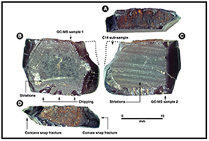
The tree resin artefact provides evidence for complex plant processing during early human dispersal (Figure 5A–D). The artefact is rectilinear, totally unlike globular, naturally formed resins, indicating that it was collected by humans directly from the tree. Scanning electron microscope (SEM) analysis suggests it was produced in a multi-step sequence. The resin is 13.5mm wide and 5mm thick, with planilateral dorsal, ventral and lateral surfaces, which suggests it pooled in a small rectilinear channel, possibly cut into the trunk of the tree itself. Curved parallel striations are present on the ventral surface and SEM analysis of the surface microtopography shows internal micro-striations reflective not of ripple marks but scraping on the resin itself. Minor scraping marks are also present on the dorsal surface, along with chipping along the edge, which occurred after hardening, perhaps when extracting the resin from the channel in the tree. Ethnographic observation on Waigeo indicates that people cut the bark of trees and allow the resin to accumulate before they return to extract the hardened resin one or more days later (see OSM). Concave and convex snap fractures at each end imply that, following removal from the channel, the resin was manually snapped into a 19mm long piece (similar to snaps on stone tools such as truncated burins (Hilbert et al. Reference Hilbert2018)) or broken after discard owing to footfall in the cave (as seen on silicious stone artefacts (Hiscock Reference Hiscock1985)).

Figure 5. Tree resin artefact (WAI-1-1024) from trench 2, directly dated to >55 000–49 620 cal BP: A) lateral side with rough surface texture; B) dorsal side with flat surface, chipping and minor scraping marks; C) ventral side showing parallel marks, possibly from scraping or the imprint of a scraped surface; D) lateral side with rough surface texture showing snaps. E illustrates a provisional hypothesis for the sequence of resin artefact production (figure by authors).
Gas chromatography/mass spectrometry (GC/MS) and pyrolysis gas chromatography/mass spectrometry (Py-GC/MS) identify the artefact as a triterpenoid resin from a flowering tree or shrub (Angiosperm), ruling out a conifer source such as Agathis labillardierei, known to have been used in the more recent past on Waigeo (Figures 6 & S4). A triterpenoid resin also used on Waigeo, Vatica rassak or a similar species from the Dipterocarpaceae family, shares chemical similarities but is not a direct match for the Mololo artefact (Figure 6, Table S17, see also OSM). Although there are numerous ethnographic uses of resins in Island Southeast Asia (Bradshaw et al. Reference Bradshaw, Stern, Thompson, Barker and Farr2013), the Mololo artefact does not preserve evidence for its intended function.

Figure 6. Mass spectra of Mololo archaeological resin compared with reference specimens. A–E are total ion chromatograms based on GC/MS: A) Mololo archaeological resin (WAI-1-1024); B) ethnographic ‘damar merah’ from Waigeo (Ref_D2); C) Vatica rassak (Ref_R3_K57); D) ethnographic ‘damar putih’ from Waigeo (Ref_D3); E) Agathis labillardierei (Ref_R1_K08). F–I are pyrograms based on Py-GC/MS: F) Mololo archaeological resin (WAI-1-1024 GCMS1); G) Mololo archaeological resin (WAI-1-1024 GCMS2); H) Canarium salomonense (Ref_R4_K21); I) Prumnopitys ladei (Ref_R5_S19) (figure by authors).
No lithic pieces from Late Pleistocene contexts are unequivocally manually produced or used, but one siliceous limestone object from trench 2, layer 7 may be a core (Figure 7, Table S18, see also OSM). One anthropic limestone flake and two possible flakes are present in trench 2, layer 6, but their dating is imprecise. Moreover, there is no evidence for resin being used to haft any of the stones in the cave. Even in the Late Holocene layers, where cultural material was abundant, only six small radiolarian chert and five limestone artefacts were recovered. The sparseness of stone artefacts is characteristic of north-eastern Wallacea and north-west New Guinea, where many tools were likely made from organic rather than lithic materials (Bellwood et al. Reference Bellwood, Irwin, Tanudirjo and Bellwood2019b); alternatively, lithics may have been discarded offsite or in another part of the cave.

Figure 7. Selection of Mololo lithic artefacts and possible artefacts. A) WAI-1-183 (trench 2, layer 3)—flake with impact point indicated by converging hackles (marked by arrows), clear platform, ventral face with bulb, and dorsal face with a rougher texture. Edges are post-depositionally altered preventing the detection of possible use-wear; B) WAI-1-2162 (trench 1, layer 3) – flake with platform, partly cortical dorsal face and one removal. No distal end or trace of utilisation; C) WAI-1-701-B-ii (trench 2, layer 6)—smooth ventral face (iv) and platform, and dorsal face with smooth surface within two previous removals compared with rougher dorsal face (i). The edge of fracture on ventral face (pink) presents rounding and micro-polish (ii) likely resulting from scraping motion. The sharp edge (blue) does not show utilisation (iii); D) WAI-1-701-B-i (trench 2, layer 6)—flake with cortical convex face and fresher flatter face possibly indicating knapping, potential platform, and long irregular sharp edge with no clear evidence of utilisation; E) WAI-1-700 (trench 2, layer 6)—possible small flake with platform, smooth face with small bulb, and long possible flake removal on opposite side. Micro-scars on distal part of right ventral edge, possibly use-related or taphonomic; F) WAI-1-1005-C (trench 2, layer 7)—fragment with two possible concave flake removals, no evidence of use-wear (figure by authors).
Pleistocene environments and subsistence
The Pleistocene fauna from trench 1 reflect natural deposition and are characteristic of cave sequences in the tropics; small insectivorous bats (including Hipposideros maggietaylorae and Miniopterus sp.), medium-sized fruit bats (Dobsonia sp.), frogs (Anura) and rodents (Muridae) (Table S19 & OSM). The remains of insectivorous bats include Hipposideros, a taxon that forages in closed-canopy forests, but Miniopterus, a genus that forages on forest edges, is also present, indicating some clearings around Mololo. Post-depositional alteration such as polish, brown discolouration and minor pitting on these bones suggest dead animals were incorporated with acidic guano, with some perhaps accumulated by avian or marsupial predators.
The Late Pleistocene fauna from trench 2, closely associated with or underlying the resin artefact of layer 7, includes forest species, some likely hunted by humans. Most specimens are pteropodids (number of identified specimens (NISP) = 35), probably all deriving from New Guinea bare-backed fruit bats (Dobsonia magna), a species commonly hunted around northern Sahul (see Hawkins et al. Reference Hawkins, O'Connor and Kealy2016; Tables S20 & S21, OSM); only a single insectivorous bat bone was identified. Of the four Dobsonia magna teeth identified from layers 7 and 8, none display tooth wear, indicating the animals were young adults at death and unlikely to have died naturally. Other specimens suggestive of human predation include those from a ground-dwelling bird (Phasianidae) and mid-sized marsupials, while the New Guinea spiny rat (Rattus praetor) could have been deposited by human or non-human predators. Attempted species identification of non-diagnostic bones from the Pleistocene deposits based on mass spectrometry failed owing to a lack of collagen. Bleached colouration and a lack of pitting on most specimens indicate the animals were deposited onto clays exposed to light rather than into guano. Although no cutmarks are found on the Late Pleistocene fauna, neither is there evidence of consumption by non-human predators (large fruit bats and medium-sized terrestrial birds and marsupials are not known to be common targets of raptors around New Guinea).
One sea urchin (Echinodermata) spine was recovered from trench 1, layer 10, suggestive of manual importation from the coast by humans before 43ka (Figure 8). Another spine with asymmetrical abrasion along one side was found in trench 2, layer 6, dating to between >55 and 7.5ka (Figure 8). It is possible that this has been worked by humans, but recrystallisation has removed the original surface features. A tooth from a fast-swimming, carnivorous fish (Scombroidei sp. possibly Sphyraena cf. barracuda or Gymnosarda unicolor) was also found in trench 2, layer 6. The black polished surface of the fish tooth closely matches discolouration of terrestrial long bones from trench 2, layers 7 and 8, and suggests it dates to the Late Pleistocene. Unfortunately, diagenesis means these specimens are not suitable for radiocarbon dating.

Figure 8. Aquatic resources at Mololo. A) Hyridella cf. misoolensis (WAI-1-1022) from Mololo Cave, trench 2, layer 5. Note delamination and recrystallisation of aragonite shown in inset SEM micrograph. B) Sea urchin specimens from Mololo Cave: WAI-1-2086-A-xiii, small Echinoderm spine from trench 1, layer 5; WAI-1-1169-E, large Echinoderm spine from trench 1, layer 10; WAI-1-1551-A-ii, large Echinoderm spine with abrasion from trench 1, layer 5A. C) Sea urchin spine (WAI-1-696-B) with an edge alteration from Mololo Cave, trench 2, layer 6. D) Scombroidei sp. teeth from Mololo Cave: WAI-1-773-B, subfossilised tooth from trench 2, layer 6; WAI-1-2058, tooth from trench 1, layer 5A. Both specimens preserve diagnostic lateral margins and concave shape at the apical end (figure by authors).
One hand-collected fragment of charred monocotyledonous stem tissue from trench 1, layer 6, likely deriving from an underground storage organ, was directly dated to 13–12.8ka (Figure 9, Table S22, OSM). Owing to fine grain physical erosion, no pollen or phytoliths were identified in Late Pleistocene sediments, but contexts older than 8.2ka preserve fern phytoliths. In contrast, those from Late Holocene contexts contain pine pollen, fern, grass, palm and possible breadfruit phytoliths, and sponge spicules (Figure 9, Table S23, OSM), the latter incorporated into the site at the same time as marine shell.

Figure 9. Archaeobotanical remains from Mololo. A–D are SEM images of charred monocotyledonous stem tissue from trench 1, layer 5–6 (WAI-1-1161) and layer 6 (WAI-1-1236), vb = vascular bundle. A & B) longitudinal section of WAI-1-1161, with a vascular bundle exposed longitudinally within a parenchyma matrix, B shows a close-up of the vascular bundle; C & D) transverse section of WAI-1-1236, with several vitrified vascular bundles, within a parenchyma matrix, D shows a close up of vitrified vascular bundles. E–J are biogenic silica recovered from Mololo Cave sediment samples: E) sponge spicule from trench 1, layer 2 (WAI-1-1612-C); F) sponge spicule from trench 1, context 011 (WAI-1-1379-B); G) sponge asterone microsclere from trench 1, layer 3 (WAI-1-1422-B); H) sponge spicule from trench 1, layer 3 (WAI-1-1422-B); I) fern spore from trench 2, context 098 (WAI-1-424-B); J) an elongate entire and a blocky phytolith, likely from grasses, from trench 2, layer 2 (WAI-1-606-B) (figure by authors).
The wide variability in carbon stable isotope (δ13C) values of D. magna enamel during the Late Pleistocene indicates their selection of diverse forest patches for foraging, with open forests, woodlands and closed-canopy forests all available (Figure S5, Table S24, OSM). Isotope data indicate the expansion of dense rainforests after the Last Glacial Maximum, c. 14–11ka (Figure 10). Enamel δ13C values for rodents (Muridae) provide a more localised signal of Late Pleistocene forest cover and indicate there were closed-canopy forests near Mololo (Figure S5, Table S24, OSM). Patchy Late Pleistocene forest mosaics were probably produced by minimally compressed temperatures, but clearances by humans would have further encouraged forest gaps.

Figure 10. Reconstruction of Mayalibit Valley ecology from the Late Pleistocene to the Late Holocene alongside fruitbat and rodent δ13C and δ18O isotope results. The Late Pleistocene was characterised by patches of open and closed tropical forest, followed by expansion of closed canopy forests in the Terminal Pleistocene. The infilling of Mayalibit Bay in the Early Holocene created open areas near Mololo, possibly further encouraged by clearances. Diversification of forest patches in the Late Holocene may be caused by burning (figure by authors).
Discussion
The Mololo investigations provide critical, albeit sparse, evidence for occupation along the northern equatorial route to Sahul before 50ka (possibly >55ka). H. sapiens probably produced this archaeological record, moving by raft/boat through the humid tropics. However, it should be noted that based on modern population genetic evidence (Jacobs et al. Reference Jacobs2019) it is not currently possible to exclude the possibility that Denisovans or people who carried both H. sapiens and Denisovan ancestry—having admixed in the islands of Wallacea or continental Eurasia—migrated along this route.
Based on our evidence, the northern route to what is today New Guinea through Waitanta is a viable corridor for the early colonisation of Sahul. Primarily owing to chronometric imprecision at Raja Ampat, Timorese and Australian sites, the timing of people's movements through the northern route, and how those relate to dispersals along the southern route, needs clarification. At Madjedbebe in northern Australia, the minimum estimate for initial occupation is 59.3ka, although it may begin several millennia earlier (Clarkson et al. Reference Clarkson2017). Occupation of other Australian sites probably post-dates 50ka but may begin as early as 52ka (Norman et al. Reference Norman2022). Similarly, the earliest known sites from the mainland of New Guinea, in the Ivane Valley and Huon Peninsula, and on offshore islands such as New Ireland and New Britain, all post-date 50ka and most post-date 45ka (Summerhayes et al. Reference Summerhayes, Field, Shaw and Gaffney2017). It is likely that Waitanta was first frequented by those living further west in Wallacea, but it remains possible that humans initially entered Sahul via Australia and rapidly moved north-west, arriving at Waitanta from what is today the Bird's Head Peninsula of New Guinea. The dynamics of these movements therefore need explication, especially how humans dispersed along these different chains, whether either of these island groups hosted ‘back-migrations’ from Sahul after initial colonisation, and whether there might have been latitudinal movement between these chains. Ongoing excavations at Mololo, alongside luminescence and radiocarbon dating of the lowest deposits, aim to provide clarity about the earliest human occupation of the site.
The earliest humans on Waitanta adapted to insular tropical forests by using native vegetation and animals. The presence of multi-stage resin processing at Mololo supports evidence from Madjedbebe (Australia) and Niah (Borneo) that indicates H. sapiens were engaging with diverse and complex plant processing techniques (Barker et al. Reference Barker2007; Bradshaw et al. Reference Bradshaw, Stern, Thompson, Barker and Farr2013; Florin et al. Reference Florin2020). Although resins have been used since the late Middle Pleistocene (Mazza et al. Reference Mazza2006; Wadley et al. Reference Wadley, Hodgskiss and Grant2009), the Mololo resin is the earliest known use of tree exudates by our species outside of Africa. Alongside its possible use as a fuel source, resin could be used as an adhesive to haft stone and bamboo onto composite organic tools, and in the construction of boats (Allen & O'Connell Reference Allen and O'Connell2020). Watercraft were necessary to transport scores of people between Wallacea and Sahul, creating biologically viable founder populations of around 1000 individuals over several centuries, as indicated by demographic modelling (Bradshaw et al. Reference Bradshaw2019).
Despite Waitanta being faunally depauperate, hunters targeted small native animals such as terrestrial birds, marsupials and perhaps fruit bats in the rainforest and may have transported marine resources from the coast. This study therefore contributes to debate about H. sapiens dietary breadth (O'Connell & Allen Reference O'Connell and Allen2012; Florin Reference Florin2022), showing that humans along the northern route were not exclusively marine specialists as argued for those along the southern route 42ka (O'Connor et al. Reference O'Connor, Ono and Clarkson2011; Roberts et al. Reference Roberts2020), but moved between the coast and the interior to access the array of resources offered by island rainforests.
Conclusion
Multi-proxy archaeological and palaeoecological analyses of the Mololo Cave sequence on the palaeo-island of Waitanta provide evidence for the earliest known peopling of the Pacific region >55 000–50 000 years ago. These humans practised complex plant processing and engaged with both coastal and tropical forest ecologies. The Raja Ampat archaeological record provides some of the earliest global evidence for humans exploring rainforests outside Africa and the earliest evidence of our species using small islands. Capacities for adaptive flexibility and environmental transformation likely stimulated human movements into insular rainforests, previously beyond the range of other hominin species. These settings help us to understand the process of cultural and biological diversification generated as our species dispersed around the planet and began to push the boundaries of novel habitats, and how humans have become enmeshed in these ecologies for tens of millennia.
Acknowledgements
Warsambin and Lopintol communities permitted excavation at Mololo Cave and supported fieldwork, Herman Soor (Raja Ampat regency government) and Wolter Gaman (Intelektual Suka Maya) provided assistance during survey. Excavation assistants included Melkion Amberbaken, Olos, Nathanial, Otniel, Otto, Robert, Isak, Demianus, Demersis, Septinus, Peter, Yan, Fernandes and Paul. We thank Gilar, Lazuardi and Yaqin, research assistants in Yogkayarta, Antoine Lourdeau, Pierre Voinchet, Xavier Gallet, Camille Daujeard, Sylvie Beyries and Gilles Durenmath for advice and assistance in lithic analysis, M. Großkopf and M. Weber for U-series laboratory assistance, Cam Webb for botanical advice, Christoph Parsch for zoological advice and Laura Arnold for linguistic advice. We thank two anonymous reviewers for their supportive comments. Fieldwork was carried out under Indonesian research permit 359/SIP/FRP/E5/Dit.KI/X/2018.
Funding statement
Fieldwork: National Geographic Explorer Grant (HJ-058ER-17), Evans Fund Fellowship, University of Cambridge School of the Humanities and Social Sciences Research Grant, Magdalene College Anthropology and Archaeology Fund, Leakey Foundation Research Grant. Radiocarbon dating: Royal Anthropological Institute Horniman and Sutasoma Awards, the Evans Fund, NRCF (NERC) Radiocarbon Fund. Py-GC/MS analysis: Quaternary Research Association Award. Isotope analysis: Max Planck Society. U-series dating: Deutsche Forschungsgemeinschaft (INST 247/889-1 FUGG).
Supplementary material
To view supplementary material for this article, please visit https://doi.org/10.15184/aqy.2024.83.


 Open access