


Introduction
It took less than three centuries to reclaim the vast peat areas near Amsterdam. Reclamation started at the end of the 10th century and was completed by the end of the 13th century. Within these three centuries, the morphology of the peatlands changed considerably: peat domes and ridges, which reached around 4 m above sea level (the ‘Dutch mountains’ of the western Netherlands) completely disappeared, and catchment areas, watershed margins and river drainage all changed. It has long been considered that during the High Middle Ages the former bailiwick of Amstelland was drained by one river, which had given this whole area its name, Amstel, and some centuries later the city of Amsterdam. For palaeogeographers, there was no question about it: at least for the last two millennia the Amstel river and its branches flowed through Amstelland discharging into the Almere, the successor of Lake Flevo in Roman times and the predecessor of the former ‘Sudersee’ (the counterpart of the North Sea).
This paper demonstrates that around 800 AD Amstelland was drained by two rivers, which between the 11th and 13th centuries were connected by the excavation of a canal more than 2 km long (Text 1). It is evident that this idea will not only change our understanding of Mediaeval water management in the Amstelland area, but also of the Mediaeval agrarian reclamation history of the peatland, in which pre-urban Amsterdam has its origins.
Text 1: Historiography
In modern Amsterdam, the dug Amstel canal is the part of the Amstel river running from Omval to the Blauwbrug. The historiography on this idea starts with Groesbeek, who in 1966 cautiously questioned the idea of one river Amstel (Groesbeek, Reference Groesbeek1966). In 1973 the soil scientist Pons was the first researcher to propose the possibility of a partly excavated river course (Pons, Reference Pons1973). Since then, several authors have discussed this issue. In 2004 de Bont introduced a new historical geographic approach, which in 2008 was expounded as a major part of his dissertation (de Bont, Reference de Bont2008: 484–511). For an extended historiography on the matter, see de Bont (Reference de Bont2008: 475–482).
There is some dispute amongst authors regarding the timing of clay deposition alongside the Amstel river. According to some researchers, the earliest clay soils (clay on peat) date back to the Early Middle Ages (de Gans & Bunnik, Reference de Gans and Bunnik2011). However, the clay was deposited in a rather short period after the digging of the canal that connected the northern and southern Amstel, but before this newly created river course was dammed and non-agrarian settlement developed on both riverbanks; the name of this settlement, Amestelledamme (literally translated as dam in the river Amstel), later became Amsterdam.
To disentangle this Gordian knot it is necessary to discover when the Amstel canal was cut and when it was dammed. This requires an appraisal of the natural landscape in the Amstel region around 800 AD and the character of Mediaeval agrarian peat reclamation, which preceded the rise of Amestelledamme, a village occupied by fishermen and craftsmen.
In contrast to physical geographers and other geoscientists who study the landforms and sediments of the past, historical geographers often seem to lack hard evidence and sometimes historical sources are not available. This discipline was once compared with Emmental cheese; a historical geographer has to cope with the fact that there are many holes in our historical knowledge. The oldest more or less reliable maps available for the western Netherlands date from the 16th century and are closely connected to Mediaeval religious activities. These documentary sources are relatively sparse in coverage and even archaeological (artefactual) material lacks precision, for example the finds from Mediaeval settlement in this area all date between 1000 and 1300 AD, a timeframe of changing dynamics in these peatlands.
In this paper the reconstruction of the early Mediaeval landscape and the natural drainage structure in the Amstelland area is presented. A general picture of the reclamation and settlement history from the 9th until the mid-13th centuries is provided. The natural landscape dynamics are described as well as those created by peat reclamation activities, which itself affected the people who drained the landscape. The lack of many contemporary written sources is offset by the availability of very reliable and detailed mid-19th century topographic maps (the topographical archive). Working with this archive requires a critical analysis of the resource, especially how to recognise/distinguish younger, post-Mediaeval historical information (de Bont, Reference de Bont2008: 34–37, 237–272).
The natural landscape around 800 AD
Amstelland was part of an enormous peat area, which started to grow around 5500 BC and reached its optimum spatial extent around 800 AD (Vos et al., Reference Vos, Bazelmans, Weerts and van der Meulen2011: 42–69). During the Early Middle Ages the former proto-IJ basin, a prehistoric watercourse (Vos et al, Reference Vos, Bazelmans, Weerts and van der Meulen2011: 47, 51, 55; Lange et al., Reference Lange, Besselsen and van Londen2004), was partly impassable, filled with eutrophic and sometimes even mesotrophic peat (Fig. 1). The Great Holland Watershed formed the backbone of the vast Mediaeval peatlands in the province of North Holland, north and south of the proto-IJ basin. A secondary watershed was located southeast of the Late Mediaeval city centre of Amsterdam, running through the area now occupied by Lake Watergraafsmeer. Northern Amstelland was occupied by a river that is called here the northern Amstel, which drained into Lake Almere. The southern Amstelland was drained by its counterpart, the southern Amstel, which represents the most western arm of the river Vecht system; it also drained into Lake Almere. The upper course of the southern-Amstel rose on the western slope of this secondary watershed, where centuries later Lake Watergraafsmeer developed.

Fig. 1. The natural landscape of Amstelland around 800 AD. Oligotrophic peat ridges: dark purple; eutrophic peat plains: light purple; Pleistocene ice-pushed ridge: yellow; Great Holland Watershed: thick brown line; secondary watershed: thin brown line. Topography: Topographical and Military Map of the Netherlands, 1849–50, original scale 1:50.000.
On onomastic grounds, it was possible to reconstruct the old name of this upper branch of the southern Amstel as *tumapa, which means ‘running water’ (de Bont, Reference de Bont2008: 559) (‘words with an asterisk are postulated or hypothetical forms, that is they are words not recorded in independent use or only found in use at a later date’ (definition used by A.D. Mills, 1998, Oxford Dictionary of English Place Names (new edition), Oxford University Press, p. 401)).
This hydronym fits in with some others north of the IJ basin, for example Jisp and Stierop, in which the etymon apa can also be recognised, meaning ‘water’ (Krahe, Reference Krahe1964: 21–24; Künzel et al., Reference Künzel, Blok and Verhoef1988), in connection with a determinative ‘bubbling’, ‘gurgling’ or even ‘foaming’ (Schönfeld, Reference Schönfeld1955, s.v. Jisp, Stierop). In this historical geographic context the apa hydronym forms the opposite of the ee hydronym (IJ, Diem, Waterlandse Die) in its meaning of ‘hardly floating’ or even ‘stagnant water’ (de Bont & Kleij, Reference de Bont and Kleij2012: 17–18). Some of the old prehistoric hydronyms in the western part of the Netherlands seem to indicate the natural morphology and drainage system of the natural peatland (Fig. 1).
The western part of Amstelland was covered with oligotrophic peat ridges whilst the eastern part consisted of more eutrophic peat plains. East of the river Vecht (the northwestern branch of the Rhine system), another oligotrophic peat ridge egressed to the western slope of the Pleistocene ice-pushed ridges of the Gooi area (de Bont, Reference de Bont2008: 347–369, fig. 239).
The natural water system southeast of Amsterdam was part of the discharging system of the river Vecht. The drainage of the peatland on both sides of the upper course of the southern Amstel, being the most western blind arm of the Rhine-Vecht system discharging in a northern direction, was rather poor. Although there is not too much hard evidence for the existence of a secondary watershed between the northern Amstel and the southern Amstel around 800 AD, the presence of (at least) one mesotrophic peat layer is possible (de Bont, Reference de Bont2008: 479–480).
Agrarian peat reclamations
In the year 1113 AD, the Bishop of Bremen (Germany) invited some inhabitants of the peat areas along the mouth of the river Rhine into his diocese in order to drain and reclaim the peatlands along the river Weser and river Elbe (Koch, Reference Koch1970: nr. 98). These ‘Hollanders’ (as they were called in the Bishop's charter) took along with them a reclamation system in which a totally new technical and juridical approach was used (van der Linden, Reference van der Linden1956, Reference van der Linden1982; de Bont, Reference de Bont2008: 126–128; van der Ven, Reference van der Ven2004). They reclaimed the peat area by digging ditches to create parcels of land of 30 rods by 6 furlongs (around 115 m by 1250 m). We can assume that the combination of size and form were the optimum to create a sufficiently drained piece of peat to start an agrarian enterprise which gave an average farming family the opportunity to survive (de Bont, Reference de Bont2008: 119, 127, 156); the parcels were directionally aligned to secure an optimal drainage of the peat area. The ditches were dug hooked at the contour lines of the peat domes and ridges to secure a quick first drainage of those peat morphologies. For the first couple of centuries after reclamation the (length of the) ditches provided enough room for temporary water storage during periods of inclement weather.
Apart from Dutch reclamation activities in Germany, mentioned in the charter of 1113, there is no contemporary information about the technicalities of reclamation in relation to Mediaeval landscape morphology. Some years ago, three models were proposed to explain the procedure for the reclamation of a peat ridge (Fig. 2), a peat dome and a peat plain (de Bont, Reference de Bont1994, Reference de Bont2008: 199–230). The most important difference between the reclamation of a peat dome and peat ridge on the one hand from a peat plain on the other is the difference in drainage organisation. During the first centuries after the reclamation of peat domes and ridges, they had natural drainage. Even before human interference, the drainage of peat plains was rather bad and after reclamation it became worse. Even after reclaiming the undulating landscape of peat domes and peat ridges it took some centuries before the surface of the land sunk below sea level as a result of oxidation and other mass wasting processes. Needless to say this peat wastage did not help drainage much either and consequently the building of dikes became necessary. This event marks the end of the Mediaeval peat reclamation period, known in Dutch literature as the Great Reclamation (van der Linden, Reference van der Linden1956).

Fig. 2. The reclamation of a peat ridge (10th to 12th centuries).
Most of the peat reclamations on both sides of the northern and southern Amstel conform to the model of reclaiming peat ridges. Shortly before 1000 AD the peatland or peatland area was drained by the excavation of a regular pattern of ditches and made suitable for habitation and agriculture (a mixed farming economy). The first settlement phase was characterised by each farm sitting within its own reclamation parcel. However, because of the drainage (oxidation and subsidence) the ground surface level dropped and the environment became too wet for arable farming. New areas of peat therefore had to be reclaimed and arable land created with farming settlement following, creating secondary, linear settlements. The previously farmed (old) fields with their high ground-water levels were only suitable for cattle breeding. These changes associated with reclamation mean that by around 1500 AD arable farming was no longer possible in the western Netherlands. In the 15th century regular grain imports from the eastern Netherlands and France became common. From about 1475 grain imports from the Baltic took place on an irregular basis and after 1500 the Baltic became the main important production area of grain for the western Netherlands (van Tielhof, Reference van Tielhof1995). This trade was the cornerstone (in Dutch: moedernegothie) of the 16th and 17th century wealth on which the city of Amsterdam was built.
The agrarian peat reclamations along the borders of both the northern and southern Amstel started at the end of the 10th century. The Mediaeval city structure of Amsterdam has its origins in the Mediaeval division of land into agrarian parcels, a pattern that can be recognised in the layout of 17th and 19th century working-class neighbourhoods and in mid-19th century topographical maps (de Bont, Reference de Bont2008: 512–524). The drainage of the newly reclaimed area along the northern Amstel was directly towards the Almere, which from the 11th/12th centuries onwards was enlarged to the Sudersee, improving drainage even more. In contrast, the drainage of the area along the southern Amstel, being the most western, stagnating arm of the river Vecht system, was rather bad and provides the main underlying reason for digging the Amstel canal.
Towards the Amstel canal
The northern and southern Amstel ran between two peat ridges, separated from each other by a mesotrophic, unreclaimed peat area, which functioned as a kind of secondary watershed. A remarkable feature of the supposed canal part of the river Amstel is that it consists of two straight parts connected by an irregularly shaped kink. This appearance differs in shape considerably from other natural sinuous watercourses in the peatlands of the western Netherlands. Only the Mediaeval Delf canal, which gave the city of Delft its name, has a similar appearance, comprising several straight parts connected by kinks. The different parts of the Delf canal were dug and connected between the mid-11th and 12th centuries (de Bont, Reference de Bont2000: 39).
Several researchers have studied the historical and historic geographical background to the supposed Amstel canal. On some palaeogeographical maps, showing the early Mediaeval landscape of Amstelland, the river Amstel is shown issuing from its source more than 20 km south of the later city of Amsterdam, in a linear, northerly direction before discharging into the IJ basin. Other maps show two separate rivers, which were subsequently connected by a canal. The latter was based on an idea of the soil scientist Pons, who drew a map with these two Amstel branches; this map was influential in the thinking of Dutch historical geographers, but was long ignored by archaeologists and, even until quite recently, palaeogeographers (Pons & van Oosten, Reference Pons and van Oosten1974: 25, fig. 14). More recently, the Atlas van Nederland in het Holoceen included a map of the early Mediaeval landscape of the Netherlands, which shows a northern and southern Amstel (Vos et al., Reference Vos, Bazelmans, Weerts and van der Meulen2011: 67), although it is similar to the map of that period published some years earlier (Fig. 1) (de Bont, Reference de Bont2008: 353, fig. 239). The main reason for connecting the northern and southern Amstel via a canal lies in the character of the regional hydrology, which is of course an important aspect of the physical context of the process of reclamation.
The people who reclaimed the western slope of the peat ridge (the Great Holland watershed) along the southern Amstel had to dig a canal known as the Boerenwetering (Farmers’ canal), which discharged its waters through the northern Amstel directly into the Almere/Sudersee. The creation of this canal fits into the Mediaeval history of the drainage of large parts of the peatlands of Holland (van Tielhof & van Dam, Reference van Tielhof and van Dam2006: 36–51; Louman, Reference Louman1982: 115–164; de Bont, Reference de Bont2008: 205–206). Some decades after the reclamation activities started, the subsidence of the land required several canals (each over 40 km in length) to be constructed to improve drainage; the Delf canal mentioned earlier was the first one. The oldest mention of the Boerenwetering dates from 1383 (van der Laan, Reference van der Laan1993: nrs. 403–405), but it was started at least two or even three centuries earlier (Groesbeek, Reference Groesbeek1966: 64–66). In the beginning, the Boerenwetering crossed the still unreclaimed part of the watershed between the northern and southern Amstel (de Bont, Reference de Bont2000: 46–47), discharging into the sinuous upper course of the northern-Amstel (Fig. 3: 1). If there was already a ‘complete’ river Amstel in existence draining directly into Almere/Sudersee, there would have been no need for these farmers to excavate the Boerenwetering since they could have drained their lands into this river using the hundreds of reclamation ditches themselves.
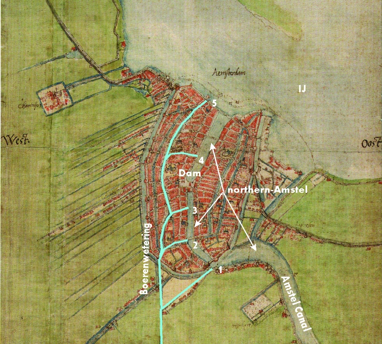
Fig. 3. Relocated discharging points of the Boerenwetering into the northern Amstel in the course of time. Topography: map of Jacob van Deventer, 1560.
Later on, the confluence point of the Boerenwetering and northern Amstel was relocated to the north, within the walls of the rising city of Amsterdam (Fig. 3: 2). Sometime later, the Amstel canal was created to connect the northern and southern Amstel, this newly created river had been dammed up. A younger mouth of the Boerenwetering (Fig. 3: 3) was now situated on the wrong side of this dam, which required its course to be lengthened by several hundred metres in order to create a new discharging point north of the newly built dam (Fig. 3: 4 and 5). Precisely how long the Amstel river could freely discharge into the IJ basin before it was dammed up is another question that has yet to be answered.
Digging the Amstel canal
There used to be no disagreement about the date of creation of the dam in the river Amstel. Historians all dated it to the second part of the 13th century, or more precisely between 1265 and 1275. In that year a settlement called Amestelledamme was mentioned for the first time (van der Laan, Reference van der Laan1993: nr. 1). According to some archaeologists, the dam dates from the first quarter of the 13th century (de Bont, Reference de Bont2008: 498–504).
The digging of the Amstel canal, which connected the northern and southern Amstel, was carried out in three phases (Fig. 4) (de Bont, Reference de Bont2008: fig. 357). The first digging phase (1) was started from a curve in the southern Amstel and followed a straight line towards the Old Church of Amsterdam, stopping at the supposed watershed. The Old Church was built on a mound along the eastern border of the northern Amstel, where a graveyard was originally situated. The oldest archaeological traces of that site date from the beginning of the 13th century, although some of the archaeological chronological interpretations are influenced by the opinions of historians rather than by the archaeological evidence itself, therefore earlier dating of this site is still possible. This proto-Amsterdam was not an agrarian settlement. Almost all the archaeological evidence envisages a linear settlement of craftsmen and fishermen, with small workshops on mounds, forming the first phase of an early embankment of the Amstel river (Sarfatij, Reference Sarfatij, de Melker and de Roever1995; de Bont, Reference de Bont2008: 512–530). The second digging phase of the canal was carried out from north to south (2), also stopping at the former watershed; the third phase (3) connected both canal parts by cutting through the former watershed (de Bont, Reference de Bont2008: 489–494).

Fig. 4. Digging the Amstel canal. Supposed watershed: yellow and brown; A-A’-B-B”: peat area that has been reclaimed after the Amstel canal has been dug. Underlying landscape reconstruction: 1000–1250 AD. Topography: Topographical and Military Map of the Netherlands, 1849–50, original scale 1:50.000.
After the northern and southern Amstel were connected, creating a new single river system, the uncultivated borders of the former Amstel canal (A-A’-B-B’’) were reclaimed. The entire reclamation was undertaken between the older reclamations along the former northern and southern Amstel. Most probably, the former supposed watershed (yellow and brown) was the last reclaimed peatland in the whole Bailiwick of Amstelland (de Bont, Reference de Bont2008: 530–532).
Dating the digging activities
Early reclamation activity (subsidence of the soil) and a series of devastating storm surges played a role in the formation of the Sudersee (Text 2). Although large areas of already cultivated peat land were drowned by these events, the natural drainage of the surviving peat lands improved radically.
Text 2: Storm surges
Gottschalk found mention in charters and chronicles of lands devastated by surges in the Sudersee area in the years 1170, 1196, 1214 (?), 1248, 1262 (?), 1286 (?), 1287, 1288, 1307, 1318, 1328 (?), 1334, 1343, 1344, 1357 (?), 1375, 1394, 1396, 1398, 1403 (?), 1404, 1409 and later (Gottschalk, Reference Gottschalk1971, Reference Gottschalk1975). van Mieris cites a charter which mentions Sudersee (‘Zuyder Zee’) on 9 March 1412–1413 (eastern style), but that seems rather late (van Mieris, Reference van Mieris1756: 228). According to Schönfeld, the hydronym Sudersee is mentioned for the first time around 1340 (Schönfeld, Reference Schönfeld1955: 36, 210). Paleogeography does not clearly reflect this onomastic phase of transition from Lake Almere to the Sudersee. The palaeogeographical maps of 100, 800 and 1500 AD show the enlargement from Lake Flevo, already mentioned by Tacitus and Ptolemy (Künzel et al., Reference Künzel, Blok and Verhoef1988, s.v. Flevum), to Lake Almere and Sudersee as an important, but not shocking, land-devastating process (Vos et al., Reference Vos, Bazelmans, Weerts and van der Meulen2011: 63, 67, 71). The supposedly important role of the All Saints surge of 1170 with a more sudden enlargement of Lake Almere into Sudersee is not reflected in these maps. There were most certainly land-devastating surges before the 1170 event in the area now referred to as Sudersee. Gottschalk, the specialist in this subject, reflects on several storm surges in that area mentioned in older literature and chronicles, but she has not been able to find any hard evidence in primary written sources and charters for the existence of storm surges before 516 AD (Gottschalk, Reference Gottschalk1971: 1–80).
Considering these landscape dynamics together with the urge of the people along the borders of the southern Amstel to improve the drainage of their newly reclaimed peatlands, a historian's suggestion that the Amstel canal was excavated in the 11th century is not surprising (van Reenen & Ibelings, Reference van Reenen and Ibelings2009: 91). Still, these historians do not use the improvement of the natural drainage as an important argument. They date the digging of the Amstel canal in connection with a special event in the history of the Counts of Holland. Count Dirk I (1061–1091) made a complete mess of his government. In 1063, the Bishop of Utrecht took power, supported by the emperor of the Holy Roman Empire. In 1076, the situation was normalised again (Blok, Reference Blok and Anrooij1999: 21; van Vliet, Reference van Vliet2002: 225–227) and the Amstel canal was supposed to have been dug during those few years. It has been suggested that only the bishop was capable of initiating such a great project. However, none of these digging activities is mentioned in the more than 125 relevant charters that have survived from the 11th century (Koch, Reference Koch1970: nrs. 65–91; Muller & Bouman, Reference Muller and Bouman1920: nrs. 150–259). This ‘reductio ad absurdum’ proves nothing and does not exclude digging activities in the 11th century.
The first mention of a dam in the river Amstel in 1275 seems to form an exact ante quem dating of the digging of the Amstel canal, but the sentence Homines manentes apud Amestelledamme (van der Laan, Reference van der Laan1993: nr. 1) is not univocal. If this sentence is translated as ‘people living near the dam in the river Amstel’ it is obvious that the Amstel canal was dug before 27 October 1275. If it is translated as ‘people living in a settlement named Amestelledamme’, and we consider this toponym as a fixed, onomastic meaningless label (for example, no one expects seven oaks in Sevenoaks, Kent) the dam in the river Amstel may be dated much earlier, giving the toponym Amestelledamme time to lose its original meaning and become a fixed toponym. How long this process took is hard to say. Logically the digging of the Amstel canal must date further back into history, but how far back is still unknown. In the middle of the 13th century many similar rivers were dammed, for example the Spaarne (Spaarndam), the Rotte (Rotterdam), the Zaan (Zaandam), the Ee (Edam) and the Schie (Schiedam).
Conclusions
In a rather short time span of no more than three centuries, the Amstelland area underwent enormous changes. Because of human interference the natural peat landscape disappeared completely. The natural drainage of the area was so bad that shortly after the first reclamations took place the settlers and their direct offspring had to rearrange and improve this drainage system completely, first by digging the Boerenwetering and later on by digging the Amstel canal. The Amstel canal was dug somewhere between 1063 and 1275, but it is perhaps more realistic to date its construction as ‘between the second part of the 11th century and halfway through the 13th century’. This period was long enough to explain the presence of marine clay sediments along the borders of the newly created river Amstel. Numerous storm surges from the north affecting the Sudersee and the IJ basin could have led to the deposition of such marine deposits. However, if we assume a shorter period in which the river Amstel was not dammed-up, this could also account for these clay sediments.


