Introduction
Most work concerning supraglacial debris melt-out, transport, and deposition (e.g., Reference SharpSharp, 1949; Reference BoultonBoulton, 1967, Reference Boulton1968; Reference EylesEyles, 1979) has examined forms and processes which occur over an ice substrate. This paper describes supraglacial debris re-sedimentation on to snow overlying glacier ice in a zone extending 200–300 m up-glacier from the margin of Sygjujökull, Iceland, and the unusual depositional features that result.
During July 1979, debris-charged supraglacial streams flowed from bare ice on to the marginal snow zone and percolated into the snow, producing linear deposits (referred to as re-sedimented debris trains) orientated orthogonal to the glacier terminus. The marginal snow zone is accumulated from wind-drifted snow during the previous winter, and is similar to the snow accumulation and wind-drift ice-wedge formation described at the edge of two ice masses by Reference HookeHooke (1970, Reference Hooke1973).
The term re-sedimentation (Reference LawsonLawson, 1979) is used because, while supraglacial sedimentation occurs at Sylgjujökull when material first melts out at the glacier surface, re-sedimentation takes place when debris is re-deposited on to the marginal snow zone after fluvial transportation down-glacier.
Sylgjujökull is a surging outlet glacier of the Vatnajökull ice cap, Iceland (lat. 64° 26′ N., long. 18° 03′ W.), which is at present (1979) in the quiescent phase between surges (Fig. 1). During surges, the last of which occurred in 1945, the glacier is heavily crevassed in the ablation zone (Reference ThorarinssonThorarinsson, 1964, Reference Thorarinsson1969), and it is only in the quiescent phase when the glacier is largely stagnant (Reference FreysteinssonFreysteinsson, 1969) that a network of supraglacial streams develops.

Fig. 1. (a) Location of Sylgjujökull within Iceland. (b) Location of Sylgjujökull at the western margin of Vatnajökull.
Origin of supraglacial debris
The main source of debris on the bare ice surface of Sylgjujökull between the marginal snow zone and the transient snow-line (c. 1.5 km above the glacier terminus in mid-July 1979) is a series of debris-rich ice layers (Reference Hambrey and MüllerHambrey and Müller, 1978). These dip up-glacier at 15° to 75°. They strike approximately parallel to the glacier front but also have fold axes parallel to the flow. Reference BoultonBoulton (1970) has described similar folds in Borebreen, Olav V Land, Svalbard.
Sediment melting out of the debris-rich layers is thought to be locally derived volcanic ash (Reference SteinthorssonSteinthörsson, [1978]) deposited on the surface of Vatnajökull and subsequently buried by snowfall. The ash is later exposed in the ablation zone as debris-rich layers within glacier ice. At Sylgjujökull, sediment released from the debris bands by ablation was black, with 85% of particles in the range 1–4ϕ. Similar grain size distributions and colour have been found for volcanic ash melting out of glacier ice by Reference Kozarski and SzupryczṅskiKozarski and Szupryczński (1973) at Sidujökull, and Reference Boulton and DentBoulton and Dent (1974) at Breiðamerkurjökull (Fig. 1a).
At the ice surface, larger particles were confined to the lateral margins of the glacier, and to a zone 250–400 m wide at the ice front. In the former situation, they are derived from the nunataks to the north and south of Sylgjujökull and, in the latter, their sub-rounded form suggests a basal origin (Reference BoultonBoulton, 1978). These coarse fragments were not involved in melt-water stream transport or re-sedimentation to form debris trains.
Debris transport in supraglacial melt-water streams
After release from the ablating ice, the ash is transported down-glacier in supraglacial melt-water streams. Suspended sediment concentration, supraglacial stream discharge, and suspended sediment load were measured in nine streams at points c. 500 m up-glacier (Fig. 2). Sediment concentrations were assessed using a depth-integrating sampler (Reference Gregory and WallingGregory and Walling, 1973, p. 153), and each 200 ml aliquot obtained was filtered and the sediment weighed later in the laboratory. Discharges were calculated from cross-sectional area and velocity measurements, while sediment load is the product of sediment concentration and discharge (Reference Leopold and MaddockLeopold and Maddock, 1953).

Fig. 2. Supraglacial melt-stream network and pattern of re-sedimented debris-train development. Bare ice gives way to snow down-glacier. Figure 1 locates the study area on Sylgjujökull. Note that horizontal and vertical scales are different.
Data were collected over 5 days of relatively constant weather (Table I). Suspended sediment concentrations and discharge were measured for the period (12.00–15.00 h) of maximum ablation and stream flow each day. Readings throughout the 5-day period were averaged for each stream.
Table I. Mean 12.00–15.00 h air temperature and cloud cover, 21–25 July 1971), at Sylgjujökull

Table II records the results and it should be noted that, although suspended sediment concentration and load values are accurate in relative terms, their absolute accuracy is less certain. However, mean peak suspended sediment concentrations in the nine streams varied between 61 and 430 mg l−1, and are of the same order of magnitude as Reference Nakawo [i.e. Nakao]Nakawo’s (1979) debris concentration of 87.8 mg l−1 in running water on the surface of G2 glacier, Nepal.
Table II. Mean peak (12.00–15.00 h) suspended sediment concentration, meltwater discharge, and suspended sediment load measurements for nine supraclacial streams, 21–25 July 1979 (sampling points are located in Figure 2)

The map of the supraglacial drainage network on part of Sylgjujökull (Fig. 2) shows that streams 4, 5, and 6 do not reach the marginal snow zone down-glacier, but instead descend a moulin 270 m from the glacier margin. The mean peak suspended sediment concentration of streams (measured 500 m from the glacier terminus) that actually reach the marginal snow zone varies between 61 and 190 mg l−1; their discharges range from 0.003 to 0.107 m3 s−1, and their loads between 0.2 and 20.3 g s−1. Measurements 200–300 m from the marginal snow zone are thought to reflect sediment transport to the debris trains because little stored sediment was observed in stream channels between the sample points and the snow zone during high day-time discharge.
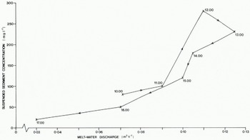
The behavior of stream 7 was examined in some detail. The suspended sediment concentration and discharge varies diurnally (Fig. 3), implying that sediment delivery to the marginal snow zone exhibits a daily rhythm. Lack of data for any stream over a 24-h period precludes examination of the total daily sediment delivery to the snow zone. A diurnal hysteretic loop in the relationship between suspended sediment concentration and discharge is also present (Fig. 4). The clockwise hysteretic loop shows that greater sediment concentrations occur on the rising limb of the diurnal hydrograph than at equivalent discharges during the falling stage. This may indicate a diurnal flushing out of debris stored in the channel during low night-time discharge. However, a greater amount of data concerning suspended sediment concentrations must be obtained before generalizations relating to diurnal hysteretic effects may be made for supraglacial streams.

Fig. 3. Suspended sediment concentration and melt-water discharge from stream 7 (Fig. 2) on 21 July 1979 between 10.00 and 17.00 h.

Re-sedimented debris trains
A series of re-sedimented debris trains (Fig. 5) was observed in the marginal snow-covered zone at Sylgjujökull (Fig. 2). They are composed of a 1–3 cm veneer of debris overlying snow. After initial deposition, differential ablation raises the debris trains relative to the general snow surface. 78% of the sediment within the debris trains was between 1 and 4ϕ, compared with 85% of material within the same size range in debris-rich layers up-glacier. This particle-size evidence, combined with that concerning suspended sediment concentrations and load in supraglacial streams, suggests that the debris comprising re-sedimented debris trains comes from the debris-rich layers cropping out in the ice higher on the glacier.

Fig. 5. A re-sedimented debris train orientated orthogonal to the glacier margin. Sylgjujökull. Note that the feature has developed on snow overlying glacier ice.
Melt-water streams transporting suspended sediment flow from a relatively impermeable ice substrate on to much more permeable snow at between 200 and 300 m from the ice margin (Fig. 2). On snow, the streams lose surface discharge as water percolates into the snow, and the suspended sediment is deposited on to the snow surface. The differential permeability of snow and ice is the key factor leading to debris re-sedimentation.
Daily amounts of re-sedimented debris-train extension and 14.00 h air temperatures were recorded at two sites (Fig. 2) during a 4-day study period (14–17 July). Only one day showed little debris-train extension ( < 1.0 m), and this coincided with the lowest 14.00 h air temperature (2.8 °C). On other days, debris-train extension ranged from 11.5 to 36.5 m, in association with 14.00 h air temperatures of between 3.9 and 6.4 °C. The highest amount of daily extension coincided with the highest 14.00 h air temperature. Reference Meier and TangbornMeier and Tangborn (1961) and Reference Gudmundsson and SigbjarnarsonGudmundsson and Sigbjarnarson (1972) both considered air temperatures an important factor influencing glacier run-off.
While re-sedimented debris-train initiation is dependent on differences in permeability between ice and snow, continued debris-train extension requires the further permeability contrast between snow and the sand-size material of the re-sedimented debris trains. Figure 6 illustrates this; water flows over re-sedimented debris, where permeability is less than on the surrounding snow. Debris-train extension is therefore suggested to involve a positive feed-back loop, wherein debris re-sedimentation reduces permeability in the snow zone, allowing further extension to occur. Debris-train extension may continue until the glacier margin is reached (Fig. 2).

Fig. 6. Water flowing in unchannelled form on top of re-sedimented debris overlying snow. The permeability is less on the debris cover than on the snow, allowing debris-train extension.
Several melt-water channels were observed in the snow zone, associated with re-sedimented debris trains (Fig. 7). Within the pools or basins in the channel reach, a layer of sediment is seen. Over the riffles or bars a film of refrozen ice conceals sediment. However, its presence was confirmed by probing. It is thought that refrozen melt water and sediment in combination allow channel flow to continue on the otherwise relatively permeable snow substrate.

Fig. 7. Melt-water channel in the snow zone low on Sylgjuökull, showing exposed sediment layers in pools and refrozen ice over bars. The photograph was taken at 19.00 h when little water was present.
Implications for pro-glacial deposition
As Sylgjujökull retreats between surges, re-sedimented supraglacial debris is deposited on to the till surface at the glacier marign. However, there are at least three reasons why this sediment is likely to be of little significance to the final glacial stratigraphy of the pro-glacial area. First, re-sedimented debris trains at Sylgjujökull are only 1–3 cm thick, and are discrete linear forms covering less than 10% of the marginal snow-zone surface. Secondly, a number of pro-glacial streams run parallel to the ice front and directly adjacent to it, therefore removing much of the re-sedimented debris. Thirdly, if Reference ClappertonClapperton’s (1975) suggestion that much pro-glacial sediment is entrained during the surging of Icelandic glaciers is correct, the fines deposited in the quiescent period between surges would be re-worked during the surging phase of the cycle.
Reference Boulton and DentBoulton and Dent (1974), working at Breiðamerkurjökull (Fig. 1). also found that supraglacial debris derived from volcanic ash and deposited on to the pro-glacial till made no significant contribution to total pro-glacial sedimentation.
Implications for dirt-cone development
At Sylgjujökull immediately up-glacier of the marginal snow zone, linear dirt-cone assemblages trending orthogonal to the glacier margin were noted. It is suggested that, as the snow-ice boundary at the up-glacier edge of the snow zone retreats down-glacier during the summer (analogous to the up-glacier retreat of the transient snow-line), linear debris trains are let down on to bare ice. This leads to the formation of linear swarms of dirt cones as a result of differential ablation, and provides an alternative explanation of the linear arrangement of dirt cones to that involving direct deposition on the beds of melt-water channels (e.g. Reference LewisLewis, 1940; Reference SwithinbankSwithinbank, 1950; Reference KnightonKnighton, 1973).
However, three points must be noted. First, no systematic observations were made at Sylgjujökull of this transition from debris trains to dirt cones. Secondly, the hypothesis cannot explain all the dirt cones on Sylgjujökull but only the linear assemblages immediately up-glacier of the marginal snow zone. Finally, the hypothesis does not affect the proposition that some dirt cones may also develop as a result of debris deposition on stream beds.
Conclusions
Re-sedimented debris trains form only when:
-
(i) There is a snow zone on the margin of the glacier snout.
-
(ii) The snout is relatively free of crevasses and moulins, allowing a supraglacial drainage network to develop.
-
(iii) There is a debris source of sand-size or finer material, which may be transported in melt streams.
At Sylgjujökull, these conditions are fulfilled because:
-
(i) Wind-drifting of snow builds up a marginal snow zone. However, it is not known whether such a zone is formed every year or less regularly.
-
(ii) The glacier is stagnant and in the quiescent period between surges. It, therefore, has few fissures relative to its surface while surging.
-
(iii) Volcanic debris becomes supraglacial in the ablation area to provide a source of fine sediment.
All three of the above conditions will not often be met. It is because of this that the linear depositional forms observed at Sylgjujökull, termed re-sedimented debris trains, have not been reported before.
Acknowledgements
The author wishes to thank Drs J. Andrews, N. Caine, and M. Hambrey for their comments on early drafts of this paper, and M. Sharp for both discussion and aid in planning the 1979 Cambridge Sylgjujökull Expedition. Financial assistance from Jesus College, Cambridge, and the David Richards Fund, University of Cambridge, is gratefully acknowledged. The members of the Cambridge Sylgjujökull Expedition, 1979, rendered considerable aid in the field. The National Research Council of Iceland kindly granted permission for this project to be carried out.