Introduction
A distinct class of seismic activity has long been associated with the seismic monitoring of three glaciated Quaternary Cascade Range volcanoes in Washington State. First identified on helicorder records from a station established on the southern flank of Mount Rainier in 1963, this class of events was characterized by a low-frequency coda (dominant frequency 1–2 Hz) and emersive onsets. The low-frequency events recorded on Mount Rainier were remarkably similar to seismic events recorded on active volcanoes in Japan, leading Reference Unger and DeckerUnger and Decker (1970) to suggest that the Mount Rainier low-frequency events were related to volcanic processes. Seismographs were installed near two other glaciated Cascade volcanoes in 1972, Mount St. Helens, 80 km south of Mount Rainier, and at Mount Baker, 220 km north of Mount Rainier. Low-frequency events were seen on these stations as well.
The Geophysics Program at the University of Washington began a series of three experiments during the summer of 1972 to investigate the source of the low-frequency events. That year, a seven-station temporary seismic network was operated around Mount Rainier. Results from this study confirmed that the source area for the low-frequency events was high on the volcanic cone. During the summers of 1973 and 1974 temporary seismic arrays were operated on Mount St. Helens. The first experiment indicated that the source of the low-frequency activity was related to glacier motions, and the 1974 experiment was specifically designed to study seismic properties on a kilometer-square area on the Nelson–Forsyth Glaciers system.
The major seismological result of this work was the determination that the glaciers, not volcanic processes, were responsible for the generation of the low-frequency events (Reference Weaver and MaloneWeaver and Malone, 1976; Weaver, unpublished). Later studies on Mount Baker begun in 1975 reached the same conclusion; low-frequency events recorded on a semi-permanent seismic network installed on Mount Baker in response to increased thermal emission, were caused by glacial, not volcanic, processes (Reference Malone and FrankMalone and Frank, 1975). The similarity between the Cascade low-frequency events and the volcanic earthquakes detected in Japan was determined to be a propagation effect, rather than a source effect (Reference Weaver and MaloneWeaver and Malone, 1976).
Glacier-associated seismic noises have been observed by other investigators. Reference VanWormer and BergVanWormer and Berg (1973) observed low-frequency events over large distances in Alaska where epicenters were in large ice fields and whose depths were essentially at the surface. Rogers (personal communication, 1976) reported locating unusual-looking seismic events in glacier-filled valleys in British Columbia. In these cases, the energies involved are many times larger than those of the seismic events reported by Reference Neave and SavageNeave and Savage (1970) on Athabasca Glacier which were due to crevasse openings.
In this paper we examine further the hypothesis of the glaciers as sources for the low-frequency events, reviewing the seismic data that constrain the nature of the sources. The problem of locating the events, demonstrating that the events occurred only in the glaciated areas on Mount St. Helens and Mount Baker, has been discussed elsewhere (Reference Malone and FrankMalone and Frank, 1975; Reference Weaver and MaloneWeaver and Malone, 1976). We suggest a discrete slip mechanism for the generation of the glacier events. Finally, we discuss the intriguing possibility of using seismic monitoring techniques to predict catastrophic ice movements.
Field experiments
The first two experiments (Mount Rainier and 1973 Mount St. Helens study) in this series recognized that the extensive glacial systems present on the mountains might be substantial sources of seismic noise, but the experiments were not specifically designed for the study of glacier properties. In this section we outline those sections of the Cascade experiments relevant to seismic properties of glaciers.
Instrumentation
All of the seismic experiments utilized instrument systems with three basic components— remote seismographic stations, a central data-recording site and a laboratory play-back/ analysis system. The remote seismic stations consist of a seismometer (usually operating in the vertical mode with a free period of 1 Hz), an amplifier-VCO unit with a range of amplifier gain settings, a radio transmitter, and a power source. With the exception of the 1974 experiment on Mount St. Helens, all of the seismometers were deployed in rock adjacent to glaciers rather than in the ice. Signals from the remote sites are received at a central recording site, sometimes at distances well removed from the study area. The seismic data were recorded on magnetic tape along with timing information. One data channel was recorded on a helicorder record, providing a continuous paper play-out that facilitates event retrieval in the laboratory. Using the helicorder trace to determine event times, selected events can be played back in the laboratory with a tape recorder and an eight-channel strip-chart recorder. Play-back speeds usually allowed for timing precision of ±0.01 s for events with sharp impulsive first arrivals and good signal-to-noise ratios. Alternatively, the magnetic tapes can be digitized and processed on a mini-computer. Overall, the seismic system has a nominal gain of several hundred thousand peaked at 15 Hz.
Mount Rainier
Mount Rainier is the highest (4392 m) of the Quaternary volcanoes in the Cascade Range and its slopes support the largest glacial system (100 km2) in the United States outside of Alaska. The permanent station on the southern side of the mountain is 12 km from the summit and 6 km from the terminus of Nisqually Glacier.
A network of portable seismic stations was operated on and around Mount Rainier in the summer of 1972 to record seismic activity related to the volcano. We suspected glacier movements to be producing seismic noise here but could not confirm this until a much more detailed study was done. On Mount Rainier, we did attempt to observe ice movement which might correlate with seismic activity. Only the very largest surface ice avalanches produced a small response at stations a few hundred meters away. Most of the seismic events occurred without any visible or audible ice motion.
Mount St. Helens
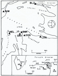
Mount St. Helens (2950 m) is a very young Quaternary volcano in south-western Washington and major glaciation is confined to the northern half of the cone (Fig. 1). The cone is steep with slopes averaging 28°. The glaciers are relatively thin, on the order of 30–50 m thick. The first St. Helens experiment in 1973 and the seismological aspects of the 1974 experiment, related to the event-location problem, have already been described (Reference Weaver and MaloneWeaver and Malone, 1976). Following the results of the 1973 experiment, which indicated the glaciers were the source for the low-frequency events, a relatively accessible section of Nelson Glacier–upper Forsyth Glacier was chosen for detailed study in the summer of 1974. Two independent seismic arrays were deployed. The first, using the general system outlined above, established stations with a 1 km spacing and recorded continuously (Fig. 2). Near the center of one side of this larger array, two stations, CRV and DOG, were operated 67 m apart. Station CRV was dug into a crevasse in Nelson Glacier, while DOG was deployed in the volcanic rocks on the “Dogshead” (Fig. 2), providing an opportunity to compare seismic signals recorded on rock with those recorded on ice. Near these two stations, a second array was installed across Nelson Glacier (Fig, 2, inset). This array, labeled SIE in Figure 2, was initially used in a standard refraction configuration, to record a series of small explosions. Four geophones (A-2, 4, 9, and 11 in Figure 2) were then re-deployed to form a two-dimensional array to facilitate locating locally generated glacial activity. The SIE array recorded for a few seconds during each of the shots and for an hour in the two-dimensional mode.

Fig. 1. View of Mount St. Helens from the north-east. Forsyth Glacier is the large crevassed glacier on the right side of the photograph and Nelson Glacier is in the center.

Fig. 2. Plan view of the 1974 Mount St. Helens experiment. Solid triangles are continuously recording array stations; station DGH was re-located to DOG. The inset shows the SIE array geophones; crosses mark the location of shot points.
Glacier event charcteristics
Historically, the glacier events were first distinguished from tectonic earthquakes by their low-frequency coda. As studies progressed, seismic stations virtually surrounded by active glaciers on both Mount St. Helens and Mount Baker showed that the low-frequency character attributed to this class of events was a function of the epicentral distance between source and receiver. The near-field records from both mountains showed substantial high frequency in the event codas and correspondingly more impulsive arrivals (Fig. 3). For the example shown (Fig. 3), station CRV is 300 m from the epicenter, NEL 350 m and DOG 425 m. Distinct arrivals are seen at all three stations. More distant stations show substantially lower frequencies typical of stations either removed from glaciers or removed from the source area (SUM is near active glaciers but well removed from the source for this event). The monochromatic coda seen at CRV, a station located on ice (Fig. 2), is likely the result of a trapped glacier wave discussed below.

Fig. 3. Glacier event from the 1974 array (refer to Figure 2 for station locations). Arrows show time and direction of the first arrival.
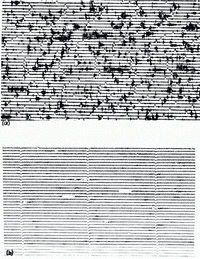
In addition to the existence of near-field high frequencies, all seismic stations near glaciers detected an exceedingly large number of events. A section of a helicorder record from 13 August 1973 from a station located on a rock ridge between two glaciers is compared in Figure 4 with a helicorder record from a station well removed from the Mount St. Helensglaciers. The glacier record shows a tremendous amount of seismic activity, with discrete events occurring nearly every minute. Many times fewer events are seen on the non-glacier station record. Similarly, the first arrival for a given event is always at a glacier station, and with very few exceptions always first at the higher stations, i.e. no events had a first arrival at station LDG (Fig. 2) during the brief 1974 study. This observation was also true for events studied in detail on Mount Rainier—of the three stations near Nisqually Glacier, the first arrival was always at the highest station.

Fig. 4.
-
(a) Helicorder record from a station surrounded by active glaciers for 13 August 1973. Time pulses are at 1 min intervals.
-
(b) Helicorder record from a non-glacier station for the same time period as in (a). Time marks at 2 min.
Event counts
The best data base for examining the long-term behavior of the glacier events is from Mount Rainier, where the record is available from 1963. The permanent station is recorded on a helicorder and all of the electronics are housed in a building, insuring good station reliability. Event counts for the period from October 1963 through December 1974 are shown in Figure 5. During this interval, with the exception of the bracketed months (March 1973 through June 1974), only two observers read the records, and events were not counted unless they met chosen amplitude criteria (personal communication from L. A. Rasmussen, 1974). Through June 1971, local tectonic earthquakes have been included in the counts, but this does not seriously bias the data set since these do not amount to more than a few per month at most. The striking feature of these data is the three-fold increase in activity that occurred in 1969. This large peak coincides with the observed surface break-up of Emmons Glacier on the north-east slope of Mount Rainier. An annual cycle is also apparent. A broad peak in activity is seen between April and September, followed by an annual low between December and February. A similar annual cycle has also been seen at Mount St. Helens, but the data set is not nearly as complete or carefully read as the Mount Rainier data.
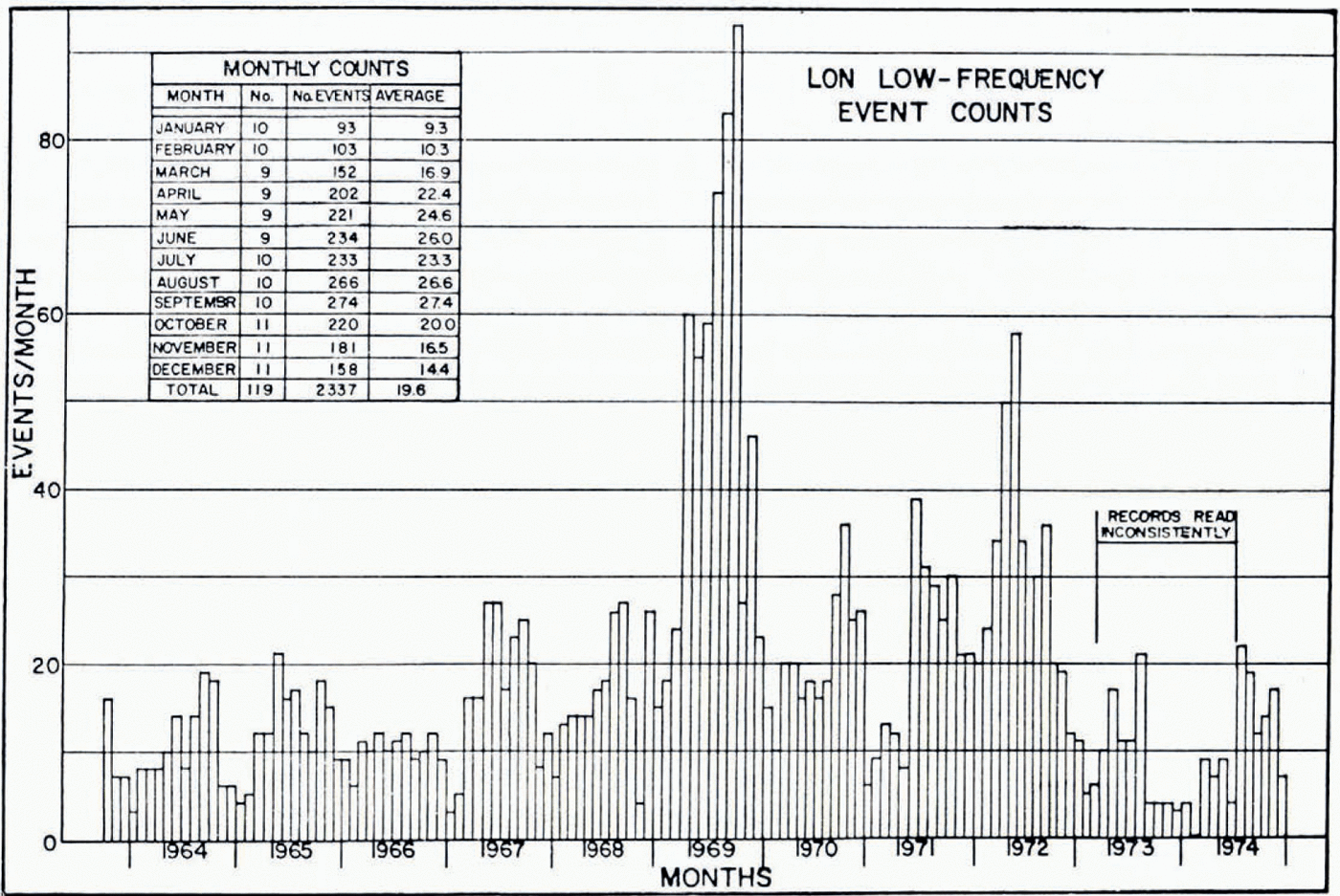
Fig. 5. Monthly event counts at Longmire (LON), the permanent station on Mount Rainier. The inset in the left corner shows the average monthly counts.
Glacier avalanche
In response to increased fumarolic activity in Sherman Crater of Mount Baker, the University of Washington established several seismic telemetry stations high on the mountain which have been recording continuously. Other than unusual monochromatic signals observed occasionally during the summer of 1975 (probably related to new fumaroles), virtually all of the recorded local events at these high stations appear to be glacially related. As mentioned earlier, the character of the events is similar to those attributed to glacier motion on Mount St. Helens and Mount Rainier. When these events can be located, they appear shallow with epicenters scattered over the glacier-covered section of the mountain. Like the events on Mounts Rainier and St. Helens, these events also have a seasonal fluctuation, increasing in number in the summer and decreasing in the winter. During the summer of 1975, there was a great deal of glacier motion in Sherman Crater as the glacier systems reequilibrated with new thermal sources (Reference Malone and FrankMalone and Frank, 1975). The rate of recorded glacier events was 10.2 events/h with a standard deviation of 4.1. During the winters of 1976 and 1977 the activity declined to less than 20% of this level. In subsequent summers, the average rate was approximately 7±3 events/h.
In July 1977, a massive ice avalanche involving 3 × 10⁵ m3 of ice and snow occurred in Sherman Crater (personal communication from Reference Frank, Frank, Meier and SwansonD. Frank, 1977). This avalanche was indirectly caused by heat from the new fumaroles melting a large pit in the lower part of the glacier descending from the summit of Mount Baker into Sherman Crater (Reference Frank, Frank, Meier and SwansonFrank and others, 1977). The lower parts of this once relatively smooth crater glacier began breaking up in the spring of 1975 as its support at depth was melted by the new fumaroles. During the first half year of instability there were numerous small ice avalanches involving as much as several hundred cubic meters of ice. Some of these may have caused the higher number of glacier events during the summer of 1975 relative to the two later summers. Since that summer until July 1977 there were no unusual ice avalanches and the glacier events followed the normal seasonal fluctuations in event counts.
Early on 13 July 1977, the number of glacier events began increasing, building up exponentially to a pair of very large events which occurred at about 11.20 p.m. local time (Fig. 6). The second and larger of these events saturated the seismometer located about 200 m from the avalanche for a full 60 s. Another seismograph located 6.2 km to the west was near saturation for 40 s. This event was also recorded on a station 36 km away for 30 s. It is assumed that this large seismic event was caused by the massive failure of a large part of the glacier even though the actual avalanche was not witnessed. From photographic records on 9 July and a dusting of snow on 17 July on top of the avalanche debris, we have, independent of the seismic data, bracketed the time of the avalanche. During this week period there is no seismic evidence for large-scale ice motions other than that of 13 July.

Fig. 6. Rate of activity recorded on Mount Baker station LLB, 200 m from the avalanche area. Plotted are the number of events with peak-to-peak amplitudes greater than 5 mm on a helicorder record per half-hour interval. Symbol × represents an event with a star.
Immediately following the large seismic event at 11.20 p.m., the seismic activity virtually stopped. Figure 7 shows a section of a record from the Sherman Crater station for the 12 h preceding the large event and for several hours after it. Note the increasing numbers and sizes of events before the main events and comparative quiet following it. The post-event period is typical of the activity level for most of the rest of the summer.

Fig. 7. Helicorder record for the Sherman Crater avalanche. Time marks at 1 min.
Seimic energy release
The amount of seismic energy released during the generation of a glacier event has direct implications on both the source size and duration time, and offers a strong constraint on the nature of the source. Two independent measurements of seismic energy show that the Cascade glacier events involve many orders of magnitude more energy than that associated with crevassing on Athabasca Glacier (Reference Neave and SavageNeave and Savage, 1970). One method used on Mount Rainier is to determine the magnitude of a glacier event, and then calculate the energy using an empirical relation between magnitude and energy. Magnitudes were calculated in two ways. For a number of years, a Wood–Anderson torsion seismometer was operated at the permanent station site on Mount Rainier and, though a lower gain instrument, it did record some of the larger Mount Rainier events. The Wood-Anderson system was initially used to develop the Richter earthquake magnitude scale (Reference RichterRichter, 1958) and, applying the same amplitude and period criteria to the Mount Rainier data, gave a Richter magnitude of 2.7 for the larger events. A second magnitude scale using the average coda length of the event (and ultimately related to Richter magnitudes) as recorded at several stations was developed for western Washington (Crosson, 1972) and, using this relation, magnitudes ranging between 1.2 to 2.4 were calculated for events recorded in 1972. The larger events seem certain to be this large, since they were detected over an area roughly 65 km by 50 km. Using the Gutenberg–Richter magnitude–energy relation (Reference RichterRichter, 1958) gives the energy release for the larger Mount Rainier events as between 105 and 109 J. This compares with one joule calculated for crevassing on Athabasca Glacier by Reference Neave and SavageNeave and Savage (1970).
A second method of obtaining an energy estimate is by comparing event codas from the 1974 Mount St. Helens stations with codas obtained from explosions (see Fig. 3; Reference Weaver and MaloneWeaver and Malone, 1976). As discussed by Reference Weaver and MaloneWeaver and Malone (1976), the basic characteristics of the low-frequency coda could be duplicated by placing an explosive charge at the ice–rock interface. Following Reference ColeCole (1965), the available seismic energy can be calculated from the characteristics of the seismic explosive, the weight of the explosive, and efficiency at which energy is actually radiated as seismic waves. Investigations on strain energy released by explosions (Reference Fogelson, Fogelson, Duvall and AtchisonFogelson and others, 1959) showed that between 5 and 9 % of the total energy released by an explosion is transferred to the surrounding media and this percentage may be higher if the cavity is partially filled with water (Reference ColeCole, 1965). Using a seismic efficiency of 5 % probably quite reasonable for shots near the ice–rock interface since the holes were always water-filled, gives an estimate of 2.5×10⁴ to 2.0×10⁵ J for the shots on Mount St. Helens, and the smaller glacier events are likely to be on the same order.
Seismic properties at the ice–rock interface
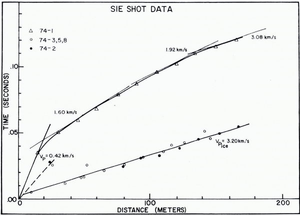
The seismic compressional wave velocity in Nelson Glacier was determined from five refraction shots recorded on the SIE array and station CRV (Fig. 2). Four of the shots were in glacier ice and one shot was located near geophone G-1 on rock. Results from the four ice shots showed a very precisely determined compressional wave velocity of 3.20 km/s (Fig. 8, lower curve). Note the relatively small scatter of the points about the indicated velocity. The upper trace in Figure 8 reflects the much lower compressional wave velocity in the near-surface rock at the tip of the “Dogshead” (0.40 km/s); as the initial rock path becomes increasingly less significant with increasing distance across Nelson Glacier, the velocity calculated at three tangent points begins to approach the ice velocity.
The very low near-surface rock velocity indicated in Figure 8 was observed over the entire 1974 experiment area, although on this larger scale the velocities tended to be higher— 0.8–1.50 km/s (Reference Weaver and MaloneWeaver and Malone, 1976). Nevertheless, the velocity contrast between the ice and the rock is still very large, and this contrast results in two distinct seismic properties. First, the ice–rock system forms a seismic low-velocity zone, resulting in a low-velocity shadow effect (Reference Weaver and MaloneWeaver and Malone, 1976). Secondly, the large velocity contrasts favor low seismic-energy transmission across the ice–rock interface. In addition, the steep slopes of the mountain make subglacial cavitation at the ice–rock interface very likely (Reference KambKamb, 1970), resulting in less than perfect elastic coupling between the ice and rock (i.e. non-welded contact), fruther reducing transmission efficiency. The glaciers on Mount St. Helens are thus seismically decoupled from the underlying rock layers; they are seismically floating on the rock.

Fig. 8. Travel-time data from the SIE array far shots fired in ice (74-2, 3, 5, and 8) and on rock (74-1). Velocities on the upper, curve refer to that calculated along the three tangents.
This decoupling explains the monochromatic coda at station CRV (Fig. 3) but not seen at a station only 67 m away on rock (DOG). The coda represents a trapped SV wave, reflecting at the rock–ice boundary and at the air–ice boundary. The frequency of this monochromatic coda implies a glacier thickness of about 30 m assuming it is the fundamental mode of totally internally reflected SV waves. A similar phenomenon was observed by Reference CraryCrary (1954) on floating ice islands in the Arctic, although Crary used artificial sources while the Mount St. Helens waves are produced by natural glacier action.
Discussion
The large number of glacier events on the helicorder record in Figure 3 are likely the result of several different glacier sources. There is little doubt that some of the events are the result of surface glacier actions: serac collapse, ice avalanches, and the like. Based on the seismic evidence (locations, event counts, energies, and event character), there is ample evidence to conclude that the larger glacier events must be generated by a different class of sources. All attempts to correlate observed surface glacier activity with seismic traces produced the same result; only at the recording station nearest the observation could some form of audible noise be correlated with activity on the seismic records. Further, as mentioned above, based on the work of Reference Neave and SavageNeave and Savage (1970) on Athabasca Glacier, crevassing does not appear to involve enough energy to explain the observations. Consequently, other sources are necessary to explain our seismic results.
One possibility is that the instantaneous vertical movement of volumes of ice could convert potential energy into seismic energy much like dropping a weight on the ground. Ice volumes on the order of 1010 cm3, moving approximately 1 cm vertically, with a relatively low energy-conversion efficiency of 1% could produce 105 J of seismic energy. This mechanism might be possible on thin glaciers that are cracked through their entire thickness and possibly in steep ice falls on thicker glaciers. This mechanism would seem to require special geometrical relationships between adjacent ice blocks to accommodate the need for instantaneous slip, required to produce the sharp near-field features seen on the seismograms.
A second possibility is stick–slip sliding, or discrete slip, at the base of the glaciers. In this mechanism, obstacles at the bed inhibit glacier flow, causing a local increase in the basal shear stress. A small area of ice might elastically release this stored strain energy, radiating seismic energy Es according to
where S b is the basal shear stress, A b is the slip area, d is the displacement, and e is the seismic efficiency. For a basal shear stress on the order of 1 bar (appropriate for the Cascade glaciers) and an area of 106 cm2, a displacement of 1 cm with an efficiency of 1% produces 1012 ergs of energy. As many of the Cascade glaciers are on the order of a few kilometers in area, each glacier could have the potential of thousands of seismic events.
The shear sliding mechanism is our preferred mechanism. First, as discussed by Reference Neave and SavageNeave and Savage (1970), large shear stresses are known to exist near the base of glaciers; a distinct shear zone has been observed at the base of Blue Glacier by Reference Kamb and LaChapelleKamb and LaChapelle (1964). Secondly, the proposed discrete slip would be similar to observations on the Glacier d’Argentiére. Reference Vivian and BocquetVivian and Bocquet (1973) used a hydroelectric water-collection tunnel drilled under the Glacier d’Argentiére in the French Alps to observe the behavior of the glacier bottom. Their observations of the basal ice movement showed a jerky history, with large variations in the daily movement. The average daily movement varied from 5.0 cm/h in June and July to below 2.5 cm/h in winter. During some observation periods, the motion of the glacier measured in the cavities stopped entirely, with the stopping time ranging from a few hours to 3 d. The observations outlined by Reference Vivian and BocquetVivian and Bocquet (1973) suggest a discrete slip mechanism with a seasonal variation similar to that seen in the glacier events in the Cascades. It seems plausible to speculate that the annual cycle is related to the amount of water reaching the glacier base, and this should be a maximum sometime during the summer period.
Finally, the event counts associated with the ice avalanche on Mount Baker deserve further comment. The avalanche involved massive failure of the glacier on its base, and it is likely that many of the detected events involved preliminary basal sliding. This set of observations is also important because it suggests that seismic monitoring may be a viable method of predicting glacier avalanches. The avalanche on 13 July 1977 is probably one of the larger to occur in the Cascádes. Because the accumulation zone was entirely within the rarely visited Sherman Crater, the hazard potential from a repeat event is very low. There are, however, other glaciers in the Cascades and elsewhere whose massive failure could present considerable hazard. The potential for seismic warning systems is obvious. In the case described here, an alert observer would have suspected something unusual fully 12 h prior to the event, and there would have been no mistaking the trend 3 h before the event. It is conceivable to automate a warning system based on event rate or energy-release rate if the need for public warning is high enough. A seismic monitoring program might also be effective in forecasting the beginning of glacial surge episodes. In view of the Mount Baker evidence, it seems reasonable to conclude that the large increase in glacier events on Mount Rainier in 1969 is directly related to the mentioned break-up of Emmons Glacier. Unlike Sherman Crater glacier, however, no catastrophic avalanche occurred on Mount Rainier.
Discussion
W. H. Mathews: From your data on Mount St Helens, can you identify by first-motion studies the orientation of the shear surfaces at which the events originated ?
S. D. Malone: We attempted to do focal-mechanism studies on several events but the complexity of the velocity structure makes it difficult reliably to determine take-off angle from the source. This means there can be a great deal of ambiguity in any solution attempted. We felt because of these ambiguities and the sparseness of the data that no reliable solutions were possible. We saw polarity reversals at different stations for the same event, indicating that these particular events were from a shear-type source.
N. Deichmann: The short high-frequency signal recorded on the SIE refraction array seems quite different from all the others. From the similarity to the signals recorded by Neave and Savage on Athabasca Glacier and by myself on Unteraar, I would suggest that it originated from crevasse formation near the surface. Since the glacier thickness is only about 50 m, your determination of its focal depth could also place it in the crevassing zone given by Neave and Savage.
Malone: I agree that it is possible that the event I showed was a crevasse-generated event. There is someevidence, albeit circumstantial, that at least some events originate from the ice–rock interface. For example, some of the events recorded on the SIE were also recorded on the network stations and suggested equal energy partitioning between rock and ice.
S. M. Hodge: Have you tried to correlate any of the peaks in activity at Mount Rainier with jökulhlaups? It seemed to me the second largest peak occurred in 1972, when there was a jökulhlaup from Nisqually Glacier.
Malone: I have not looked for a correlation with jökulhlaups but I wouldn’t be surprised if such a correlation existed. The highest peak was in 1969 and I have heard reports indicating that Emmons Glacier became badly crevassed during that summer.
G. De Q. Robin: I will be reporting similar types of activity, but at lower frequency, from observations beneath Glacier d’Argentiére, in a later paper. Conclusions are similar. Can I ask if the authors found any diurnal variation in the intervals between events on Mount St Helens?
Malone: There are no obvious periodic variations in the data, in particular, in the range around the diurnal period. Since we saw no obvious periodicity, we did not attempt an elaborate spectral analysis.
R. C. Metcalf: I just have a comment to add glaciological credence to your seismic results. You have mentioned that seismic energy release in icequakes that you observed is in the range 103–107J, and in another paper (Reference Weaver and MaloneWeaver and Malone, 1976), that these low-frequency events occur about once a minute. My calculations show that for a similar glacier on a similar bedrock (Nisqually Glacier on Mount Rainier) the mean basal sliding energy dissipated in one month over a bed area of 1 000 m2 is 6 × 10³–2.4 × 10⁴ J and for an area of 1 km2 is 6 × 10⁶–2.4 × 10⁷ J, in excellent agreement with your results.