


The Editor,
Journal of Glaciology
Sir,
Snow cover in the mountainous areas of the Cordillera Cantábrica has recently diminished due to very low precipitation in recent years. These conditions have made it possible to continue the monitoring of glacier ice in the Jou Negro, located in the karstic area of the Picos de Europa. Low snow cover has revealed the full dimensions of this ice mass, the characteristics of which indicate a glacier origin.
Glaciar Jou Negro was previously visited in September 1992 and the results of the observations were published in a previous note (Reference González Suárez and AlonsoGonzález Suárez and Alonso, 1994). This earlier work pointed out that Iulure Surveys would make it possible to determine whether the glacier was stable or retreating. Reference Frochoso and CastañónFrochoso and Castañón (1995) replied to this note saying they disagreed with most of the observations made on Glaciar Jou Negro, considering different small ice bodies, with no layers and a possible periglacial origin. For these authors, the use of the term glacier was also inadequate. However, the firn layer at the time of their visit was thicker than in September 1992, as shown in their photograph. For that reason, it is unlikely that they were able to make detailed observations of the ice.
The purpose of this note is to provide new data in order to clarify our previous conclusions and to reply to the opinions of Reference Frochoso and CastañónFrochoso and Castañón (1995) with regard to the presence of glacial ice in the Jou Negro.
Glaciar Jou Negro
During recent years, decrease in snowfall in the Cordillera Cantábrica has been considerable. 1995 has been an especially dry year. In the mountainous regions, permanent snowfields, usually occurring in low insolation zones at the end of the summer, have been drastically reduced. Therefore, at the end of the summer of 1995, the snow-covered area in Glaciar Jou Negro was much smaller than in 1992. In 1995, loss of snow cover was so extensive that a large ice surface was exposed, making possible a detailed survey of the glacier, including direct ground measurements, exploration of conduits and debris-marking for future controls.
Glacier ice, with stratified debris layers, is exposed in most of the area between the moraine and the cirque walls. Other parts are covered by firn or debris (Fig. 1). Snow cover occurs in the eastern part, close to the back wall and in a small frontal band next to the terminal moraine. Surficial debris, tending to occupy the central third and frontal zones, constitutes a continuous covering formed by scattered clasts. In the debris-covered area, seven vertical shafts (moulins). caused by wet precipitation and surface meltwater, were found. Ice thicknesses of between 7 and 14 m were directly measured at different points, by descending some of the moulins (Figs (2) and (3)).

Fig. 1 Glaciar Jou Negro on 1 November 1995 showing banded ice. Firn coverning is restricted to the southeastern part of the glacier. Previous upper-ice limit is clearly outlined on the back wall. Torre de Cerredo summit 2651 m, on the left.
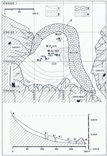
Fig. 2 Surficial map, obtained by direct measurements, indicating altitudinal references, dimension of the glacier, position of the moulins and real ice thickness. Stippled area corresponds to the photograph in Figure 4. Legend: 1. Glacier ice; 2. Rock wall; 3. Moraine; 4. Debris-mounds area; M.P. Main ponor (stream sink).

Fig. 3 Exposure of glacier ice, with stratification dipping up-glacier, at the entrance of moulin number 5 (7 November 1995).
Using topographic data, it is possible to estimate for the glacier ice an approximate surface of 2.5 × 10⁵ m3, with a length of 190 m in the central pan and a maximum width of 170 m. From these data, ice volume can be calculated as about 2 × 10⁵ m3.
Total exposure of the Glaciar Jou Negro ice, like that at the end of the melt season, in the autumn of 1995, is not possible at the beginning of summer or in years with higher precipitation, when only debris mounds emerge, surrounded by snow. This circumstance could have made Reference Frochoso and CastañónFrochoso and Castañón (1995) think that there were several, small fossil ice bodies. There is, on the contrary, one continuous body of glacier ice from the cirque back wall to the frontal moraine (Fig. 4). At present, this glacier constitutes a cryokarst (or glacier karst, with forms similar to those developed in limestone areas). Waters of supraglacial and englacial drainage, part of the wider domain of the large karstic depression of Glaciar Jou Negro, feed the glaciokarst beneath the ice. It was impossible to observe proglacial drainage, as the area in front of the moraine constitutes the jou Footnote * bottom, which is partly filled with large boulders.

Fig. 4 Covered ice around moulin number 5 showing debris mounds, usually isolated and surrounded by firn at the end of the summer (7 November 1995).
Aerial photographs from 1969 show a darker area in the firn, interpreted by Reference Frochoso and CastañónFrochoso and Castañón (1995) as ice similar to that described in 1992 by Reference González Suárez and AlonsoGonzález Suárez and Alonso (1994). This darker area is, however, a zone of the firn with a higher water content. It also corresponds to a depression, at a position close to the moraine, where in 1995 the main ponor (stream sink) was found. In addition, when the firn cover diminishes, the first zone where the glacier is exposed is located adjacent to the back wall, as shown in the photograph taken in 1992.
With regard to the use of the term “glacier”, some authors consider the present movement to be a condition for giving that name to a mass of ice, whereas others suggest movement can be present or past. The Glaciar Jou Negro ice, in accordance with the available data, displays the morphological characteristics of a receding glacier. The recent maximum extent of the glacier, shown by the moraine, probably occurred during the Little Ice Age. as in the Pyreuean glaciers (Reference Serrat and VenturaSerrat and Ventura, 1993), Since then, ablation has caused an important surface down-wasting rather than a terminus retreat, leading to a reduction in volume and thickness. At the front, the present glacier surface is 10 m lower than the toр of the moraine. This situation seems to be similar to that of the glaciers of the Pyrenees which are clearly in a receding phase increased, in recent years, by a reduction in snow precipation and thermal insolation, which explains the recently observed glacier-mass loss (Reference Arenillas, Cantaritino, Martínez, Martínez de Pisón and PedreroArenillas and others, 1992).
Furthermore, Reference Martínez de Pisón and Arenillas ParraMartínez de Pisón and Arenillas Parra (1988) included some glacierets in their catalogue. As these glacierets do not have crevasses, they do not consider them as glaciers, although they are remnants of previous ones (e.g. Punta Zarra glacieret). Likewise, a report of the Ministero de Obras Públicas y Transpones (1992) on the snow in the Spanish cordilleras includes some glaciers in the Spanish Pyrenees with dimensions similar to Glaciar Jou Negro, such as those of Punta Zarra, Balaitus and Taillón. All of them, located in the western part of the glacierized area, are small-size glaciers with an area of 2 × 10⁴ m2. Regarding thickness, Glaciar Jou Negro is thicker than those in that report, the real values reaching 14 m at some points.
The presence of isolated glacier ice in the Picos de Europa is probably due to its slower response to recent climate changes due to the specific characteristics of its location, above 2200 m and with a northeast aspect and a shady topography, as it occupies an important karstic depression. Future research concerning the stage of evolution is planned and this includes the measurements of possible variations in ice thickness and in glacier extent, as well as modifications to the water-conduit system.
Acknowledgements
Field assistance and topographic work, carried out by J. Alonso Peña, is gratefully acknowledged by the authors.


