


Introduction
Recent glacier investigations indicate that surging glaciers occur in several parts of the world. A series of air photographs document an exceptional advance of a nameless glacier in Stauning Alper in East Greenland (Reference Henriksen and WattHenriksen and Watt, 1968). Photographs taken in 1947 and 1950 show that the glacier had not changed during this time interval but those taken in 1961 and 1967 show a rapid advance of 3 and 7.5 km, respectively. However, the glacier reached the fjord in 1967 so that the photographs do not allow one to calculate the entire distance of the surge (Reference Oleson and ReehOleson and Reeh, 1969). The other glaciers in the same region show, for this period of time, a general diminution in their size.
As a member of an expedition of the Grønlands Geologiske Undersøgelse to East Greenland in the summer of 1969, the author had (he opportunity during geological field mapping of visiting several glaciers and also observing them from a helicopter. Detailed investigations were made on BJørnbo Gletscher, one of the largest in the Stauning Alper (Fig. 1). It is a valley glacier which is completely independent of the inland ice sheet. From the map (Fig. 3) we have the following details: Position, lat. 71° N., long. 25° W.; length, 35 km; approximate elevation of the firn limit (air photograph 14 July 1968), 1 000-1 100 m a.s.l; surface area, 260 km2; accumulation zone, 184 km2 (71%); ablation zone, 76 km2 (29%).

Fig. 1. Map of part of East Greenland.
The medial moraine patterns in the ablation zone are quite distinct, especially the two drop-like moraine patterns on the southern side of the glacier (Fig. 2). Similar forms are known from surging glaciers, for example, Tikke Glacier in British Columbia and Susitna Glacier in Alaska (Reference Meier and PostMeier and Post, 1969). The fact that a surging glacier has already been observed in Stauning Alper and that the medial moraine patterns of Bjørnbo Gletscher appear very similar to those on well-known surging glaciers leads the author to believe that Bjørnbo Gletscher is a surging glacier. Evidence to support this belief will be given in the following sections. The problem is to determine the dynamics of the glacier from its present static form.
Field Methods
In the present case, it is possible from the static model of the glacier to tell something of its dynamics if several areas in the ablation zone are correlated with corresponding areas in the accumulation zone. The connection between these two zones is the medial moraine, which makes clear the junction of two separate ice masses of different origins. The site of the junction between these two ice masses always contains debris derived from the ridge separating the two accumulation zones. This debris forms the medial moraines found in the ablation zone. This junction between the two different ice masses is not visible in the accumulation zone, and therefore the correlation between corresponding areas in the accumulation and ablation zones is difficult. Therefore, the debris from the medial moraines in the ablation zone has been compared with rocks occurring in the upper part of the glacier. The debris of these medial moraines is correlated with the rocks occurring on the various ridges which separate the several accumulation zones from each other. If the rocks from the different accumulation zones are highly variable, it is possible to fix the origins of the medial moraines in the accumulation zone by a study of the debris of the moraines. By this method it has been possible to obtain much information concerning the correlation between the ablation and accumulation zones on Bjørnbo Gletscher.

Fig. 2. The langue of Bjørnbo Gletscher; a composite of two vertical air photographs taken m 1968.
Geological Environment Of BjØrnbo Gletscher (Fig. 3)
Stauning Alper belong geologically to the “Central Metamorphic Complex”, an integral part of the Caledonian orogenic belt in East Greenland (Reference HallerHaller, 1958). During the Caledonian orogeny, a young Precambrian-Ordovician geosynclinal sequence in central East Greenland was transformed into migmatitic rocks. The migmatitic lower part played an active part in the folding and it exhibits many igneous rocks whose parents are the migmatitic rocks themselves. Such igneous rocks are very common in Stauning Alper.
The surroundings of Bjørnbo Gletscher are characterized by three rock types. First, on the eastern side of the Stauning Alper fault there are sediments, predominantly arkoses, which are unimportant in this investigation. Secondly, there are migmatites which comprise the largest proportion of the rocks. Thirdly, there are the igneous rocks which are associated with the migmatiles. The petrographie relations of the debris in the moraines to the two latter groups is clear. Both of these groups can be subdivided, each having its own characteristics. Hence, for the erratic boulders there are several different sources with different rock types which enable the provenance of the morainic debris found in the ablation zone to be determined.
Migmatitic Erratics
The migmatitic rocks are divided into migmatites without special characteristics (migmatites s.l. ) and stromatites; only the latter crop out on the upper part of the firn of Bjørnbo Gletscher. There are also nebulitic biotite-bearing migmatite-granites and quartz-bearing hornblende-syenites, which have no distinct contacts with the migmatites.
Erratics Of Special Rock Types Found In The Migmatites
The most remarkable rocks are the marbles and the calc-silicate rocks which transgress the migmatites as ribbons. Isometric bodies such as dark metapyroxenites and meia-amphi-bolites also occur in the migmatites, and these, like the nebulitic biotite-bearing migmatite-granites, are unimportant to the present investigation.
Erratics From The Special Formations In The Migmatites Along The Contact With The Homogeneous Rocks
Along their contacts, the migmatites have been transformed in a rather special manner. They become more and more cordierite-bearing xenolith-migmatites, which are transformed near the contact with the igneous rocks into dark biotite-rich migmatite-gneisses. The boundaries between these rocks, the nebulitic biotite-bearing migmatite-granites and the quartz-bearing hornblende-syenites are not sharp although they have been drawn so on the map.
Granitic Erratics
Sharp contacts cannot be found in the homogeneous granitic area in the firn zone. From south to north, hornblende-syenites are transformed into biotite-granites and porphyritic biotite-granites.
Summarizing, the following erratic rock types can be distinguished: migmatites without special characteristics (migmatites s.l. ), stromatites, nebulitic biotite-bearing migmatite-granites, quartz-bearing hornblende-syenites, marbles, calc-silicate rocks, metapyroxenites and meta-amphibolites, cordierite-bearing xenolith-migmatites, dark biotite-rich migmatite-gneisses, hornblende-syenites, biotite-granites, and porphyritic biotite-granites.
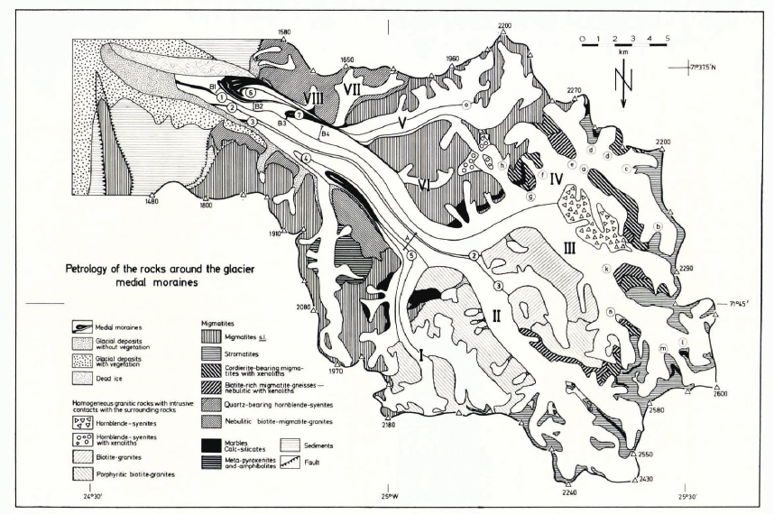
Fig. 3. Map of Bjørnbo Gletscher and the geology of the environs.
Correlation between the ice masses in the ablation zone and those in the accumulation zone by means of the petrographic relationship between the debris of the medial moraines and that of the rocks surrounding the glacier in the upper region (Figs. 3 and 4)
Along profile A, in medial moraines 2-5, the following debris has been observed (Fig. 3): moraine 2, only clear, medium-grained biotite-granite; moraine 3, the same as moraine 2; moraine 4, migmatites s.l, marbles, calc-silicate rocks and porphyritic biotite-granites; moraine 5, only porphyritic biotite-granites.
Because medial moraines 2,3 and 4 can be followed up lo their origins, correlation within profile A is easy (Fig. 3). The ice masses which lie in the ablation zone north of media! moraine 2 have been formed in fini fields I and II (without consideration of the northern tributary).
Medial moraine I contains only a red-coloured hornblende-syenite. Although its course is not now visible in the firn zone, its origin must be near the small outcrop of hornblende-syenite (Fig. 3). Medial moraine I enables a further correlation to be made. The ice masses which lie in the ablation zone between medial moraines 1 and 2 have been formed in firn field III. The investigation of the small medial moraines k, l, m and n validates the previous results. The composition of these moraines is as follows (Fig. 4): moraine k, only dark biotite-rich migmatite-gneisses; moraine l, only stromatites; moraine m, only stromatites; moraine n, dark biotite-rich migmatite-gneisses, stromatites and specific xenolith-migmatites. The debris of the small medial moraines k, l, m and n can be correlated with the rocks of the ridges which divide firn zone III into several parts. The origins of medial moraines k, l, m and n are marked in Figure 3 with the corresponding letters.
Furthermore, the small medial moraines a-h south of the characteristic moraine 1 along profiles Bi, B2, B3 and B4 have been examined. Their compositions are as follows (Figs. 3 and 4): moraine a, only cordierite-bearing xenolith-migmatites; moraine b, predominantly stromatites, cordierite-bearing migmatites, isolated boulders of hornblende-syenite; moraine c, predominantly stromatites; moraine d, stromatites, cordierite-bearing xenolith-migmatites, dark biotite-rich migmatite-gneisses (near d can be found two moraines with the same boulders); moraine e, predominantly dark biotite-rich migmatite-gneisses; moraine f, predominantly cordierite-bearing xenolith-migmatites; moraine g, marbles, calc-silicate rocks, dark biotite-rich migmatite-gneisses, cordierite-bearing xenolith-migmatites; moraine h, migmatites s.l
Moraines a—h are very different from one another in the type of debris they contain. The same profile can be seen at B1, B2, B3 and B4, although the lateral distances between the moraines vary by very large amounts (Figs. 3 and 4). It is possible to reconstruct the origins of these moraines after a comparison between the morainic debris and the rocks occurring in the firn zone. These origins are indicated in Figure 3 by the appropriate letters. Similar investigations have been carried out on the drop-like ice masses 6 and 7, which are bounded by medial moraines (Fig. 4).
Moraine q forms the northern boundary and two involute moraines form the southern boundary of 6. These three moraines come close together, forming a thin tail towards the up-glacier side of the ice drop. The debris-free ice mass at 6 is crossed by the small moraines p and o. The minute detail at moraine p is remarkable. This moraine consists of two parts, the southern showing a sub-division into three parts over a short distance. The difference in the type of debris carried is not as great as between the other moraines. Nevertheless, slight differences can be found in a profile across tributary V. The large moraine q is composed of migmatites on its southern side, whereas on the northern side there are hornblende-syenites and biotite-granites. It can be followed up-glacier to its origin in the side of valley V. The small moraine i, which lies to the north of q is composed of hornblende-syenites with xenoliths. Its origin is the small isolated hornblende-syenite outcrop between firn zone IV and tributary V (Fig. 3). It can be followed between q and 7, but on the north-western side of tributary V it is covered by a rock slide. Both of the drop-like medial moraines which form the southern margin of 6 are composed predominantly of quartz-bearing red-coloured hornblende-syenites, which give the moraines a noticeable colour. Finally, the drop-like moraine at 7 consists predominantly of migmatttes s.l.

Fig. 4. Map of the tongue of Bjørnbo Gletscher.
From the above, the following relationship between the ice masses in the ablation zone and the firn zone (Figs. 3 and 4) can be deduced. Medial moraine I separates Bjørnbo Gletscher into southern and northern parts. Using profile A, it has been possible to correlate the ice masses in the ablation zone to the north of I with the corresponding ice masses in firn zones II and III. For the southern part, profiles B1, B2, B3 and B4 are very important. The relationship between the debris of the moraines and the rocks occurring around the firn field has already been discussed. The small moraines shown in profiles B1, B2, B3 and B4 can be followed continuously; therefore, it is proven that the ice masses between the drop-like moraine patterns 6 and 7 and moraine I have their origin in firn zone IV. In other words, ice masses 6 and 7, which are bounded by drop-like moraine patterns, are inserted parts (in the sense of Reference SharpSharp (1948)) of the main glacier. If these ice masses had been situated on top at the main glacier, the small moraines a-h would be covered by 6 and 7. There is still the question of the origin of ice masses 6 and 7. The main part of 6 comes from tributary V and the small red-coloured quartz-bearing syenite parts of 6 have their origins in VII and VIII. Finally, the debris at 7 proves that this ice mass came from VI.
Solution Of The Glacier Dynamics From The Static Model
The debris-bearing medial moraines prove that ice masses 6 and 7 are inserted parts of the main glacier. The growth of the drop-like form can be explained by a single glacier advance from the tributaries. Today, tributaries V-VIII are completely static. Air photographs taken in 1951 and 1968 show that the main glacier has not changed for 17 years. If two identical points on both the vertical photographs of 1968 (Fig. 2) and the oblique photographs of 1951 (Fig. 5) are joined across the glacier, the straight line crosses the non-changing glacial river at the same place north of moraine I. Even the forms and courses of the medial moraines have not been changed; at most they have become even more clearly visible. Both the tributaries and the main glacier are static today. An advance from the glacier tributaries V-VIII into the main glacier, which has happened only once, occurred at the same time as the growth of the main glacier. The dynamics of this glacier are the same as those of a surging glacier. A quiescent phase alternates with an exceptionally large advance of the glacier which can be called a surge. The duration of the quiescent and the moving phases can be estimated. The main movement of 7.5 km of the well-known nameless surging glacier in Stauning Alper lasted 6 years (the duration of the glacier advance of 3 km is not known). Meier and Post (1969) have given similar times; less than 1 year to about 6 years and most commonly 2-3 years have been reported elsewhere, and a similar time interval for Bjørnbo Gletscher can be expected.
The distance of the surge can be measured as follows. The distances A, B and C from the fronts of the drop-like moraine patterns to the farther sides of the ends of the tributaries are the same (Fig. 6). The same distance can be measured from the peculiar laterally thickened part, which is marked by the folded blue bands (Fig. 5), in the main glacier headward to the origin of this trunk glacier at the margin of firn field II (D in Fig. 6). It is assumed that the inducing mode of action for the overall movement of Bjørnbo Gletscher is that of a glacier flowing from firn field II. Because firn field II is much larger than either V or VI, there is not only drop-like ice-mass insertion into the main glacier during the surge, instead, during the surge there is continuous injection of ice into the main glacier from firn field II. Although the distance D consists of ice from one source, its length still corresponds to the lengths A, B and C. The amount of the surge is determined by the distance D, which is 10 km. If it is assumed that the glacier snout, after the last surge, arrived at the area which is marked by-glacial deposits without vegetation (Fig. 3), the time from the last quiescent phase can be estimated. Before the last surge, the snout was 10 km up-glacier of the junction (1 in Fig. 6) between the glacial deposits without vegetation and those with vegetation. Point E (Fig. 6) represents the highest surface level of the glacier just after the last surge and this is marked today by the junction between vegetation and no vegetation (Fig. 2). Point F (Fig. 6) is on the surface of the glacier today. Point E (630 m) and point F [470 m) have been measured with an altimeter. The difference in height between the glacier surface after the last surge and the glacier today is 160 m. The ice thickness has been measured from moulins as 40 m. There is then a difference in altitude of 200 m between the glacier surface after the last surge and the bottom of the glacier at point F. The annual ablation can be calculated approximately. For 10 days our tents were pitched on ice in the ablation zone and therefore this ice had been protected from ablation. The ice deflation after 10 days was 0.30 m. Calculated from an ablation period of 2 months, an annual ablation of about 2 m can be assumed. Therefore, it would require 100 years to melt the glacier ice at point F (Fig. 6).Reference Meier and PostMeier and Post (1969) have assumed a period of between 15 years and more than too years for the quiescent phase of a surging glacier, indicating that 20-30 years appears to be the commonest time for the duration of the quiescent phase. From the above estimate, it is highly likely that the quiescent phase is much longer than the movement phase.

Fig. 5. Oblique air photograph of the upper par! of Bjøribo Gletscher, taken in 1951.

Fig. 6. Schemalk map of the tongue of Bjørnbo Gletscher.
Conclusions
The dynamics of Bjørnbo Gletscher are characterized by a present-day quiescent phase which can be proved from air photographs. In a short surge of the main glacier, ice masses from the tributaries in the ablation zone became inserted into the main glacier. The ice surge from the side valleys has not been as long as the movement of the main glacier. In this time the glacier advanced about 10 km. It is assumed that the snout reached the boundary between the glacial deposits with vegetation and the glacial deposits without vegetation, which is clearly visible on the air photographs. The course of the advancing snout has been diverted by a dead ice-mass which originated from a former surge. This dead ice should not be related to the ice from the last surge. The distinction between the two surges can be found in the diverted moraines of profile B along the margin of the dead ice-mass. The duration of the quiescent phase has been calculated as 100 years. Since the last surge occurred in 1890, it can be expected that the next surge will occur around 1990.
Acknowledgement
I wish to thank Mr John Purdy for his assistance with the translation of this paper.


