


1. Introduction
The margin of the Greenland ice sheet has undergone rapid changes over the past decade, most notably the thinning, acceleration and retreat of many fast-flowing, marine-terminating outlet glaciers. Long-term thinning of ice at floating and grounded marine fronts prior to 2000 (Reference KrabillKrabill and others, 1999, Reference Krabill2000) may have led to destabilization and sudden retreat of glaciers around the coast (Reference Joughin, Abdalati and FahnestockJoughin and others, 2004, Reference Joughin2008a; Reference Howat, Joughin, Tulaczyk and GogineniHowat and others, 2005, Reference Howat, Joughin, Fahnestock, Smith and Scambos2008; Reference Rignot and KanagaratnamRignot and Kanagaratnam, 2006; Reference Moon and JoughinMoon and Joughin, 2008). Breakup of confined, floating ice tongues and retreat of grounded ice reduces resistive stress acting against flow, leading to accelerated ice flow speeds and discharges (Reference ThomasThomas, 2004; Reference Howat, Joughin, Tulaczyk and GogineniHowat and others, 2005, Reference Howat, Joughin and Scambos2007, Reference Howat, Joughin, Fahnestock, Smith and Scambos2008; Reference Nick, Vieli, Howat and JoughinNick and others, 2009). Acceleration during and following retreat has been observed at fast-flowing glaciers in all regions of the ice sheet since 2000 (Reference Joughin, Smith, Howat, Scambos and MoonJoughin and others, 2010). Increased flow rates due to retreat doubled the ice sheet’s contribution to sea-level rise between 2000 and 2005 (Reference Rignot and KanagaratnamRignot and Kanagaratnam, 2006).
Variations in glacier shape and speed may be highly variable at sub-decadal timescales, in response to both ice dynamics and climate variability. For example, most glaciers in southeast Greenland accelerated between 2003 and 2005, but then slowed by 2007 due to dynamic readjustment to the initial stress perturbation caused by retreat (Reference Howat, Joughin and ScambosHowat and others, 2007, Reference Howat, Joughin, Fahnestock, Smith and Scambos2008; Reference JoughinJoughin and others, 2008a; Reference Nick, Vieli, Howat and JoughinNick and others, 2009). Reference Moon and JoughinMoon and Joughin (2008) measured front positions of over 200 glaciers around the ice sheet in 1992, 2000, 2006 and 2007. They found that most glaciers retreated between 2000 and 2006, an anomalously warm period throughout Greenland. Retreat slowed, however, changing to advance in the southeast region during a cool year in 2007. Other evidence suggests that sustained retreat can be initiated by a single year of ocean and/or atmosphere forcing (Reference Howat, Box, Ahn, Herrington and McFaddenHowat and others, 2010). Over the past century, there have been variations of similar magnitude in both air temperatures and front positions at individual glaciers, including general warming and glacier retreat since the Little Ice Age (Reference WeidickWeidick, 1991; Reference Csatho, Schenk, van der Veen and KrabillCsatho and others, 2008; Reference Box, Yang, Bromwich and BaiBox and others, 2009). A longer-term perspective is therefore needed to assess the significance of recent events and their implications for future ice-sheet stability.
The ability to observe changes in the polar ice sheets over long spatial and temporal scales was greatly improved by the recent release of the United States Geological Survey (USGS) database of Landsat imagery, including every acquisition by the currently orbiting Landsat 5 and 7 satellites and archived data extending back to the 1972 launch of Landsat 1. These data provide an almost fourdecade-long record of changes in outlet glaciers around nearly the entire ice sheet, allowing a broad assessment of ice-sheet marginal change during the recent period of climate warming.
In this paper, we present decadal-scale changes in marine-terminating front position over the Landsat era to assess general changes in glacier front position on ice-sheetwide and regional scales. We then compare these changes with previous observations to investigate their relative significance. Finally, we compare both modern and historical changes to concurrent climate variability to gain insight into forcing mechanisms and potential for future changes.
2. Datasets and Methods
2.1. Landsat data
The Landsat program began with the first launch of the Earth Resources Technology Satellite (Landsat 1) on 23 July 1972 and currently consists of Landsat 5 and 7, launched on 1 March 1984 and 15 April 1999, respectively. An additional satellite, the Landsat Data Continuity Mission, is scheduled for launch in late 2012. Landsat 1–3 carried the four-band Multispectral Scanner (MSS), while Landsat 4 and 5 carried the seven-band Thematic Mapper (TM), and Landsat 7 carries the eight-band Enhanced Thematic Mapper Plus (ETM+). The MSS has a ground resolution of ∼60 m in all bands, while for the TM it is 30 m, and for the ETM+ it is 15 m in panchromatic band 8. Landsat 1–3 had an orbital revisit period of 18 days, while that of all other vehicles has been 16 days.
In the fall of 2008, the USGS made its holdings of Landsat data available to the public at no charge through a browsable, web-based ordering system (http://glovis.usgs. gov/). Data distributed by the USGS are geometrically and radiometrically corrected. Level 1T (terrain-corrected) products are orthorectified using known satellite positioning, sensor orientation, ground control and a digital elevation model (DEM) (see http://edcsns17.cr.usgs.gov/helpdocs/landsat/product_descriptions.html#nlaps_lpgs). These data have a horizontal positioning accuracy of better than 90 m. Most Landsat 5 and 7 TM and ETM+ data over Greenland are processed to level 1T (65% and 83%, respectively). Most (82%) Landsat 1–5 MSS are processed to level 1G, in which geometric corrections are only applied using satellite positioning. These data have a horizontal positioning accuracy of several hundred meters, which we improved with a tie-point co-registration, as described below.
We obtained all data available from the database at http://glovis.usgs.gov/ from 1972 through 21 July 2010 for which marine-terminating glacier fronts were visible in the browse imagery. All MSS and TM data obtained prior to 1999 were acquired, but only TM was acquired if both TM and MSS were available for a particular Landsat 4 or 5 scene, due to the higher spatial resolution of the TM. This resulted in 412 individual scenes. We acquired all ETM+ data collected in 2000 and 2010, totaling 502 and 523 scenes, respectively.
Data were obtained as GeoTiff files in Universal Transverse Mercator (UTM) projection and were converted to a polar stereographic projection with standard latitude of 70° and longitude of −45° using the conversion function in the ENVITM software package (http://www.ittvis.com/ProductServices/ENVI.aspx). Errors associated with this conversion are small (<1 m) relative to both the pixel size and the geolocation accuracy (discussed below). For MSS and TM data, individual bands were combined into a single grayscale principal component image in order to mitigate saturation and improve contrast. Individual scenes acquired in the same satellite pass were mosaicked into swaths.
The scan-line correction (SLC) system on the ETM+ failed in May 2003, resulting in null data striping, with stripes extending the scene edge, where they are 400 m wide, to ∼11 km from the scene center, where they narrow to zero width. Approximately 20% of each image is lost. These data, however, are of the same radiometric and geometric quality as the SLC-on data (Reference Markham, Storey, Williams and IronsMarkham and others, 2004). To mitigate the impact of the data stripes on our analysis, we use multiple overlapping images, from as close in time as available, and masks distributed with the images to fill data gaps (Reference Markham, Storey, Williams and IronsMarkham and others, 2004).
To reduce georegistration errors, L1G-processed data were co-registered to overlapping L1T ETM+ data acquired in 2000 using visible, stationary tie points (i.e. rock outcrops, bends in coastline, etc.) near the glacier margin. For each image, we selected at least ten points, adding more tie points until the root mean square (RMS) of the differences in tie-point locations between the L1G and L1T images did not increase with the addition of more tie points. This process resulted in the selection of 10–25 tie points. The L1G image was then warp-registered to the L1T tie-point locations using an affine transformation and bilinear resampling (Reference GoshtasbyGoshtasby, 1988). Co-registration errors between the L1T and warped L1G image were then determined from the RMS offset of stationary features. These errors are spatially and temporally random and can be as high as 200 m, but are typically <100 m.
2.2. Ice-front change mapping
We mapped the change in ice-front position between image pairs using the ‘box method’ of Reference Moon and JoughinMoon and Joughin (2008) and Reference Howat, Box, Ahn, Herrington and McFaddenHowat and others (2010). An example of this method is illustrated in Figure 1. On each image, we manually digitized (with a computer mouse) the outline of a polygon bounded on the down-glacier edge by the ice front, on each lateral side by parallel lines approximating the glacier margins, and on the upstream side by an arbitrary straight line placed inland of the minimum observed front position. This polygon was overlain on the second image, and the ice-front border of the polygon was adjusted to the new front position. The difference in the area of the polygon between successive images is the area change of the front, and the average retreat distance is obtained by dividing the area of retreat by the polygon width. This procedure yields a less arbitrary measure of front position change than the change along a center line, and captures spatially asymmetric retreat and advance.
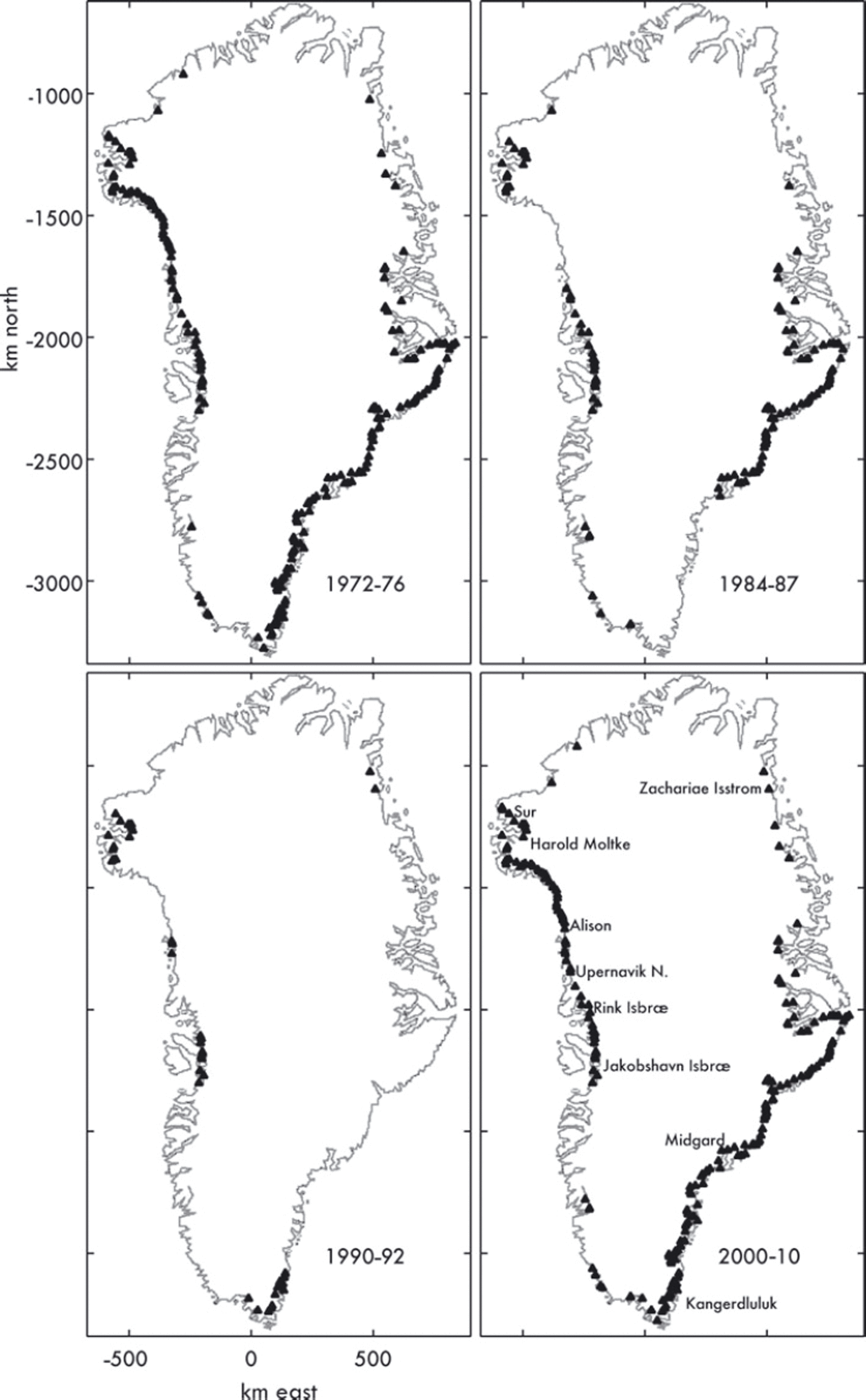
Fig. 1. Triangles denote glacier locations with at least one measurement in the indicated time period.
The primary sources of error in this measurement are (1) errors in manual selection of the front position, (2) image co-registration error due to terrain and other factors and (3) uncertainty in feature locations due to pixel resolution. The first source is difficult to quantify, but is likely substantially reduced by the averaging inherent in the ‘box method’, since the front position is sampled in many locations along the front, rather than at a single point (Reference Moon and JoughinMoon and Joughin, 2008). In some cases, the front was difficult to locate unambiguously due to the presence of semi-detached icebergs. In these cases, separate maximum and minimum positions (i.e. including and excluding the icebergs) were mapped to provide a range in estimates, which typically resulted in a difference of <0.1 km a−1 for a few glaciers. One exception, however, was Zachariæ Isstrøm on the northwest coast (Fig. 2), which underwent a break-up of its poorly defined front between 2000 and 2005 as noted by Reference Moon and JoughinMoon and Joughin (2008). The change in front position due to this break-up can vary by 1.5–2.5 km, giving a rate uncertainty of 150–250 m a−1, depending on where the front is placed. Since the total retreat was ∼1.8 km, however, this uncertainty is only 8–14% of the rate of change. Additionally, this single retreat does not have an appreciable effect on the uncertainty of the average changes in the northeast subsample for 2000–10, due to the large number of observations (N = 35).
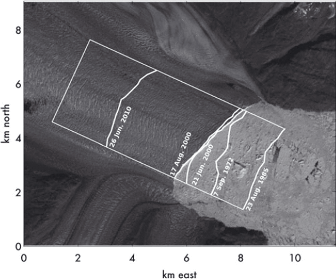
Fig. 2. Example of box method for measuring changes in front positions. The image is Landsat ETM+ of Kangerdlugssuaq Gletscher acquired on 17 August 2000. The change in front position is calculated as the change in area of the polygon formed by the ice front over most of the glacier width, two parallel lines oriented along the glacier flow direction and a line perpendicular to ice flow at some arbitrary distance up-glacier, divided by the width of the polygon. In the case where multiple images exist in the same survey period, change is calculated between the images with the smallest time-of-year separation to minimize seasonal effects. In this case, change between 1985 and 2000 is measured from August images, whereas change between 2000 and 2010 is measured from images acquired in late June.
The second and third sources of uncertainty are quantified by, first, measuring the offset of stationary features near sea level to determine the co-registration error. Second, the square of this error is summed with the pixel resolution and multiplied by the number of pixels on the perimeter of the polygon representing the front area difference between successive images. The RMS co-registration error is 94 m for warp-registered MSS imagery, 65 m for TM imagery and 36 m for ETM+ imagery. This yields a standard error of 300 m (or ∼23 m a−1)for front position changes between 1972 and 1985, and 90 m (∼9 m a−1) for position changes between 2000 and 2010, with other time combinations falling between these. Since the error for individual position change measurements is likely to be spatially and temporally random, the uncertainty for mean and median changes of a sample of N glaciers will be
![]() , where ε is the standard error in the position change and t is time separation in years. This gives uncertainties of typically ±2–3 m a−1, and never more than ±10 m a−1 for all mean and median change estimates given below.
, where ε is the standard error in the position change and t is time separation in years. This gives uncertainties of typically ±2–3 m a−1, and never more than ±10 m a−1 for all mean and median change estimates given below.
2.3. Data coverage
We identify 210 marine-terminating glaciers with fronts wider than 1 km (Fig. 2). Landsat data are not available north of 81°, so that five large, marine-terminating glaciers on Greenland’s north coast, including Steensby, Ryder, C.H. Ostenfeld, Marie Sophie and Academy glaciers, are excluded from our analysis. Complete coverage of the 210 glaciers south of 81° is available in 2000 and 2010 (Fig. 2). Prior to 1999, the years 1972 and 1985 covered the largest number of glaciers, at 134 and 90, respectively (Table 1). No data are available in the USGS database between 1992 and 1999. For the period 1972–79, no additional glaciers were covered after 1976. For the period 1984–89, no additional glaciers were covered after 1987. Most notably, coverage for most of southeast Greenland south of Helheimgletscher is not available between 1976 and 2000 (Fig. 2). We therefore define five survey periods for this analysis: 1972–76, 1984–87, 1990–92, 2000 and 2010.
Table 1. Number of glaciers covered by Landsat imagery by acquisition year and the average date of acquisition. Data are from all Landsat missions in that period
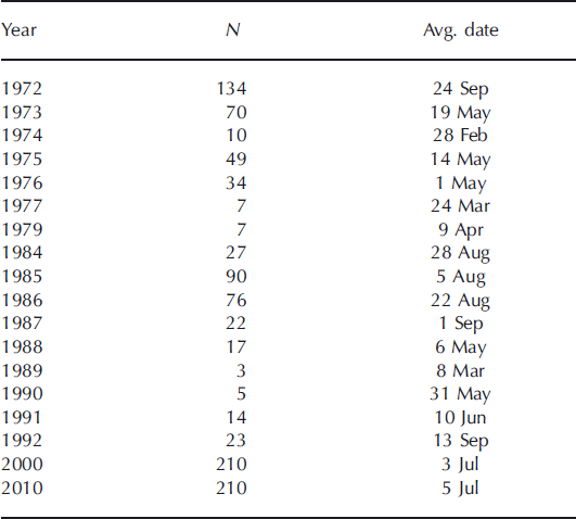
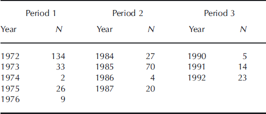
For glaciers with multiple images in each period, we measure front position using the first image acquired. Table 2 presents the number of glaciers imaged for the first time by year within each period. For the period 1972–76, the first image, and thus front position measurement, was acquired for most glaciers in 1972. We therefore nominally assign the year 1972 to this period. Similarly, we assign the years 1985, 1992, 2000 and 2010 to the other periods.
Table 2. The number of glaciers with a first measurement for each year in each of the 1970s, 1980s and 1990s collection periods
To assess the amount of short-term variability within these periods relative to multi-decadal changes, we measured the range in front position for glaciers with images from multiple years within the 1972–76 and 1984–87 periods. The period 1990–92 had too few glaciers with multiple measurements for this analysis. The average maximum deviation in front position for the 132 glaciers with multiple observations between 1972 and 1976 was <85 m. For the 86 glaciers with multiple observations between 1984 and 1987, the maximum deviation in front position averaged 220 m. Over decadal timescales, therefore, we expect the average variations due to short-timescale variability to be comparable to the measurement error discussed in section 2.2.
Based on numerous previous studies (Reference DwyerDwyer, 1995; Reference Sohn, Jezek and van der VeenSohn and others, 1998; Reference JoughinJoughin and others, 2008a,Reference Joughin, Das, King, Smith, Howat and Moonb, Reference Joughin2009; Reference Howat, Box, Ahn, Herrington and McFaddenHowat and others, 2010), we expect seasonal variability in front position of hundreds of meters, ranging up to several km for some glaciers with seasonal floating tongues such as Jakobshavn Isbræ. To minimize the impact of seasonal variability on our results, where multiple images exist in a given year, we select images for mapping that are closest in time of year. Since nearly every orbit repeat is available for 2000 and 2010 ETM+ data, we are able to obtain images within 32 days of each other for measurements involving these years. Further, the majority of Landsat 1–5 images used in this analysis were acquired in the same season (late summer) (Fig. 3), so that seasonal signals in those measurements should be small. In order to test for the influence of seasonality on measured front position changes, we calculated the correlation coefficient between front change and the time-of-year separation between image pairs for each measurement. In no case, however, was a statistically significant correlation found. We therefore expect that the seasonal contribution to the longterm changes examined here should be comparable to, or smaller than, measurement error and short-term changes within measurement periods.

Fig. 3. Box plots of front-position change rate for the sample of 110 glaciers with measurements in each of the 1972, 1985, 2000 and 2010 observation periods. The edges of the boxes denote the 25% (Q 1) and 75% (Q 3) percentiles and the vertical line is the median. The whiskers span the range of data points within the range 3Q 1–2Q 3 to 3Q 3–2Q 1. Data points outside this range are considered outliers and are plotted as crosses and labeled with the glacier name.
3. Results
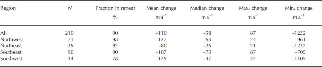
On average, the 210 glacier fronts measured in 2000 and 2010 retreated at a rate of 110 m a−1 and a median rate of 59 m a−1, over the 10 year period, with 191 (91 % of) glaciers in retreat (Table 3). Zachariæ Isstrøm in the northeast, Jakobshavn Isbræ in the southwest and Alison Gletscher in the northwest retreated at rates of >1 km a−1.Two glaciers in the southeast, Midgårdgletscher and Kangerdluluk, and a glacier in the northwest, Upernavik North, all retreated at rates of >0.5 km a−1. The northwest coast had the highest fraction of retreating glaciers (98%) and the fastest mean retreat rate, which was 50 m a−1 faster than in the northeast, which had the slowest rate of retreat.
Table 3. Greenland glacier front-position change rate statistics for the period 2000–10 by region
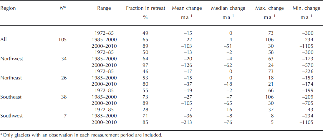
There are 105 glaciers with coverage during the measurement periods 1972, 1984, 2000 and 2010. These glaciers have approximately the same regional distribution and change statistics for the 2000–10 period as the complete 210-glacier sample (Table 4; Fig. 3), with 89% of them retreating at a mean rate of 102 m a−1.On average, there was a much smaller change in glacier front position between 1972 and 1985, with both mean and median rates of retreat within the uncertainty, and nearly equal numbers of retreating and advancing glaciers. Between 1985 and 2000 the fraction of retreating glaciers and mean and median retreat rates rose modestly, primarily due to the onset of retreat at Jakobshavn Isbræ in the southwest and widespread retreat in the southeast. The fraction of retreating glaciers and mean and median retreat rates then rose dramatically in all regions between 2000 and 2010 (Fig. 3), with the mean ice-sheet-wide rate of retreat increasing by nearly a factor of 7 above the 1972–85 rate.
Table 4. Greenland glacier front-position change rate statistics for each survey period by region
Additional information about the timing of accelerated retreat can be obtained by examining the 24 glaciers with observations from all five measurement periods (1972, 1984, 1992, 2000 and 2010). These glaciers are all located on the west coast. The retreat rate statistics for this subsample are similar to those for the complete sample for the 1972–85 and 2000–10 periods, with the fractions of retreating glaciers within 4% of each other and the mean and median rates of retreat within 16 m a−1, suggesting that the sample is indicative of general patterns (Table 5). The fraction of retreating glaciers dropped from 50% between 1972 and 1985 to 16% between 1985 and 1992, suggesting a general advance. The fastest individual glacier advance rates observed occurred during the 1985–2002 period, with both Jakobshavn Isbræ and Sur Glacier (Iterdiagssup Quingua) in the far northwest advancing at >100 m a−1.Harald Moltke Bræ, also in the northwest, had the fastest rate of retreat during this period, likely in response to an earlier surge (Reference Higgins and WeidickHiggins and Weidick, 1990). Nearly all (95%) of the glaciers in the sample then retreated between 1992 and 2000 at mean and median rates approximately two-thirds of the 2000–10 rates.
Table 5. Front-position change rate statistics for the 24 glaciers with measurements in all five survey periods

Reference WarrenWarren (1991) measured changes in front position for 23 West Greenland marine-terminating glaciers, ranging in latitude from the southern tip to Rink Isbræ at 71°44′, between the mid-20th century (mostly 1953) and 1985 using maps and aerial photography. On average, these glaciers advanced 10 m a−1 over this period and only 26% of them retreated (Table 6). The fraction of glaciers retreating increased to slightly over half between 1985 and 2000, with an average rate similar to the larger, ice-sheet-wide sample in Table 3. These glaciers then underwent rapid retreat after 2000. While these measurements are restricted to West Greenland, and therefore may not be indicative of changes around the ice sheet, the retreat rate statistics for 1985–2000 and 2000–10 are similar to the complete dataset, with the fractions of retreating glaciers within 8% of each other and the mean and median rates of retreat within 17 m a−1. This suggests that this subsample is generally representative of ice-sheet-wide changes.
Table 6. Front-position change rate statistics for the 23 West Greenland glaciers measured by both Warren and others (1991) and this study

4. Discussion
The past decade of retreat of Greenland’s marine-terminating glaciers is unprecedented in extent for at least the past half-century. Rapid retreat is ubiquitous; the vast majority of glaciers in all regions, and nearly all glaciers in the northwest, of the ice sheet are retreating at median rates of tens of m a−1 and average rates near or exceeding 100 m a−1. In the southeast, the mean and median retreat rates for 2000–10 are 50–75% of those observed by Reference Moon and JoughinMoon and Joughin (2008) for the period 2000–05, consistent with a recent partial stabilization. All other regions have accelerated or sustained their 2000–05 rates.
The Landsat data show transitions from general stability between 1972 and 1985 to moderate retreat in the southeast and west between 1985 and 2000, and then accelerated retreat in all regions from 2000 to 2010. The subsample of glaciers in Table 3 narrows the timing for the onset of general retreat to the period 1992–2000, reversing a mean advance between 1985 and 1992. The timing of this switch from stability and advance to retreat is coincident with the minimum and reversal of a multi-decadal cooling trend (Reference Box, Yang, Bromwich and BaiBox and others, 2009), and the onset of rapid warming through the present. This suggests, as previously hypothesized (Reference Moon and JoughinMoon and Joughin, 2008), that average changes in glacier front position closely track surface air temperatures on subdecadal, and possibly annual, timescales. Retreat of marine-terminating glaciers over this period has also been attributed to changes in ocean circulation (Reference Holland, Thomas, de Young, Ribergaard and LyberthHolland and others, 2008). It is also possible that variations in surface air temperature and ocean circulation are related, particularly on decadal timescales, through large-scale atmospheric interactions.
We extend our perspective backwards in time by combining our Landsat-derived results with earlier published data. Our comparison with the sample of West Greenland glaciers from Reference WarrenWarren (1991) reinforces the evidence for general stability lasting from ∼1950 until at least the mid-1980s, with rapid changes thereafter. This period falls within a time of substantial cooling, following a rapid warming, comparable to the recent trend, beginning at the end of the 19th century and peaking in ∼1930 (Reference Box, Yang, Bromwich and BaiBox and others, 2009).
Fluctuations in front position for several glaciers since the mid-19th and early 20th centuries are compiled by Reference Weidick, Williams and FerrignoWeidick (1995). Jakobshavn Isbræ has the most complete record, with observations in seven different years between 1851 and 1972. This glacier retreated steadily until the mid-1950s, at an average rate of ∼300 m a−1.The fastest observed retreat, averaging 500 m a−1, occurred between 1929 and 1942. The front then remained almost unchanged until the end of the century. A similar pattern of early 20th-century retreat, followed by mid-century stabilization, is apparent in many other glaciers around Greenland, including extensive loss of potentially floating ice tongues along the northwest coast (Reference Weidick, Williams and FerrignoWeidick, 1995). Many glaciers, however, that have undergone rapid retreat in the past decade showed little or no change in the early 20th century, including the glaciers in the vicinity of Jakobshavn Isbræ along the central west coast and those along the central east coast north of the Geicke Plateau (Reference Weidick, Williams and FerrignoWeidick, 1995). Reference Box and HerringtonBox and Herrington (2007) compiled observations of front positions for 54 glaciers for various years between 1850 and 1990. Although the spatial and temporal heterogeneity of their sample makes comparisons inconclusive, the fraction of retreating glaciers in their time series never exceeded 50%. When compared with the 90% rate for the ice sheet for the past decade, and the fact that >80% of glaciers are retreating in each quadrant of the ice sheet, this suggests that the past decade of retreat may be exceptional in extent since the Little Ice Age.
More certain is that the early 20th-century period of warming and retreat was followed by stabilization, without evidence of a substantial advance until the end of the cooling period in the 1980s. This mid-century period of general cooling lasts for ∼50 years, with the current warming trend beginning in 1994 (Reference Box, Yang, Bromwich and BaiBox and others, 2009). The onset of retreat appears, within the temporal resolution of our measurements, coincident with the onset of warming temperatures, indicating an immediate response. This behavior suggests an asymmetric response of glacier fronts to warming and cooling, with warming leading to sudden, widespread retreat and cooling leading to a slower, lagging advance. This asymmetry is consistent with the tidewater glacier cycle, as proposed by Reference Meier and PostMeier and Post (1987), in which the rate of advance is limited by the rate at which the glacier can deposit a till shoal, upon which it overrides. Retreat, on the other hand, can be accelerated by dynamical feedbacks as the glacier thins and un-grounds (Reference PfefferPfeffer, 2007; Reference Howat, Joughin, Fahnestock, Smith and ScambosHowat and others, 2008; Reference JoughinJoughin and others, 2008a). While it is uncertain if Greenland glaciers advance upon till shoals, the growth of floating ice tongues would have a similar effect by providing back-stress to the grounded ice inland, resulting in thickening and further advance (Reference Howat, Joughin and ScambosHowat and others, 2007). In either case, the rate of advance is limited by the flux of ice from up-glacier and therefore likely to be slower than retreat.
It is worth repeating that our analysis only applies to the averaged behavior of many glaciers, and that changes in front position at any single glacier will be influenced by a number of local factors, such as ice dynamics, bed geometry and fjord conditions, independent of climate forcing. Numerous examples of this independent behavior can be found in all time periods and in all regions (Reference WarrenWarren, 1991; Reference Warren and GlasserWarren and Glasser, 1992; Reference Weidick, Williams and FerrignoWeidick, 1995; Reference Joughin, Smith, Howat, Scambos and MoonJoughin and others, 2010). This historical variability in behavior makes the relatively uniform retreat of the past decade that much more remarkable, with the implication that regional climate forcing is, in aggregate, overwhelming local controls on front position.
5. Conclusions
The past decade of retreat is the most widespread in the past half-century and possibly since the Little Ice Age. On average, glaciers are retreating quickly in all sectors of the ice sheet. The onset of the current retreat followed a general advance between 1985 and 1992, which occurred at the end of a 60 year cooling period. The slow and relatively limited advance during a period of mid-century cooling suggests a lag of several decades between declining temperatures and marine terminus advance. In contrast, warming and the onset of retreat between 1992 and 2000 appear synchronous. This suggests an asymmetric response of marine-terminating fronts to variations in external forcing, which is consistent with the contrasting mechanisms controlling advance and retreat.
If the limit of glacier retreat is largely controlled bed topography, as suggested by theory (Reference SchoofSchoof, 2007), and numerical models (Reference Nick, Vieli, Howat and JoughinNick and others, 2009), we may expect the rate of retreat to diminish in the near future, even under continued warming, as glaciers reach the inland end of basal overdeepenings and/or rise above sea level (Reference Joughin, Smith, Howat, Scambos and MoonJoughin and others, 2010). This limit may already be apparent in the slight slowing of southeastern glacier retreat from the peak estimates of Reference Howat, Joughin, Fahnestock, Smith and ScambosHowat and others (2008) and Reference Moon and JoughinMoon and Joughin (2008). Large regions of the northeast and north coasts, however, have beds extending below sea level far inland. Alternatively, an end to the current warming trend, potentially from a shift in large-scale atmosphere and ocean circulation, could result in stabilization (Reference Moon and JoughinMoon and Joughin, 2008; Reference Box, Yang, Bromwich and BaiBox and others, 2009). Based on the historical record and the apparent asymmetry in the response to climate warming and cooling, as discussed above, substantial advance and ice-sheet expansion would take many decades of cooling.
Acknowledgements
This work was funded by grants NNX08AQ83G and NNX08AL98A from NASA and by The Ohio State University’s Climate, Water, Carbon Program. Suggestions from J. Box, associate editor J. Woodward and two anonymous reviewers substantially improved the manuscript.


