


1. Introduction
Dry-slab avalanches cause extensive property damage and fatalities each year throughout the world. The majority of these avalanches slide on a weak layer that was formed at or near the snow surface and was subsequently buried (Reference BirkelandBirke-land, 1998; Reference Schweizer and LütschgSchweizer and Lütschg, 2001). Near-surface facets (a layer that forms at or near the snow surface due to temperature gradients) accounted for 59% of avalanches in a case study in southwest Montana, USA (Reference BirkelandBirkeland, 1998). When buried by additional snowfall, surface hoar is particularly dangerous: ∼30% of skier-triggered avalanches have been associated with surface hoar (Reference BirkelandBirkeland, 1998; Reference Schweizer and LütschgSchweizer and Lütschg, 2001). Understanding the conditions surrounding the formation of these crystals has been the topic of numerous research projects.
Surface hoar has been studied for decades (Reference SeligmanSeligman, 1936). Reference GowGow (1965) observed ‘spike-like crystals’ now referred to as surface hoar that formed during periods of still weather and clear skies. Reference Lang, Leo and BrownLang and others (1984) proclaimed that their research was the first ‘thorough quantitative study of surface hoar’ and that formation was associated with significant temperature differences between the snow surface and air. Reference ColbeckColbeck (1988) calculated the importance of temperature profiles and humidity to form surface hoar and concluded that ‘some wind’ is necessary for surface hoar growth, which was confirmed by Reference Hachikubo and AkitayaHachikubo and Akitaya (1997).
Although previous research exists (Reference LaChapelle, Gold and WilliamsLaChapelle, 1970; Reference LaChapelle and ArmstrongLaChapelle and Armstrong, 1977; Reference ArmstrongArmstrong, 1985; Reference Akitaya and ShimizuAkitaya and Shimizu, 1987), Reference ColbeckColbeck (1989) conducted one of the first studies of near-surface facet by examining various scenarios that explain the existence of crystal growth just beneath the surface. In a case study by Reference Fukuzawa and AkitayaFukuzawa and Akitaya (1993) the snow surface metamorphosed into faceted grains over two nights of clear skies. Reference FierzFierz (1998) reported that new low-density snow that accumulated on a denser pack and was followed by clear weather resulted in a crust on the surface with 1.5–2 mm facets underneath. The establishment of near-surface faceted crystals as an area of expanded study is partially credited to work conducted by Reference BirkelandBirkeland (1998) and Reference Birkeland, Johnson and SchmidtBirkeland and others (1997, Reference Birkeland, Johnson and Schmidt1998), in which the term ‘near-surface facets’ was coined to describe ‘snow formed by near-surface vapor pressure gradients resulting from temperature gradients near the snow surface.’ Reference Cooperstein, Birkeland, Hansen and ElderCooperstein and others (2004) reported that faceted crystals were better developed on south-facing slopes compared to a north-facing aspect at similar elevations. In the most complete quantitative investigation of near-surface faceting to date, Reference Morstad, Adams and McKittrickMorstad and others (2007) successfully grew radiation-recrystallized near-surface facets in a laboratory. Similarly, Reference Slaughter, Adams, Schweizer and van HerwijnenSlaughter and others (2009) successfully simulated observed near-surface facet events from the field in the laboratory and demonstrated that despite the inherent difference between the laboratory and nature, facets grew under similar conditions in both scenarios.
These references are only a portion of the body of literature that examines the conditions surrounding surface hoar and near-surface facet formation (e.g. Reference SlaughterSlaughter, 2010; Reference Stössel, Guala, Fierz, Manes and LehningStössel and others, 2010); however, only limited research exists that quantifies specific environmental conditions that surround their formation. To this end, weather stations were established in union with daily observations and crystal-scale photographs of the snow surface. The following summarizes the results obtained from this field investigation, which is only a single constituent of an ongoing collaborative effort between researchers at Montana State University and the Yellowstone Club (YC) Ski Patrol. The specific goals of this paper are (1) to present the recorded field observations of surface hoar and near-surface facet formation (mainly due to radiation recrystallization) and (2) to propose statistical methods that serve as the first step to utilizing this data for further quantification of the conditions necessary to yield surface hoar and near-surface facet formation.
2. Methods
Two study areas were selected, one on a north- and one on a south-facing slope located on Pioneer Mountain at the YC near Big Sky, Montana. The south (2757 m; aspect 187°) and north (2532 m; aspect 0°) areas both have a slope angle of ∼30° and have been used in previous research studies (Reference Cooperstein, Birkeland, Hansen and ElderCooperstein and others, 2004; Reference Staples, Adams, Slaughter, McKittrick and GleesonStaples and others, 2006; Reference Adams, Schweizer and van HerwijnenAdams and others, 2009; Reference Slaughter, Adams, Schweizer and van HerwijnenSlaughter and Adams, 2009; Reference Slaughter, Adams, Schweizer and van HerwijnenSlaughter and others, 2009; Reference SlaughterSlaughter, 2010). A detailed description of the weather stations is presented by Reference SlaughterSlaughter (2010).
The north and south sites are similarly instrumented to measure air temperature and humidity (Campbell Scientific, Inc. CS215 with 41303-5 naturally aspirated radiation >shield), snow depth (NovaLynx Corp.), snow surface temperature (Everest Interscience, Inc. 4000.4ZL), incoming longwave radiation (Eppley Lab., Inc. PIR and Kipp & Zonen CGR3), slope-parallel incoming and reflected shortwave radiation (LI-COR, Inc. Li200 and Kipp & Zonen CMP3), wind speed and direction (Met One Instruments, Inc. 034B-L) and subsurface snow temperature taken at 2 cm intervals (Omega Eng., Inc. type T thermocouples). Slope-parallel radiation measurements were used to capture the amount of radiation impacting the snow surface including reflected radiation from the surroundings; a third station was located at the top of the American Spirit (Aspirit) lift. This station provided an unobstructed measure of incoming short- and longwave radiation (Eppley Lab., Inc. PSP and PIR). Data were recorded using Campbell Scientific, Inc. CR10(x) data loggers.
Daytime longwave radiation data from the 2007/08 season at the south location were unreliable due to solar contamination associated with the instruments used, the Eppley Lab, Inc. PIR (Reference Albrecht and CoxAlbrecht and Cox, 1977). Generally, this problem is not a concern (Campbell Scientific, 2007). However, in certain applications of intense shortwave radiation (the situation at the south location) an additional correction is required that was not performed during the 2007/08 season. This problem was corrected in subsequent seasons by upgrading to Kipp & Zonen CGR3 instruments that account for this problem.
A correction was defined for the 2007/08 season by comparing the mean daily values of longwave radiation, LW, at the south location with the mean daily values from the Aspirit location, LW a. For the 2007/08 season the ratio of LW to LW a was 1.57, and for the combined data from the 2008/09 and 2009/10 seasons this ratio was 1.07. Assuming that the ratio of 1.07 applies to the 2007/08 season, a multiplier of 0.68 (1.07/1.57) results, which was applied to the LW values reported for the 2007/08 season.
Each season, the YC Ski Patrol maintained daily visual and written observations in addition to grain-scale images detailing the upper 5 cm of the snowpack. Snow crystal images were captured using a Panasonic PV-500, Olympus SP-510 UZ or a Nikon Coolpix fitted with a 10 × loupe from a Brunel 8 × 30 ocular. The same Brunel scope was utilized for the crystal classification. The daily records and images were cataloged with custom software designed for use in this project (Reference SlaughterSlaughter, 2010).
3. Results
3.1. Surface hoar
During the 2007/08 (A), 2008/09 (B) and 2009/10 (C) winter seasons, 35 significant events of surface hoar were recorded. These events occurred at both the south and north weather stations, but not always at both. A significant event is defined by two criteria: (1) the field notes identify the crystals as surface hoar and (2) the images corroborate the field note statements. Table 1 gives the mean values of the measured weather data: longwave radiation, LW; air and snow temperature, T a and T s; wind speed, V w; wind direction, Dir; relative humidity, RH, and incoming long-wave radiation at Aspirit station, LWa , for each event at the station(s) where crystals were observed. The means were computed using the data from the night prior to event date shown, from dusk to dawn (nightly). The mean was selected as the most intuitive single parameter for exploring the data, given that this paper presents only a first step in analyzing the data.
Table 1. Summary of mean nightly weather conditions for the surface hoar events, including longwave radiation (LW; W m−2), air (T a; °C) and snow surface (T s; °C) temperature, wind speed (V w; m s−1)and direction (Dir; °), relative humidity (RH; %), and the difference between the air and snow temperatures (ΔT; °C). Blank regions indicate that no surface hoar was found at that location. Incoming longwave at Aspirit is denoted as LW a and – indicates missing data

In addition to the above parameters, the interaction between the air and snow surface temperature was also computed, as ΔT = T a – T s. This value is typically reported in the literature discussing surface hoar. The interactions between all of the parameters should be the topic of future research; such interactions were explored numerically by Reference SlaughterSlaughter (2010).
In some instances the incoming longwave radiation, LW, differs significantly between the north and south stations (e.g. A-1). The reason for the discrepancy is difficult to ascertain, the most likely being the influence of solar heating on the rock face above the south station that then radiates at night (Reference Staples, Adams, Slaughter, McKittrick and GleesonStaples and others, 2006). Hence, the unobstructed Aspirit measurements of incoming longwave radiation are included in Table 1 to examine if this measurement may be an indicator of surface hoar formation.
In all but a few events, complete weather data and grain-scale images of the crystals exist. Summarizing each of the 35 events is impractical, but to illustrate the information that may be ascertained, an example event from each season follows.
3.1.1. Event A-6: 26 February 2008
Large surface hoar formed at both the north (4–8 mm) and south (2–4 mm) locations the night between 25 and 26 February 2008. According to the field notes, the crystals developed on 2–3 mm ‘broken stellars’ at the north location and on 2 mm ‘rimmed new snow’ at the south. Figure 1 shows images of both the underlying crystals and the surface hoar crystals that developed at the north location. The surface hoar persisted at the north location through the following few days. No records of the surface hoar persisting at the south location were recorded.

Fig. 1. Images (1 mm grid) from event A-5 showing (a) the underlying snow crystals and (b) the surface hoar crystals that developed on the surface.
3.1.2. Events B-7 and B-8: 13 and 14 February 2009
Surface hoar was reported at the north site on two consecutive days: 13 and 14 February 2009. According to field notes on 13 February, the surface hoar was ‘[half] surface hoar and [half] decomposing stellars’ 1 mm in size. The following day, 14 February, the surface hoar was more pronounced and reported as 1.5 mm in size, but was decomposing at the time of the observations. Images from the north on both days are shown in Figure 2.

Fig. 2. Images from events B-7 and B-8 showing surface hoar that formed at the north location on (a) 13 February and (b) 14 February 2009.
Interestingly, at the south location the formation of near-surface facets due to radiation recrystallization was reported. At 1313 h on 13 February the field notes indicated near-surface facets in the top 2 cm of the snow, as shown in Figure 3. On the following day, 14 February, the field notes stated: ‘Facets [are present] in the surface snow. Some look larger than yesterday, but not as many striations are noted. [The crystals do not] seem to be standard [radiationrecrystallization facets]. Perhaps there was some small amount of decomposition and regrowth overnight.’

Fig. 3. Images showing the faceted crystals that formed at the south location on (a) 13 February (event B-7) and (b) 14 February (event B-8) 2009.
Generally, the weather conditions at the north and south locations were similar; for example, Figure 4a compares the incoming longwave radiation. Snow surface temperature, as shown in Figure 4b, demonstrates one of the only obvious differences observed between the locations. During the daytime the south location warmed ∼15°C on 13 February, while the north had minimal temperature fluctuations. The formation of near-surface facets as well as the coincidental formation of near-surface facets and surface hoar is discussed further in section 5.

Fig. 4. Weather data from events B-7 and B-8 comparing the (a) incoming longwave radiation and (b) snow surface temperature between the north and south locations, 12–14 February 2009.
3.1.3. Event C-5: 12 January 2010
A significant and persistent surface hoar layer developed between 11 and 12 January 2010 at the north location. The field notes state ‘two layers of surface hoar [were] stacked on top of each other.’ At the surface, 4–8 mm crystals were observed and, just below the surface, 2–4 mm surface hoar crystals were present with decomposing new snow underneath both layers (see Fig. 5). The lower layer of surface hoar likely formed the night prior to the event. Surface hoar was observed at the south location on 11 January (C-4), but no observations at the north station were conducted. On 12 January the south station experienced significant melting and no surface hoar was present.

Fig. 5. Images from event C-5 showing the (a) underlying snow crystals and (b) surface hoar crystals that developed on the surface.
The persistence of this layer of surface hoar is notable. The field notes indicate its presence for 15 days: on 13 January ‘7 cm down, the 1 cm of surface hoar is still persistent’; on 21 January ‘surface hoar is buried under 13 cm of snow’; and on 27 January ‘surface hoar is still buried approximately 30 cm under [the] surface’. There is no further mention of this layer after 27 January.
3.2. Near-surface facets
During the three seasons of observations, near-surface facets were recorded on 47 days. These events occurred exclusively at the south weather station. An event was defined using the same criteria as for surface hoar (section 3.1). Table 2 includes the daytime mean values of the measured weather data. To distinguish between the surface hoar and near-surface facet events, the latter are denoted using double letters (e.g. AA-1 refers to the first near-surface facet event in the 2007/08 season). The means were computed using data from the event date shown, from dawn to dusk (daytime).
Table 2. Summary of mean daytime weather conditions for days with near-surface facet events for each of the three seasons: slope-parallel shortwave (SW) and longwave (LW) radiation; air (T a) and snow surface (T s) temperature; wind speed, V w, and direction, Dir, and relative humidity, RH. Superscript ‘a’ denotes the Aspirit station, – indicates missing data and, as detailed in section 2, a correction was applied to the 2007/08 longwave data

In addition to the individual parameters, the ratio between long- and shortwave radiation was considered. This value was indicated to be of critical importance by Reference SlaughterSlaughter (2010) and Slaughter and Adams (in press). As with the case of surface hoar, the interactions between all of the parameters should be the topic of future research. Additionally, the Aspirit data were included in the analysis to assess if the unobstructed radiation measurements were an indicator of near-surface facet formation.
3.2.1. Event AA-2: 14 February 2008
Event AA-2 was a widespread near-surface facet event and has been the subject of additional analysis (Reference Slaughter, Adams, Schweizer and van HerwijnenSlaughter and others, 2009). Initial observations that occurred at 1100 h at the south station reported minimal amounts of surface hoar, as shown in Figure 6a. A second observation at 1400 h indicated that additional ‘needle-like’ growth had occurred, as shown in Figure 6b.

Fig. 6. Images of near-surface facet event AA-2 on 14 February 2008. (a) The initial observation at 1100 h and (b) a second observation at 1400 h.
The formation of these crystals occurred with air temperatures that rose between 0600 h and 1400 h from −17°C to −4°C and snow surface temperatures that increased from −25°C to −4°C. The facets formed in new snow that had fallen the previous day; the density was reported as 20 kg m−3. This warming was more pronounced in the subsurface. It was reported that the snow between 1 and 5 cm deep was moist. Thus, the temperature gradient in the upper centimeter of snow was ∼400°C m−1.The facets persisted, being buried on 16 February by 4–5 cm of new snow, as recorded in the field notes: ‘facets are still visible on the upper crust interface.’
3.2.2. Events BB-3 and BB-4: 12 and 13 February 2009
On 12 February 2009, observations showed that new snow became faceted in a matter of hours. The initial observation at 1015 h reported 1–2 mm of new snow (Fig. 7a). At 1245 h, facets measuring 1 mm were observed (Fig. 7b) at the snow surface with a moist layer between 2 and 5 cm. Facets at the surface were observed for the following two days (Fig. 7c and d). As mentioned in section 3.1, this event occurred during the day after a surface hoar event at the north location. This relationship is discussed further in section 5.

Fig. 7. Images of a near-surface facet event that (a, b) occurred at the south location on 12 February 2009, (c) continued on 13 February and (d) was also observed on 14 February.
The field notes on 14 February state ‘[the facets] look larger than yesterday, but not as many striations are noted [and they] don’t seem to be standard [radiation-recrystallized near-surface facets].’ Hence, it is unknown if the facets observed on the days following the initial event formed during the day, night, both, or simply persisted. Thus, the days following the 13 February event were not included as an event. However, these faceted crystals persisted, being buried by 9 cm of new snow the night of 14 February (Fig. 8).

Fig. 8. Images of a near-surface facet event that occurred at the South location and persisted beneath 9 cm of new snow falling on the night of February 14, 2009.
3.2.3. Event CC-12: 27 March 2010
An interesting near-surface event occurred on 27 March 2010. On 26 March, 20 cm of new snow was recorded and a trace of new snow was recorded on the night between 26 and 27 March. At 1245 h on 27 March, near-surface facets were observed that, as shown in Figure 9, grew as columns perpendicular to the plane of the new snow crystals. Crystals behaving in a similar fashion were observed in many of the events during all three winter seasons. Given the snow temperature on 27 March, this behavior is expected. It was near −5°C, precisely in the columnar, c-axis growth region on the snow crystal morphology diagram (Reference NakayaNakaya, 1954).

Fig. 9. Images of a near-surface facet event that occurred at the south location on 27 March 2010.
4. Analysis
4.1. Surface hoar
The general weather conditions were compared to the event-specific conditions to determine which environmental parameters may be statistically related to the formation of surface hoar. First, the data from both stations and all three seasons were combined into a single dataset. This was done primarily because only a small number of surface hoar events occurred for any one season/station. From these combined data, the mean nightly averages for each event in Table 1 (‘event-only days’) were compared to the nightly averages from the complete dataset (‘all days’).
This comparison (event-only days with all days) was accomplished using a Kolmogorov–Smirnov goodness-of-fit test (KS-test; Reference MasseyMassey, 1951). The test provides a means to determine whether the two datasets are from the same distribution. The results of these comparisons are provided in Table 3, where the null hypothesis (H0) was that the two datasets were from the same distribution at the 0.05 significance level. The hypothesis states that P-values <0.05 would result in a failure to reject the null hypothesis, meaning that the distributions were likely different.
Table 3. Kolmogorov–Smirnov test results for each weather variable measured, comparing the complete dataset (all days) with the event-only days

The results from the KS-test indicate that incoming longwave radiation (including the Aspirit data), snow surface temperature, wind speed, relative humidity and air/snow temperature difference likely originate from different distributions. Thus, it is assumed that these factors are related to the formation of surface hoar. Visually, each of the parameters may be compared in Figure 10, which shows empirical probability density functions (PDFs) of the complete (all) and event-only datasets. The PDFs were computed using the kernel-density estimation method with an Epanechnikov kernel (Reference ScottScott, 1992; Reference Martinez and MartinezMartinez and Martinez, 2008).

Fig. 10. PDFss comparing all recorded night-time mean weather conditions at both stations (dashed curve) to the days associated with observed surface hoar events (solid curve).
The event-only data deemed significant via the KS-test were used to assign a range of conditions for surface hoar development, which are presented in the form of highest-density regions (HDRs) (Reference HyndmanHyndman, 1996) in Table 4. The HDRs are a means of quantifying the empirical PDFs presented in Figure 10. For example, referring to Table 4, the upper and lower 95% HDR values of longwave radiation are 159 and 306 W m−2, respectively. This range defines the limits such that 95% of the data from this distribution lie between these two values. Graphically, for the purpose of illustrating the definition of HDRs, the 95% HDR is displayed for the longwave PDF in Figure 11. (For comparison, 95%, 68% and 38% HDRs are equivalent to 2, 1 and 0.5 standard deviations about the mean of a normal distribution, respectively.)
Table 4. Limits of highest-density regions (HDRs) of environmental variables coupled to the formation of surface hoar

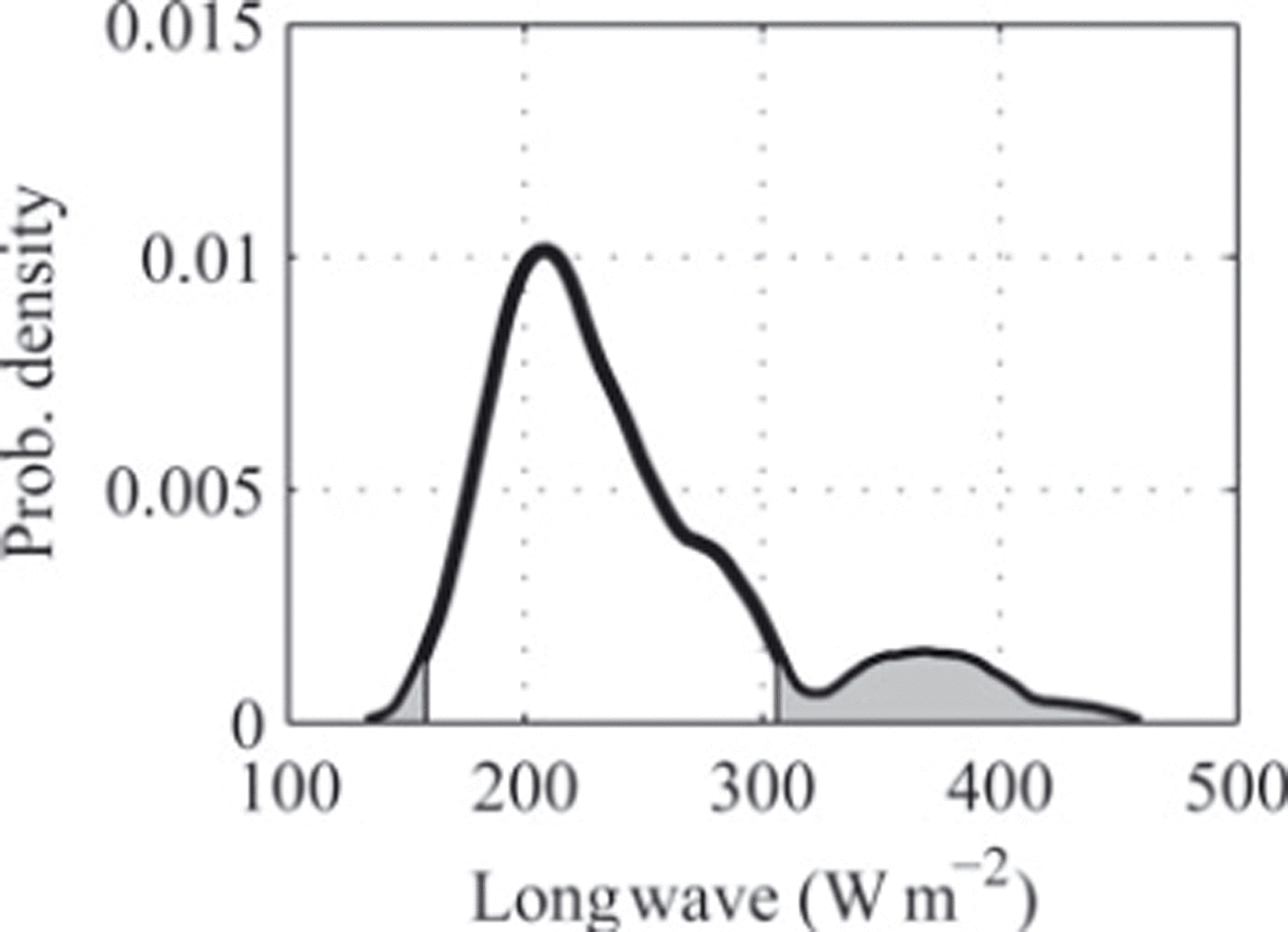
Fig. 11. Example illustrating the definition of the 95% HDR; 5% of the PDF for longwave radiation (see Fig. 10a) lies within the shaded region.
Reference Cooperstein, Birkeland, Hansen and ElderCooperstein and others (2004) detailed two surface hoar events that occurred at the same locations, where minimum snow surface temperatures were reported as −15.1 and −14.2°C for the north site and −11.1 and −12.5°C at the south site. Mean values for the night were not reported, but the minimum values for many of the events reported here were representative of the mean (i.e. the snow surface temperature remained relatively constant through the night), as shown in Figure 4. The values from the north fell within the 25% HDR, and the south temperatures lie within the 75% HDR. These results indicate, if only snow surface temperatures are considered, that surface hoar formation is less probable at the south site than at the north. Reference Cooperstein, Birkeland, Hansen and ElderCooperstein and others (2004) concluded that the surface hoar at the south location was less developed than at the north station, which indicated that the conditions were less favorable for development. Based on the current understanding, ascertaining surface hoar formation from a single parameter is problematic, but this example demonstrates how the data may begin to be applied.
A similar analysis to the above may be performed using two multi-day surface hoar events recorded in Japan (Reference Hachikubo and AkitayaHachikubo and Akitaya, 1997b). The average snow surface temperatures for the five nights reported were one of three temperatures: −12, −14 or −16°C. Referring to Table 4, the −12°C value is within the 75% HDR and the −14 and −16°C values are within the 50% HDR.
Previously published data were generally within the 50% HDRs. Reference Mason, Bryant and van den HeuvelMason and others (1963) and Reference Lang, Leo and BrownLang and others (1984) explain that surface hoar formed between −12 and −16°C. Reference BreyfogleBreyfogle (1987) found formation occurred with a relative humidity of 70%. Reference Hachikubo and AkitayaHachikubo and Akitaya (1997a) state that wind speed above the snow was 1–2 m s−1 during surface hoar formation. ΔT is reported to range from 5 to 10°C (Reference Linkletter and WarburtonLinkletter and Warburton, 1976; Reference Feick, Kronholm and SchweizerFeick and others, 2007).
The analysis presented here is only a first step, since the ranges defined are independent. For example, considering the variance of all other parameters, surface hoar was most likely to occur with incoming longwave radiation of 178–254 W m−2 or a wind speed of 1–1.4 m s−1, etc. The word ‘or’ is important since the interactions between the various parameters are not accounted for in this analysis. Consider an average incoming longwave radiation value of 202 W m−2 (lower 25% HDR); for this value of longwave radiation the ideal snow temperature with respect to surface hoar formation is not necessarily (although it may be) the corresponding 25% HDR value of −15.7°C. The ranges presented here are independent from each other and are presented as the first step to utilizing the YC data. Statistically analyzing the importance of the interactions is not trivial and should be the topic of future research; it is addressed numerically by Reference SlaughterSlaughter (2010).
4.2. Near-surface facets
In similar fashion to section 4.1, the daytime mean averages of all recorded days are compared to the event-specific days. The results of these comparisons are given in Table 5 and indicate that six parameters may be statistically linked (rejection of H0) to the formation of near-surface facets, particularly due to radiation recrystallization. Figure 12 shows empirical PDFs demonstrating the differences between the entire dataset and the event-only days for these six terms.
Table 5. Kolmogorov–Smirnov test results comparing the daytime means from all recorded data with those with near-surface facet events; the null hypothesis (H0) was that the data were from the same distribution


Fig. 12. PDFs comparing all recorded daytime mean weather conditions at the south site (dashed curve) to the days associated with observed near-surface facet events (solid curve).
Using HDRs, as in section 4.1, the empirical PDFs of Figure 12 were tabulated into ranges for the daytime mean values of each variable. Table 6 shows the ranges that were statistically linked to the near-surface facet events observed.
Table 6. Limits of highest density regions (HDRs) of environmental variables coupled to the formation of near-surface facets

Reference Morstad, Adams and McKittrickMorstad and others (2007) successfully formed radiation-recrystallized near-surface facets in ten laboratory experiments. The mean shortwave radiation for these experiments was one of three values: 595, 755 or 1180 W m−2. Long-wave radiation ranged from 270 to 320 W m−2 and relative humidity ranged between 15% and 40%. A comparison of the shortwave values with the data in Table 6 indicates that only the experiments conducted with shortwave at 595 or 755 W m−2 were within the range of mean values observed in the field at the south location. The reported relative humidity values were near the limits of the 95% HDR. This mismatch is likely the result of the laboratory experiments being performed under conditions not attainable at the south location, but may indicate an inherent flaw in the analysis.
A computation of the ratio of short- to longwave radiation using the Reference Morstad, Adams and McKittrickMorstad and others (2007) laboratory experiments yielded four values: 2.2, 2.4, 2.7 and 3.9. These values, with the exception of 3.9, fit within the 75% HDR. In another study, observations made at the south station by Reference Cooperstein, Birkeland, Hansen and ElderCooperstein and others (2004) found near-surface facet growth during 587 W m−2 of shortwave radiation, which also falls within the 75% HDR. These comparisons indicate that the data presented in Table 6 may be a reasonable tool for assessing the formation of near-surface facets due to radiation recrystallization. However, making definite statements is difficult, as there are few observations with quantified conditions available for comparison.
As explained above, the interactions between environmental values were generally not considered, with the ratio of short- and longwave radiation being the exception. The interaction of the various parameters is addressed in detail by Reference SlaughterSlaughter (2010). This interaction may be significant, since individually the short- and longwave values reported by Reference Morstad, Adams and McKittrickMorstad and others (2007) did not seem to fit into the ranges observed in the field.
5. Discussion
As discussed, particularly in the B-7 and B-8 events and events BB-3 and BB-4, the formation of surface hoar and near-surface facets are seemingly correlated. Out of the 47 days with recorded near-surface facet events, 20 (43%) were observed during the daytime before or after the formation of surface hoar. This relationship is explored further using a similar approach to the previous section. First, two additional distributions are defined using the daytime period prior to and following the surface hoar events based on the dates given in section 3.1. These distributions are referred to as ‘before’ and ‘after’. They were compared, using the KS-test with a 0.05 significance level, to the daytime distributions associated with near-surface facet events. The resulting P-values for these comparisons are given in Table 7. The null hypothesis (H0) is that the distributions are from the same population. To restate, Table 7 compares the distributions derived from the days with near-surface facet formation presented in section 3.2 with two additional distributions: one from the daytime before and one from the daytime after the formation of surface hoar. This comparison allows the following question to be answered statistically: Are the environmental conditions during the daytime hours surrounding surface hoar events similar to daytime hours associated with near-surface facets?
Table 7. Resulting P-values from KS-tests performed comparing the daytime periods before and after surface hoar events to the days with near-surface facet formation

For all the environmental variables considered, the daytime following a surface hoar event (i.e. ‘After’ in Table 7) is likely from the same distribution as the daytime for the near-surface facet events. For the day prior (i.e. ‘Before’ in Table 7) the same may be stated with two exceptions: the snow surface temperature, T s, and the relative humidity, RH. These results indicate, with respect to the south location studied here, that the environmental conditions during the daytime periods before and after surface hoar events are similar to the conditions necessary for near-surface facet formation. This apparent relationship may be due to errors in crystal classification, but on many occasions when near-surface facets were observed the growth was observed between a morning and afternoon observation. Thus, the relationship of the conditions between these two forms of snow crystals is likely meaningful.
6. Conclusion
Throughout three seasons, 35 surface hoar events were observed at north- and/or south-facing locations. These events were well documented, with weather data and daily observations. Five terms (incoming longwave radiation, snow surface temperature, wind velocity, relative humidity and the air/snow surface temperature difference) were shown to be associated with the formation of surface hoar. Similarly, 47 days with near-surface facet formation were observed, and indicated that three parameters may be linked to the formation of near-surface facets: incident short- and longwave radiation and relative humidity. In a comparison with the daytime environmental conditions surrounding surface hoar formation, these conditions were statistically similar to the conditions of the near-surface facet events. The data presented indicate that the conditions surrounding the formation of near-surface facets and surface hoar are linked, a result that to the authors’ knowledge has not before been shown statistically.
The ranges of conditions presented in this paper for both surface hoar and near-surface facets are presented as a postulate for defining the conditions necessary for growth based on weather data. However, the data here were developed from only two locations on the same mountain and only for three seasons, so increasing the dataset would likely provide a more reliable tool. Additionally, the importance of the interactions between the parameters should be the focus of future analysis before solid conclusions may be defined. Nonetheless, the work presented in this paper is the first step. It is the most extensive field investigation of surface hoar and near-surface facets conducted to date, adding to the existing body of knowledge regarding these crystals, and may assist in developing a tool to determine whether formation is based purely on environmental conditions. The cooperative relationship between Montana State University and the Yellowstone Club is planned to continue; thus this dataset as well as the various applications will continue to grow.
Acknowledgements
We thank the Yellowstone Club for providing access and resources, and the reviewers of the manuscript for helping improve the paper. A portion of the work was conducted at the Montana State University Subzero Science and Engineering Facility, which was developed with the support of US National Science Foundation (NSF) grant No. ANT-0521360 and the M.J. Murdock Charitable Trust. A portion of this work was funded by NSF grant No. EAR-0635977, the NSF Graduate Teaching Fellows in K-12 Education Program and research grants from the 2000 International Snow Science Workshop and the American Avalanche Association.


