


Introduction
The state of Alaska is the largest in surface area but has the smallest population (approximately 400 000 people in 1970) of all the states. Alaska’s 586 400 square miles (1 518 900 km2) contain a land area one—fifth the size of the contiguous United States with over 47 000 miles (75 625 km) of coastline. Alaska is the farthest north and west of all the states. It contains four time zones and spans greater latitude than does the contiguous southern 48 states. The coastline in Alaska exceeds the combined coastlines of all the U.S.A. including Hawaii. The state includes the Aleutian Islands, extending south—westward from the mainland and the Alexander Archipelago, a group of 1 100 islands adjacent to the south—east coast of Alaska. Juneau, the state capital (population 22 000), is located on the mainland adjacent to Alexander Archipelago. The larger centralized population centers are in South—central [Anchorage (population 220000)] and in Interior Alaska [Fairbanks (population 40 000)]. These population centers are connected by the Alaska Railroad and Alaska Highway system, the main surface transportation and utility routes within the state. The Trans—Alaskan Pipeline System (TAPS), a major utility corridor, transects the state from the north at the Arctic Coast to Valdez at the Gulf of Alaska (Fig. 1).
From generally shallow ocean waters on the north and west coasts and deep—water fiords along the southern coasts, the land rises to a maximum of 20 320 ft (6 194 m) at Mount McKinley (Denali). This mountain, the highest point in North America, occurs within the Alaska Range, which extends from the northern Alaska Peninsula to the Yukon (Canada) border. Further to the north is another major mountainous region, the Brooks Range. The Brooks and Alaska Ranges are separated by the drainages of the Yukon—Tanana and Kuskokwim Rivers and by maturely dissected intermontane plateaux consisting primarily of rolling uplands and hills. Except for extensive lowlands adjacent to the Bering Sea and Arctic Ocean (i.e. in the south—western and northern regions), the state is fairly mountainous with large abrupt elevation changes in the South—central and South—east regions north of the Gulf of Alaska (Fig. 2).
Alaska’s great geographic extent, from lat. 54° N. to 71°N. and from long. 130° W. to 172° E., creates a large range of seasonal and regional climatic conditions throughout the state. The southern sector generally has a mild maritime climate but in the interior of the state, annual temperatures vary widely. Mean annual temperatures range from 10°F (—12°C) in northern maritime zones (i.e. the Arctic coast) to 45°F (7°C) in southern maritime coastal zones. Extreme temperatures range from over 100°F (38°C) to below —80°F ( —62°C) in the continental interior. Average summer and winter temperatures in Fairbanks are 59°F (15°C) and —11°F (—24°C) respectively. Annual precipitation in the state varies considerably, being over 300 inches (762 cm) in parts of South—eastern Alaska, 84—130 inches (2 13—330 cm) along the southern flank of the Alaska Range, about 12 inches (30 cm) at Fairbanks in the Interior, and about 4 inches (10 cm) at Point Barrow on the Arctic coast. Snow covers most of Alaska for 6 to 9 months of the year, except in some low elevation areas immediately adjacent to coastal waters of South—central and South—eastern Alaska (Fig. 3). Elevations above 1 0 000 ft (3 000 m) are commonly covered with snow all year.
Heavy annual precipitation and sub—freezing air temperatures in the coastal mountains of the South—eastern and South—central regions of Alaska favor permanent snow—fields, glaciers, and ice fields. Perennial ice and snow covers 28 100 square miles (72 780 km2) of the state (Reference Zenone and AndersonZenone and Anderson, 1978). Over 30% of the state has mountainous terrain that is subject to snow—avalanche activity. Historically, widespread snow—avalanche activity has caused no major concern mainly because of the large land mass, low population density, and lack of development. With increases in population, in development, and in use of the mountainous areas, an awareness of potential hazards and dangers is rapidly developing within the state.
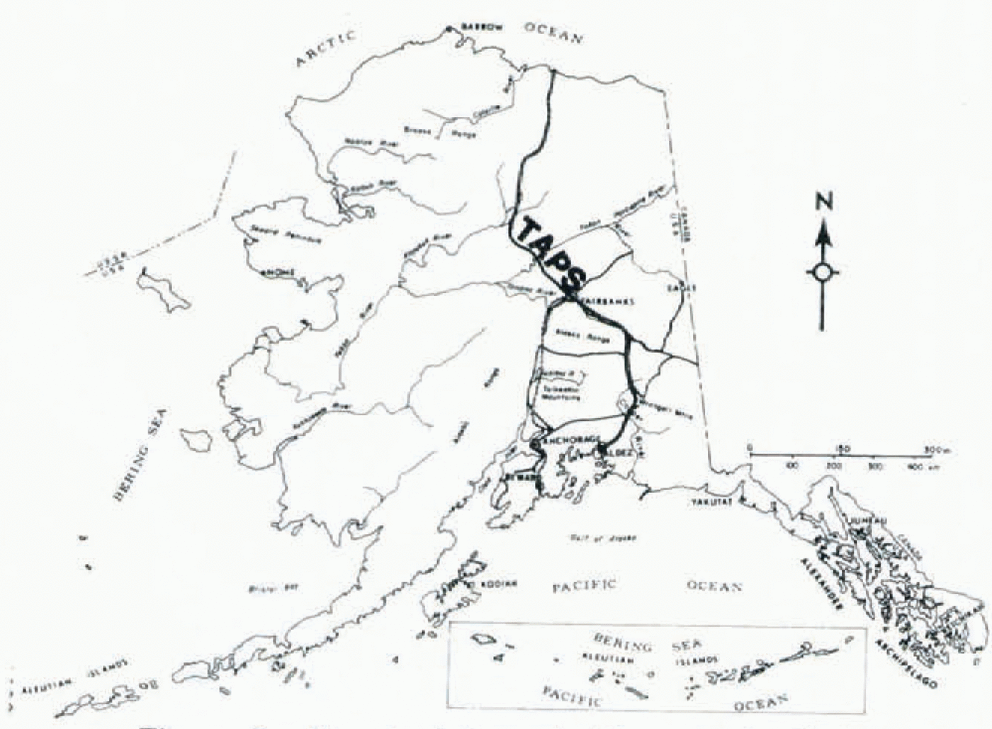
Fig. 1. Land transportation and utility routes in Alaska.
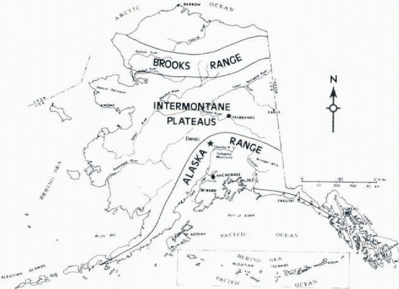
Fig. 2. Major mountainous regions in Alaska.
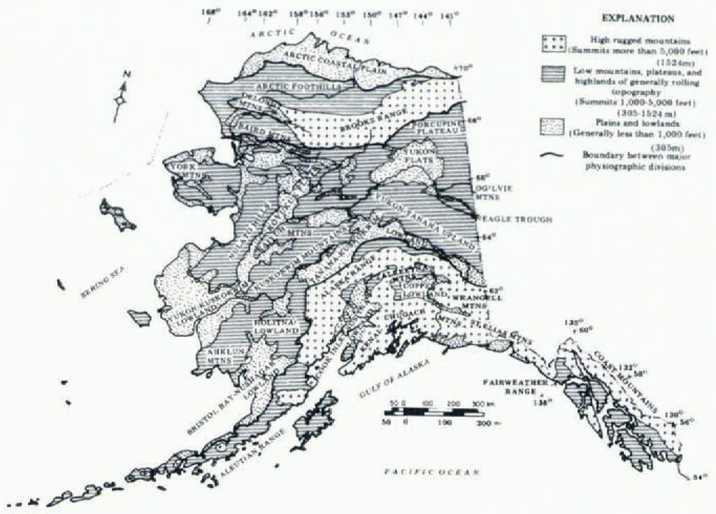
Fig. 3. Physiographic provinces of Alaska (adapted from Reference WahrhaftigWahrhaftig, 1965).
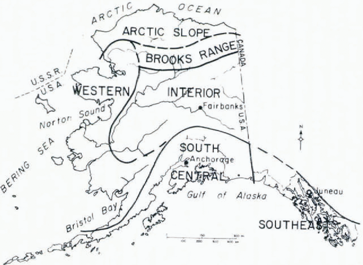
Fig. 4. Snow—avalanche regions in Alaska.
Snow—Avalanche Regions in Alaska
Because of the need for state-wide geologic hazard awareness and information, the State of Alaska Division of Geological and Geophysical Surveys (Alaska DGGS) has started a preliminary study of geologic hazards in Alaska. The Alaska DGGS is identifying areas within the state that are subject to various hazardous geological and geophysical processes and making such information available to the general public and governmental agencies. As a portion of this study, a section on regional snow—avalanche potential is being prepared. Following completion of the state—wide compilation, more detailed maps and reports on specific geologic hazard areas, including snow avalanches (maps are in preparation by S. W. Hackett and G. Davidson) are planned to follow. This paper generally describes snow—avalanche activity and summarizes physical and climatological data provided by the National Weather Service (NWS)/National Oceanic and Atmospheric Administration (NOAA), which assisted in categorizing avalanche activity and zoning in Alaska,
For an evaluation of avalanche hazards, the state has been subdivided into six major snow— avalanche regions on the basis of topography, climatological regime, dominant snow-pack conditions, and avalanche activity typical of each unit: Arctic Slope, Brooks Range, Western, Interior, South—central and South—east (Fig. 4).
Topographic relief zonation of the mountainous terrain was studied throughout the state on maps at scales of 1:250000 and 1:1 584000; final compilation was at a scale of 1:2 500 000 (Fig. 5). Elevation zones of 0—2000 ft (0—600 m), 2000—5 000 ft (600— 1 500 m), 5000—10000 ft (1 500—3 000 m), and above 10 000 ft (3000 m) were color—coded for analysis (see the maps in preparation by Hackett and Davidson). The snow—avalanche regions of Alaska contain maritime, transitional, and non—maritime (or continental) macroclimates. These generalized climatic zones are based on records of precipitation and temperature (Reference WatsonWatson, 1959; Reference HastingsHastings, 1961; Reference Feulner, Childers and NormanFeulner and others, 1971) and prevailing storm patterns (U.S. Dept, of Commerce. National Weather Service/National Oceanographic and Atmospheric Administration, 1970—78) (Table I). Snow—pack conditions vary throughout Alaska depending on geographic location, elevation, varying temperatures, storm patterns, proximity to large water masses, and local topography. For each avalanche region the general snow— pack conditions are described in relation to typical and seasonal variations in weather patterns. The vastness of separated mountainous regions coupled with noticeable differences in climatic regimes and snow—pack conditions assisted in generally outlining avalanche activity for each region.
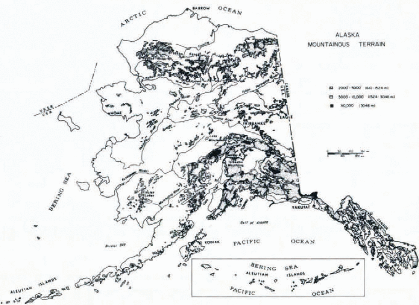
Fig. 5. Mountainous terrain in Alaska.
Table I. GENERALIZED AVALANCHE REGIONS IN ALASKA
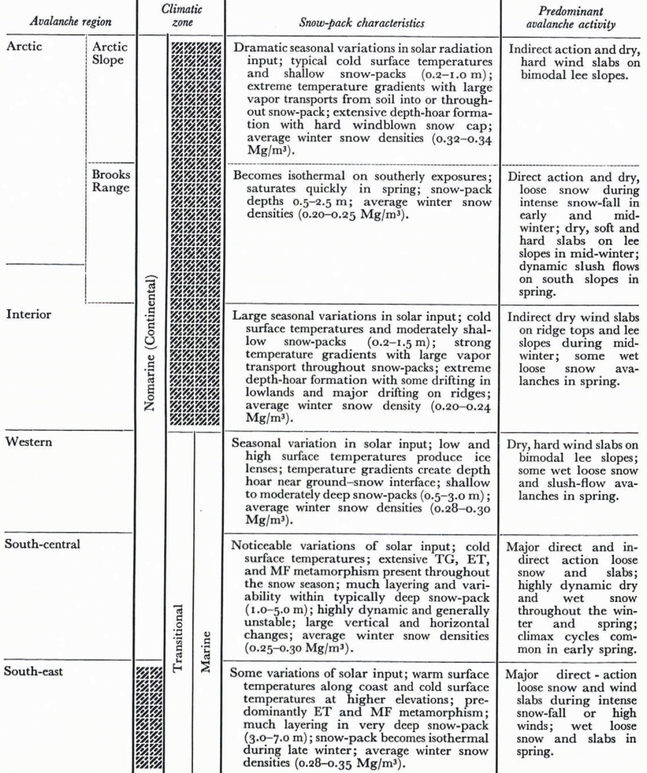
The Arctic avalanche region is north of the Arctic Circle (about lat. 66° 30' N.), and includes the Arctic Slope to the north and the Brooks Range to the south (Fig. 3). The snow—pack on the Arctic Slope has unique features which distinguish it from any other area in Alaska. First, the environmental factors of relatively similar snow and ground temperatures, small solar—energy input during the winter months, low air temperatures, large longwave radiative losses, typically shallow snow—packs (0.2—1.0 m) and a nearly continuous bimodal wind result in a steep temperature gradient within the snow—pack. The nearly continuous wind causes the surface of the snow—pack to be compacted into a very hard wind slab. The surface exhibits all forms of eolian erosional and depositional features such as drifts, dunes, ripples, and sastrugi. However, below the hard wind—blown surface veneer, a very loose depth—hoar structure extends to the ground. The prevailing and storm winds are generally bimodal (180° apart). Consequently, the lee slopes for one wind become the windward slopes for the other.
The second major feature of the Arctic region snow—pack is the speed with which the snow melts. In terms of energy balances and snow physics the Arctic snow—pack melts at the same relative '‘rate” as any other snow—pack. However, persistent low air temperatures cause the snow—pack to exist into the late spring or early summer, when the long hours of daylight begin. Once a warm air mass penetrates the Arctic, the combination of warm air (above freezing temperatures) and continuous sunlight causes the snow—pack to disappear within a few days.
Because of the vastness and remoteness of the Arctic region and its hostile winter environment, little is known or documented about snow—avalanche activity. However, considering the moderate snow—falls and nearly constant winds, it is suspected that the major winter avalanche activity occurs as minor hard and dry slab releases. With the advent of the spring thaw season (June) the rapid melting of the snow—pack is often accompanied by slushflow—type avalanches in the Brooks Range sub—region. The entire winter’s accumulation of snow in gullies (0.5—2.5 m) slowly slides down into mountain valleys in a very wet slurry (mixture of slush and water).
The central continental portions of Alaska generally include the area from the southern flank of the Brooks Range southward to the north and west crests of the Alaska and Aleutian Ranges. The Interior Region, the eastern two—thirds of the area between the Brooks Range and the Alaska Range, has an extreme continental climate. The mountain ranges surrounding the area isolate it from southern maritime influences. The snow—covered rolling topography (Fig. 5), northern latitude, and the taiga forest tend to produce intense temperature inversions. The snow cover lying within the altitude range spanned by the air—inversion layer (approximately 300 m above valley bottoms) is subject to negligible winds—usually throughout the entire winter. However, the tops of some of the higher hills penetrate the inversion layer and are exposed to wind effects (Reference Benson, Benson, Holmgren, Trabant and WellerBenson and others, 1974). At about 1 100 ft (300 m) above most of the valleys, some wind action on the snow surface becomes noticeable and significant wind—packing occurs at elevations above 1 300 ft (400 m) above valley floors. Thus, the snow—pack of Interior Alaska can be divided into two distinct types: the “taiga snow” found in the cold, calm lowlands; and the “tundra snow”, which is common on the top of the higher hills and ridges. The tundra snow is very similar to that described for the Arctic Slope sub—region.
In contrast, the taiga snow consists almost entirely of depth hoar. The extreme cold, relatively shallow snow—packs (0.2—1.5 m), “warm—moist” ground, and calm air conditions promote development of a depth hoar that has both the lowest density and largest cup—shaped snow crystals found anywhere (Reference BensonBenson, 1969; Reference SantefordSanteford, 1976). Snow—pack densities are generally near 0.20 Mg/m3 or less. The presence of extensive forests and gently—sloping terrain in the Interior uplands and plateaux creates areas of low to moderate potential for snow avalanches.
In the Western Region the weather patterns cause the snow—pack to exhibit several different features from those found to the north—east on the Arctic Slope. The storms which deposit the snow in Western Alaska originate either to the west (Siberia cold—front storms), or to the south (northern Pacific warm—front storms).With the different storm paths there are consider—able fluctuations in temperature. Variable storm occurrences cause subsequent metamorphism within the snow—pack. In the Arctic the prevailing winds (easterly) and the storm winds (westerly) are nearly 1800 apart and snow deposited by one wind direction is often eroded by the other. However, in Western Alaska the prevailing winds and the storm winds are nearly aligned with one another. Consequently the resident snow—pack is changed by both the prevailing and the storm winds throughout the winter. The absence of substantial forest cover exposes the snow—pack to the full wind force, resulting in extremely hard, dense wind slabs. In windswept areas the snow—pack is generally harder and denser than the surface layers found in the Arctic regions. In sheltered areas the warmer, more fluctuating temperatures coupled with greater snow—pack depths (0.5—3.0 m) tend to retard depth—hoar formation. However, an underlying depth—hoar layer commonly does occur, and is much shallower and less developed than that found in the Arctic to the north or Interior to the east. During the winter months dry slab avalanches generally occur on steep lee slopes. As with the Arctic weather conditions, the rapid spring warming often results in slush flow during late April, May, and early June.
The snow—pack of South—central Alaska has the greatest variation of any of the snow— avalanche regions within the state. These variations occur not only on an area—to—area basis within the region, but also seasonally at any specific location. The general storm paths, proximity to ocean water, and large orographic features, combine to form a full spectrum of climatic zones which include maritime, transitional, and non—maritime macroclimates. These differences are apparent from the coast inland and vertically from low to high elevations. The coastal mountains typically receive large accumulations of wet snow—fall (3.0—5.0 m) which are responsible for numerous permanent snow—fields and glaciers in the region. At sea—level the temperatures are often near the freezing point and temperatures cool moderately with elevation. Consequently, snow—packs adjacent to coastal areas in South—central Alaska are relatively warm and moist (approximately 32°F (0°C)).
As one proceeds inland from the coastal areas the snow—fall and temperature decrease considerably. Snow—fall on the leeward side of the Chugach Mountains (1.0—3.0 m) can be an order of magnitude less than near adjacent coastal areas. During the fall and early winter seasons the shallow snow—packs, low temperatures, and low solar radiation inputs combine to form extensive depth—hoar layers. Because the solar radiation is only 10—20 cal/cm2 d (400—800 kJ/m2 d) the energy budget and consequently the depth—hoar formation are nearly the same on all slopes regardless of aspect. The formation of depth—hoar layers early in November and December is a major factor contributing to early winter snow avalanches. As the winter advances to spring, the day length quickly changes (6—10 min/d). By the time of the vernal equinox (21 March) the daily solar energy input has increased twentyfold over the midwinter values (10 cal/cm2 d or 400 kJ/m2 d) and slope aspect becomes an important factor in the snow—pack energy budget. With the increased warming, south—facing slopes become subject to frequent late—afternoon avalanches. Point—source sluffing and deep—slab instability frequently occur during this time. As the season approaches 24 h of daylight, the effect of aspect again becomes less significant.
Further inland from the coast in South—central Alaska, snow—fall generally increases with increasing elevation to the Alaska Range. The snow—pack is drier and much colder than that found along adjacent coastal mountains. Air temperatures can be comparable to those found in Interior Alaska (—40°C or below). However, the mountainous snow—pack is frequently exposed to wind action. As in the other avalanche regions throughout the state, depth—hoar formation in South—central Alaska is common during early winter on all slopes regardless of aspect. Colder and lower temperatures above 10 000 ft (3 000 m) retard the equitemperature (ET) metamorphism process. Until after midwinter, loose—snow avalanches and all forms of dry—snow slab releases are common. Slope aspect can be an important factor in terms of wind action, but during midwinter periods aspect is insignificant in the snow—pack energy budget.
Seasonal changes in energy balance noted for the coastal mountains in South—central Alaska also are observed in the Alaska Range. However, at elevations above 10 000 ft (3 000 m) winter snow—pack conditions can persist into the “summer” period. As the season approaches the summer solstice (21 June) the effects of aspect on the snow—pack energy budget again become less significant. For example, a north—facing slope in the Alaska Range receives 90% of the solar radiation received by a south—facing slope during spring. By June the solar radiation input into the snow—pack has increased at least two orders of magnitude from the winter period. When melting temperatures are finally encountered at moderate elevations (about 5 000 ft (1 500 m)), the solar radiation input is nearly twice (400 to 500 cal/cm2 d, 16 to 20 MJ/m2 d) the input received during earlier melting periods at lower latitudes. With the 24 h day, the north—facing slopes are “warmed” by the sun during the night—time hours (6 p.m. to 6 a.m.). Melt—freeze (MF) and ET metamorphism rates are nearly the same on all slopes regardless of aspect by April in South—central Alaska. Surface snow sluffings are commonly seen on all slopes in April. At higher mountainous elevations above 10 000 to 14000 ft (3000 to 4000 m), where melting temperatures are generally not encountered, loose—snow and dry—slab avalanches can occur throughout the year.
The South—east region encompasses the coastal area along the north and eastern shores of the Gulf of Alaska and extends from about lat. 60° N. to 540 N. at the southern panhandle of the state. The area includes many mountainous islands of the Alexander Archipelago and the large Coast and St Elias Mountains further inland (Fig. 3). This region is exposed to most storm systems moving across from the North Pacific and the Gulf of Alaska. Consequently South—eastern Alaska receives large amounts of precipitation during both summer and winter. Due to the large latitude differences between the north and south boundaries of this region as well as the large elevation changes adjacent to coastal margins, considerable differences can be noted in the snow—packs at different locations within any area. During a given winter storm, rain may be encountered at the sea—level stations or at stations in the southerly latitudes. Cold, dry snow can fall at higher elevations or in the more northern portions of the region. In general the snow—pack for the South—eastern avalanche region can be described as relatively warm and deep (3.0—7.0 m). Variable temperature and moisture between frequent storms result in many layers within the snow—pack. Strong winds are common during both storm and non—storm periods. Snow conditions at any given location are highly dependent on slope aspect and relative location. The aspect or orientation of a slope relative to the storm path and the shadow effects of nearby peaks and cloud cover (Reference Hutcheon and LieHutcheon and Lie, 1978) are far more significant than are the aspect effects related to incoming solar radiation. Even at low elevations, below 2 000 ft (600 m), precipitation amounts can differ by an order of magnitude or more at adjacent stations located at the same elevation and a few kilometers apart. During one storm event the precipitation conditions may favor one slope orientation, while during another storm, snow—fall rates may be the same at comparable elevations but at different aspects.
With the frequent storms and heavy precipitation throughout South—eastern Alaska, loose snow avalanches occur frequently during winter storm periods. Strong accompanying storm winds often contribute to direct—action snow—slab releases. The wind shift which often occurs following the near passage of a storm front may be a major factor in forming direct—action wind slabs in the region. The effects of the strong winds in South—east Alaska are dramatic—wind speeds in excess of 200 m.p.h. (325 km/h) have been recorded along the ridge crests south of Juneau. These winds transport large amounts of snow and create hard snow surfaces, which can provide poor bonding surfaces for subsequent new snow, and may contribute to the occurrence of loose—snow avalanches during later precipitation events throughout the winter.
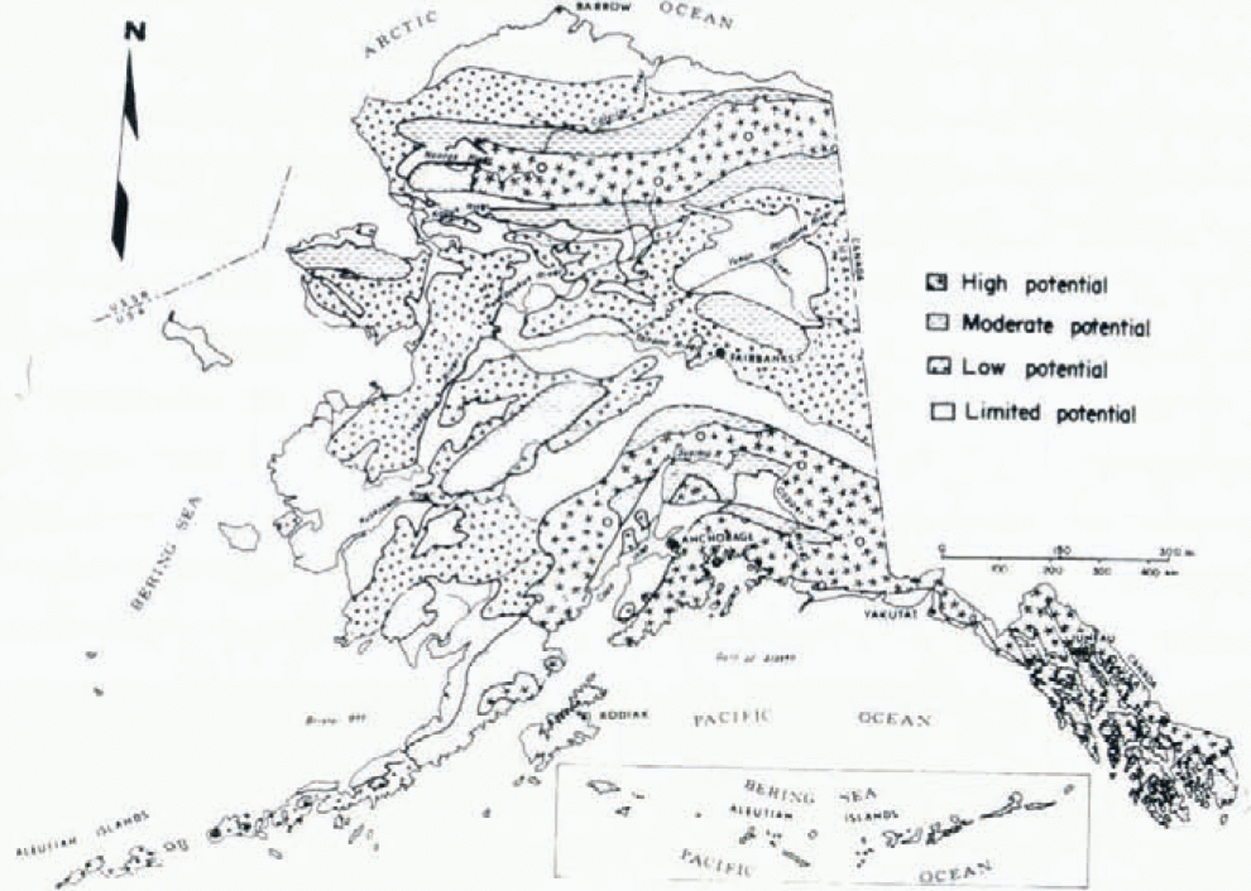
Fig. 6. Provisional snow—avalanche potential in Alaska.
Snow—Avalanche Potential
Compilation and cross—correlation of information on topographic relief, snow—avalanche regions, climatic zones, snow—pack characteristics, and known and suspected avalanche activity were used to produce a generalized avalanche—potential map of Alaska (Fig. 6). However, the state—wide avalanche—potential map includes regions with little or no data on snow—avalanche occurrences and therefore is provisional. Regional snow—pack conditions and seasonal climatic changes were assessed with the topographic features of each region and the potential avalanche terrain was identified throughout the state. Regions of “high avalanche potential” are areas where snow avalanches occur seasonally, and elevations above 10 000 ft (3 000 m) can expect potential avalanche activity throughout the year. Regions of moderate avalanche potential " have snow avalanches which commonly occur less than once every 1—5 years or occur during winters with unseasonably heavy snow—fall. “Low avalanche potential” areas have minor snow avalanche activity, but geomorphic, fire, or man—induced activities (i.e. logging, earth moving, etc.) could increase the potential for snow avalanches to occur. Regions of limited potential” are low and flat—lying areas which contain no known snow—avalanche activity.
In the Arctic Slope, Brooks Range, Western, and Interior regions, the existing data base does not warrant an attempted correlation between potential snow—avalanche hazard and known avalanche activity or accidents. However in two of the sub—regions, i.e. South—central and South—east Alaska, potential snow—avalanche terrain has been preliminarily identified using data on known avalanche activity through air photographs, terrain analysis, and documented snow—avalanche occurrences.
South—Central and South—East Alaska
Most of the mountainous areas in southern Alaska, because of their relative latitude, closeness to large masses of water, and large—scale orographic and cyclonic weather processes, are susceptible to major snow—avalanche activity. The sheer quantity and different types of new snow, caused by extensive altitude changes over relatively short distances, create major avalanche activity in South—central and South—eastern Alaska. The southern portions of the state are divided into three preliminary climatic/snow—pack zones—continental (nonmaritime), transitional, and maritime—on the basis of temperature, precipitation, geohydrological, and snow—pack data (Fig. 7). South—central and South—eastern Alaska contain areas that commonly encounter maritime and non—maritime climatic conditions in close proximity. These avalanche regions are generally transitional in character. Snow surface conditions can vary dramatically, depending on elevation, varying air temperatures, storm patterns, and local topography (U.S. Dept. of Agriculture. Soil Conservation Service, 1950—79; 1977—79 field studies). Large overburden pressures, significant temperature gradients, rapid migration of water (vapor and liquid phases), and high energy exchanges constantly modify snow—pack conditions throughout the snow season. Heavy monthly precipitation, from over 1.5 inches (38 mm) in the Anchorage area to about 5.0 inches (127.0 mm) in Juneau, and relatively low temperatures in the coastal mountains of southern Alaska favor over 28 000 square miles (72 520 km2) of permanent snow fields and glaciers (Reference Zenone and AndersonZenone and Anderson, 1978).
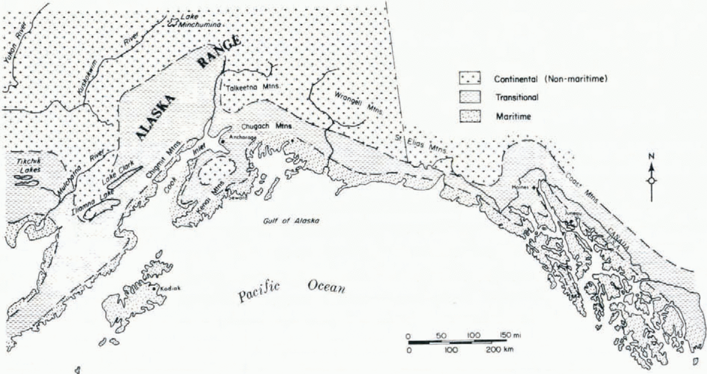
Fig. 7. Preliminary climatic snow—pack zones for South—central and South—eastern Alaska; based upon temperature and precipitation (US. Dept. of Commerce. National Weather Service / National Oceanic and Atmospheric Administration, 1970—78), geohydrological (modified from Reference Zenone and Andersonzenone and Anderson, 1978) and snow—pack data (U.S. Dept. of Agriculture. Soil Conservation Service, 1950—79, using 1977—79 data,and field studies by one of the present authors (S.W.H.)).
Storm, spatial (latitude, elevation, and topography), and temporal (month of year, day of month, and time of day) parameters largely determine the occurrence, frequency, and range of snow avalanches in any given area within the South—central and South—eastern portions of the state. The various combinations of meteorological and altitude conditions create a wide spectrum of snow—avalanche types (Table 1) which may develop during a snow—storm or may occur after a period of time following a number of winter snow—storms. Mountainous terrain (geographic location and relative elevation) and climatic/snow—pack zonation (Fig. 7) have assisted in depicting and identifying potential avalanche danger regions in the Anchorage area (Figs 8 and 9) and in the Juneau area (Figs 10 and 11) of Alaska. These basic data on topographic, climatic/snow—pack, and provisional snow—avalanche potential (maps in preparation by S. W. Hackett and G. Davidson) should assist in further delineation of snow— avalanche hazard areas in some mountainous areas in the region.
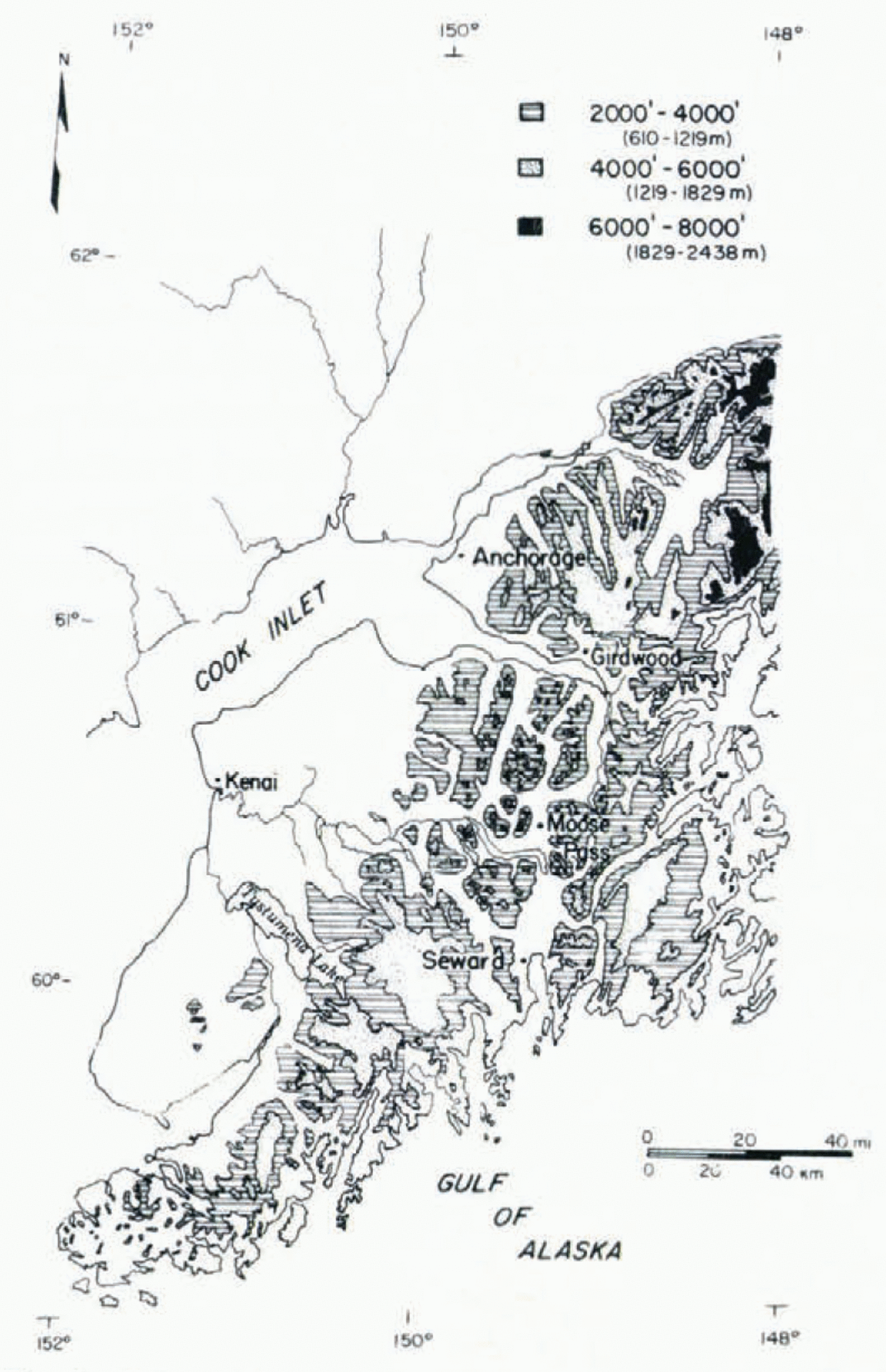
Fig. 8. Mountainous terrain in Anchorage area, South—central Alaska.
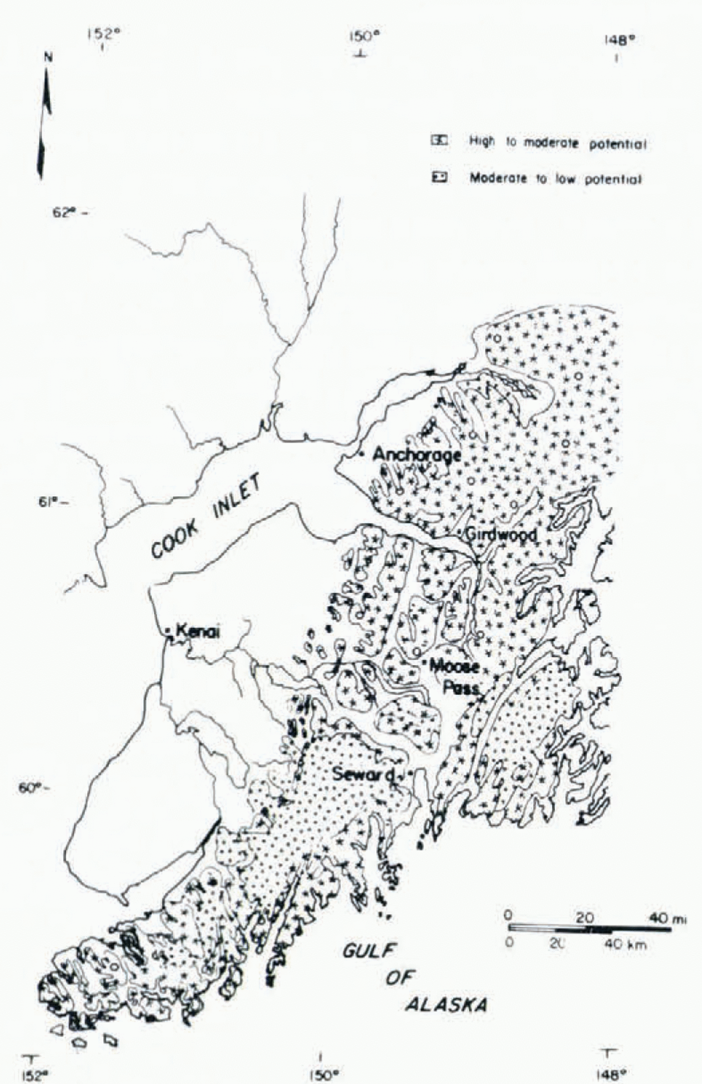
Fig. 9. Provisional snow—avalanche potential map, Anchorage area, South—central Alaska.
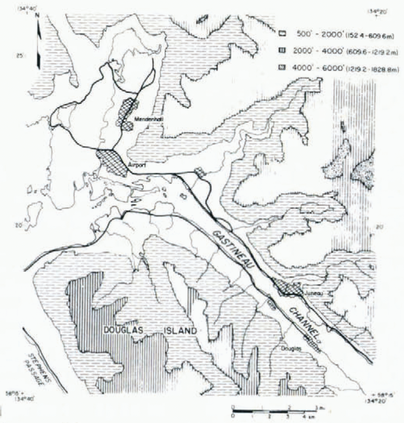
Fig. 10. Mountainous terrainin Juneau area, South—eastern Alaska.
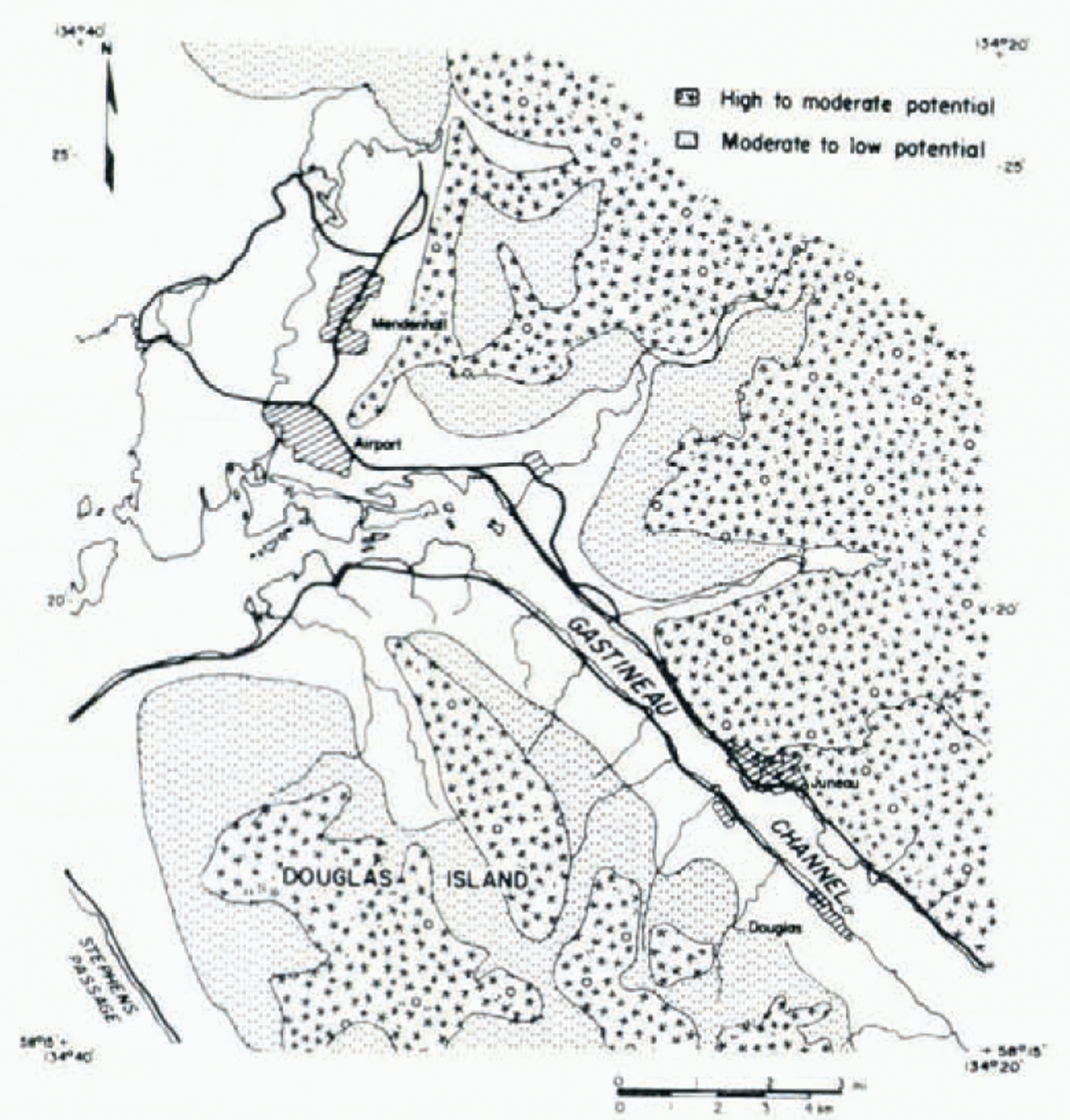
Fig. 11. Provisional snow avalanche potential map, Juneau area, South—eastern Alaska,
Avalanche Zoning
Although the current efforts by the Alaska DGGS do not establish snow—avalanche “zoning” per se, regional studies are seen as a required first phase in formulating a state—wide geologic hazard zonation and evaluation, Basic geological and geophysical information on snow—avalanche activity is required to support a meaningful land—use zoning program within the State. For example, seismicity within the mountain systems of southern Alaska (Fig. 3 has caused much avalanching in these regions of Alaska (Reference PlafkerPlafker, 1965; Alaska Geological Consultants, Inc., 1972). Only a few of the more than 2 000 snow and rock avalanches that resulted from the 1964 Alaska earthquake in South—central Alaska have been documented in detail (Reference HackmanHackman, 1965; Reference PlafkerPlafker, 1968; Reference HoyerHoyer, 1971; Reference Riehle and RiehleRiehle, 1977, 1978). Formal definition, identification, and delineation of snow—avalanche paths continue to be needed in the Juneau (LaChapelle, 1972; Alaska Geological Consultants, Inc., 1972) and the Anchorage areas.
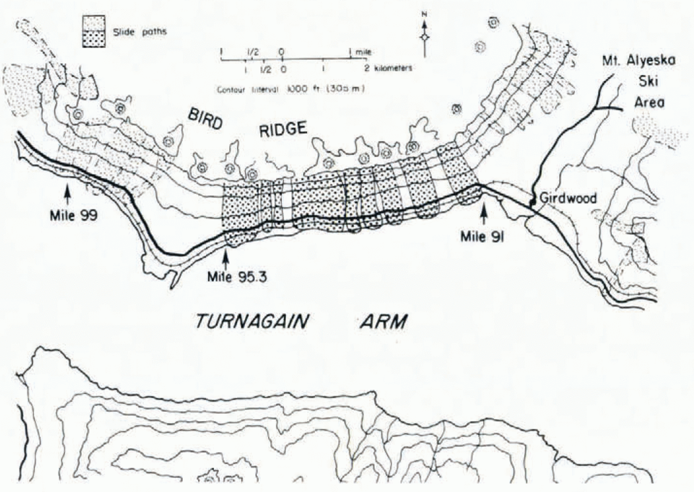
Fig. 12. Snow—avalanche activity map along Seward Highway near Girdwood, Alaska. This important highway and railroad corridor adjacent to Turnagain Arm south of Anchorage was recently blocked for over 48 h between Mile 95.3 and Mile 91. Massive snow slides came down and across the area during a climax avalanche cycle on 23 March 1979.
Geological information on snow—avalanche activity (Fig. 12) and detailed engineering investigations are needed by land—use and transportation—utility planners. Such information should be used and required for construction—site evaluation near snow—avalanche run—out zones.
The Anchorage Municipality in the South—central avalanche region and the Juneau Borough in the South—east region represent two areas within the state with high avalanche hazard. Local planning and zoning agencies have recognized the potential dangers and are beginning to address the problem. The Anchorage Municipality has established a Geotechnical Hazards Committee which has initiated Phase 1 of a preliminary study to assess the geological hazards within the Municipality boundaries (Fig. 9), which includes the Girdwood area (Fig. 13) to the south and the Eagle River area (Fig. 14) to the north—east. The contractual study will produce a series of maps (Reference Winterhalder, Winterhalder, Williams and EnglandWinterhalder and others, 1979) that delineate areas of high potential hazard. An accompanying report will recommend appropriate zoning and land—use classification to the Municipal Assembly.
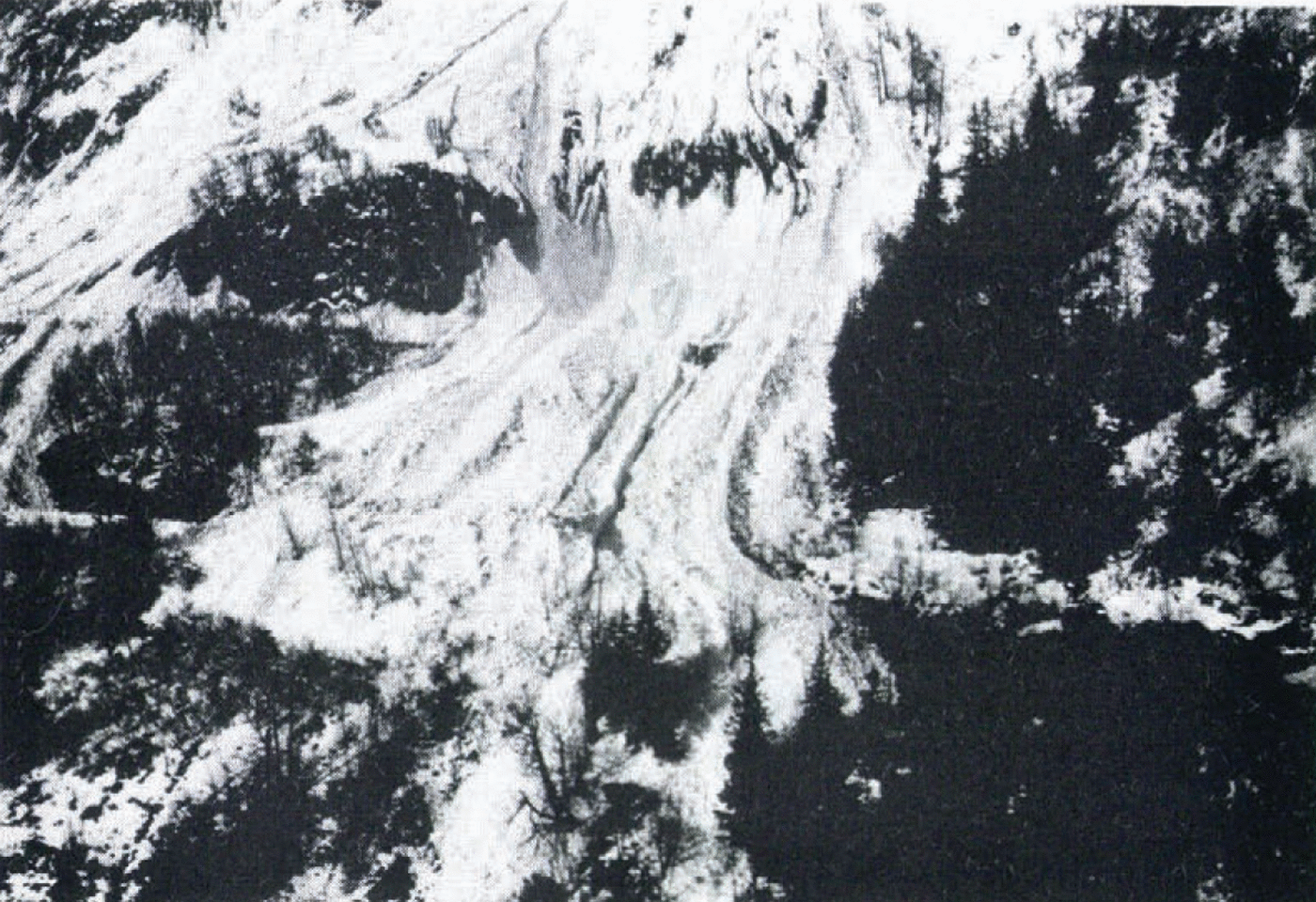
Fig. 13. Whiskey Gulch and an adjacent slide path, Mile 93, Seward Highway near Girdwood, Alaska. The snow slide is just one of over a dozen avalanche paths that released in March 1979 (photograph by S. W. Hackett).
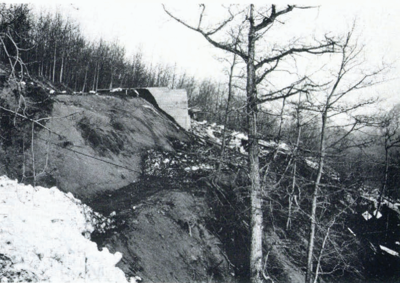
Fig. 14. The foundation remnants of a> $ 65 000 house that was completely destroyed by a wet snow avalanche during April 1979, Eagle River area, Municipality of Anchorage (photograph by J. Hackett).
The Juneau Borough utilizes a land—use and control—option system which offers some limited restrictions on land use in known hazardous areas. The Municipal Council has mandated that the city of Juneau Planning and Zoning Section prepare a land—use plan based on past studies (Reference HartHart, 1972; LaChapelle, 1972; Daniel, Mann, Johnson, and Mendenhall, 1972; Alaska Geological Consultants, Inc., 1972). This plan should consider the obvious problem of snow—avalanche hazard (Fig. 15) in the area. To date, no final zoning plan has been formulated. Development including single—family and multi—family dwellings is encroaching into known snow—avalanche paths and deposition zones (Fig. 16).
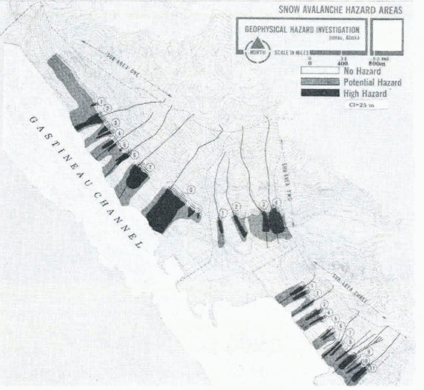
Fig. 15. Geophysical hazards map, depicting snow—avalanche hazard areas and zoning of Juneau, Alaska. The heavily shaded zones are those within known snow—avalanche paths; lighter colored areas indicate less dangerous but potential hazard zones; submitted to City and Borough of Juneau in 1972 by Daniel, Mann, Johnson, and Mendenhall, a planning and engineering consultant firm.
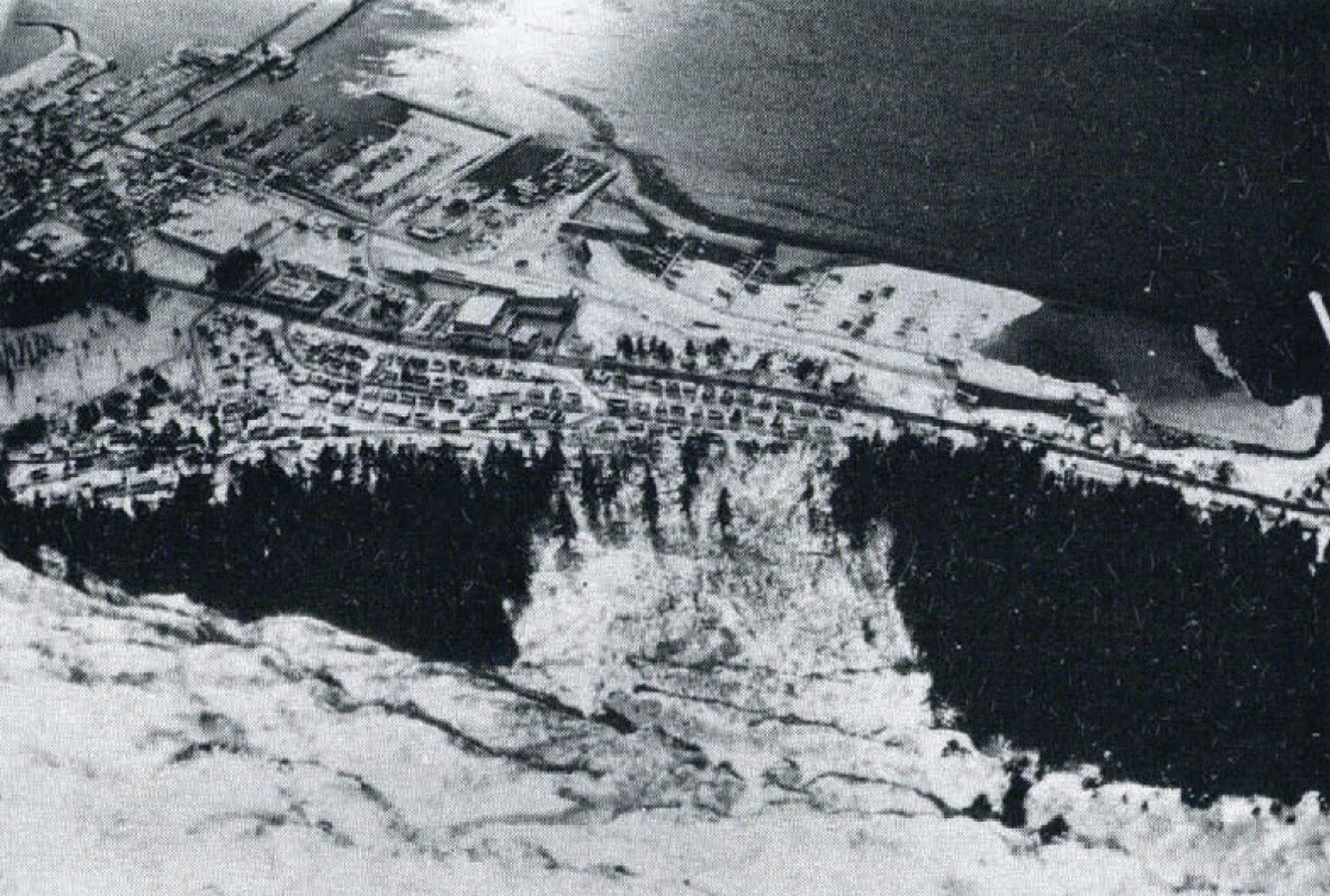
Fig. 16. Looking down the track from the starting zone of the Behrends Avenue avalanche path, Juneau, Alaska. The photograph was taken at approximately 3 ooo feet (9oo m) elevation looking towards the run—out zone adjacent to Gastineau Channel at sea—level (photograph by T. Laurent).
Conclusions
The state—wide regional data compilations and studies being conducted by the Alaska DGGS are beginning steps toward avalanche zoning in Alaska. Local planning and detailed investigations supported by municipal agencies are needed to establish effective natural—hazard zoning as related to snow—avalanche activity. When these efforts are viewed in conjunction with a newly proposed Alaska Avalanche Warning System (Reference Judson, Portland, Oregon, Daniel, Mann, Johnson, Mendenhall] and PlafkerJudson, 1979; U.S. Dept. of Agriculture. Forest Service, 1979), and an expanded avalanche awareness program (Reference Hackett and FeslerHackett and Fesler, 1980), the term “snow avalanche” may become familiar in Alaska. At the current rate of increased incidents involving the avalanche phenomenon (Fig. 17), formalized snow— avalanche zoning is seen as a high priority in South—central and South—eastern Alaska.
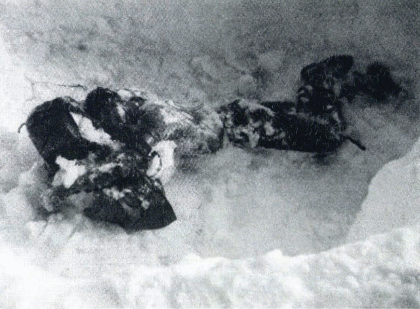
Fig. 17. Backcountry avalanche rescue mission in Chugach Mountains just east of Anchorage, Alaska (photograph by D. Fesler).
Acknowledgements
The authors wish to acknowledge the State of Alaska Division of Geological and Geophysical Surveys and the National Oceanic and Atmospheric Administration/National Weather Service for supporting our work. Doug Fesler of the Chugach State Park, and Jim Hackett, Snow Ranger in Chugach National Forest, provided stimulating thoughts on snow avalanche activities in South—central Alaska. Several colleagues of the Alaska DGGS assisted the senior author with various discussions about snow avalanches in Alaska. Drs Richard Reger, Randall Updike, and James Riehle, and Gail Davidson provided suggestions. Davidson compiled data on avalanche activity and terrain in the Anchorage and Juneau areas, and was assisted by Ann Schell in drafting the illustrations. Frank Larson edited the manuscript and drawings, and Roberta Mann typed the final copy. Drs Reger and Carl Benson (Geophysical Institute, University of Alaska) reviewed the paper. Although the authors have received much help from the State of Alaska and various U.S. Governmental agencies, the ideas and conclusions in this paper do not represent official policy within the state of Alaska.


