


Introduction: A Pareidolia
The Neolithic site of Çatalhöyük, in present-day Turkey, is famous for its wall-paintings discovered by James Mellaart in the early 1960’s. Many depict vibrant and often uncanny scenes, ranging from a swarm of humans harassing a gigantic bull, to a wake of vultures flying over headless corpses (Hodder and Meskell Reference Hodder and Meskell2011; Russell Reference Russell, Porter and Schwartz2012; Pilloud et al. Reference Pilloud2016). However, strangely, the most reproduced of the site’s murals is a much less dramatic geometric composition (see figure 1a). Puzzled by what its subject could be, assuming there is one, archaeologists have tended to insist on its idiosyncrasy (a “one-off,” says Hodder Reference Hodder2006: 147) and carefully avoid engaging in further interpretation, calling instead for reserve in the face of its uniqueness. But far from discouraging interest, this very ambiguity seems to have contributed in large part to the image’s public fame. Its vagueness encourages interpretation. Indeed, thanks to a short comment in Mellaart’s influential book, in which he tentatively compared this painting to a depiction of the site itself (Reference Mellaart1967: 176–77), it has come to represent in the minds of many the earliest map in history.
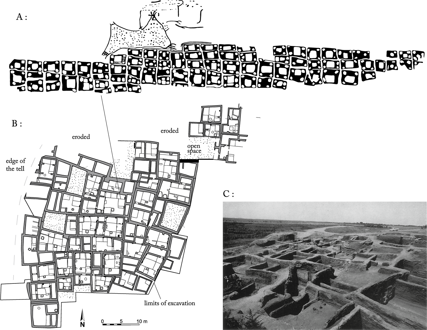
Figure 1. A: The Çatalhöyük “map,” wall painting from the north wall of “shrine VII” (redrawn from Mellaart Reference Mellaart1964b: pl. VI); B: plan of the excavated portion of the corresponding level VIB (redrawn for Mellaart Reference Mellaart1964b: fig. 2); C: general view of level VII as it appeared after excavation (Mellaart Reference Mellaart1964b: pl. 1, reproduced by the permission of the British Institute at Ankara).
It is easy to understand how such an interpretation was arrived at. As far as it is possible to tell from the current state of excavation, the 13-hectare site of Çatalhöyük consisted of an extremely dense fabric of standardized buildings with independent walls, all closely packed together, so that there was no gap between most of them (see figure 1b). Communication across the settlement, access to the buildings, social gatherings, and most of daily life, probably happened on roof terraces which are not preserved in the archaeological record. As such, when Mellaart described in the painting “a town with rectangular houses […] with internal structures” (ibid.), it was only logical for the reader to see in it something like a plot plan of the buildings as they actually appeared during excavation (see figure 1c). Then, at the top of the painting, dominating the town, Mellaart identified the two-peaked volcano of Hasan Daği—the eruption of which would have been witnessed by the inhabitants—and linked it to the importance of obsidian as a raw material for the settlement’s residents. He thus led readers to believe that this painting depicted not only a map of the town but also its relation to its hinterland. An impressionistic yet satisfying landscape of early Neolithic central Anatolia.
As a result, this image keeps popping up even in the most critical of studies in geography, urbanism, and the history of architecture (Soja Reference Soja2000; Casey Reference Casey2002; Dethier Reference Dethier2020). And yet, a topographical interpretation would have been dubious even for Mellaart himself. To begin with, although Hasan Daği may have been active when this image was painted in the first half of the seventh millennium BCE (Schmitt et al. Reference Schmitt2014), it does not present this particular profile when viewed from the site (Ülkekul Reference Ülkekul1999: 65–66), and the obsidian used for knapping by the inhabitants actually came from other, better-quality sources (Todd Reference Todd1976: 47; Chataigner Reference Chataigner and Cauvin1998: 292–93). Given these facts, it would seem more prudent to follow Mellaart’s first intuition and see this erupting figure as a freshly cut (and hence bloody) leopard skin, like those of the same shape that are sometimes depicted around the waists of human figures in other painted scenes found at the site (Mellaart Reference Mellaart1964a: 194; Meece Reference Meece2006). More fundamentally, the town plan itself could easily be seen as just another of the geometrical patterns that are quite common in Çatalhöyük’s wall-paintings (Düring Reference Düring2006: 192–95; Czeszewska Reference Czeszewska and Hodder2014). Unlike anything in the site’s spatial organization, the eighty or so rectangles are arranged in columns, their juxtaposition forming a motif so elongated that it covers two walls of the building in which it was painted.
Taken individually, these alternative hypotheses are certainly more plausible than reading the whole painting as a map. However, unsatisfyingly, they also fail to explain the odd association of these two themes on the same panel. The wish to reconcile the composition’s two parts seems to have been at the core of the reasoning behind Mellaart’s suggestion and is still very much part of its appeal today. The twin-peaked figure was only identified as an element of the landscape because of the architectural reading of the grid below. In this regard, it should be noted that Mellaart never spoke of a map, but of a “view of a neolithic town […] rising in graded terraces” (Reference Mellaart1967: 133), behind which the mountains would hence appear in perspective, their height magnified. He only suggested the “subjective (and perhaps controversial)” idea that the “internal divisions in the drawing” of the rectangles “remind one of the platforms, [benches, internal divisions,] etc., in the plan” of the excavated buildings (Reference Mellaart1964b: 55). Mellaart’s interpretation thus implies some sort of broken perspective taking in the connected plan of each building, seen from above, and their profile as a horizontal shape in the landscape, seen from the side as a whole. It is unclear if Mellaart understood this as a conscious mode of representation, which we now know existed earlier during the Levantine Neolithic—for instance in the way aurochs are profiled with a twisted head on the sculpted pillars of Göbekli Tepe and the nearby stela of Sayburç: Peters and Schmidt Reference Peters and Schmidt2004: 200; Özdoğan Reference Özdoğan2022—or if he voluntarily cultivated an ambiguity about it, as he notoriously did with other findings.
In any case, it would seem rather rash to discredit Mellaart’s idea on the basis of a very modern conception of geographical accuracy and linear perspective, since it elicits equally valid notions of “polycentric” and “reverse” perspective (Florenski Reference Florenski and Misler2002; Descola Reference Descola2021: 63–81). This essay will even venture to propose another non-cartographic, yet topographical reading of the painting, which I will argue is more in line with Neolithic relationships to the landscape and its representation. But in order to get there, it is important to first consider what this history of speculations about this particular wall painting might reveal about the very consequential preconceptions the contemporary viewer brings to neolithic visual and spatial culture. This image has been haunting me, as a student of the Neolithic, since even before I started working as a field archaeologist at Çatalhöyük, not because of the potential falseness of its interpretation on a cognitive (Hodder and Gürlek Reference Hodder, Gürlek and Hodder2020: 195–97) or a semiotic level (Edney Reference Edney2019: 69–71), but because of the ease with which we fall for these explanations. It is striking that, although its interpretation as a map was never clearly expressed, and in spite of the many subsequent mitigations, the idea that it is a map always has to be refuted since it keeps coming back with an unspoiled feeling of obviousness. Yet, we do not need to know much about the site, or about the Neolithic, to understand that this cannot be a map. It cannot be a map because it does not carry any meaningful geographical information expected of a map. The “plan” cannot be used to orient oneself or to mark any location whatsoever.
These very simple observations should be enough for us to understand that it is not actually a map that we want to see in this image, but the image of a map: a pareidolia. An image in an image, which is disconnected from everything we know about both the reality of the site, as it was experienced on several levels, and the technical diversity of mapping systems used in various historical contexts. Mellaart was actually quite on point when he first described this image as something that “vividly reminds of the plan of a town” (Reference Mellaart1964a: 194, my emphasis). The Neolithic people of the Levant and Anatolia may have had their own system of geographical information, maybe even a cartographic one, but it is dubious as to whether they would have chosen to represent it in the form of a plan. Furthermore, if they had only wanted to symbolize the settlement, without intending to map it, it would have been an even more peculiar choice to do so by drawing a ground plan of what was hidden below the lively, open roof-terrace level.
Ichnographic projection was not unknown in premodern times. Famous examples, designed to communicate a totalizing image of a city in the context of major changes and public works, include the Forma Urbis Romae and the plan of Nippur (Talbert Reference Talbert2012). A powerful way to evoke finite forms, it could be used to praise a builder’s achievement, as in the ground plan of the temple of Ningirsu, placed on the lap of the neo-Sumerian sculpture of king Gudea and sent to him in his dreams by the Deity itself (Bahrani Reference Bahrani2014: 101–5). However, recognizing such a specific and politically loaded convention in a motif that does not reflect the physicality of the site, let alone its phenomenality, speaks volumes of how our eye is informed by the modernist “ideal” of cartography (Edney Reference Edney2019). When presented with a grid, we are left with an impression of mapped space which, far from being an obvious conclusion of imagining the site from above, is actually an abstraction. Unlike a bird-eye view, it necessitates a point of view that is impossible to achieve in reality, because it vertically overlooks every point of the surface simultaneously. Rather than assessing how this image might represent a Neolithic town, we are indulging our own very peculiar modern cartographic symbolization of space. It is the spontaneity with which we do this, rather than our capacity to speculate, that should be called into question.
Our shared inclination to see a map in this painting betrays our will to discover in it proof, not only of the full achievement of the “domestication of space” during the Neolithic, but also of its conquest by means that are all too familiar to us; that is, by rendering space as straightened, transparent, and frozen in time, a space that can be measured, objectified, and appropriated. As an image, this painting thus works as a sort of Rorschach test. It captures in a nutshell all that we project onto the emergence of sedentism as the presumed direct origin of our own settled way of life. How we read this image matters because it reveals the specter of Modernity that continues to haunt our relationship with the Neolithic.
If we are to ward off this specter it is thus necessary to combine our knowledge of the Neolithic, which has grown considerably since Mellaart’s excavation of Çatalhöyük, with the insights arrived at through the many critical analyses that have contested modern conceptions of space and architecture. It is not enough to call into question the anachronism inherent in interpreting this painting as a map. This particular case provides us with the opportunity to decenter our general relationship to the Neolithic by asking the question: how does this anachronistic interpretation correlate with contemporary critiques of the modern representation of space?
Beneath Representation
In La Production de l’espace, Henri Lefebvre (Reference Lefebvre1974: 48–65) provides a useful way of disentangling notions surrounding the above question’s central term: space. For Lefebvre, what we call “space” encompasses a triad of interacting elements:
-
1. the “representation of space” which is the instrumental notion of space as we order, conceptualize and plan it;
-
2. “spaces of representation” or space appropriated by the imagination, which acts as a medium for meanings such as in the evocation of awe, wonder, hope et cetera;
-
3. “spatial praxis” which is space as a field of perceptions and actions, lived spaces as we interact with them daily in the most sensorial of ways.
For Lefebvre, the process of abstraction that underpins modernity’s view on mapping originated when the “representation of space” became a totalizing worldview dominated by state planning and a systematic enterprise of quantification through capital (ibid.: 309–33). This is not to say that the notion of space is reduced to its representation by the means of plans—which would indeed be a modernist fantasy—but rather that this historically specific representation of space only took precedence by being continuously engaged in “contradictory manners” with the two other elements of the triad, which are subject to much more variability. On the one hand, spatial praxis and spaces of representation always have to be subjugated, anticipated, or co-opted in order for the representation of space to operate. On the other, more efficiently than any other alternative worldview, they are always in a position to undermine the modernist ideals of order, predictability, efficiency, and profit.
In the context of modernity, even a map (and maybe especially a map) can produce this insubordinate, evocative, and moving effect once it is seen as a space of representation instead of an instrument of representation. There is an aesthetic of maps as an invitation to get lost which speaks as much to the imagination as anything else. Conversely, the Çatalhöyük painting provides a good example of how the modern representation of space can subvert the most unsettling spaces of representation. Even though Mellaart evoked the prospect of a terraced town, imaginatively “portrayed in the way children will draw” (Reference Mellaart1964a: 194), from several different angles, with a mighty volcano erupting in the background, we only see a spatial pattern inasmuch as we see (or resist seeing) the kind of plan a geometer would draw. Although it might be tempting to find in abstraction a key for a non-representational interpretation of the painting, this prevalence of two-dimensional geometry is connected to a wider register of representational interpretation of Neolithic visual culture. Aside from the now-outdated rhetoric of progress, its timeless sense of objectivity remains as one of the last indisputable indexes of social evolution. Peter J. Wilson thus claimed in an influential book, “We are the direct heirs of Neolithic geometry,” from which is supposed to derive not only “the cosmological significance of the house and village,” but also our own “tonal music, perspective painting, architecture, mechanics, ballistics, formal gardens, town planning, and theater, to mention but a few” (Reference Wilson1988: 152). Awareness of the instrumental importance of geometry in the modernist vision of the world, of its crucial role in the colonial enterprise and state-building, has not prevented more critical authors from tracing back to the Neolithic the origin of the very same idea of taming, ordering, and “simplifying the profusion of nature” (Scott Reference Scott1998: 262). In this respect, interpreting the Çatalhöyük pattern as an abstract grid, rather than a map, is not so much an alternative interpretation as it is a naturalizing prerequisite.
Significantly, Mellaart credited the architect of the team as being the first one to identify the rectangular shapes as buildings (1964a: 194), but it is no less telling that this link was then justified by its visual similarity to the excavation plan. Alongside architecture, archaeology has played a major role in the empowerment of the modern representation of space conceived as neutral, atemporal, and isotropic. It expands the architectural instrumentality of the plan into a descriptive tool that provides a “social constant” in the comparison of spatial cultures (Smith Reference Smith2003: 34), while the remoteness and the incompleteness of an object, which often disappears in the process of its recording, makes it easier for abstraction to get the upper hand in representation. Through this lens, the past easily appears as the most docile of foreign countries. Possible divergences in the field of representation are overshadowed by the measurable objectivity of a referent that only appears in light of the image used to record it (Lefebvre Reference Lefebvre1974: 341–46; Leach Reference Leach, Green, Haselgrove and Spriggs1978). Formal “analyses” of the plans of early permanent architecture are thus presumed to unveil the simplest manifestation of the concepts which underly the site’s practical, and sometimes confusing, uses and modes of construction. As recently as 2020, the monumental “enclosures” of Göbekli Tepe, despite their irregularities and convolution, were described as nothing short of a “quantic jump” in geometric design and planning (Haklay and Gopher Reference Haklay and Gopher2020: 354). In trying to mitigate the extreme feelings of estrangement elicited by these sites by confounding the lived territory with the conceptualized map, this way of thinking falls prey to a level of Borgesian fantasy matched by few other fields of knowledge.
The paradox is that archaeology is also full of spaces of representation. Ruins, abandoned places, ancient castles, and cemeteries, whether real or fictional, have nourished the modern imagination with some of its most unsettling, eccentric, and indeed subversive motifs. As such, even before dealing with its odd symbolism, a multi-level agglutinated neolithic town, with its obscure recesses and its confusingly integrated architecture, should be enough to challenge our representation. Although the imagery produced by archaeological surveys and excavations might easily evoke a modernist utopia, the sites are, in themselves, a paragon of what Foucault (Reference Foucault1984) termed a “heterotopia” in as much as they are constituted in relation to our own imagination, albeit confrontationally. They are places so evocative that they have to be tamed, monuments that always call for re-monumentalization. That is why it is not just the scarcity of sources which makes questioning prehistoric spaces of representation on their own terms a virtually impossible task. Although visual culture, such as neolithic painting, might hint at representations of space that differ from ours, archaeology can explore these in a much more direct way by examining the way people engaged materially with their environment, or what Lefebvre termed spatial praxis.
The dialectics between the modern representation of space and spatial praxis lie at a different level than with spaces of representation. It always comes down to the same issue: unlike maps and plans, space is full of living bodies. Modern governance endeavors to counter the indiscipline of practices by individualizing acting bodies, anticipating their needs and monitoring their behavior. However, these efforts are always met by contradictory forces, whether it is through collective and often festive uprisings claiming back a “right to the city,” as Lefebvre put it (Reference Lefebvre1968), or in the way that practices never quite follow intended function, thus creating new ones. This multitude of everyday “tactics” act in opposition to institutional “strategies” (Certeau Reference Certeau1990). Their direct material effects, the reactions they trigger and the continuous attempts to preempt them make spatial praxis an integral part of the production of space. Not only does it influence the representation of space, but it also questions the prevalence of these representations. In other words, praxis is always a preexistent quality of space inasmuch as it opens up another perspective on its dynamic and transformative nature. Although the discipline historically developed on a totally different line, this resonates perfectly with the scope of archaeology (Pauketat Reference Pauketat, Dobres and Robb2000; Hodder and Cessford Reference Hodder and Cessford2004; Richard Reference Richard2018): rather than being conceived of in a modernist way, as solely the outcome of top-down planning, coercion, or a demiurgic will, the production of space appears at the intersection of both the embodied and institutionalized, congruent and divergent practices at play in the actual formation of the archaeological record.
But the archaeological resonance of the notion of spatial praxis is temporal as much as material. What is at the core of the friction between spatial praxis and the representation of space is the modernist confidence in the fixity and completeness of forms: that is, the notion that the perenniality of architecture could be, in itself, a means to shape, satisfy, or stabilize social relations; or—and this is the problematic foundation of many archaeological lines of reasoning as much as of many colonial utopias—that it is actually possible to redefine social relations solely through the establishment of new forms. The price of such reasoning, of course, is the absence of temporality, but not in the chronological sense of the linear succession of discrete homogeneous periods. “Whereas strategies rely on the resistance that the founding of a place puts up against the ravages of time,” says Certeau (Reference Certeau1990: 63), “tactics bet on a crafty use of time.” In spatial praxis, time matters inasmuch as it is broken up into bits of duration, ruptures, and repetition. Whether it ends up reinforcing or subverting the order of representation, praxis activates what Bakhtin terms the “grotesque in history,” that is to say that which acts as an antidote to the “limited seriousness and pretense of extratemporal meaning and the unconditional value of necessity” (Reference Bakhtin1984: 49).
Put another way, rhythm is a blind spot when it comes to the modern representation of space as a succession of uniform planes (Lefebvre Reference Lefebvre1974: 235–38), whether it is in the “idiorrhythmic” of nevertheless “coordinated” bodies (Barthes Reference Barthes2002; Gan and Tsing Reference Gan and Tsing2018), the seasonality of societies (Wengrow and Graeber Reference Wengrow and Graeber2015; after Mauss and Beuchat 1904–Reference Mauss and Beuchat1905), or the sequentiality of history (Gordillo Reference Gordillo2014; Schnapp Reference Schnapp2020). Moreover, in that it differs from measure, rhythm is also expressive. It connects representation and praxis in a totally different way than we are used to. As Gilles Deleuze and Félix Guattari stated in a famous discussion about the “ritournelle” (translated as “refrain” in English), rhythm is the main force of territorialization. By that, they mean the living process of constituting a new relation to the environment, and maybe even the only one that structurally matters, for it allows a landscape to be decoded and hence transformed as an assemblage of motifs and melody, rather than reproduced and transcoded by the fixity and wholeness of images (Reference Deleuze and Guattari1980: 382–97). It is for this reason that critiques of modern representations often call for “rhythmanalysis” (Bachelard Reference Bachelard1936: ch. 8; Lefebvre Reference Lefebvre1992; Edensor Reference Edensor2010). It is how, given the colonial and pacifying instrumentality of the representation of space, “many subaltern histories that resist capital are not always fully absorbed by modernity’s temporality” (Verdesio Reference Verdesio2022: 221). Finally, it is also why that is a relevant starting point from which to think afresh about ancient spatial praxis and, maybe, to speculate about associated representations in a way that allows them to decenter our own.
This reference to a rhythmanalysis often takes the form of a call for a yet-to-be-discovered “remedy” for the alienation created by modern space and its representation. Lefebvre, for instance, suggested that what psychanalysis can do to the human mind (as a space of representation), what rhythmanalysis could do to the acting body (as the vector for spatial praxis). What’s missing here, though, is a grasp of the generative effect of rhythm itself, as emphasized by Deleuze and Guattari. Just as Freud (Reference Freud2002[1930]) famously used the archaeological metaphor of the Eternal City as a palimpsest to uncover the unconscious stratification of the mind, one could think of a similar deepening and dynamic sensibility as necessary in order to perceive the temporality of lived spaces beneath representation. In the absence of living bodies, materiality can provide such a sense of “unconformity” (Raffles Reference Raffles2020). Archaeology does not only counter the modern representation of space by unearthing unsettling spaces of representation from the past—even the most familiar representations can be unsettled by its representational quality, the kind of “fragmented” (González-Ruibal Reference González-Ruibal2013) and “heterogenous” (Dawdy Reference Dawdy2016) dimension it reveals in the making of a cumulative continuity.
The emergence of sedentism during the Neolithic lends itself particularly well to such questions, for it crystallizes both ends of the issue. When we see the Neolithic as a great revolution in the history of humankind, it becomes the natural receptacle of our totalizing misconceptions (Finlayson and Warren Reference Finlayson and Warren2010; Hadad Reference Hadad2020); we are legitimizing them by reenforcing their pretension to universality. But at the same time, the archaeology of the Neolithic now provides us with an opportunity to understand, empirically, how humans constitute new territories in the long run. By unsettling the finalism of modern representations, it shows us, with a great deal of detail, what an alternative dynamic relationship to space might look like.
On the Precedence of Stones
The specialist of prehistoric Near Eastern architecture Olivier Aurenche once pointed out a paradox about the Natufian Epipaleolithic period (ca. 13,000–9,500 BCE), when groups of “hunter-gatherers” are supposed to have settled down in small “hamlets.” Noticing the common use of dry stones as a building material (see figure 2a), he was struck by the fact that this practice nearly disappeared thereafter, with the bigger and better-established sites of the Early Neolithic favoring lighter construction techniques involving earth materials (Reference Aurenche1981: 43). Why, he wondered, does sedentism seem to start with the strongest proof of architectural investment and permanence? Is this not the inverse of what we would expect the normal order of progress into sedentism to be at the beginning of the Neolithic?

Figure 2. A: Early Natufian stone architecture from ‘Ain Mallaha (Israël), “house 51/131” (archives Jean Perrot, MSH Mondes - Nanterre, courtesy of Danielle Perrot); B: PPNA earth wall with an inner stone frame, Dja’de el-Mughara (Syria), “communal building” (photo of the author); C: PPNA earth architecture (cobb) from Klimonas (Cyprus), “building 10” (photo: Vigne, CNRS).
Although this judgment is now a little bit outdated when it comes to the Neolithic use of stones or the deep history of sedentary practices in the Levant, as we shall see later, the general idea is still representative of the way we interpret Natufian sedentism—or rather, of the way we struggle to do so. For the Natufian has long been a sort of a conundrum in the way it cumulates contradictory proofs relating to the traditional way of thinking about sedentism. Some Natufian sites characterized by durable stone architecture (such as ‘Ain Mallaha, Wadi Hammeh 27, el-Wad or Shubayqa 1) show strong signs of year-round occupation: in the complementarity of seasonal resources or in the presence of commensal species such as the house mouse (Yeomans, Richter, and Martin Reference Yeomans, Richter and Martin2017; Weissbrod et al. Reference Weissbrod2017; Rivals et al. Reference Rivals2020). At the same time, these sites are also marked by phases of abandonment and reconstruction, in which we see no regularity and no pattern (Valla Reference Valla1988; Hardy-Smith and Edwards Reference Hardy-Smith and Edwards2004; Samuelian Reference Samuelian and Gheorghiu2010). It is as if the sites could be occupied for long periods, abandoned for reasons about which we can only speculate, only to be reoccupied sometime shortly afterward or sometimes decades later (Shewan Reference Shewan and Delage2004; Yeshurun et al. Reference Yeshurun2014; Richter et al. Reference Richter2017).
In order to tackle this seemingly counter-intuitive relation to the sites, the literature on the Natufian traditionally relies on a discussion of their function as the “basecamps” within a wider territorial structure (Bar-Yosef and Valla Reference Bar-Yosef and Valla1991), and on an ongoing discussion of the effect of climate change (Maher, Banning, and Chazan Reference Maher, Banning and Chazan2011; Grosman et al. Reference Grosman2016). Whatever the case, it is striking that once placed within the chronology of Levantine prehistory, those sites are always singled out. Although there is a consensus about the importance of mobility during the Natufian (Valla Reference Valla2018; Santana et al. Reference Santana2021), the presence of stone architecture is still seen in the same literature as a milestone in the path to sedentism. It is as if the paradox pointed out by Aurenche is reversed to create a less gradualist but more triumphalist notion of evolution: Natufian stone architecture is almost seen as a statement, as a necessary radical first step to open the way toward the humbler peasant way of life that we like to associate with the Neolithic.
Clearly, part of the problem lies in the vocabulary itself, since the word sedentism fails to apprehend the reality of the prehistoric context, especially in its quite anachronic opposition to nomadism (Boyd Reference Boyd2006; Maher and Conkey Reference Maher and Conkey2019). The idea of semi-sedentism that we often use to describe the Natufian perpetuates this issue by trying to navigate quantitatively between two abstract ideals. The key issue, here, is the impression that permanence can be used to measure sedentism. By doing so, we perpetuate confusion as to what we are actually talking about: Do we mean the permanence of the occupation? The permanence of the site? Or the permanence of the buildings themselves? The Natufian period shows that these three dimensions do not have to be congruent. Instead, it leads us to think of attachment to places and forms of mobility as two non-contradictory variables. This makes the so-called paradox of the antecedence of stone compared to earth much more interesting.
The early Pre-Pottery Neolithic A (or PPNA, ca. 9,500–8,500 BCE) settlements that succeed the Natufian show an almost complete opposite combination, in which the permanence of the occupation is totally disconnected from the permanence of buildings. As archaeologists all too often discover with the sites they excavate, earth architecture deteriorates quickly under the marked seasonality of the Near East (Torraca, Chiari, and Gullini Reference Torraca, Chiari and Gullini1972; Margueron Reference Margueron2013; Matero Reference Matero2015). Winter rains would have forced the inhabitants to engage in renovation works at least once a year, with practices such as replastering and ramming or rolling surfaces happening at a much faster pace (Thoumin Reference Thoumin1932; Wulff Reference Wulff1966; Seeden Reference Seeden1985). Whether they were built using adobe (sun dried bricks) in the southern Levant and the Tigris valley or cobb (wet applied earth) in the Euphrates valley, PPNA archaeological remains do indicate the importance of such practices. Preserved indoor surfaces were very often re-plastered, whereas the outdoor parts disappeared unless they were quickly buried (Aurenche Reference Aurenche and Margueron1980; Kenyon Reference Kenyon1981; Kozłowski and Kempisty Reference Kozłowski and Kempisty1990; Mithen et al. Reference Mithen2018). The use of stones within earth walls on some sites such as Jerf el-Ahmar (Stordeur Reference Stordeur2015) or Dja’de el-Mughara (Coqueugniot Reference Coqueugniot, Manen, Perrin and Guilaine2014; see figure 2b) can give a false impression of permanence. Although they serve to improve durability as a foundation layer (preventing the capillarity or stagnation of water) or as inner frame (for mechanical improvement, especially in the case of subterranean or quadrangular structures using cobb, rather than adobe), they were not (with some exceptions which will be addressed later) actual supporting elements, and thus they would not have prevented structural failure.
As a material, earth can be extremely technical to excavate; it tends to produce shapeless-seeming ruins unless it has been subject to the right taphonomical conditions (Claasz Coockson Reference Claasz Coockson2010; Friesem et al. Reference Friesem2011). PPNA sites can be reduced to very scarce remains when exposed to a more humid Mediterranean climate (see figure 2c) or when they are not occupied long enough to generate a protective layer of debris (Vigne et al. Reference Vigne, Vigne, Briois and Guilaine2023). But while this bias, and the way it affects the representativity of remains, is now increasingly recognized, another more theoretical dimension of it is still prevalent in our general way of appreciating the site formation process. When faced with the intrinsic fragility of earth architecture, as opposed to the enduring quality of stones, we tend to think of the repetitiveness of these practices as an unfortunate constraint. Of course, we are well aware of the constant need to renovate any kind of architecture. However, we think of this as a way of returning the structure to its original form, to start afresh while maintaining a sense of permanence.
This process appeals to our architectural imagination for the same reasons we are attracted to stonework’s ability to retain its form even when in ruins. The Swiss modernist architect Le Corbusier (Reference Corbusier1959[1925]) even had a name for this: he called it the “law of Ripolin” (a brand of whitewash paint renowned for its resistance to weathering). Despite sounding very practical, here we are firmly in the field of representation. The Villa Savoye, Le Corbusier’s manifesto of modernist functional purity built in 1931 in the Parisian suburbs, provides a perfect example. Ironically enough, this “machine for living” was soon deemed to be uninhabitable by the inhabitants themselves, not because of the radicalness of forms, but because those forms could not be changed or touched in an effort to improve livability. The inhabitants soon realized that they were not living in a building, but in the image of a building (Colomina Reference Colomina1994). Its pictures were already being published as a new canon even before its completion (Giedion Reference Giedion1930). In the forty years or so after its construction, while these images were being reproduced as the symbol of a “new tradition” (Giedion Reference Giedion1941), the villa itself was meeting some unexpected needs: it first became a hay barn, and then a ruin that served as a playground for children (Murphy Reference Murphy2002). It was only decided that it should be monumentalized and refurbished in the 1970s in reaction to the scandalous images of the building performing its latest function appeared in MOMA’s 1966 exhibition “Destruction by Neglect,” and in Time Magazine’s 1959 article “Stompin’ the Savoye.” However, by then, the process was contradictory, for not only did it aim at extracting the building from the fortuitous contingencies of time, but it achieved that goal of fossilization by “restoring it into a state that has never really existed” as Viollet-le-Duc famously put it (Reference Viollet-le-Duc1866: 14), or that only existed virtually (in photographs, in the case of the Villa Savoye).
We are inclined to fall into the same trap when thinking about the repetitiveness of neolithic architectural practices; we like to find “morality in whitewashing,” as Le Corbusier put it (Reference Corbusier1959[1925]: 191), because it complies with an ideal of an eternal present, the ultimate triumph of form over time. The law of Ripolin is the futile effort to reconcile praxis and representation along this line, or in Le Corbusier’s words, “construction” as something that lasts (into dilapidation) and “architecture” as something we are moved by (albeit essentially as an image). This is especially surprising if one considers that the practical novelty of modernist architecture as theorized by Le Corbusier, with its free plan and its modularity, is its invitation to appropriation through change by the inhabitant (Boudon Reference Boudon1972). Rather than appreciating the irony the “house of Augustus turned into a hay barn” without losing anything of its esthetics (Diderot 1876[1767]: 240), modernist representation expects us to remember an improbable time when “the cathedrals were white” (Le Corbusier Reference Corbusier1937).
Although this representation conjures up the authenticity of the past in the present, it is anti-archaeological in principle. Yet, this is the same representation that we project onto the past when we confuse the permanence of occupation with that of the buildings, or of the site itself. And this is precisely the representation we have to break with if we want to have a chance of understanding why the Natufians built in stone, and why the PPNA embraced a path that forced them to keep replastering and reconstructing their living environment. In order to gain an understanding of what is at stake in the emergence of Neolithic sedentism, as a transformation in spatial praxis, one must set aside its appearance as measurable permanence, and instead think of it as a change in the way people dealt with the impermanence of forms. To be sedentary is to invent new ways to compose with the finitude of things.
Many researchers have outlined the importance of plasticity and fluidity as a positive attribute of earth as a material (Wengrow Reference Wengrow1998; Weismantel and Meskell Reference Weismantel and Meskell2014; Buchli Reference Buchli and Hodder2014). For the inhabitants of PPNA settlements, this would certainly have resonated with other aspects of their life. This period witnesses the first systematization of “pre-domestic” cultivation, as evidenced, among other things, by the presence of chaff incorporated into building materials (Weiss, Kislev, and Hartmann Reference Weiss, Kislev and Hartmann2006; Willcox, Fornite, and Herveux Reference Willcox, Fornite and Herveux2008; Asouti and Fuller Reference Asouti and Fuller2013). The main sites were situated next to highly seasonal sources of water flow allowing recessional cultivation, whether the alluvial fans of wadis such as in Jericho, Netiv Hagdud, or Wadi Faynan, or the banks of the Euphrates River, which back then was not only prone to spring flooding but also constantly changing course (Bar-Yosef Reference Bar-Yosef1986; Geyer and Besançon Reference Geyer and Besançon1996; Sherrat Reference Sherratt, Colledge and Conolly2007). Alongside other strong markers of socializing seasonality, such as a transformation in hunting practices focusing increasingly on large migratory ungulates (Gourichon and Helmer Reference Gourichon, Helmer and Ibañez2008; Lang et al. Reference Lang2013), the periodic reconstruction of earth architecture is in step with this fluctuating environment.
In the higher Tigris valley, by comparison, an early parallel tradition which follows a different ecological path, privileging fluviatile resources and ignoring cereal cultivation, relied more on stone for construction (Itahashi et al. Reference Itahashi2017; Kabukcu et al. Reference Kabukcu2021). Stone-built Natufian settlements, for their part, were abandoned in the establishment of the PPNA relations to the Levantine landscape, while their surroundings would only sometimes be reoccupied later, in ‘Ain Mallaha/Beisamoun or Qarassa, during the more versatile PPNB (ca. 8,500–7,000 BCE), accompanying the slow rise of domestic agriculture and pastoralism (Makarewicz Reference Makarewicz2013; Arranz-Otaegui et al. Reference Arranz-Otaegui2017). A localized shift to stones in the Jordanian Highland during this later period (most notably in Shkārat Msaied and Beidha) similarly emphasizes by contrast the choice of earth in the PPNA (Byrd Reference Byrd2005; Kinzel Reference Kinzel2013). In this regard, the exclusive use of cobb in Wadi Faynan (Mithen et al. Reference Mithen2018, phase 2) is an eloquent parenthesis in an area often described as “marginal” and prone to higher mobility (Finlayson and Makarewicz Reference Finlayson and Makarewicz2020).
The main technical constraints of earth architecture are not those that might first jump to mind. Firstly, what is paramount, much more than access to clay itself, is access to water at the right time of the year, once the rains are over (Daune-Le Brun Reference Daune-Le Brun, de Chazelles and Klein2003; Finlayson et al. Reference Finlayson, Mithen and Black2011; Flohr et al. Reference Flohr2015). Secondly, it is necessary to have the capacity to divide the construction process into different events: whether you build in adobe, which requires mud-bricks to be shaped well in advance in order to dry, typically in the course of a summer, or you build in cobb, which requires construction to be spread over several days in order to let each layer of wet earth dry—the whole enterprise is, in itself, a repetitive process of dwelling in a place. In such contexts, renovating architecture is not just an issue of restoration, it is the continuation of this way of inhabiting the territory, of always coming back to a localized task, of distributing time through space. Whatever level of mobility we ascribe to societies during the PPNA (Finlayson Reference Finlayson, Yasur-Landau, Cline and Rowan2018: 70; Rhodes, Banning, and Chazan Reference Rhodes, Banning and Chazan2020), permanence of occupation was achieved through a rhythmical connection to a place, the tempo of which was dictated by the material itself and its maintenance. Impermanence was not a limitation, but a condition of sedentism.
Natufians, for their part, were dealing with very different issues that should prevent us from seeing in them a prefiguration of Neolithic sedentism. Although they produced lime, occasionally plastered floors and pits, and often settled in proximity to wetlands, they never adopted earth as an architectonic material. Compared to the main PPNA settlements, the typical “basecamps” were situated in ecotones, where more flexible strategies of hunting and gathering explain how they could easily be occupied year-round (Bar-Yosef and Belfer-Cohen Reference Bar-Yosef and Belfer-Cohen1989; Edwards Reference Edwards2013; Richter and Maher Reference Richter, Maher, Bar-Yosef and Valla2013; Grosman et al. Reference Grosman2016). However, their use of stones as building materials was certainly not an index for permanent occupation. On the contrary, it left open the possibility of leaving a site and coming back at any time. It is an index of the permanence of the site while also being evidence of the mobility of its inhabitants. Of course, depending on how long the absence lasted, wooden roofs would have had to be rebuilt, floors recoated, and sometimes structures reconstructed. On the other hand, stones can be recycled, and foundation pits can be reused. Beams and poles could be hoarded, since they would be seen as the most precious, perennial features of later earth construction. The permanence of stones matters, not so much because it creates forms that will remain identical, as we are inclined to think, but because it lasts through changes. One could say that it constitutes a stable infrastructure. It can be left and found again. It marked the territory, but it did so without creating a continuous attachment to place.
Therefore, the question is not so much whether Natufians were already sedentary rather than nomadic, but rather what kind of sedentism they achieved and if it is actually comparable with PPNA sedentism. To be sure, both periods were more diverse than previously assumed; their demarcation not always as sharp as presumed. A Natufian type of mobility linked to stone structures may have been maintained in arid margins of the PPNA (such as Shubayqa in the Black Desert: Richter et al. Reference Richter2016; Wadi Tumbaq in central Syria: Abbès Reference Abbès and Naudinot2015; or the Abu Madi and Epi-Harifian complexes of Sinaï and Neguev: Bar-Yosef Reference Bar-Yosef, Clutton-Brock and Grigson1984; Borrell and Vardi Reference Borrell, Vardi, Nishiaki, Maeda and Arimura2022), while some major PPNA settlements may have been preceded by the light shelters of roaming Natufians (Jericho: Kenyon Reference Kenyon1981; or Mureybet: Ibáñez Reference Ibáñez2008: 647). However, if one focuses on the spatial praxis at play in the logic of aggregation, on the modalities rather than the degree of permanence, and on the relation with ongoing motion, it is nevertheless useful to repolarize the transformation around the novelty that the laborious adoption of earth constituted at the beginning of the PPNA.
Undoubtedly, the use of stone is connected to a strong sense of permanent places during the Natufian, but it does not predict that of the Neolithic. It follows a different logic of territorialization, a different “topology” (Swenson Reference Swenson, Swenson and Roddick2018), that of fixed sites distributed within a territory that was experienced dynamically. Whether associated with one of these “basecamps” (el-Wad or Hayonim) or occasionally visited for ritual and funerary reasons (Munro and Grosman Reference Munro and Grosman2010; Yeshurun, Bar-Oz, and Nadel Reference Yeshurun, Bar-Oz and Nadel2013), natural caves were also an important link in this network (which resonates with the even more mobile and lesser-known Epipaleolithic of Central Anatolia: Baird et al. Reference Baird2013). This is the exact opposite of the production of Neolithic sedentary centers, which was unstable and pulsated with the rhythm of their environment. Extending a recuring metaphor (Leroi-Gourhan Reference Leroi-Gourhan1965: 156; Deleuze and Guattari Reference Deleuze and Guattari1980; Despret Reference Despret2019), one could say that Neolithic centers are to Natufian enduring sites what singing birds are to other animals circulating the same spots to mark their territory: another, radiating process of place-making, through the rhythmic repetition of gestures, signs, and tasks.
Feet of Clay
This opposition is corroborated by what is probably now the best-known marker of this PPNA tendency toward the pulsating constitution of centers: the spectacular emergence of monumentality at the beginning of this period. So far, I have purposely avoided this topic in order not to fall into an interpretative trap which I first had to defuse. The monolithic “enclosures” of Göbekli Tepe (Schmidt Reference Schmidt2012), the round “tower” of Jericho (Kenyon Reference Kenyon1981; see figure 3), and the subterranean “communal” buildings of the Euphrates valley (Stordeur Reference Stordeur2015; Coqueugniot Reference Coqueugniot, Manen, Perrin and Guilaine2014) all use stones as a building material and they do so in a structural way. Given that they are built on sites in which the rest of the architecture would have used earth (which might explain how it could have been overlooked by contrast in a site such as Göbekli Tepe), they certainly acted as a sort of temporal or memory anchor. Like Natufian buildings, it is tempting to think that the inhabitants took advantage of the permanence of stones to endure in an otherwise transient environment.

Figure 3. The “tower” of Jericho (Palestine), PPNA, showing: - the plastered external surface, - the internal concentrical “skinwall” added in a major reconstruction event, - the top entrance of the access stair crossing the otherwise massive structure, and - the surrounding archaeological layers that have slowly buried the tower after its ritual closure (Kenyon Reference Kenyon1981: pl. 4 – reproduced by the permission of the Council for British Research in the Levant).
This said, it is important to outline that they did so only in ways that are actually in line with the general dynamism of early Neolithic architecture. First, it may be useful to specify that, in contrast to the impression given by photographs, the surfaces of all these buildings, except for some interior elements, such as the decorated stelas of Göbekli Tepe (Peters and Schmidt Reference Peters and Schmidt2004), Jerf el-Ahmar (Stordeur Reference Stordeur2015, plate 110), or Tell ‘Abr (Yartah Reference Yartah2004), were covered with clay and plaster. As such, they were the focus of the same repetitive practices as the rest of the architecture. Most archaeological representations and reconstructions give a false impression of these structures. The Jericho “tower” was actually the plastered support for an elevated building made of adobe, the remains of which were found in the access stairs that traverse the otherwise solid structure (Kenyon Reference Kenyon1981: 32–33; see figure 3). Due to the subterranean nature of the rotundas of Göbekli or the communal buildings of the Euphrates, their walls were not visible from the outside, but were dominated by a wooden roof which was also probably covered with earth (Hadad Reference Hadad and Laporte2022: 833–35). All represent a kind of monumentality that was in keeping with the architectural landscape of the settlement and its changing surfaces of clay and plaster.
More important is that, despite their durability, these stone structures were also subject to massive and constant episodes of transformation. The round communal buildings of the Euphrates were almost totally reconstructed using the same pit (Stordeur Reference Stordeur2015: 285–87). The Jericho tower was the object of a long and complex biography, with at least one major episode of reconstruction in which a thick layer of stone (a “skinwall”) was added on top of the previous stone surface (Kenyon Reference Kenyon1981: 29–31; see figure 3). The rotundas of Göbekli are finally being scrutinized through a similar lens, with the same kind of results, showing transformation potentially spanning several centuries (Piesker Reference Piesker2014; Kinzel and Clare Reference Kinzel, Clare and Gebauer2020). Here, too, the builders have sometimes proceeded by accumulation, notably with the concentric adjunction of the enclosure walls. All of these monuments were long-lasting, but only insofar as they were able to change and grow. They were treated with the same rhythmical spirit as earth architecture: not only in the way surfaces were renewed but also in how the infrastructure itself was treated: as if the movement of architecture and not only its form was monumentalized on a larger scale.
This was not only an issue of construction and goes much further than the way earth architecture is treated. All of these monuments ended up being ritually closed and destroyed, either backfilled or burned (Özdoğan and Özdoğan Reference Özdoğan, Özdoğan and Arsebük1998; Hadad Reference Hadad2019). The remains were then kept mostly untouched in sites that were still inhabited and in which buildings were still being constructed. It is striking, for instance, that their stones were not recycled to be reused in other constructions, even though the constant reconstructions on the site did make use of spolia (Schönicke Reference Schönicke, Hess and Manuelli2021). The entrance and the inner surfaces were, for their part, the object of special care and protection. In Jericho, the outer surface of the remains was even the focus of repairs and replastering decades after the summit building was destroyed and the entrance to its stairs sealed up and buried (Kenyon Reference Kenyon1981: 37–42). Independently of their original form and function, monuments continued to act as an anchor for the occupation in an altered and yet curated form. This is the main reason they are so well preserved today, not because of an inherent capacity of their forms to endure. Stones themselves, in that they are durable, were intentionally subjected to the positive outcomes of impermanence. In that respect, early Neolithic architecture was characterized by a sense of ruin.
This sense of ruin was, however, very different from our own way of monumentalizing ruins. Although they appear to have been cared for, or at least carefully set apart, nothing seems to have been done to prevent their eventual disappearance under the accumulation of debris which resulted from the constant reconstruction of earth architecture (Hadad Reference Hadad2019, fig. 3; see figure 3). However, there is no contradiction in that. This is the other dimension of PPNA monumentality, one that has been overlooked. These same sites witnessed the formation of the first “tells,” the anthropogenic mounds that will later become the classical form of the archaeological sites in the Near East. In Jericho, Mureybet, Dja’de, or Göbekli Tepe, the thickness of early Pre-Pottery layers quickly reaches nearly 10 meters and they demonstrate a very fast pace of growth when compared with historical standards (Aurenche Reference Aurenche1981; Coqueugniot Reference Coqueugniot, Manen, Perrin and Guilaine2014; Schmidt Reference Schmidt and Hansen2010). Tells already marked the landscape during the PPNA and acted at a representational level as the material conjunction between the impermanence of built forms and the permanence of the occupation. In many sites, walls were built to contain and direct the growth of the tell (Kenyon Reference Kenyon1981; Stordeur Reference Stordeur2015; Schmidt Reference Schmidt and Hansen2010). Taken as a whole, this formation process is not merely the result of the passive accumulation of the debris generated by earth architecture. It is also the expression of a cultural inclination toward place-making through the active accumulation of remains.
The basic practices at play behind this inclination have a very long history that can be traced back to the first known architecture in the area, before the Natufian, during the Early and Middle phases of the Epipaleolithic. While there has been a recent trend in publications emphasizing this legacy in order to counter discourses on the great “revolution” (Grosman et al. Reference Grosman2016; Maher and Conkey Reference Maher and Conkey2019; Belfer-Cohen and Goring-Morris Reference Belfer-Cohen and Goring-Morris2020), these risk promoting another kind of teleology. Spatial praxis and materiality, on the other hand, allow us to draw a more nuanced picture of this continuity. At sites such as Ohalo II (Nadel Reference Nadel, Banning and Chazan2006), Ein Gev I (Arensburg and Bar-Yosef Reference Arensburg and Bar-Yosef1973), or Kharaneh IV (Maher Reference Maher2019) the scarce remains of architecture already present us with two features that were to become a thread in the evolution of building practices which continued to the end of the Neolithic: Firstly, the successive reconstruction of buildings on top of each other, and secondly, the integration of the dead within the materiality of buildings. These practices were carried over by the Natufians but seem not to have been affected by the increased use of stones. The thickness of Natufian stratification can sometimes reach a couple of meters, but it is more often very palimpsestic, making it difficult to understand the episodes of abandonment (Samuelian Reference Samuelian and Gheorghiu2010; Richter et al. Reference Richter2017; Haklay and Gopher Reference Haklay and Gopher2015). Burials, for their part, are very common on Natufian sites, and seem to have contributed to people’s attachment to these sites over the long term. However, when they are directly associated with the architecture, they are often located in the backfilling resulting from previous occupations, or they were performed before the construction of a new building. The burials seem to have occurred at times when inhabitants returned to a previously occupied site, as there is no proof of people being buried there while the site was occupied (Boyd Reference Boyd2006; Bocquentin and Noûs Reference Bocquentin and Noûs2022). This use of the site strongly resonates with the more occasional funerary use of natural caves. Hence, the importance that Natufians gave to permanent buildings only paralleled, without reinforcing, the more general process of place-making through repetitive and accumulative practices that previously existed.
On the contrary, what happened at the beginning of the PPNA made use of all the potentialities of these preexisting practices. The development of earth architecture multiplies occasions on which these practices were carried out. Each renovation event added one layer on top of another. All of these events, and not only construction and destruction, might be occasions for dead bodies, fragments of dead bodies, or other objects to be buried within the building (Kuijt Reference Kuijt2008). Through these practices of accumulation, at every stage of the building biography, a connection is continually created with the end result of the occupation, with what will remain. From the simple act of replastering a wall to the tell growing under the feet of the inhabitants, short-term practices are connected to the long-term existence of the site. Certainly, there is a breach in timescales, which monuments would have made it possible to experience. Monumentality did not act as a stabilizer in the sense of slowing down time, but by connecting long-term predictability, which is expressed through its duration, with the short-term of repetitive practices, of which it is also the object during its use, and which are responsible for its slow disappearance after it has been condemned. One could even say of the tower of Jericho being slowly buried, over the course of several centuries, without being dismantled, that it acted like the prefiguration of the tell to come.
The impermanence of earth architecture mattered not only due to its dynamism but also because of its capacity to accumulate. What is more, it is a way to conjugate the two in a single and self-reinforcing movement. It is as if earth architecture influenced stone monumentality with an unsettling transience, while stone monumentality influenced earth architecture with a strong focus on accumulation. Both dimensions contributed to the same recursive and cumulative dynamics. Of course, there is a discrepancy, an unconformity, between the durability of monuments and the transience of earth architecture, but I would claim that this was meaningful for the inhabitants, perhaps even at a representational level. This is quite difficult to grasp with the vocabulary of architecture and its representation. However, music might be able to help as its capacity to carry meaning relies on this principle of transitivity, whereby an object only exists in relation to a complement, in a transitional enchainment, rather than a finite immanent state (Bachelard Reference Bachelard1936: ch. 6). Here, representation lies in the lived duration encompassing the difference between moments (Bergson Reference Bergson2013[1889]: 86–87) instead of in a succession of discrete forms.
There is a well-known cliché that says that “architecture should be like frozen music,” meaning form should incorporate rhythm and movement. The phrase is from Schiller, and it should be understood in the context of the development of symphonic music, with its feeling of wholeness and unicity. Hence, it is more about the importation of architectural imagination into the field of music than the other way around. Despite this, it has been used by post-modernists à la Frank Gehry in a way that is only superficially critical to modernist representation. The purpose of architecture, they mean to say, is to design buildings that conjure up a sense of movement, but only at a given time, and ideally, just like the Villa Savoye, as an image in an illustrated magazine.
Archeology in general and early Neolithic architecture in particular should force us to think in the exact opposite way: that is to consider how rhythm incorporates form. Musically speaking, what we have discussed has a name. It would not be found in classical symphony, but in what more ancient traditions called a counterpoint: the superposition of different melodic lines in the same musical figure, with the idea that the polyphony, or in this case the polyrhythm, will not be a factor of disorder but of unicity. As Rousseau said (with disdain) of Baroque music, it is where “harmony is full of modulations and dissonances” (Reference Rousseau1768: 40). By resisting the reduction to the unicity of melody of which we have become so accustomed, counterpoints are an invitation to understand the harmonic expressivity of interacting melodic lines (just as representation can emerge out of praxis), in which variation and repetition only makes the underlying dynamics clearer (a “melodic landscape,” said Deleuze and Guattari Reference Deleuze and Guattari1980: 390–91). Here, monumentality works like a basso continuo for the harmonic progression of earth architecture. It creates the conditions in which a recurring pattern becomes an intelligible refrain. It is this complementarity that, I claim, is key to understanding the impetus of Neolithic sedentism, not as the apparition of durable forms breaking with a sense of motion, but as the emergence of a “bloc of becoming” (ibid.: 360). Thus, stone architecture inherited from the Natufian and the new PPNA attachment to earth are both de-territorialized—away from pure permanence and pure transience, respectively—to be re-territorialized in something new.
Conclusion: The Prospect of a Town
Rhythmic accumulation, rather than static immobility, underpinned the emergence of Neolithic sedentism. Music provides a key to better incorporating the stratigraphic dimension into our understanding of the transformation of the archaeological record. The transitivity of early Neolithic architecture means that it is not a passive medium, a permanent and stable vehicle for prehistoric representation. Instead, spatial praxis informs how the very materiality of these transitive forms produces intelligibility at a non-mimetic (Bahrani Reference Bahrani2014), or rather sub-representational level (Deleuze Reference Deleuze1968). This is not to say that PPNA people adhere to a Baroque or post-modern aesthetic, but in decentering from the modern representations of space which have alienated us from its musicality, we become receptive to an otherwise neglected yet fundamental dimension of ancient life, cosmologies, and ontologies. Instead of an image standing in lieu of the Neolithic, architecture serves as an entry point into the grammar of the new living relations to the landscape, the plants, and the animals at the dawn of domestication.
We can now go back to where we started, almost two millennia later, at the very end of the Pre-Pottery Neolithic. At Çatalhöyük, there is no more use of stones (which are absent from the plain where the site lies), or of monumental building (a tradition that disappeared in the course of the PPNB). However, the principles of early Neolithic sedentism that this article has explored are ubiquitous. Every building is subject to the same biographical process: with very frequent replastering, major transformations, and eventually the reconstruction of the building on the exact same location as the previous one (Matthews Reference Matthews and Hodder2005; Düring Reference Düring2006; Tringham Reference Tringham, Tringham and Stevanović2012). On all of those occasions, human remains were buried within the buildings, under what was still an inhabited space for the living. Although the agglutinated architectural fabric of Çatalhöyük is a particular feature of the early Anatolian Neolithic, its focus on repetition and accumulation is very much in line with the deep history of sedentism in the Levant (Hodder Reference Hodder2007). All of this corresponds to the normal development of the tendencies of Neolithic earth architecture. What is more striking, however, is how each of the buildings was now the focus of practices which were mostly associated with monuments in the earliest Neolithic. The reconstruction of buildings often involved ritualized destruction. The new house was then built in such a way that it preserved the remains of the previous one underneath, leaving much more of the previous building than would have been structurally necessary. This may not represent a sense of ruin, like that found in the treatment of the earliest monuments, but it explains the very high level of conservation at Çatalhöyük (Hadad Reference Hadad2018; Hodder Reference Hodder and Hodder2018). The site itself—the tell—arose from this will to accumulate meaningful remains.
Every building follows this process independently, meaning the archaeological map we like to think of as an accurate depiction of the site at a given time probably represents it as it never existed. This also means that the formation of the tell at Çatalhöyük, which is more than 20 meters tall, occurred at a very fast and, more importantly, pulsating pace. Every year, one could see the tell grow through the reconstruction of some of the houses. This can also be interpreted rhythmically, as the systematization in space of the counterpoint we just described. Instead of the continued bass of the monument, it is as if the polyrhythm was both simplified and generalized. It reaches harmony through the recursiveness of the same cumulative motif at every point in the site and, more importantly, every scale (see figure 4): Firstly, at the scale of replastering, by adding a new layer on top of another every season, or perhaps more often. Secondly, at the scale of funerary practices, which is the scale of human life. Thirdly, at the scale of building reconstructions, the biography of which could cover fifty years or as much as a century. And finally, at the scale of the site itself, the scale of the landscape, of the tell growing in the course of a little less than a millennium.

Figure 4. A: recursive and self-similar polyrhythm in Çatalhöyük; B: schematic section of the partially excavated tell stratigraphy, composed of houses reconstructed on top of another (redrawn from Mellaart Reference Mellaart1964b: fig. 3).
All of these scales are embedded without an external frame of reference such as a monument. They entirely depend on each other in practice, and they echo each other in representation. Given the very tightly packed and homogenous nature of Çatalhöyük, they constitute the whole site. This structural distribution of the practices takes the form of a fractalization, in which the accumulation of fragments plays on the self-similarity of scale, and in which wholeness results from the incompleteness of the constitutive components. This, I contend, is the counterintuitive reasoning we need to follow to understand Neolithic architecture and, perhaps, the early Neolithic worldview in the Near East. In the case of Çatalhöyük’s architecture, those self-reflexive scales resonate in tonal harmony at some particular moments: when occasional burials were the closing deposit of ritually destroyed buildings (Haddow et al. Reference Haddow and Osterholtz2016), when paintings are made synchronously with a burial event (Schotsmans et al. Reference Schotsmans2022), and every time a painted scene was inexorably plastered over and, at the same time preserved. Just like rituals, these images were probably only visible for a short period of time and, maybe, only to a small group of people (see figure 5). “The idea of Çatal Hüyük presenting a picture gallery at any chosen time is clearly erroneous,” as Mellaart reminded us thirty-five years after the excavation, “blank walls were the rule” (Reference Mellaart and Matthews2000: 38). Far from the representational ideal of a settlement frozen in time, the excavated site is but an accumulation of moments.

Figure 5. In situ picture of the “map” wall painting, after removal of the top plastered layers (Mellaart Reference Mellaart1964b: pl. V - reproduced by the permission of the British Institute at Ankara).
This, of course, is already a major mitigation of the interpretation of the so-called map as an instrumental representation. However, can we still see a space of representation of some sort? It should not be difficult, now, to see in it a representation of the territory, but not in the form of a map or of a landscape with broken (or polycentric) perspective. Rather, I would see in it the representation of the tell itself, a cut of it, showing the reconstruction of houses in vertical columns from the side. This is in the spirit of an archaeological section, it is true, but it is also in the spirit of the self-referentiality, between the short term of the showing of an image and the long term of the tell formation process, that I think to be integral to Neolithic architectural practices.
Concerning the above figure in the panel, I really have no preference between an erupting volcano magnified in reverse perspective, producing its own material, maybe as the projection of the growing tell, or a leopard skin. In both cases, however, I like to think of them as a play on scales and rhythm: whether it is in the imminence of the attack of a predator that is known not to run after its prey, or in the sudden conflagration of a mountain, there would be some sort of monumental counterpoint with the steady and yet pulsating growth of the tell as an accumulation of fragments.
This is just a game of speculation, of course. Like Mellaart himself with the map interpretation, I am doubtful of the veracity of all of this. But I do believe the speculation to be heuristic, for it does justice to the way Neolithic people would have inhabited their land practically and rhythmically. This painting, applied on a wall of earth, visible only for a short period of time before being covered by a new layer of plaster, buried in the ritual closure of the building, and preserved until the present day, may not be a visual representation of the site, but it is, in any case, a meaningful fragment of an actual Neolithic refrain. A refrain which creates an ambiguity, between its rhythm, and the world that that rhythm carries.
Acknowledgments
This article was written during a postdoctoral fellowship of the Fyssen Foundation, hosted at the Institute of Archaeology of the University College London, under the supervision of David Wengrow. It also received support from the Joint Research Unit TEMPS (UMR 8068 of the CNRS) at Université Paris-Nanterre. Previous versions were presented at the University of Toronto (Annual Debates in Archaeology symposium), the University of Cambridge (The Martin Centre research lecture in architecture), and the EHESS in Paris (séminaire “Arts et sciences sociales”) and Toulouse (séminaire “Épistémologie de l’archéologie”). I am thankful to the organizers and all the participants for the consecutive discussions. Most of all, I am indebted to Emma Durrant-Lennon, for editing my English, and for her always thought-provoking comments.


 Open access