


Introduction
One of the more enigmatic architectural features of the Ancient Puebloan landscape of the US Southwest is the tower kiva (Figure 1). In Ancient Puebloan societies, as for their modern Pueblo descendants, typical kivas are circular or square chambers built at least partially into the ground that are thought to be the focus of religious activities. The history of subterranean kivas goes back well over two millennia, to antecedent pithouse forms that represent the earliest household architecture in the Southwest. In contrast, so-called ‘tower kivas’ suddenly emerged during the late eleventh century AD (Marshall et al. Reference Marshall, Stein, Loose and Novotny1979; Vivian & Hilpert Reference Vivian and Hilpert2002; Lekson Reference Lekson and Lekson2007). Their development appears to have been concentrated in Chaco Canyon, the location of a monumental centre dating back to the ninth century AD that saw its greatest florescence after approximately AD 1050, including an expansion of its influence across a vast area of the northern Southwest often referred to as the ‘Chaco World’ (Kantner & Kintigh Reference Kantner, Kintigh and Lekson2006).
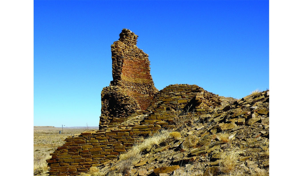
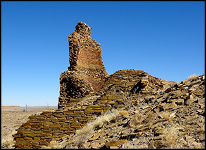
Figure 1. The tower kiva emanating above the unexcavated rubble mound of the Kin Ya'a great house. The finished masonry of each interior circular chamber is highlighted by the oxidised sandstone showing where the structure was burnt while still intact (photograph courtesy of Tom Vaughan/FeVa Fotos).
The unusual tower kiva structures that first emerge in Chaco Canyon and then spread into the Chaco World appear to be stacked kivas extending up to four storeys high, and are associated with monumental buildings known as ‘great houses’, which also feature conventional kivas of varying sizes. While archaeologists have gleaned much information on the function of subterranean kivas through ethnographic research on similar structures built by historic and modern Pueblo peoples, no contemporary examples of true tower kivas exist from which to gain an understanding of their purpose, and none have been excavated using modern archaeological techniques. Accordingly, even their presumed ceremonial role and relationship with subterranean kivas remain undemonstrated.
The vertical prominence of tower kivas has meant that interpretations formed from landscape archaeology, geographic information science (GISci), and other comparative research often focus on the long-distance visibility afforded by tower kivas (Hayes & Windes Reference Hayes, Windes and Frisbie1975; Kantner & Hobgood Reference Kantner, Hobgood, Forte, Williams and Wiseman2003; Robinson et al. Reference Robinson, Van Dyke and Windes2007). The semi-arid, sparsely vegetated landscape contributes to these interpretations, which variously see tower kivas as part of a regional communication system or as defensive towers. Another interpretation emphasises the possible role of tower kivas in Ancient Puebloan cosmology, proposing that they represent a new but perhaps short-lived belief system centred on the heavens and possibly future worlds (Fewkes Reference Fewkes1917: 14–15; Hewett Reference Hewett1936: 106; Van Dyke Reference Van Dyke2008). Neither perspective, however, has been systematically evaluated, nor need they necessarily be mutually exclusive.
In this article, we report the results of a GISci-based study of tower kiva viewsheds that builds upon earlier research by Kantner and Hobgood (Reference Kantner, Hobgood, Forte, Williams and Wiseman2003). While most viewshed research in the Southwest and elsewhere concentrates on the long-distance visibility of monumental built and natural features, our study instead suggests that tower kivas were constructed to enhance the visual status of great houses within the communities in which they were constructed. In addition to providing a specific interpretation of Ancient Puebloan tower kivas, this study offers a cautionary example illustrating that not all monumental built features are meant to contribute to regional landscapes, but may instead be part of local dynamics. At the same time, this study demonstrates that GISci methods can be used to draw these distinctions.
Research on tower kivas
Unlike their subterranean counterparts, tower kivas have received relatively little attention from archaeologists. Some debate has emphasised their definition because the great houses with which they are found are also associated with ‘blocked-in kivas’ and ‘elevated kivas’, neither of which, as with tower kivas, are subterranean, but are instead constructed within a roomblock (Lekson Reference Lekson1984: 52; Vivian Reference Vivian1990: 289). For this study, we define tower kivas as stacked circular rooms with at least one storey emanating above the structure on top of which they are built. Although the interior spaces of tower kivas are typically circular chambers, they are built into rectangular enclosures (Figure 1) to accommodate the rectilinear design of most Chaco-style great houses (see also Lekson Reference Lekson and Lekson2007: 21).
The earliest descriptions of tower kivas are from Chaco Canyon, where a concentration of monumental architecture suggests regional pre-eminence from approximately AD 900 into the early AD 1100s. Historically, the focus of archaeological investigation in Chaco Canyon has contributed to an assumption that tower kivas originated there, but tower kivas are also found elsewhere, including at Kin Klizhin just outside the canyon, and at Kin Ya'a (Figure 1), located 45km to the south. Complicating their interpretation is the fact that only three possible tower kivas have ever been excavated: Kiva N (also known as the West Tower Kiva) at Chetro Ketl (Hewett Reference Hewett1936: 101–106) and Kiva A at Kin Kletso (Vivian & Mathews Reference Vivian and Mathews1965: 44–45), both in Chaco Canyon, and the Salmon Ruins ‘tower kiva’ 70km north of the canyon, although this one post-dates Chaco by a century or more and may not have truly extended above the surrounding rooms (Vivian Reference Vivian1990: 303). Due to the fact that so few are excavated, dating of the tower kiva phenomenon is uncertain, with Lekson (Reference Lekson and Lekson2007: 21) arguing that it post-dates AD 1110, and others claiming a late eleventh-century emergence (Vivian & Mathews Reference Vivian and Mathews1965; Vivian & Hilpert Reference Vivian and Hilpert2002: 243).
Explanations for tower kiva function fall into two categories: utilitarian and ceremonial. A default explanation for towers of any sort is that they served defensive purposes, providing both a point from which to watch for approaching threats and a potential defensive stronghold (LeBlanc Reference LeBlanc1999: 226). Contributing to this interpretation are the excavations of the Salmon Ruins kiva, which revealed not only that this possible tower was set on fire in the AD 1270s, but that it contained the remains of numerous children and a few adults who perhaps died taking refuge there (LeBlanc Reference LeBlanc1999: 233). Although this conclusion has recently been challenged (Akins Reference Akins and Reed2008), and the Salmon Ruins kiva's status as a ‘tower’ kiva is uncertain, the use of tower kivas for defensive purposes remains a viable hypothesis.
Other explanations stress the potential use of tower kivas for communication (Vivian & Hilpert Reference Vivian and Hilpert2002: 243). There is some evidence that Ancestral Puebloan people may have constructed networks of signalling stations to facilitate regional communication (Ellis Reference Ellis, Duran and Kirkpatrick1991; Haas & Creamer Reference Haas and Creamer1993; Windes et al. Reference Windes, Anderson, Johnson, Ford, Kantner and Mahoney2000; Swanson Reference Swanson2003; Beers Reference Beers, Brown, Condie and Crotty2014). For example, experiments conducted in Chaco Canyon using hand-held flares demonstrated that enigmatic circular structures found on canyon rims were probably signal stations, each intervisible with its two nearest neighbours (Hayes & Windes Reference Hayes, Windes and Frisbie1975). This interpretation is consistent with evidence that many ancient societies around the world used signalling methods for long-range, rapid communication. In the US Southwest, historical evidence suggests that long-distance signalling was used for centuries. Spanish accounts, for example, discuss Contact-era indigenous populations in the Southwest using smoke fires to communicate over distances of up to 450km in two days (LeBlanc Reference LeBlanc1999; Beers Reference Beers, Brown, Condie and Crotty2014).
Other interpretations of tower kivas advocate phenomenological perspectives, arguing that the features augmented the monumentality and verticality of the great houses into which they were built, creating awe-inspiring spectacles (Van Dyke Reference Van Dyke2008). As such, perhaps tower kivas were intended more to be seen than to see from, and were symbolically tied into Puebloan belief systems and larger cosmographic landscapes that shaped daily human experience (Marshall et al. Reference Marshall, Stein, Loose and Novotny1979: 204; Sofaer et al. Reference Sofaer, Marshall, Sinclair and Aveni1989; Sofaer Reference Sofaer and Lekson2007). Similar explanations see tower kivas as symbols of power and authority meant to influence local sociopolitical dynamics within the communities where they were constructed (Fewkes Reference Fewkes1917: 35–36; Vivian & Mathews Reference Vivian and Mathews1965: 115; Van Dyke Reference Van Dyke2008).
Each of these perspectives makes assumptions about visibility, with explicit or implicit expectations of what could be seen from tower kivas, or, conversely, who could have seen them. It is difficult to evaluate these competing hypotheses because most tower kivas are no longer fully intact. Furthermore, modern alteration of the surrounding landscapes, as well as complicating factors such as decreasing air quality and light pollution, have also changed the modern viewsheds of tower kivas. For these reasons, this study intends to contribute to the discussion of tower kiva function through a GIS-based reconstruction of the ancient viewsheds from these once extant structures.
Viewshed analysis
Also referred to as visibility or intervisibility analysis, viewshed analysis is the process “whereby one defines the regions that are visible from a particular point in the terrain” (DeMers Reference DeMers2000: 283), and is one of the most promising areas in GISci for application on the tower kivas. As with so many other computer applications, viewshed analysis is becoming more powerful and user-friendly. Twenty-five years ago, the computation of a viewshed was considered to be a “complex calculation” (Star & Estes Reference Star and Estes1990: 164) that exceeded the capabilities of most desktop computers. Today, several GIS software packages are available that include powerful tools for viewshed analysis. As DeMers (Reference DeMers2000: 283) asserts, “any planning objective that requires anthropogenic features to be either visible or concealed will find utility in intervisibility analysis”.
Archaeological applications
In the past two decades, innovations in archaeological applications using GISci, combined with the development of GIS software that is cheaper and more user-friendly, have enhanced the archaeologist's ability to conduct spatial analyses. Archaeologists have used GISci in a variety of ways (Frieman & Gillings Reference Frieman and Gillings2007), ranging from the reconstruction of ancient road systems (Kantner Reference Kantner, Goodchild and Janelle2004) to “explorations of how prehistoric ritual landscapes might have been perceived by contemporary populations” (van Leusen Reference van Leusen, Barcelo, Briz and Vila1999: 219).
Viewshed analysis is a common tool in European archaeology, where its early use to identify the function of ancient structures and to reconstruct ancient landscapes has greatly influenced subsequent archaeological viewshed studies. For example, viewshed analysis was used to evaluate monumental architecture in the Wessex region of Great Britain in order to “obtain new insights into the ideological and cultural basis of the archaeological landscape” (Wheatley Reference Wheatley and Maschner1996: 99; see also Rennell Reference Rennell2012). Similarly, the approach was used in a study of Celtic roads and hillforts in Burgundy, France, to conclude that these towers served as signalling points (Madry & Crumley Reference Madry, Crumley, Allen, Green and Zubrow1990; Madry & Rakos Reference Madry, Rakos and Maschner1996). On the Croatian island of Hvar, viewshed analyses for the Greek period at Maslonovik demonstrated that a tower located in the town of Tor could have passed warnings between Maslonovik and the town of Pharos (Wheatley Reference Wheatley, Lock and Stancic1995; Gaffney et al. Reference Gaffney, Stancic, Watson, Aldenderfer and Maschner1996).
More recently, viewshed analysis in European archaeology has expanded from a focus on intervisibility to include studies of landscape perception by past peoples (e.g. Lake Reference Lake2007). A viewshed represents the area across which a location or monument may communicate visual information, and hence when multiple viewsheds overlap, they produce zones in which an observer can see many such locations, all of which may carry information regarding the perceived importance of particular spaces (Gaffney et al. Reference Gaffney, Stancic, Watson, Aldenderfer and Maschner1996; Garcia-Moreno Reference Garcia-Moreno2013). For example, Gillings (Reference Gillings2009) used viewshed analysis of megaliths on Alderney, the northernmost of the British Channel Islands, to demonstrate the importance of sea-view ‘visual affordances’ in the placement of these monumental features. Eve and Crema (Reference Eve and Crema2014) used a similar approach to show that Bronze Age settlements in Cornwall were situated so as to ensure intervisibility with ritual monuments, natural landmarks and tin-mining areas.
In the Americas, early archaeological GISci studies tended to revolve around predictive modelling over viewsheds and landscapes (e.g. Kvamme Reference Kvamme and Schiffer1989; Allen et al. Reference Allen, Green and Zubrow1990). This has changed over the past decade, especially in Central and South America. For example, Bongers and colleagues (Reference Bongers, Arkush and Harrower2012) used viewshed analysis to demonstrate that chullpas (funerary towers) in the Lake Titicaca region were deliberately placed to be highly visible in the landscape so as to maintain an enduring sociopolitical impact. From a somewhat different perspective, viewshed analyses by Doyle and colleagues (Reference Doyle, Garrison and Houston2012) suggested that one mechanism for Maya political control was visibility to and from probable paths of travel in the region. While North American archaeologists have made less use of viewshed analysis, this too is changing, as demonstrated by recent publications by Dungan (Reference Dungan2009) and Bernardini and colleagues (Bernardini et al. Reference Bernardini, Barnash, Kumler and Wong2013; Bernardini & Peeples Reference Bernardini and Peeples2015).
Possible shortcomings
While viewshed analysis has obvious strengths and is increasingly used by archaeologists, it is not without its shortcomings. Probably the most serious problem is that the precision of a computer-generated viewshed can disguise problems with accuracy. One of the main sources of error is the digital elevation model (DEM) used to simulate terrain. Problems with DEMs include: ‘sinks’, depressions that do not exist in the actual terrain; matching errors when DEMs do not seamlessly line up with one another; and edge effects that affect viewshed calculations (van Leusen Reference van Leusen, Barcelo, Briz and Vila1999; Hageman & Bennett Reference Hageman, Bennett, Westcott and Brandon2000; Doyle et al. Reference Doyle, Garrison and Houston2012). Newer generations of DEMs, such as the National Elevation Dataset (NED), have mitigated, if not entirely eliminated, many of these problems.
Another issue has been a tendency to ignore the impact of diminishing visibility over distance. For example, a GIS-generated viewshed can include areas hundreds of miles away, well beyond normal human sight (Wheatley & Gillings Reference Wheatley, Gillings and Lock2000; Ogburn Reference Ogburn2006). Many factors can degrade visibility however, including the earth's curvature, the time of day, the time of year, atmospheric conditions, the ocular health of the viewer, and how distinguishable objects are from the surrounding landscape. Fortunately, these issues can be addressed with the construction of “fuzzy viewsheds” (Ogburn Reference Ogburn2006: 408) and the use of distance-decay functions that “simulate the loss of visual resolution with distance” (van Leusen Reference van Leusen, Barcelo, Briz and Vila1999: 221).
Arguably, the most significant challenge with the use of viewshed analysis for reconstructing past landscapes is the degree to which empirical assessments of intervisibility can be reasonably assumed to correlate with actual human visual experience. With the advent of GIS-based viewshed analysis, a running debate continues between advocates for the empirical sufficiency of GISci methods and those who argue for a more phenomenological approach to landscape (e.g. Thomas Reference Thomas, Thomas and Jorge2008). In an excellent discussion of this debate, Rennell (Reference Rennell2012: 511–12) characterises these positions as “subject-centered survey” vs “GIS as experiential archaeology”, and attempts to find common ground between the two in her study of monumental features on the Outer Hebrides islands off Scotland (see also Kosiba & Bauer Reference Kosiba and Bauer2013). A similarly nuanced approach is provided by Llobera (Reference Llobera2003, Reference Llobera2007), who uses the concepts of visual affordance and visualscapes as necessary considerations for reconstructing past human landscapes.
Many of these changes over the past decade in how GIS-based viewshed analysis is applied to archaeological problems are reflected in our viewshed analyses of Chaco-era tower kivas. Our earlier study (Kantner & Hobgood Reference Kantner, Hobgood, Forte, Williams and Wiseman2003) used the technology and spatial datasets available at the turn of the millennium, and concentrated on empirically oriented viewshed analysis rather than on the subject experience. Ten years later, with improved spatial data and a wealth of new viewshed studies to inform us, we can re-examine our earlier assessments and develop more complete conclusions about the role of tower kivas in the eleventh-century AD Puebloan landscape.
Viewshed analysis of tower kivas
To assess hypotheses for the function of Chaco-era tower kivas in the US Southwest, a 2500km2 study area approximately 30km to the south of Chaco Canyon was selected for a GIS-based viewshed analysis (Figure 2). The study area is considerably smaller than the Chaco World—the term used to describe the approximately 250 000km2 region influenced by Chaco Canyon—but it has been extensively studied over the past two decades by author JK and contains a representative sample of Ancient Puebloan communities, great houses and kivas, all within a topographically diverse landscape. It also contains two tower kivas, one at the Kin Ya'a great house, and the other at the Haystack great house, approximately 45km from one another (Figure 2). A GIS database assembled by author JK contains environmental and cultural spatial data, including information on over 2000 archaeological sites, further making the study area an excellent location for evaluating tower kiva function.

Figure 2. Map of study area in north-western New Mexico, USA, showing the terrain, prominent topographical features and Kin Ya'a and Haystack tower kiva locations.
Methods
Before generating viewsheds for the two tower kivas in the study area, a digital terrain surface was constructed. Unlike a pilot project conducted earlier and reported in Kantner and Hobgood (Reference Kantner, Hobgood, Forte, Williams and Wiseman2003), which used 7.5-minute US Geological Survey DEMs with 30m resolutions, the digital surface for the current project was generated from a 10m-resolution seamless NED model produced by the University of New Mexico's Resource Geographic Information System Program (Figure 2). Although experiments were done using a triangulated irregular network (TIN) for creating viewsheds, DEM-based raster surfaces were considered more effective. While the utility of TIN vs DEM/NED surfaces is debatable (Llobera Reference Llobera2003, Reference Llobera2007), the latter is generally preferable as long as sufficient computing power is available to handle the memory needs of a DEM, and if the DEM's resolution captures the meaningful spatial variability of the actual terrain.
Analyses were conducted using the viewshed tools in ArcGIS 10 Spatial Analyst. Viewshed simulations accounted for the curvature of the earth, which is a quadratic function of distance. Perhaps more importantly, viewsheds were limited to a distance of 20km because the combination of the earth's curvature with natural limitations of visual acuity would have made it highly unlikely that an architectural feature measuring less than 20m in height and 10m in width could be discerned at any greater distance (Wheatley & Gillings Reference Wheatley, Gillings and Lock2000: 15–16; Ogburn Reference Ogburn2006: 406). Additionally, viewsheds of 20km were more than adequate for including all relevant cultural features for testing the hypotheses of tower kiva function, as outlined below.
Results
The analyses first examined intervisibility between Haystack and Kin Ya'a to test the hypothesis that the tower kivas were constructed to facilitate the operation of a system of communication. Viewsheds were generated that modelled what was visible from ground level (1.7m, the average viewing height of a standing person) and the level of the tower (13.7m, based on the estimated original height of the Kin Ya'a tower plus the 1.7m viewing height of a person standing at the top). In the earlier analyses reported in Kantner and Hobgood (Reference Kantner, Hobgood, Forte, Williams and Wiseman2003), and described above as using lower-resolution DEMs, the tower kivas were demonstrated to not be intervisible with one another, which is unsurprising considering the elevations of the intervening Dutton Plateau. The earlier project did identify areas where the two viewsheds overlapped (Kantner & Hobgood Reference Kantner, Hobgood, Forte, Williams and Wiseman2003: fig. 10), and hypothesised that these locations accommodated signal relay stations between Kin Ya'a and Haystack. Further investigations of these areas, however, failed to identify archaeological remains.
The current re-analyses demonstrate why no relay stations were found. Using the higher-resolution NED data, and taking into account visual acuity and especially the earth's curvature, the updated viewsheds identify no areas of overlap at all (Figure 3). In other words, locations for possible signal-relay stations could not have existed unless multiple such stations were strung together across the Dutton Plateau. As with the earlier study, albeit perhaps for the correct reasons this time, the new analyses confirm that the Kin Ya'a and Haystack tower kivas were not constructed to contribute to a regional communication system.
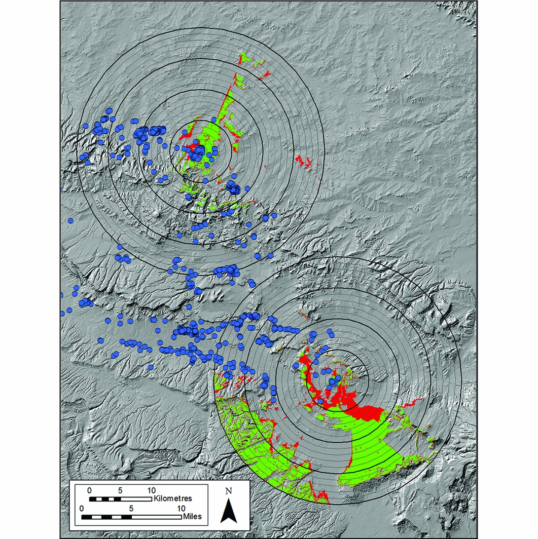
Figure 3. Viewsheds of each tower kiva using high-resolution NED data. Light concentric rings around each tower kiva are shown at every 1km from each tower kiva, with darker rings indicating 5km intervals. Colour-tinted terrain indicates the increase in viewshed area (red) from the top of the tower kiva compared with the ground-level viewshed from that same location (green). Locations of Puebloan archaeological sites are identified by blue dots.
The next stage of the study assessed the hypothesis that tower kivas were constructed for defensive purposes, specifically to monitor the approach of danger. Multiple viewsheds were created at different tower heights in an attempt to determine the degree to which tower heights contributed to long-distance visibility. Sets of five viewsheds were generated for both Kin Ya'a and Haystack, starting with someone with an eye height of 1.7m standing on the ground and with subsequent viewsheds adding 2m in viewer height each time (Figure 4). The last viewshed modelled the view from someone standing on a 16m-high tower; even though tower kivas are believed to have been approximately 12m high, viewsheds for towers taller than this were generated to determine the potential for increased view. Each viewshed was segmented into 5km zones to determine how the visibility of increasingly distant areas from the tower kivas was enhanced by increasing tower height.
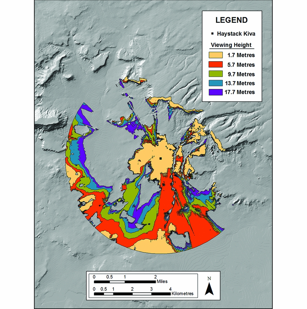
Figure 4. Map demonstrating increasing visibility within 5km of a tower kiva as a result of increasing height. The Haystack tower kiva is used here as an example. All other figures assume a tower height of 12m and a viewer with an eye height of 1.7m.
The results of this stage of the study reveal that after 5km in distance from the tower kivas, there is a diminishing return in the relationship between visibility and tower height (Figures 5 & 6). In other words, as the tower height increases, the area visible outside of a 5km radius does not appreciably increase. To assess this thoroughly, a more precise measure of the relationship between tower height and distance visibility was conducted. This was accomplished by generating buffers around the kivas at 1km increments for 20km (Figure 3). The viewshed within each of these bands was measured with and without the addition of a tower. The results demonstrate that at greater distances from the tower kivas, there is little advantage to having a height of 12km regarding overall distance visibility; by 7km away from the Kin Ya'a tower kiva and 9 km from the Haystack tower kiva, any increase in visibility afforded by a tower is negligible (Figures 7 & 8).
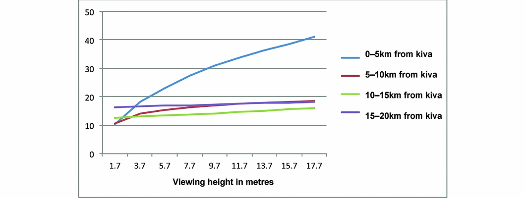
Figure 5. Graph showing the percentage of ground surface visible at varying distances from Haystack tower kiva as height increases.
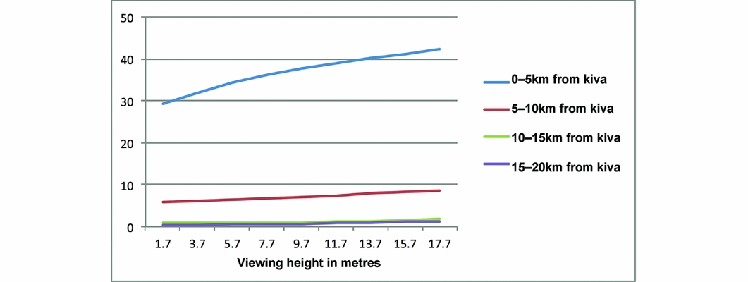
Figure 6. Graph showing the percentage of ground surface visible at varying distances from Kin Ya'a tower kiva as height increases.
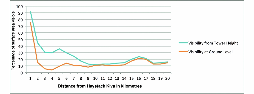
Figure 7. Graph showing the percentage of surface area visible from ground level vs 12m height at increasing distance from the Haystack tower kiva.
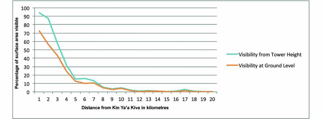
Figure 8. Graph showing the percentage of surface area visible from ground level vs 12m height at increasing distance from the Kin Ya'a tower kiva.
Finally, the visibility towards, rather than from, tower kivas was assessed to determine whether they had greater importance within the immediate area. For this analysis, instead of looking at the amount of space within each viewshed, the number of known archaeological sites therein was calculated. Given that each recorded site in the study area is a separate residential structure, this analysis provides insight into the extent to which tower kivas were meant to be part of the daily visual experience of Ancient Puebloan peoples living in the immediate area. This analysis reveals that 34 per cent more sites located up to 5km from Kin Ya'a could see the great house complex when enhanced with a tower kiva, compared with the complex's visibility without it (Figure 9). In contrast, between 5 and 20km from Kin Ya'a, the tower kiva provided intervisibility with only one more site than could be seen from the ground, even though the total number of sites increased by 683 over this distance. Analysing the intervisibility of recorded archaeological sites with the Haystack tower kiva produced similar results: in the area up to 5km from Haystack, an additional 12.5 per cent of sites could see the great house complex when the tower kiva was added to it, while only 2.5 per cent more sites located 5–20 km from Haystack could see the great house complex with the addition of the tower kiva (Figure 10).
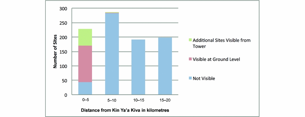
Figure 9. Graph showing the number of Ancient Puebloan households within each 5km segment from the Kin Ya'a tower kiva, divided into those visible from the ground, those visible from a 12m height and those not visible from either height.
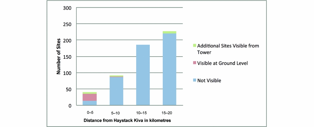
Figure 10. Graph showing the number of Ancient Puebloan households within each 5km segment from the Haystack tower kiva, divided into those visible from the ground, those visible from a 12m height and those not visible from either height.
Conclusion
The results of the viewshed analysis of the Kin Ya'a and Haystack sites demonstrate that eleventh-century AD tower kivas in the Chaco World were unlikely to have been built to see or be seen over long distances. The rapid decrease in visible area as distance from each tower kiva increases suggests that defence was not a primary function, a conclusion consistent with other evidence for generally decreased levels of violence during the Chaco era (LeBlanc Reference LeBlanc1999; Lekson Reference Lekson2002; Kohler & Kramer Turner Reference Kohler and Kramer Turner2006). The scattered distribution of small households that characterise the Chaco era, for example, is replaced by aggregated multi-family buildings during later periods that are characterised by clear evidence for violent raiding (Kantner Reference Kantner1999; Kuckelman et al. Reference Kuckelman, Lightfoot and Martin2002).
The lack of intervisibility between the Kin Ya'a and Haystack tower kivas also suggests that these architectural features were not designed as part of a regional communication network. While the Dutton Plateau makes direct visibility from one tower kiva to the other impossible, the viewshed analysis further suggests that no stations were established to relay signals across this topographic obstacle, insofar as the two viewsheds show no overlap. Although the two tower kivas may have been used for signalling within local sub-regions, or may have served as termini within larger communication networks, the evidence that the height of the tower kivas adds little to their visibility beyond the immediate area of their situation again indicates that regional signalling was not a primary function.
In contrast, the viewshed analysis demonstrates that the height of the tower kivas did greatly enhance intervisibility with nearby households. In fact, each tower kiva viewshed includes most of the domestic structures considered to be part of the surrounding community (Figure 3). While the distribution of households in the Haystack community is not as well known due to uneven archaeological investigation, the tower kiva viewshed clearly covers much more of the local area than can be seen from ground level. In the case of Kin Ya'a, 22 of the 102 households considered part of the surrounding community are not visible from the ground level, but are part of the tower kiva viewshed. Importantly, these households were situated so as to be able to see the tower kiva, whereas few households were built in the blind spots from which the tower was not visible.
The results of this study indicate that tower kivas served to enhance the monumentality and visibility of the great houses above which they were built, with the intended audience including members of, and visitors to, the immediate community. They probably provided an important gravitational locus around which communities evolved. In many ways, tower kivas functioned much like church steeples or mosque minarets. Steeples and spires, for example, have a complex history originating in Classical antiquity, but are generally seen as combining political, religious and symbolic functions to enhance the monumentality of church architecture (Bork Reference Bork2003). Similarly, the history of the minaret suggests that its role as a symbol of Islam developed around its function as a visible beacon drawing people to mosques (Bloom Reference Bloom1989). This study suggests that tower kivas similarly helped to define the great house as the social and political centre of the communities in which they were built, even while no doubt possessing their own symbolism related to the religious architecture of which they were a part.


 Open access