


Introduction
The present-day ice sheets in Greenland and Antarctica are known to be polythermal and rest on beds that are partly frozen and partly thawed (Reference PatersonPaterson, 1994; Reference HuybrechtsHuybrechts, 1996; Naslund and others, submitted). The bed conditions under the central parts of the Fennoscandian and Laurentide palaeo-ice sheets have, however, remained elusive. It is now gradually becoming recognized that the glaciallineation record, which dominates ice-sheet scale glacial geological and geo- morphological maps (Reference Prest, Grant and RamptonPrest and others, 1968; Reference Kleman and StroevenKleman and others, 1997), may be the cumulative result of the landform production of ice sheets that, at any given moment, were thawed over only a part of their area. A growing body of work points to former frozen-bed conditions as the most likely candidate for preservation of relict glacial and non-glacial land- forms and landscapes found in enclaves surrounded by young (last deglaciation) landscapes (Reference KujansuuKujansuu, 1975; Reference Dyke and MorrisDyke and Morris, 1988; Reference LagerbäckLagerbäck, 1988a, Reference Lagerbäckb; Reference Lagerbäck and RobertssonLagerbäck and Roberts-son, 1988; Reference RodheRodhe, 1988; Reference Sollid and SørbelSollid and Sørbel, 1988; Reference Kleman and BorgströmKleman and Borgström, 1990, 1994; Reference Dyke, Morris, Green and EnglandDyke and others, 1992; Reference KlemanKleman, 1992; Reference HättestrandHättestrand, 1997, Reference Hättestrand1998).
The factors controlling the location ofthe various thermal zones are reasonably well understood in glaciological terms (Reference HookeHooke, 1977; Reference Hughes, Denton and HughesHughes, 1981), but only small parts of the former ice-sheet beds of the Northern Hemisphere have been analyzed in this context, and only in a few areas (Reference KlemanKleman, 1992; Reference DykeDyke, 1993; Reference GlasserGlasser, 1995) have efforts to discern the factors controlling the layout of frozen/thawed-bed patchworks been made. With a developed understanding of the factors governing such patterns, extrapolation to less-known regions can be made and the problem of basal thermal zonation on ice-sheet scale successfully approached. There is an increasing need to interpret the geological and geomorphological record of former ice-sheet beds in terms of basal thermal zonation, because current numerical ice-sheet models include thermal calculations and predictions (Reference Huybrechts and T’siobbelHuybrechts and T’siobbel, 1995; Reference Payne and ongelmansPayne and Dongelmans, 1997). Palaeo-ice thickness and volume estimates depend strongly on the assumed or modelled subglacial and englacial temperatures. Ideally, such models should be validated with some direct record of subglacial palaeotem-peratures. However, no such record is known, leaving only the landform record which is assumed to result from fundamental differences in the magnitude of substratum reshaping between thawed-bed areas and frozen-bed areas.
Frozen/thawed-bed boundaries represent important discontinuities in the glacial system and the spatial pattern and stability of these boundaries is therefore an important question. Through work on West Antarctic ice streams (Reference Shabtaie and BentleyShabtaie and Bentley, 1987), sharp flow-parallel boundaries are known and palaeo-boundaries of that type have also been documented from the Laurentide and Fennoscandian areas (Reference Dyke and MorrisDyke and Morris, 1988; Reference KlemanKleman, 1992). Less has been known about boundary patterns in sheet-flow areas. Reference Hughes, Denton and HughesHughes (1981) depicted the transition between a frozen-bed core area and an outer wet-bed zone as a mosaic of frozen-bed “islands” fully enclosed by surrounding wet-bed areas.
The often subtle differences between relict landscapes marking frozen-bed patches and wet-bed landscapes are typically obscured in forested terrain, or have been degraded by Holocene active-layer processes in permafrost regions. Detailed (local-scale) evidence is best preserved on treeless, relatively dry uplands with coarse-grained soils, making much of northern and western Scandinavia a highly suitable area for study of such former bed patterns. In this paper, we explore the bed-condition evidence in the Fennoscandian ice sheet area. We present nested maps at four spatial scales and discuss the factors governing basal temperature at the ice-sheet scale, the mesoscale, the regional scale, and the local scale.
Landform Assemblages Marking Former Frozen-Bed Conditions
There are abundant descriptions of pre-late Weichselian landforms that have survived morphologically unaltered in west-central and northern Fennoscandia (Reference KujansuuKujansuu, 1975; Reference LagerbäckLagerbäck, 1988a, Reference Lagerbäckb; Reference Lagerbäck and RobertssonLagerbäck and Robertsson, 1988; Reference RodheRodhe, 1988; Reference Sollid and SørbelSollid and Sørbel, 1988; Reference Kleman and BorgströmKleman and Borgström, 1990, 1994; Reference KlemanKleman, 1992; Reference Johansson and KujansuuJohansson and Kujansuu, 1995; Reference HättestrandHättestrand, 1997; Reference Kleman and StroevenKleman and Stroeven, 1997; Reference Clarhäll and KlemanClarhall and Kleman, 1999). These accounts suggest that parts of the ice- sheet bed experienced no erosional impact at all during one complete ice-sheet cycle, with a probable duration of around 50 000 years (Reference Kleman and StroevenKleman and others, 1997). In most cases, frozen- bed conditions lasting the entire duration of the last ice sheet have been invoked as the probable cause of preservation. The implicit assumption is that wet-bed conditions, even if they prevailed only briefly, would have been associated with basal sliding and the destruction of delicate pre-existing morphology, such as patterned ground (Reference Kleman and BorgströmKleman and Borgström, 1994) or sharp-crested esker ridges (Reference Lagerbäck and RobertssonLagerbäck and Robertsson, 1988). Most important, these relict landforms and landscapes are fragmented, i.e. intervening areas display conventional glacial landform assemblages of drumlins, eskers and striated bedrock of, mostly, late-glacial age. This distinct “patchiness” exists both on the local scale (Reference Kleman and BorgströmKleman and Borgström, 1994) and the regional scale (Reference LagerbäckLagerbäck, 1988a; Reference HättestrandHättestrand, 1997). On the local scale, the two landscape types are often separated by exceedingly sharp boundaries (<50 m), separating sliding zones from relict surfaces, and specific subglacial boundary forms often occur (Reference Kleman and BorgströmKleman and Borgström, 1990). We consider frozen-bed conditions as the only reasonable explanation for the preservation of intact pre-last ice-sheet ground surfaces and therefore rely on this assumption in this paper.
Morphological Method
In order to distinguish dry-bed/wet-bed patterns, we rely on landforms and surfaces demonstrably older than the last ice sheet. This is reasonably straightforward when the preservation of surfaces and landforms developed under subaerial conditions is used as an indicator of subsequent frozen-bed conditions, because these features can neither survive or form under wet-bed subglacial conditions. It is far more difficult to trace frozen-bed patches that existed on older glacial surfaces with abundant lineations and other sliding traces. It can only be done in favourable circumstances, with the best possibilities afforded by mosaic landscapes where the flow traces from different glacial events differ widely in direction. An excellent example of such analysis is presented in Reference Dyke, Morris, Green and EnglandDyke and others (1992).
Owing to the cumulative nature of subglacial reshaping, estimates of the extent of frozen-bed conditions are minimum estimates. Even if, at any given moment, only a tiny fraction of the bed is thawed, a change in location of these patches can theoretically consume entirely any frozen-bed marker surface. Hence, our maps portraying the spatial arrangement of frozen-bed patches systematically overestimate the fraction of sliding bed at any given time, and will show the sliding fraction of bed integrated over some period. Nevertheless, important inferences about basal thermal patterns and factors controlling the location of wet-bed and frozen-bed zones can be made from those maps.
Results: Distribution of Relict Landscapes and Inferred Basal Thermal Patterns
Ice-sheet scale
On the ice-sheet scale, a picture of the overall distribution of the relict landscapes marking frozen-bed conditions under the late Weichselian ice sheet has emerged during the last decade (Reference Sollid and SørbelSollid and Sørbel, 1988; Reference Kleman and StroevenKleman and others, 1997). The most important relict landforms are: (1) the Veiki moraine, created by supraglacial and ice-marginal processes by an early Weichselian ice sheet (Reference LagerbäckLagerbäck, 1988a; Reference HättestrandHättestrand, 1998). These moraines are partly covered by in-situ organic sediments yielding non-finite radiocarbon ages. The moraine plateaux were already observed by Reference HoppeHoppe (1952) to be drumlinized from the southwest, but were at that time thought to have formed subglacially under the same ice sheet that drumlinized them; (2) till-covered, but morphologically little-affected early Weichselian eskers (Reference KujansuuKujansuu, 1975; Reference Lagerbäck and RobertssonLagerbäck and Robertsson, 1988); (3) marginal channels and lateral moraines (Reference RodheRodhe, 1988; Reference KlemanKleman, 1992; Reference HättestrandHättestrand, 1998) that are partially degraded and incompatible with the late Weichselian retreat pattern; and (4) areas with regolith and/or patterned ground of pre-late Weichselian age (Reference Kleman and BorgströmKleman and Borgström, 1990; Reference Niemelä, Ekman and LukashovNiemelä and others, 1993). In Figure 1, black colour shows areas thought not to have experienced wet-based conditions for any geomorphologically significant length of time during the late Weichselian. In these areas, the basic morphology of older glacial or non-glacial landforms is preserved, although a weak, mostly deglacial, fluting occasionally occurs. On topographic highs, preservation is often complete, with ground surfaces from older ice-free periods having experienced neither erosion nor deposition for the duration of the last glacial event (Reference Clarhäll and KlemanClarhall and Kleman, 1999).The relict surfaces are common between the Last Glacial Maximum (LGM) ice divide and the elevation axis of the Scandinavian mountain range (Fig. 2), with abundance and continuity increasing northeastwards. Within high- to medium-relief terrain, the relict surfaces mainly occur on topographic highs, but north and east of the Gulf of Bothnia, relict landforms are found down to sea level. The areas with light shading in Figure 1 show the inferred minimum extent of frozen-bed areas during the LGM, based on the distribution of ribbed moraine (Reference Hättestrand, Goodwillie and KlemanHättestrand and Kleman, 1999) which we consider to have formed during transition from a frozen to a thawed bed. Intermediate shading shows the inferred extent of frozen-bed conditions for the Younger Dryas stage (12 kyr BP), when headward propagation of ice streams in Finland had started.
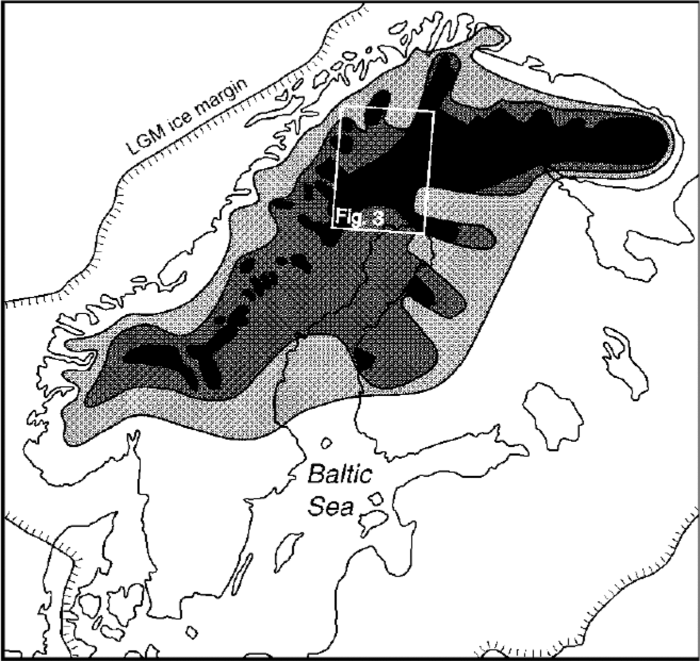
Fig. 1. Ice-sheet scale distribution of relict landscapes reflecting frozen-bed conditions (black areas). These areas are interpreted not to have experienced wet-based conditions for any significant length of time during the late Weichselian. The areas with light shading show the inferred minimum extent of frozen-bed areas during the LGM, based on the distribution of ribbed moraines (Reference Hättestrand, Goodwillie and KlemanHättestrand and Kleman, 1999) which we consider to have formed during conversion from a frozen to a thawed bed. Intermediate shading shows the inferred extent of frozen bed for the Younger Dryas stage (12 kyr BP), when ice streams in Finland had developed.

Fig. 2. The LGM ice-sheet configuration in Fennoscandia (slightly modified from Reference Kleman and StroevenKleman and others (1997)) and the outline of the Scandinavian mountain range.
Mesoscale: northern Sweden
Figure 3 shows a sector of northern Fennoscandia that generally experienced divergent flow during the final stages of the last deglaciation. The main features are a large central area with relict landforms, and areas to the north and south with abundant late Weichselian deglacial landforms. From the east, the proximal part of the Rovaniemi ice stream corridor, of approximately Younger Dryas age, cuts into the preserved area. The Kiruna lineation and esker swarm, that can be traced from the northern Norwegian coast and southwest- wards over Kiruna, is problematic. In contrast to typical palaeo-ice-stream corridors, a clear convergence-divergence pattern is lacking and deglacial meltwater traces (eskers and meltwater channels) are aligned to flow traces for the entire length of the lineation swarm. We suggest the Kiruna swarm was not an ice stream in the glaciological sense, but instead formed incrementally during deglaciation in a sector of the ice margin where the wet-bed zone reached further up-glacier than in adjacent areas. The smaller areas, with relict landforms in the northwestern part of the map, are located on topographic highs. Topography cannot, however, explain the location of the main preserved area, which is located where the deglacial ice flow was strongly divergent (Fig. 4).

Fig. 3. Mesoscale distribution of relict landscapes reflecting frozen-bed conditions (shaded areas). These areas display an abundance of Early Weichselian glacial landforms (Lager-bäck, 1988b; Reference HättestrandHättstrand, 1998), in many cases with superimposed organic sediments of interstadial age (Reference LagerbäckLagerbäck, 1988b; Reference Lagerbäck and RobertssonLagerbäck and Robertsson, 1988).

Fig. 4. The deglaciation pattern in northern Sweden and Finland. Ages are in calendar years. Chronology is from Kleman and Stromberg (in press). Grey tone shows zone of divergent ice flow in northern Sweden.
Regional scale
Figure 5 shows relict surfaces in a 40 × 65 km area in hilly terrain at the eastern boundary of the mountain range. The gross morphology of the area is essentially non-glacial, with rounded summits, gentle slopes and few lakes outside the main valleys (Reference Kleman and StroevenKleman and Stroeven, 1997). Fluting and occasional minor drumlins form a coherent, strongly bending swarm indicating ice flow towards the northeast. We assign this fluting to the late stages of deglaciation because its pattern closely mimics the pattern of lateral meltwater channels in the area. The flow pattern is incompatible with the southeast-to-northwest flow that is inferred to have existed in the region during the LGM. Relict surfaces showing no evidence of deglacial fluting occur on most hills reaching over 800 m. Lee-side scarps (Reference Kleman and BorgströmKleman and Borgstrom, 1994; Reference Clarhäll and KlemanClarhall and Kleman, 1999), which separate undisturbed regolith or old till covers at the summits from bare bedrock and fluted terrain, occur at the distal boundary of a majority of the relict surfaces. A most striking feature of the map is the extremely strong topographic control, with relict surfaces only occurring over a plane dipping very gently in the up-ice direction. We interpret the fluting to have formed in a narrow inward-transgressive marginal zone during final deglaciation, and consider the archipelago-like pattern of relict surfaces to form a snapshot of the location of frozen-bed areas during the last deglaciation.

Fig. 5. Regional-scale patterns of relict surfaces marking frozen-bed conditions. The figure shows relict surfaces in a 40 × 65 km area in hilly terrain at the eastern boundary of the mountain range. Fluting and occasional minor drumlins form a coherent, strongly bending swarm indicating ice flow towards the northeast. We assign this fluting to late stages of deglaciation, because its pattern closely mimics the pattern of lateral meltwater channels in the area and forms a natural proximal extension to the eskers found further to the northeast. Relict surfaces showing no evidence of deglacial fluting occur on most hills reaching over 800 m a.s.l., with an archipelago- type transition to the completely fluted areas to the east.
Local scale
Figure 6 shows part of the hilly area covered in Figure 5 in greater detail. In addition to lee-side scarps, two other types of boundary landforms are shown. Stoss-side moraines (Reference Kleman and BorgströmKleman and Borgström, 1994) appear to mark inhibited transport of subglacial material into frozen patches on hill summits. The alternative explanation, that these moraines formed as conventional marginal moraines, appears less likely because no such moraines were found on otherwise similar hills that were fluted and eroded by the last ice sheet. We noted that the drift cover is occasionally unusually thick on the proximal side of the relict surfaces, marking frozen patches (dark shading in Fig. 6), although the distinctive stoss-side moraine morphology is lacking.

Fig. 6. Local-scale patterns of relict surfaces marking frozen- bed conditions. The figure shows part of the hilly area covered in Figure 5 in greater detail. Topographical control on the location of frozen patches is very strong also at this scale, but the boundaries are irregular The distal boundaries of frozen patches are typically located higher than the proximal boundaries and often at along-flow knickpoints in the hill profiles.
Topographical control on the location of frozen patches is very strong also at this scale level, but the boundaries are irregular. An interesting feature is that the distal boundaries, often marked by lee-side scarps, are typically located higher than the proximal boundaries, and are also often located at along-flow knickpoints in the hill profiles.
Discussion and Conclusions
Subglacial landforms cannot be dated directly. However, some temporal information can be gained through relating the direction of flow traces to the dispersal-centre shifts that occurred through the post-maximum stages of the late Weichselian ice sheet (Reference Kleman and StroevenKleman and others, 1997), and from the ice-marginal moraines left by the major ice streams in Finland (Reference PunkariPunkari, 1989) for which chronological constraints exist. In almost all areas we have investigated, the partial erasure and destruction of older landforms was caused by ice flow that, through its directional pattern, can be linked to the decay phase and in most cases post-Younger Dryas time (after 12kyrBP). The presence of ubiquitous early Weichselian landforms, but a complete lack of flow traces from the east (reflecting the Bothnian Bay-centred LGM dispersal centre), suggests that northern Sweden had a fully frozen bed throughout the LGM and temporally adjacent phases. We believe that a marginal wet-bed zone transgressed inward around most of the perimeter of the ice sheet during deglaciation. On topographic highs or where flow was strongly divergent, this marginal zone was very narrow or nonexistent. In lower parts of the terrain, or where ice flow was parallel or convergent, the wet-bed zone was wider and created a classical deglacial landform assemblage usually lacking relict elements. Only large pre-existing landforms, such as very large crag-and-tails (Reference Hättestrand, Goodwillie and KlemanHättestrand and others, 1999), survived in those areas. In hilly terrain, the archipelago-type boundaries between frozen and thawed bed developed, shown in Figures 5 and 6.
The role of ice streams
In Figure 1, it is evident that ribbon-like indentations in the frozen-bed area were caused by the headward propagation of ice streams that developed in Finland at approximately Younger-Dryas time. These probably indicate short-lived rapid flow, which was terminated well before the retreating ice margin had reached its proximal parts. In contrast to the clear terrestrial record, conditions in the Baltic and Bothnian basins, with topography and substratum conditions favourable for ice stream development, are poorly known. It is likely ice streams developed there, but we cannot pinpoint their exact location.
We have found evidence for three distinct types of frozen/thawed-bed boundaries (Fig. 7); (1) true ice-stream corridors cutting into frozen-bed areas. Rapid flow had shut down well before final deglaciation; (2) wet-bed zone embayments, which in the geomorphological record are seen as a well-delineated zones of intense lineation development, but lacking the convergence—divergence pattern of the true ice-stream corridors. They probably represent the inward transgression of a marginal wet-bed zone reaching deeper in the up-glacier direction than in surrounding areas; and (3) “archipelago-type” boundaries in hilly areas that experienced sheet flow.
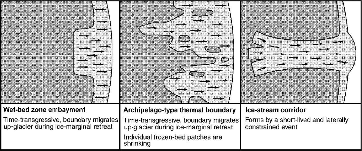
Fig. 7. Three distinct types of frozen/thawed-bed boundaries. Dark grey shows frozen-bed areas, and light grey shows wet-bed areas.
Factors controlling location of frozen-bed zones
At the ice-sheet scale, the relict surfaces are most abundant between the easterly maximum-stage ice divide and the elevation axis of the mountain range. The location of frozen- bed zones was mainly a function of dispersal-centre location, (low surface temperatures and small strain heating) and small ice thickness over the eastern flank of the mountain range. At the mesoscale (260 × 360 km map area), the pattern of relict surfaces is governed by inward-cutting ice-stream erosion. Topographical control on the basal thermal zonation was weak, but relation to flow pattern strong, with major frozen-bed zones located where ice flow was strongly divergent. At the regional scale (40 × 65 km map area), in hilly terrain, topographical control was strong, with relict surfaces only appearing over a plane dipping in the up-ice direction. At the local scale (12 × 14 km map area), overall control by topography was likewise strong, but the detailed boundary pattern irregular.
Acknowledgements
This work was funded by a grant from the Swedish Natural Science Research Council to J. K. We want to thank M. R.Bennett and an anonymous referee for constructive comments on the manuscript.


