


Introduction
An explosive volcanic eruption illustrates the dynamic nature of Earth. Major volcanic eruptions, such as those of Laki in AD 1783 at high latitude (64° N) andTambora in AD 1815 near the Equator (8° S), deposit large amounts of strong acids on a global or hemispheric scale, making it possible to detect volcanic acid horizons in polar ice (Reference Clausen and HammerClausen and others, 1988). Ice-core records from both polar regions provide one of the best means available for determining the potential atmospheric impact and global significance of these explosive volcanic eruptions. For example, volcanic events recorded in Greenland ice-core sulfate series correlate with annual changes in atmospheric temperature, exhibiting evidence for sulfate aerosol shielding (Reference Lyons, Mayewski, Spencer, Twickler and GraedelLyons and others, 1990; Reference Stuiver, Grootes and BraziunasStuiver and others, 1995; Reference White, White, Steig and BarlowWhite and others, 1997) and providing the most reliable means for evaluating past variability within the volcanic-climate system. However, to understand the global volcanic-climate system by means of polar ice-core study, it is essential to identify historic volcanic events in the polar regions, in addition to the major eruptions around the world. It is suggested, first of all, that the eruption sequence for the volcanoes active at present and those having historical eruption records should be reconstructed, even if some of them are only of focal significance. Several polar ice cores, for example from Byrd station, West Antarctica (Reference Gow and WilliamsonGow and Williamson, 1971; Reference Kyle and JezekKyle and Jezek, 1978), have shown that some historical eruptions were recorded in polar ice in the form of ash layers owing to the relative proximity of the core site to the volcano (es). These ice cores probably contain the most complete record of the history and products of the eruptions.
InWest Antarctica, six zones with active volcanisms since the Pleistocene have been recognized (Reference González-FerranGonzález-Ferran, 1991). The Bransfield Rift, where the South Shetland Islands (SSI; Fig. 1) are located, experienced the most recent eruptions in 1967,1969 and 1970 on Deception Island (Reference González-FerranGonzález-Ferran, 1991). Reference Dahe, Zielinski and GermaniQin and others (1994) reported the discovery, in the ice cores recovered from Nelson Island, of a tephra layer that appears to be from the 1970 Deception Island eruption. Reference OrheimOrheim (1972) suggested, based on the measurement of seasonal wind-blown dust layers in the glacial ice at Deception Island, that there was a series of eruptions during the period 1912-17. Among the earliest accounts of volcanic activity on the SSI was Reference WilkersWilkers’ (1845) description of the 1842 eruption at Deception Island. Earlier eruptions, including the events at Deception Island and Penguin Island (near King George Island, SSI), are presented in Reference Simkin and SiebertSimkin and Siebert (1994). But some of these events need to be confirmed or corrected because of their uncertain data origin. For instance, of the ten volcanic events listed above extending back from AD 1956 to 1800, four are questionable for Deception Island, as are two of the Penguin Island eruptions.
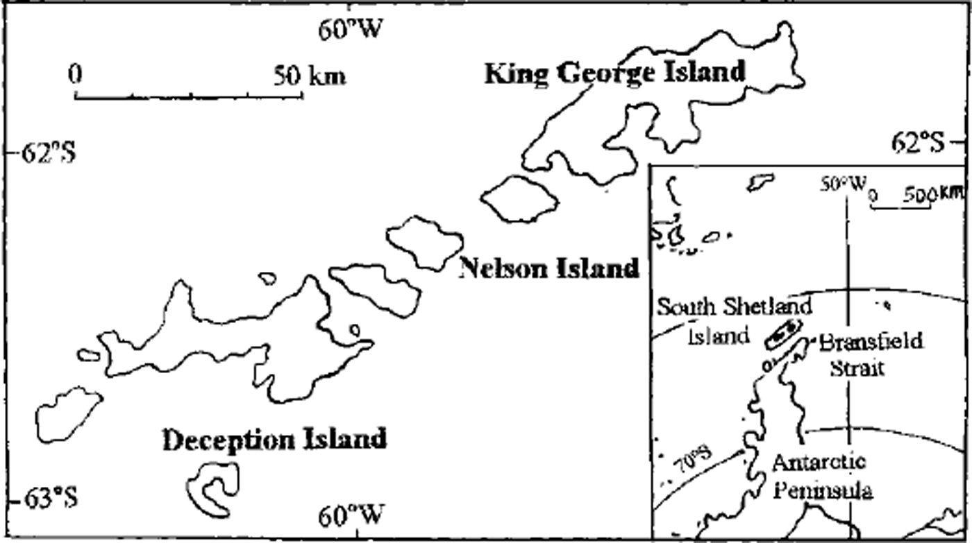
Fig 1. Map showing the position of King George Island and Deception Island, SSI
King George Island, about 120 km from the active volcanic Deception Island, is the largest of the SSI that have been volcanically active in historic times (Fig. 1). More than 90% of King George Island is covered by the Collins Ice Gap. Several ice cores, one of which reached 80.2 m in depth, were recovered in the 1991-93 field Campaign by the Chinese Antarctic Research Expedition (CHINARE) at a dome summit (62°10’S, 58°50’W; 252 ma.s.l.), Nine horizons with coarse, dark-brown material were displayed along the 80 m core. Structural and mineral analysis revealed the characteristics of volcanic ash contained in the horizons. Core-dating given by a modeled time-scale based on the investigation of ice dynamics, mass balance, radar-echo sounding, etc., established the corresponding age of the horizons. Two essential questions will be stressed in our discussion: (1) Gould these horizons represent the volcanic eruptive sequence for a certain historic period in the SSI region? (2) What is the relation between the established volcanic sequence and the available historical records?
Ice Gores and Visible Volcanic Deposits
Collins Ice Cap consists of a few domes up to some 700 m a.s.l. The 1991-93 fieldwork, including drilling activity, was carried out in a 20 km long section connecting two domes, High Dome at 702 m a.s.l. and Low Dome at 252 m a.s.l., in the western part of the ice cap (Fig. 2). Low Dome is about 3 km from the Uruguayan research station, Artigas (Fig. 2). A comprehensive glaciological study of mass balance, thermal regime, equilibrium-line altitude (ELA), ice-formation zones, the structure of snow-firn sequences, etc., was conducted along the main divide of the section over a period of more than 1 year (October 1991-January 1993). It was revealed that the ice in the study area is polythermal: temperate on High Dome and cold on Low Dome (Reference Jiankang, Huijun, Jiahong and XinchunHan and others, 1995b). The very high accumulation rate (up to 4 m snow a-1) and limited drilling depth (about 50 m, at which depth a water film was encountered) restricted the collection of a long-term climatic-environmental record for High Dome. Low Dome, however, with much less accumulation, favorable physical properties and longer cores, provides an opportunity for longer records.
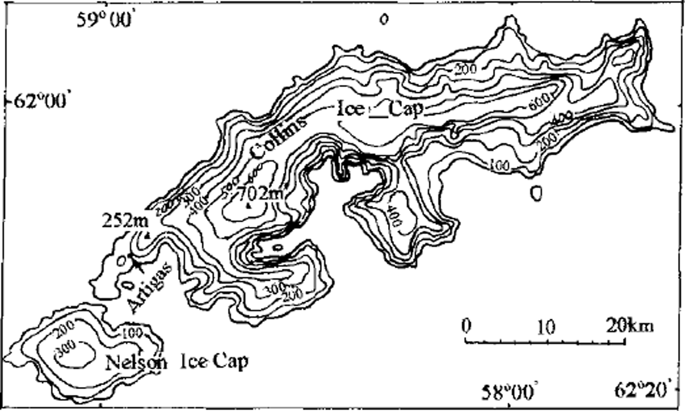
Fig. 2. Map showing the location of work carried out on the Collins Ice Cap and the coring site at the summit of Low Dome. Contours are surface elevation (m).
Low Dome is situated on a subglacial hill with a bowl-like concave top, according to the bedrock topography study by Reference Guocai, Xiaoping, Jiankang, Xinsheng, Jiancheng and JiahongZhu and others (1994). The summit of the dome shows a smooth surface with an ice thickness of ∼ 120 m The annual mean air temperature is 5.7°C, estimated by extrapolating from the long series of meteorological data accumulated at the stations on King George Island (Reference Hanjiankang, Jiahong, Lluberas and RodriguezHan and others, 1994). Borehole-temperature measurements below the surface suggest cold ice (0.65°C) at 50 m depth and (-1.2°C) at the bottom of the active layer (-12-15 m below the surface; Reference Jiankang, Huijun, Jiahong and XinchunHan and others, 1995b). The horizontal ice movement at the summit of Low Dome is 0.328 m a-1 (Reference Wanchang and JiankangZhang and Han, 1994). The ELA of the ice cap has been fluctuating in the range 140-160 m a.s.l. in recent years (Reference Zichu, Jiahong and JiankangXie and others, 1994), well below the elevation of the dome summit (252 m a.s.l.). Moreover, the ELA did not rise significantly in 1989, the warmest year in the past century (Reference Jiankang, Chenhai and JianchengHan and others, 1995a). This suggests that no loss of historical annual layers has occurred, at least for the past century. The disadvantage of Low Dome as a coring site for climatic-environmental study is its low elevation and consequent surface melting in summer seasons. Our in situ daily meteorological observations on the summit logged air temperatures above 0°C for several hours, as well as occasional rainfall. The substantial melting of the surface snow by these mechanisms and the resulting percolation into the snowpack may have caused the migration and relocation of the soluble impurities, probably smoothing the chemical signals recorded in the snow. Thus, long seasonal resolution was not considered available in profiles. However, ice-formation mechanism studies (Reference Hanjiankang, Jiahong, Lluberas and RodriguezHan and others, 1994,Reference Jiankang, Huijun, Jiahong and Xinchun1995b; Reference KoernerKoerner, 1997; Reference Grumet, Wake, Zielinski, Fisher, Koerner and JacobsGrumet and others, 1998) suggest that some information other than the seasonal variations might still exist in the core. The critical reason for this preservation is that the cold ice beneath the active layer holds the melting water in the current annual layer so that it is refrozen the following winter. It thus protects annual deposits from deeper percolation and further mixing with the previous snow mass. This mechanism is probably also responsible for the interleaving distribution of firn and ice layers in the upper part of the core due to short-term alternation of warm and cold weather after the intensive summer melt. It could serve as an indicator of annual layers.
Six ice cores were extracted from a 20 m x 20 m area on the summit of Low Dome. All cores show similar visible features, the most prominent of which is the common appearance of horizons with brown, dark-brown or lignite-like coarse material along the macroscopic stratigraphy (Fig. 3). The longest core, 80.2 m long, has nine such horizons where the dispersed or concentrated particles are included (Table 1). The scatter grains sampled in the melt are sized in the range 0.11-0.50 mm, with 0.27 mm predominant for long-axis measurement. The sharp angular shape of the grains is indicative of the bubble-wall shards and lack of weathering or modification after formation (Reference DaiDai and others, 1993). Optical examination under a polarizing microscope revealed the characteristic structure of an extrusion, composed of opaque metals dominantly and glass shards secondly. Numerous granular air bubbles and micro-porphyritic crystals in the interior of the grains provide supporting evidence for their volcanic nature. Further evidence of the tephra morphology was found under an electron probe (Fig. 3). Qualitative analysis using a Model EPM-810Q electron probe determined the elemental composition: Si, Ti, Fe, A1, Mn, Mg, Ca, K, O, Na, among which Si, Al, Fe and Mn show the highest content (Reference DaiDai and others, 1993). All these well-defined layers are indicative of original deposition.

Fig. 3. A group of photographs showing the visible ash layers in the ice core and the optical microscopic structures, (a,b) Dark-brown volcanic ash layers in the horizons of Collins Ice Cap cores, (c) Double electronic image showing the tattered granular air bubbles and conchoidal fracture on the surface of tephra grains, (d) Double electronic image showing the tattered elliptic air bubbles in the interior of tephra grains.
Table 1. Visible volcanic deposits along the 80.2 m ice core
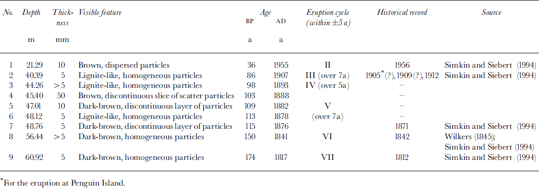
Besides those nine common horizons, some "dirty-bands are found in several cores. These bands appear cloudy because they contain wind-blown dust particles, but are lighter in color than the horizons. Most of the bands in other cores are cross-correlated to those in the 80.2 m core for age determination using the prime index layers of volcanic tephra deposit common among the cores. The "dirty" layers spaced more-or-less regularly along the core were taken as references for the calculation of the thinning rate of annual layers. A couple of them at about 11m depth could be the indicative signal of known eruptions (e.g. 1970 eruption on Deception Island), but were not treated as such due to their random appearance.
Age Determination
Various methods for dating cores (e.g. electrical conductivity measurements (Reference HammerHammer, 1980, Reference Hammer1983), ionic chemistry stratigraphy, the pattern of bomb-produced total fi activity (Reference Langway, Osada, Clausen, Hammer, Shoji and MitaniLangway and others, 1994) and multi-parameter time series combined with δ18O curves) do not work properly on Low Dome owing to the eluviation mechanisms noted above. Thus, we turn to numerical modeling to date the Collins ice cores.
Based on the physical properties of Low Dome, it is reasonable to assume that the dome is in near steady state with a continuous deposition sequence. It is possible that some melting occurs at the base of the dome. But the ice-core dating for this study is limited to the upper part of the core, well above the bed, so a frozen base is also an acceptable assumption.
The age, T, at ice-equivalent distance y above the bed at the center of a steady-state ice sheet is (Reference PatersonPaterson, 1981)

where h is the ice-equivalent thickness and v is the vertical velocity, expressed as the distance an ice particle moves downwards in lyear, which must be equal to the thickness of one annual layer. Age is calculated from some assumed relation between v, or rather the thinning rate du/dy (the horizontal movement could be treated as zero at the drilling site), and y.
Considering that the vertical strain rate cannot be uniform with depth if the ice is frozen to the bed, Reference Dansgaard and JohnsenDansgaard and Johnsen (1969) used a flow model with vertical strain rate constant down to some distance h′ above the bed and decreasing linearly from there to zero at the bed. This model was adopted in our study.
Equation (1), which is the basis for these time-scales, is true only where there is no horizontal ice movement, i.e. at an ice divide. As stated above, the ice at the summit of Low Dome moves very slowly, indicative of its position very close to the ice divide. As the ice thickness, annual accumulation rate and therefore the vertical velocity, v, do not vary greatly in the drilling area (Reference JiahongWen and others, 1994; Reference Guocai, Xiaoping, Jiankang, Xinsheng, Jiancheng and JiahongZhu and others, 1994), the subsequent equations of the model illustrated by Reference Dansgaard and JohnsenDansgaard and Johnsen (1969) are valid. The position of h′ was determined by the varying thickness of annual layers along the core. As shown by the visible stratigraphy (Reference Hanjiankang, Jiahong, Lluberas and RodriguezHan and others, 1994) the annual layer thickness at Low Dome summit is approximately 0.7 m (ice) at -2.5 m depth. The annual layer is reduced to some 0.4 m (ice) at ∼28 m depth, as indicated by the mean interval between two neighboring "dirty" layers. Thus the calculated thinning rate of the annual layer is du/dy ≈ 0.011, and h′ = 113 m when the accumulation rate, c= 0.7 ma-1, and the ice thickness, h = 120 m, at the summit are accounted for. The time-scale calculated by this model is plotted in Figure 4. A similar time-scale was constructed earlier by using the well-known ice-flow law (Reference Wanchang and JiankangZhang and Han, 1994).

Fig. 4. The tine-scale calculated using the Dansgaard-Johnsen model for the 80.2 m ice core from Low Dome of Collins Ice Cap.
Establishment of Volcanic Eruption Sequences
With the calculated time-scale, two key time limits are first determined. The ice 10 m above the bedrock of Low Dome is aged 1897 a BE The bottom of the long core at 80.2 m corresponds to an age of 360 a BE The former implies that the reliable records from this subantarctic ice cap go back to some 2 ka BE, and the latter indicates that the extracted 80.2 m ice core contains about 340 years.
The ages for the volcanic ash horizons are listed in Table 1. Taking into account the maximum difference between the calculated age and the nearest historical record (e.g. Reference Simkin and SiebertSimkin and Siebert, 1994), ±5 years was allowed for dating error. This suggests that the most recent volcanic eruption recorded by our core is that in 1956 at Deception Island. Our dating of the horizon at 40.4 m suggests eruption(s) around 1907, close to that at Deception Island (1912 or 1905?) or to that at Penguin Island (1905?). The most frequent eruptions recorded in our core were concentrated in the fourth quarter of the 19th century. However, four of five horizons in that period have not been reported previously. The 1842 eruption as described by Reference WilkersWilkers (1845) left a distinct trace in our core, with only a lyear difference in the dating. The earliest record provided by the Low Dome core was in 1817, when an eruption occurred at Deception Island (Reference Simkin and SiebertSimkin and Siebert, 1994). Thus, several recorded eruptive activities at Deception Island, as compiled by Reference Simkin and SiebertSimkin and Siebert (1994), are found in our cores, but not the most recent (1967-70) or the earliest (1800).
The absence of ash layers corresponding to the eruptions in 1967-70 at Deception Island poses a significant question for the calculated time series. An attempt was made to construct another series by taking the tephra horizon at 21.3 m as the index of the 1970 eruption. However, in the new series most other volcanic horizons do not match with any recorded eruptions within a range of 10 years. So it appears that this alternative series is unacceptable. As mentioned above, we found a couple of dirty bands at about 11 m depth. These could be the indicative signal of the 1967-70 events according to our modeled time-scale. Actually, in some of the Nelson ice cores (Qin and others, 1994) the 1967-70 eruptions were exhibited as scattered particles, too. The fact that the 1967-70 eruptions are not recorded as dark horizons in Low Dome cores suggests that the original eruptive ash did not reach the drilling site, even though the drilling site was within 10 mm of the tephra isopach produced by the 1970 eruption (Reference González-FerranGonzález-Ferran, 1991). This also seems contrary to Qin and others’ (1994) observation in the Nelson Island ice core. This discrepancy may be explained by the 8-10 km distance between the two sites. Another possible explanation is that Low Dome is located slightly off the track of the predominant (east-northeastward, i.e. clockwise over Antarctica) wind direction. The above may explain the appearance of dirty bands rather than ash layers for the 1967-70 eruptions in Low Dome cores.
A single volcanic eruption usually lasts a very short time, but the dynamic subduction process causing volcanic eruptions often lasts for a few years. For instance, the 1967-70 eruptions at Deception Island are actually three phases of one eruptive cycle (Reference González-FerranGonzález-Ferran, 1991). With this in mind, we grouped the eruptions recorded in the Collins Ice Gap core into cycles of 5 years, i.e. the eruption series within a 5 year time interval are brought into one group as a cycle. Including the 1967-70 cycle, the 340 year history covered by our core contains seven eruptive cycles (Table 1). The longest (a combination of two successive cycles) lasts for 7 years. Because of the possible absence of a full cycle, the seven cycles should be regarded as the minimum for the past 340 years. These eruptive cycles outline the general history of volcanic activity in the SSI region. The events falling into cycles IV and V, most of which have not been reported previously, should be specially investigated, perhaps utilizing ice cores from other glaciers in the SSI region.
Conclusions
Nine volcanic ash horizons are found in an 80.2 m ice core from Collins Ice Gap. The volcanic origin of these horizons is confirmed by mineral and chemical analyses.
Assuming the ice cap is in steady state, the Dansgaard-Johnsen flow model was constructed to date the core. A time series of volcanic eruptions in the SSI region since AD 1650 was thus established. Seven volcanic eruption cycles can be distinguished during the past 340 years. During the period 1875-1925, there seem to have been frequent volcanic eruptions, many perhaps on Deception Island. The period 1650-1800 appears to be quiet. This was followed by a century of higher volcanic activity. The past century has been a volcanically tranquil era except for a few turbulent periods at the beginning of the century and during the 1950s-70s.
Most of the recorded eruptions at Deception Island, as compiled in Reference Simkin and SiebertSimkin and Siebert (1994), have been found in the Collins Ice Cap core. A few horizons do not correspond with any eruptions in the compiled list, These may be previously undiscovered or unreported eruptions in the region. The absence of a distinct horizon for the most recent volcanic events in the period 1967-70 suggests that the volcanic eruptions found in this study may represent a minimum in the eruptive history.


