


Introduction
Grasshopper Glacier is a small cirque glacier, located at approximately 45°08'N. latitude and 109°53'W. longitude, in the Beartooth Mountains of Montana, in the central Rocky Mountains of the United States. The glacier is located at about 3000 m elevation in a northward-facing depression where it receives maximum shading from the sun and maximum snow deposition, It is similar in size and aspect to several other glaciers in the area, none of which have been intensively studied. The area is one of the three major concentrations of glaciers in the U.S. Rocky Mountains (Reference GrafGraf 1977). The glaciers are thought to be remnants of the Little Ice Age, rather than dating back to the more widespread and older Pinedale Glaciation (8-23 000 years BP) (Reference GurneyGurney 1953).
This glacier was named because of remains of numerous grasshoppers found on the surface and within the ice of the glacier, In 1952, grasshoppers from the lower part of the terminal face were dated by Irving Friedman of the U.S. Geological Survey, using carbon-14 methods, in an attempt to support the age estimates of the glacier. His results were unreliable, but they did support the idea of the glacier being Holocene in age (Reference GurneyGurney 1953). When the author visited the glacier in 1981, the grasshoppers were scarce or non-existent.
The glacier has not been monitored on a regular basis and very few maps have been compiled of the area, but it has been visited, studied, photographed, occasionally mapped, and described by scientific and non-scientific groups since the first recorded visit in 1898. These photographs (both ground and aerial), together with cartographic and written records, make it possible to trace the fluctuations of this glacier since 1898 and estimate quantitatively, for the first time, the amount of recession that has taken place.
Availability of Cartographic, Photographic or other Remotely-Sensfd Data
Other remotely-sensed data were also looked at as a possible source of information on the changes in Grasshopper Glacier, but none were useful.
Because of the scarcity of map, aerial-photographic, or other remotely-sensed data, the following discussion of glacier fluctuation is therefore based on the available cartographic and aerial-photographic data, ground photography, and verbal descriptions from many visitors to Grasshopper Glacier through the years.
Fluctuation of Grasshopper Glacier
The first documented visit to Grasshopper Glacier was made by James P. Kimball and his surveying party, in August, 1898 (Reference KimballKimball 1899), Kimball was accompanied by a photographer named A.B. Wilse, who took photographs of the glacier (see Fig.1). The glacier was described as being very active. The minimum slope of the surface was considered to be 25-30°. The map produced by Kimball at 1:125 000 depicts the glacier with a poorly-defined boundary. The best estimate of the glacier area in 1898, based on the map, Wilse’s photographs, and verbal description, is 0.82 x 10⁶m2.
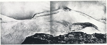
Fig. 1 Photograph of Grasshopper Glacier, taken in 1898 by A.B. Wilse.
William C. Alden visited the glacier on July 14, 1922. Alden, a geologist with the U.S. Geological Survey, was requested by the National Park Service to make an examination of Grasshopper Glacier. He estimated the glacier to be 800 m from front to back and 1.6 km from side to side (Reference AldenAlden, unpublished). Alden documented his visit with ground photographs.
In August of 1939, S.A. Macauley (Reference MacauleyMacauley 1940) visited the glacier and described a vertical ice cliff at the toe of the glacier, 15 m high.
Dr J.R, Parker visited the glacier several times between 1918 and 1949 (Reference GurneyGurney 1953), In Dr Parker’s estimation, the glacier appeared in 1918 much as it did in Wilse’s phot0ograph of 1898. In visits in 1922 and about 1926, the general appearance remained the same. The ice cliff at that time was 15-23 m high. During a visit in 1931, he estimated the face was 8 m lower. In 1949, Dr Parker found the face had receded by melting, and there was a gentle upward slope to the snow-covered ice against the mountain.
In September 1949, the first aerial photography was flown over the area. Using this photography, the surface area of the glacier was planimetrically estimated to be 0 58 x 106m2.
In 1967, Donald Alford and Robert Clark carried out a mass-balance study on Grasshopper Glacier. They described the glacier as being 1 km wide by 0.5 km long. Their mass-balance figures show net ablation in the center of the glacier, net accumulation on the sides, and an overall, specific, mass balance of ±0.81 m of water equivalent (Reference Alford and ClarkAlford and Clark 1968). In 1968, Donald Alford repeated his study and determined a specific net mass balance of ±0.53 m (Reference AlfordAlford 1970). However, records from the closest weather station show that precipitation was substantially above average in 1967 and 1968.
In August 1981, the glacier was visited by the author. In contrast with 1898, the glacier was very inactive. Photographs were taken to compare with many of the historic photographs and to document the current glacier conditions. In some cases, it was impossible to duplicate historic photographs taken on the ice surface, because the surface itself had melted to a considerably lower level in the intervening years and it was impossible to obtain the same perspective. A specific photograph of the glacier was taken (see Figure 2) for comparison with Wilse’s 1898 photograph. Aerial photography, taken two weeks later, showed that the glacier had melted into two separate smaller ice patches. The total surface area of the two parts was determined by planimetry to be approximately 0.425 x l06m2.

Fig. 2 Photograph of Grasshopper Glacier, taken in 1981 by J.G. Ferngno.
An attempt has been made to try to delineate the recession of the glacier, based on the aerial and ground photographs and the description of the glacier by various visitors since 1898. The results indicate that Grasshopper Glacier has lost about 50% of its area and as much as 90% of its volume, during the 83 years between 1898–1981 (see Figure 3).

Fig. 3 Sketch map and Cross-section of the estimated area and thickness of Grasshopper Glacier in 1898, 1950, and 1981. The 1898 profile is an estimate based on a 1:125 000-scale map ground photographs, and verbal descriptions. The 1950 and 1981 profiles are based on aerial and ground photographs.
Comparison with other Rocky Mountain Glaciers
Because of the substantial retreat of Grasshopper Glacier, it was decided to review data on other Rocky Mountain glaciers, to see if they showed similar behaviour.
Some of the best studied of the U.S. Rocky Mountain glaciers are those of the northern Rockies in Glacier National Park, Montana. The largest of these are the Grinnell and Sperry Glaciers. The Grinnell and Sperry Glaciers were discovered in 1887 and 1895, respectively. They have been systematically mapped since 1900. Between 1900 and 1966, Grinnell Glacier decreased from 2.15 x 10⁶ m2 to 1.21 x 10⁶ m2, a 44% reduction in area. Sperry Glacier decreased from 3.24 x 10⁶ m2 in 1901 to 1.16 x 10⁶ m2 in 1960, a 64% reduction in area (Reference JohnsonJohnson 1980). These two glaciers are located further north than Grasshopper, but are at a lower average elevation, 2010 m for Grinnell Glacier and 2380 m for Sperry Glacier.
Arapaho Glacier was selected as an example of southern Rocky Mountain glaciers. Arapaho is described by Reference WaldropWaldrop (1964) as the largest glacier in Colorado and the southernmost active glacier in the Rocky Mountains. Its average elevation is approximately 3870 m. When first studied in 1900, its area was 0.34 x 10⁶m2. Between 1900 and 1960 it lost 0.09 x 10⁶m2 or about 26% of its area. Its maximum area was estimated to be 0.46 x 10⁶m2, in 1860 (Reference WaldropWaldrop 1964).
Conclusions
Based on this small sampling, it would appear that, with the exception of a few minor instances of positive mass balance, the U.S. Rocky Mountain glaciers have been steadily decreasing in size during their historical record. If climate conditions and the rate of retreat remain fairly constant, and if these glaciers are representative, the U.S. Rocky Mountain glaciers will have disappeared by the middle of the next century.
Table I Cartographic and Photographic Information most useful for Evaluation of Fluctuations of Grasshopper Glacier


