


Introduction and Regional Setting
Ice-flow-transverse subglacial ridges (Rogen moraines) which grade spatially into drumlins are prominent bedforms in north and east-central Ireland (Reference Knight and McCabeKnight and McCabe, 1997). The ridges (0.5–2.5 km long, 100-450 m wide, 15-35 m high) are present in lowland areas (60–130 m a.s.l.) where glacial sediments are thickest (~30 m) and reflect northwest-southeast ice flow towards the Irish Sea (Reference McCabe, Knight and McCarronMcCabe and others, 1999) (Fig. 1). Rogen moraines, thought to form when the ice bed changes from cold- to warm-based (Reference LundqvistLundqvist, 1989; Reference HattestrandHattestrand, 1997), record subglacial environments around the time ofor immediately after the last (Devensian) glacial maximum (LGM, ~21 — 1814 C kyr BP), when the ice sheet was undergoing fundamental changes in thermal regime. The Rogen moraine ridges show symmetric and asymmetric cross profiles and have intricate outlines.
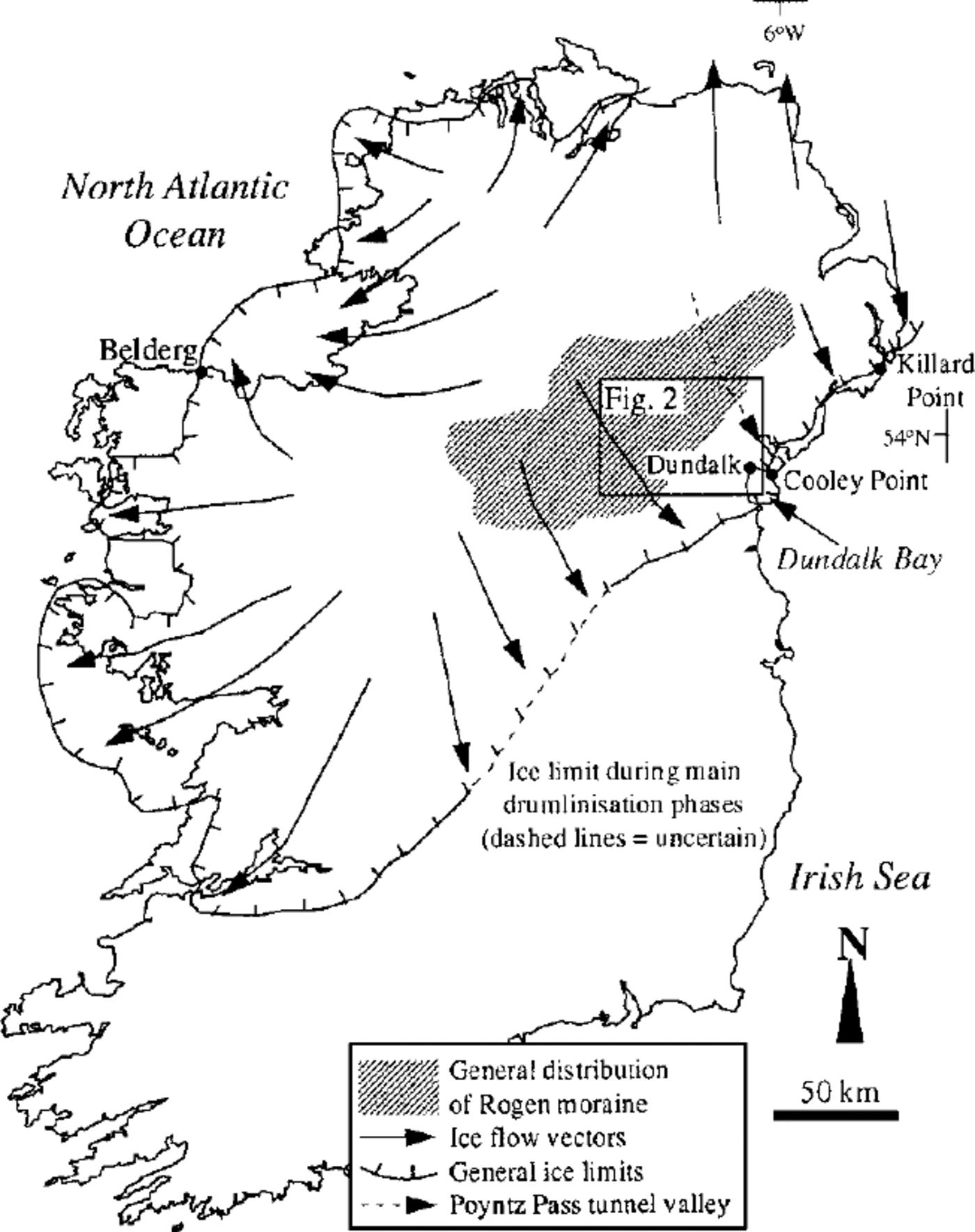
Fig. 1. Study area showing generalized distribution of Rogen moraine and main ice-flow vectors and limits during late- Devensian drumlinization phases.
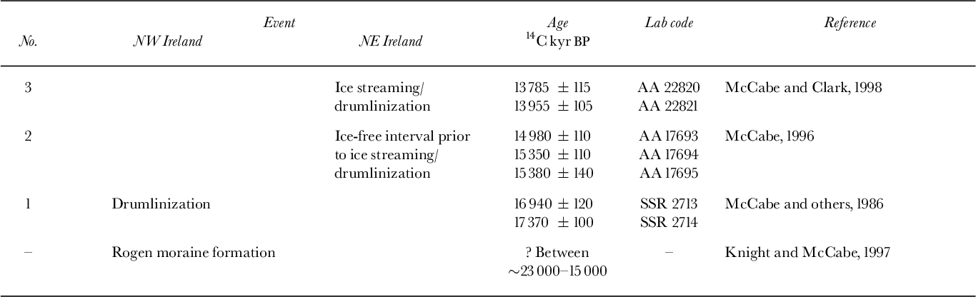
Three dated glacial events have modified this pre-existing bedform pattern (Table 1). (1) In northwestern Ireland, the crests of some Rogen moraines were streamlined from east-to-west during drumlinization (fast ice flow and sediment streamlining) emanating from north-central Ireland ice centres (Reference Knight and McCabeKnight and McCabe, 1997). Drumlinization is 14C dated from marine molluscs present within ice-marginal sediments at Belderg, western Ireland to before 17.014 C kyr BP (Reference McCabe, Haynes and MacMillanMcCabe and others, 1986). (2) In eastern Ireland, Rogen moraine crests were streamlined from northwest-to- southeast, and sediment transported to subaqueous morainal banks at tidewater ice margins (Reference McCabe, Knight and McCarronMcCabe and others, 1999). At Cooley Point, marine mud beds containing in situ tests of the foraminifera Elphidium clavatum, are immediately overlain by morainal banks which were deposited as ice advanced into the sea (Reference McCabeMcCabe and Haynes, 1996). E. clavatum faunal assemblages are accelerator mass spectrometry (AMS) 14C dated to around 15.014C kyr BP and provide a maximum age for this ice advance (Reference McCabeMcCabe, 1996). (3) In eastern Ireland, bedforms were modified by a renewed phase of fast ice flow in which high sediment fluxes to ice margins built up subaqueous morainal banks and deltas (Reference McCabe, Dardis and HanveyMcCabe and others, 1984, 1987). Dating of E. clavatum from synformational mud beds within the Killard Point moraine shows that this period of fast ice flow occurred around 13.814C kyr BP (Reference McCabe and ClarkMcCabe and Clark, 1998). These age assessments enable regional-scale phases of ice activity to be evaluated within an absolute temporal framework from bedform patterns (Reference Knight and McCabeKnight and others, 1997). This paper examines the effects of bedform modification in east-central Ireland during events 2 and 3 (above), which are some of the last known phases of late-Devensian Irish ice-sheet activity. The well-defined bedform distributions and their relationship to ice margins allow inferences to be made about the subglacial drainage regimes of ice streams. Here ice streams are defined as discrete regions of enhanced ice flow developed within a uniform ice mass.
Table 1. The timing of bed-form-shaping events on the coast of Ireland.
Bedform Patterns in East-Central Ireland
Bedforms along the east coast of Ireland, between Dundalk Bay and Killard Point, traditionally form part of a major drumlin-moraine system straddling the east and west coasts (Reference Synge and WrightSynge, 1969) (Fig. 1). However, careful examination shows that more complex morphological patterns exist. Regional- scale bedform patterns and ice-flow vectors are identified using Landsat thematic mapper (TM) imagery and aerial photographs, and corroborated by mapping and sedimentological investigation of individual field sites (e.g. Reference Knight and McCabeKnight and McCabe, 1997; Reference McCabe, Knight and McCarronMcCabe and others, 1999). Two palaeo-ice streams are identified as discrete, elongated areas of modified bedforms that track inland (Figs 2a and b). Ice-stream margins are identified on the basis of lateral changes in bedform morphology. Four bedform morphological types (types A-D; Fig. 3) are recognized on the basis of bedform outline shape, style of modification, spatial pattern and location, and internal sediments. The four morphological types are arranged spatially in zones dominated by a single bedform type, although other types are sometimes present (Fig. 2b). The boundaries between adjacent zones are transitional, but may change over a few hundred metres especially around ice- stream lateral margins. Bedform morphology changes along a continuum according to the degree and style of modification by ice activity. Up-ice from the ice margin located in Dundalk Bay, the morphological continuum consists of streamlined mounds and ridges (morphological type A) →cross-cut ridges (type B) →re- moulded/overprinted ridges (type C) → unmodified ridges (type D). These are marked in discrete zones labelled A-D respectively (Figs 2 and 3).

Fig. 2. (a) Landsat TMimage (2 May 1990, scene 206/22) showing range of glacial bedform types: D = Dundalk, Cr = Cross-maglen, Ca = Castleblaney, K = Keady, A = Armagh. Striped area west of Armagh is cloud cover, (b) Sketch of same area showing principle topographical features, ice-stream margins and morphological zones A-D.
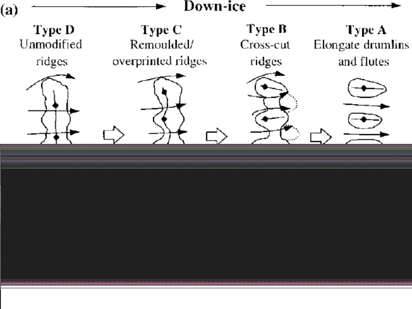
Fig. 3. (a) Schematic diagram of bedform morphological types A-D in east-central Ireland. Bedforms change along down-ice gradient. (b) Sketch of bedform cross profile and internal sediments within each bedform type.
No discernible bedforms are present up to 6 km inland from Dundalk. This is due to infilling by postglacial estuarine sediments. Type A bedforms occur up to 10-15 km further inland and comprise dispersed, elongated drumlins and flutes (< 500 m long, 100 m wide, 15 m high) which overlie glaciated bedrock surfaces. Bedrock-cored drumlins (< 20 m high) are present near the inland margin of this zone. Type B bedforms occur in a zone 2-10 km wide and comprise bedrock-dominated ridges with a thin (< 10 m thick) diamict cover. The ridges (0.5–1.5 km long) are cleanly cross-cut by flow-parallel meltwater channels and are composed of discontinuous lines of classically shaped drumlins which show steeper stoss than lee slopes. The meltwater channels (5-20 m deep, < 200 m long) vary from shallow scours along ridge crests to deep cuts which extend to the ridge base. Some drumlins, such as around Muckno Lough (Fig. (Fig 4), show small-scale undulating diamict ridges (2–10 m thick) along drumlin and ridge flanks, giving a serrated long profile. Diamict generally thickens towards the bedform leeside and small (< 200 m2) off lapping subaqueous fans composed of sandier sediments are present at the lower end of meltwater channels (Fig. 3b). Remoulded and overprinted Rogen moraine ridges make up Type C bedforms, which occur in a zone 6–12 km wide. These ridges (1— 2 km long) are composed mainly of diamict, are morphologically intact (i.e. can be linked by a basal enclosing contour) and show both up- and down-ice convex components in plan view which are separated by shallow (2–10 m deep) saddles. Ridge crests are streamlined (individually < 200 m wide, 500 m long), sinuous in plan view, and separated by shallow scours (< 10 m deep). Sediments in these ridges are composed of rubbly, angular, locally derived debris supported by a minor sand and granule matrix (Reference McCabe, Knight and McCarronMcCabe and others, 1999). Some ridges also contain cut-and-fill channelized gravels, smoothed off to the level of ridge crests. Type D bedforms consist of unmodified (non-streamlined) Rogen moraines (< 5 km long, 0.5 km wide, 30 m high). These bedforms have undulating crestlines, generally symmetric cross profiles and complex basal outlines. This bedform type is located mainly in basin areas outside ice-stream lateral margins. Bedform types A and D show relatively less morphologically variability than types B and C, which are concentrated between 100–150 m a.s.l. and on down-ice descending slopes (5–10°) (Fig. 2).
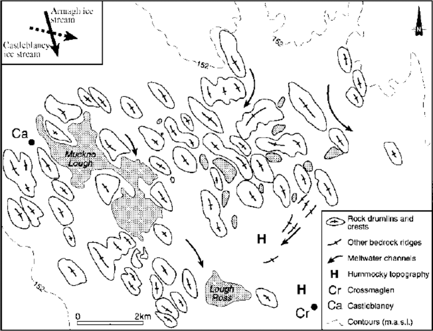
Fig. 4. Morphology of bedforms in the Crossmaglen area.
Discussion
Ice-Stream Extent And Chronology
The Castleblaney and Armagh ice streams have contrasting morphological characteristics and occur in contrasting geographical settings. (1) The Armagh ice stream (46 km long, 2–5 km wide) narrows inland along a sinuous path extending from Dundalk Bay to Armagh (Fig. 2). The ice stream crosses the topographical watershed (190 m a.s.l.) at Mullyash Mountain (320 m a.s.l.). Outside ice-stream margins, Rogen moraines are not modified (type D), but they are streamlined and reoriented into types B and C bedforms within the ice- stream margins. (2) The Castleblaney ice stream (18 km long, 10 km wide), located in lowland areas, is not as morphologically distinct as the Armagh ice stream. Castleblaney ice stream margins are less clearly defined and zonal bedform patterns are not as well-developed. Morphologically, type B bedforms dominate with type A bedforms occurring near Crossmaglen. The head of the Castleblaney ice stream is clearly defined and terminates at the topographical watershed (140 m a.s.l.) east of Ballybay.
The relative timing of ice-stream activity can be evaluated by looking at bedform patterns near Muckno Lough where the lateral margins of both ice streams intersect (Figs 2b and 4). In this area the trace of the Castleblaney ice stream is intersected (at ~40°) and stratigraphically overlain by components of the Armagh ice stream. Bedforms in this area (types A and B) comprise bedrock-cored ridges and drumlins, overlain by diamict, and show two main directional components (Fig. 4). An earlier west-northwest— east-southeast bedform set (Castleblaney ice stream) is overlain stratigraphically by a north-northwest—south- southeast bedform set (Armagh ice stream). Bedrock ridges around Crossmaglen mark an earlier ice advance from the northeast (Reference McCabe, Knight and McCarronMcCabe and others, 1999). Activity of the Armagh ice stream is associated with the deposition of subaqueous fans on the leesides of some cross-cut ridges (type B bedforms). Similar minor diamict ridges and subaqueous fans have been associated with shifts in ice-stream flow direction of the Laurentide ice sheet (i.e. Reference Hicock and FullerHicock and Fuller, 1995). In Ireland, deposition of subaqueous sediments has been related to mass flows within subglacial leeside cavities (i.e. Reference Dardis, McCabe and MitchellDardis and others, 1984). This morphological evidence suggests strongly that the Armagh ice stream postdates the Castleblaney ice stream, and is consistent with the overall off lapping pattern of northward ice retreat around the Irish Sea basin (Reference McCabeMcCabe, 1997).
Regional-scale controls on ice-stream initiation and extent
Tidewater ice margins, high relative sea-level (RSL) and glaciomarine sedimentation are known to have occurred along the eastern Irish coast during the last deglaciation (Reference McCabeMcCabe, 1997). As the ice streams identified in east-central Ireland trend eastwards towards the Irish Sea, it is proposed that high RSL and marine downdraw of the ice margin (Reference HughesHughes, 1986) were responsible for destabilization of the ice-sheet margin and initiation of ice streaming. This model is supported by regional geomorphological and sedimentary evidence, described elsewhere, for subaqueous morainal banks built by the high marginal sediment and meltwater fluxes associated with fast ice-flow events in eastern Ireland (Reference McCabe, Dardis and HanveyMcCabe and others, 1984, 1987; Reference McCabe and ClarkMcCabe and Clark, 1998).
The shape and bedform modification patterns of the Castleblaney ice stream, constrained within a basin and demarcated by a topographical divide, suggest strong overall topographical control and weak downdraw of the ice margin during ice streaming. At Cooley Point on the eastern margin of Dundalk Bay, open-water marine muds dated to around 15.014 C kyr BP are overlain by prograding outwash sediments which indicate ice readvance and rising RSL (Reference McCabeMcCabe and Haynes, 1996). It is proposed that this regional ice readvance is related to activity of the Castleblaney ice stream when the ice margin moved forward into a marine environment. The ice stream may have been supported by meltwater during re lease from subglacial storage in cavities (e.g. Reference KambKamb, 1987) associated with type C and D bedforms (Fig. 5).
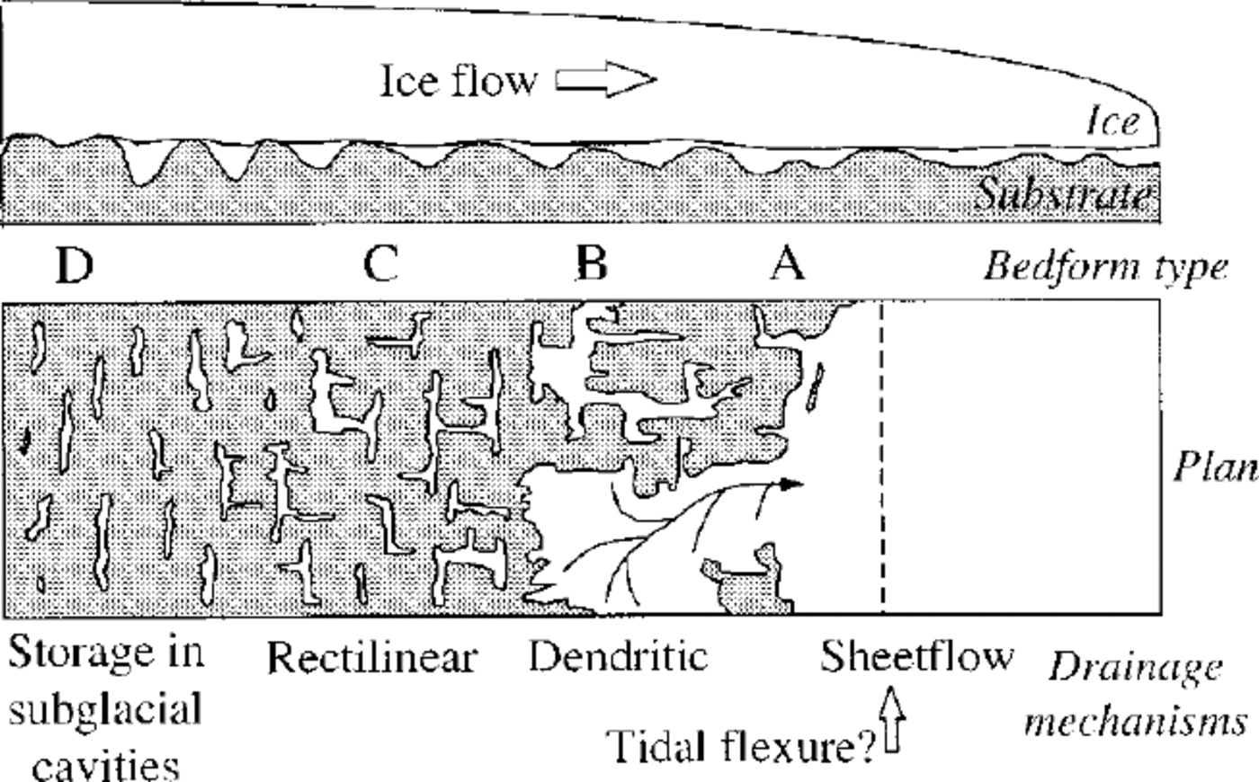
Fig. 5. Schematic model of changes in subglacial storage and drainage paths along ice-stream tracks.
The geometry and bedforms of the Armagh ice stream attest to stronger marine downdraw of the ice margin and steep longitudinal ice gradients. Strong downdraw is associated with high RSL, ice-bed decoupling, and fast ice advance from inland centres (Reference HughesHughes, 1986), all of which occurred in eastern Ireland. Activity of the Armagh ice stream is correlated with the deposition of synformational gravel, sand and mud beds within the Killard Point moraine, which formed during regional ice readvance into the Irish Sea (Reference McCabe, Dardis and HanveyMcCabe and others, 1984). The Killard Point moraine (dated to 13.814 C kyr BP) forms part of the semi-continuous end-moraine belt fronting the streamlined topography of eastern Ireland (Fig. 1). Similar estimates of high RSLs at Killard Point (~+20-30 ma.s.l.; Reference McCabeMcCabe, 1996, 1997) to those observed in Dundalk Bay strongly suggest a similar downdraw hypothesis and timing of fast ice flow along the Irish east coast. The moraine sequences, genetically related to phases of ice streaming (Reference McCabe, Dardis and HanveyMcCabe and others, 1984, 1987), do not show marked depositional hiatuses, suggesting sedi- ment/meltwater fluxes were quasi-continuous throughout this period (15.0-13.814C kyr BP).
Bedform modification patterns and subglacial processes
The down-ice changes in patterns of bedform modification (Fig. 3) broadly reflect the magnitude of the basal sediment/ meltwater flux (i.e. ice speed) and the time period of ice streaming. As marine downdraw is generated and controlled at the ice margin (Reference HughesHughes, 1986), the overall period of ice streaming decreases headward. Therefore bedforms formed under strong downdraw conditions would be expected to show a steep morphological gradient (i.e. Armagh ice stream) and reflect the reorganization of subglacial sediment and meltwater fluxes during ice streaming. It is therefore proposed that subglacial-sediment and meltwater- transport processes and paths changed in concert along this morphological gradient (Fig. 5).
Unmodified Rogen moraine ridges (type D bedforms) have no well-developed meltwater channels linking up-ice and down-ice facing slopes (Fig. 2). This suggests the potential for meltwater storage between Rogen moraine crests. In this model, meltwater may be released as the ice and bed decouple during fast ice flow, and as meltwater channels erode headward as ice streaming progresses. This scenario is similar to Reference KambKamb’s (1987) linked-cavities model for surging glaciers. Cross-cut and remoulded ridges (types B and C) found along central parts of the ice-stream tracks reflect sediment carriage along discontinuous, rectilinear and dendritic drainage channels operating under high subglacial pressure. Meltwater channels would have operated around and across the crests of the Rogen moraines which acted as obstacles to flow. This drainage style is evidenced by the variability of meltwater scouring (shallow scours to deep channels) across these bedform types. Sediment transport as part of the meltwater flux is evidenced by the presence of cut-and-fill structures in ridge crests (type C bedforms), and leeside subaqueous fans (type B bedforms). Cut-and-fill structures are associated with high subglacial water pressure, consistent with their up-ice position and well-constrained location across ridge crests (Reference McCabe and CofaighMcCabe and O Cofaigh, 1994). Fans are associated with lower subglacial water pressure during flow expansion (i.e. divergence) on ridge leesides. Their generally finer and better-sorted constituent sediment is consistent with this interpretation. Near the ice-stream terminus elongated drumlins and flutes (streamlined erosional residuals of previously more-prominent forms) reflect well-integrated and non-channelized drainage paths operating under low hydraulic pressure. It is proposed that sediment and meltwater fluxes in this region of the ice streams form a low-friction “conveyor” comprising low-viscosity sediment slurries. This is qualitatively similar to the “deformable bed” theory for subglacial bedform generation (Reference Boulton, Menzies, Rose, Rotterdam and BalkemaBoulton, 1987). The end moraines around Dundalk Bay, which are morphologically and sedimentologically uniform and fronted by outwash spreads, partially support this interpretation. Sediments in these moraines reflect quasi-continuous mass flows and debris flows associated with sediment transport to unstable subaqueous slopes (Reference McCabe, Dardis and HanveyMcCabe and others, 1984, 1987). The general absence of high-energy efflux jet gravels in these deposits also suggests that strong and long-lived subglacial channels were not present near the ice-stream terminus.
Controls on ice-stream flow mechanism
The “deforming bed” model cannot explain all characteristics of the described palaeo-ice streams. The general absence of sediment up to 20-25 km inland and up to 80 m a.s.l. (the upper limit of type A bedforms), and the presence of older glaciated surfaces stripped of sediment (i.e. Fig. 4), suggest strongly that ice streaming did not occur by bed “deformation”. Alternative mechanisms include subglacial melt- water (Reference Shaw, McCann and FordShaw, 1996), or a sediment/meltwater combination (Reference Hicock and FullerHicock and Fuller, 1995). Subglacial meltwater floods are capable of both supporting fast ice flow and stripping away pre-existing sediments (Reference Shaw, McCann and FordShaw, 1996; Reference Sjogren and RainsSjogren and Rains, 1995). However, apart from stranded bedrock boulders present on the Armagh ice stream margin at Forkhill (Fig. 2b), there is no unequivocal evidence for massive subglacial floods. Flood and deformation theories, often perceived as mutually exclusive, are end-members of a continuum of processes relating to the ratio of sediment to meltwater (i.e. the controls on sediment rheology) (Fig. 6). It is therefore more helpful to consider that all ice streaming and bedform modification processes fall along this continuum. Increased water availability towards the ice margin, as a result of increased meltwater production and marine transgression of the pres ent coast during high RSL, promoted the generation of low- viscosity fluid and mass flows. Therefore subglacial water provision is implicated as a control on overall ice stream activity in eastern Ireland. Other meltwater components, such as frictional and geothermal heating and strain at ice stream margins, may also have been important (Reference Echelmeyer, Harrison, Larsen and MitchellEchelmeyer and others, 1994). The higher-ground area near Crossmaglen (Fig. 2b) may have acted as an obstacle to flow, increasing water pressure and basal melting up-ice.
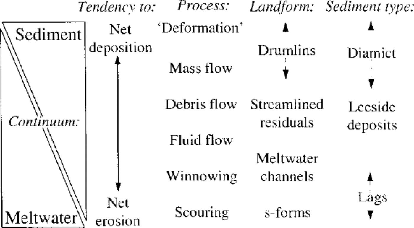
Fig. 6. Characteristics of subglacial sediment/meltwater continuum.
Regional evidence also shows that meltwater activity was an important control on fast ice flow and bedform shaping. The Poyntz Pass tunnel valley, immediately north of the study area (Fig. 1), was a subglacial conduit draining meltwater from the Lough Neagh basin (Reference Dardis and McCabeDardis and McCabe, 1983). Sandy debris-flow deposits within this tunnel valley and the central area of the Lough Neagh basin were drumlinized during southeastward ice streaming during formation of the Killard Point moraine. The switch between phases of ice-stream activity in different areas of east-central Ireland therefore may have been meltwater controlled, along the sediment/meltwater continuum described above (Fig. 6), coupled to changes in the location of the ice margin which determined its sensitivity to changes in RSL and marine downdraw (Reference HughesHughes, 1986; Reference Hicock and FullerHicock and Fuller, 1995). The Castleblaney ice stream may have been “switched off” by shifts in ice-centre location as a result of ice-profile lowering, or by changes in the nature of subglacial drainage such as drainage piracy during headcutting of the Armagh ice stream (i.e. Reference Alley, Anandakrishnan, Bentley and LordAlley and others, 1994). Comparison with late- Pleistocene and contemporary analogues (Reference Blankenship, Bentley, Rooney and AlleyBlankenship and others, 1986; Reference Kaufman, Miller, Stravers and AndrewsKaufman and others, 1993) indicates that these ice streams may have operated for a few hundred years, which is consistent with the available radiocarbon dates (Table 1) and the likely tempo of ice-sheet events in the British Isles (Reference McCabeMcCabe, 1996; Reference McCabe and ClarkMcCabe and Clark, 1998). Bedform evidence for changes in drainage and sediment-transport mechanisms during palaeo-ice stream activity has important implications for qualitative assessment of the controls on the dynamics of current Antarctic ice streams (Reference Blankenship, Bentley, Rooney and AlleyBlankenship and others, 1986; Reference OppenheimerOppenheimer, 1998).
Conclusions
-
1. Patterns of modified Rogen moraines and genetically related marginal sediment sequences show two main phases of ice streaming in east-central Ireland. The Castleblaney ice stream (~15.0 14C kyr BP), which did not have an extensive tidewater margin, was topographically controlled and streamlined some ridge components. The Armagh ice stream (dated indirectly to ~ 13.8 14C kyr BP) experienced strong marine downdraw and was characterized by a vigorous subglacial sediment/meltwater “conveyor” which transported material to the ice margin. Ice streaming was supported mainly by basal sliding and marine downdraw, rather than deformation of subglacial sediments.
-
2. Patterns of bedform modification and marginal sediment sequences show that subglacial drainage mechanisms changed down-ice from discrete channels to unchannelized sheetflows which deepened towards the ice margin during regionally high RSL. Meltwater may have been contributed to the system by release from subglacial cavities and by strain heating at sheared ice- stream margins. Ice-stream activity is probably related to instability at tidewater margins, followed by complex thermal and hydraulic responses within the ice mass.
-
3. The general absence of subglacial sediment within about 25 km of the present coast, and high coeval RSL (+20— 30 m a.s.l.), suggest meltwater availability was an important control on ice-streaming activity and the nature of subglacial bedform modification.
Acknowledgements
We thank M. Millar and K. McDaid for drawing the diagrams, and N. McDowell for photographic processing. Comments by J. A. Piotrowski and D.J. A. Evans and an anonymous reviewer are appreciated.


