


Introduction
The Woore Moraine is a major glacial end moraine forming the eastern end of a larger moraine complex that stretches across the Cheshire Plain, Britain (Fig. 1), and is thought to have been emplaced by a terrestrial lobe of ice from the Irish Sea basin during the late Devensian (Reference Boulton and WorsleyBoulton and Worsley, 1965). Various models have been postulated to account for the moraine’s origin. These involve ice advance (Reference Boulton and WorsleyBoulton and Worsley, 1965; Reference ShottonShotton, 1967a; Reference Yates and MoseleyYates and Moseley, 1967), a stillstand (Reference ShottonShotton, 1967b; Reference Worsley, Ehlers, Gibbard and RoseWorsley, 1991; Reference Catt, Brenchley and RawsonCatt and others, 2006), ice stagnation (Reference Paul and EylesPaul, 1983; Reference GoudieGoudie, 1990), overriding and subsequent modification of a pre-existing landform (Reference Poole and WhitemanPoole and Whiteman, 1961; Reference PoolePoole, 1966, Reference Poole1968) and draping of glacial materials over a bedrock ridge (Reference McQuillinMcQuillin, 1964). Attempts to identify the moraine’s origin and significance have been hampered by its size and the limited information on its surface geomorphology and internal structure. In addition, the moraine has yet to be dated directly.

Fig. 1. Location of the Woore Moraine. (a) Two possible models of the former British–Irish ice sheet at the Last Glacial Maximum. The dashed box demarcates the Cheshire Basin (Reference Clark, Hughes, Greenwood, Jordan and SejrupClark and others, 2012). (b, c) These maps are NEXTMap™ Great Britain enhanced resolution digital elevation model (DEM). (b) Topography within the Cheshire Basin. The Woore Moraine (dashed box) forms the easternmost ridge of the Bar Hill–Whitchurch–Wrexham moraine complex, a double arcuate loop of high ground adjacent to the Southern Pennine Margins. (c) Solar-shaded DEM showing the Woore Moraine and associated glacial landforms.
This paper forms part of a broader study that used a combination of geomorphological mapping, sedimentological analysis and geophysical surveying to constrain the origin of the Woore Moraine. Initial findings associated with the geomorphological mapping are reported in Reference Parkes, Waller, Knight, Stimpson, Schofield and MasonParkes and others (2009). This showed that the moraine forms a broadly arcuate ridge ∼9km long and ∼5 km wide and comprises three distinct landform assemblages. This follow-up paper focuses on the results of geophysical surveying that were used to image the internal structure of the moraine and to identify the constituent facies and large-scale structural features.
Methodology
The combined application of multiple geophysical techniques provides distinct yet complementary information about the moraine’s large-scale internal structure and composition, as well as enabling determination or otherwise of the presence of near-surface bedrock (e.g. Reference McQuillinMcQuillin, 1964). Geophysical techniques employed include ground-penetrating radar (GPR), electrical resistivity tomography (ERT) and seismic refraction. Attempts at multichannel analysis of surface waves (MASW) were largely unsuccessful.
GPR surveys were undertaken using 50MHz antennae which provided the best compromise between depth penetration and resolution for the glacial material at Woore. GPR data were acquired using a Sensors and Software Inc. pulseEKKO 100™ system and stored on a ‘Noggin’ digital video logger. Common-offset profiling was used and GPR data were modelled using Reflex software. Common processing practices were followed (cf. Reference BennettBennett and others, 2004; Reference Sadura, Martini, Endres and WolfSadura and others, 2006; Reference Benediktsson, Schomacker, Lokrantz and IngolfssonBenediktsson and others, 2010), specifically start-time correction, time-cutting, dewowing and automatic gain control. The radargrams were topographically corrected via application of a static time correction using elevation data acquired from both NEXTMap™ data and a Leica differential GPS (DGPS). The signal velocity of 0.08 kms–1 obtained from reflection hyperbolae using Reflex software is consistent with unconsolidated mixed sand and clay (e.g. Reference BennettBennett and others, 2004).
ERT surveys used a Campus Tigre resistivity meter connected via multi-core cable to a maximum of 64 metal electrodes. Based on similar studies across glacial landforms (e.g. Reference Kulessa, Clarke, Hughes, Barbour, Hambrey, Christoffersen, Glasser and HubbardKulessa and others, 2007), an electrode spacing of 5 m was used to provide sufficient depth penetration to detect any potential bedrock. Image Pro 2000 software was used to manage the survey and record the data. Res2Dinv software was used for data modelling (Reference LokeLoke, 2000), with a least-squares inversion algorithm (cf. Reference Kulessa, Clarke, Hughes, Barbour, Hambrey, Christoffersen, Glasser and HubbardKulessa and others, 2007; Reference Kristensen, Benn, Hormes and OttesenKristensen and others, 2009a,Reference Kristensen, Juliussen, Christiansen and Humlumb). The resultant model was topographically corrected. Micro-resistivity data were collected for key facies exposed within shallow excavations using a Megger ground resistivity meter. Four electrodes were placed at 5cm equal spacing in a Wenner array to constrain interpretation of the larger ERT surveys.
Seismic refraction data were collected using a sledgehammer source and up to 24 geophones spaced at 3m intervals connected to a Geometrics Inc. Geode seismic recorder, similar to other surveys of glacial sediments (e.g. Reference Kulessa, Clarke, Hughes, Barbour, Hambrey, Christoffersen, Glasser and HubbardKulessa and others, 2007; Reference Hiemstra, Kulessa, King and NtarlagiannisHiemstra and others, 2008). The source was placed off both ends of the survey line (–34.5 and +103.5 m), on both ends (0 and 69 m) and at the survey midpoint (34.5 m). Seismic data were acquired with a sampling interval of 32.25 ms and a record length of 0.5 s. Refraction data were processed and analysed using Seis-Imager software. The plus–minus method (Reference HagedoornHagedoorn, 1959) was used to determine the refractor depth profile.
Results and Interpretation
Three transects were undertaken, with a combined total survey length of 10.5 km (Fig. 1). Transects 1 and 2 (Figs 2 and 3) were orientated north-south in order to provide large-scale structural information for the moraine’s proximal and distal flanks. Transect 3 (Fig. 4) was orientated east-west so as to profile elongated ridges orientated perpendicular to the moraine’s crest.
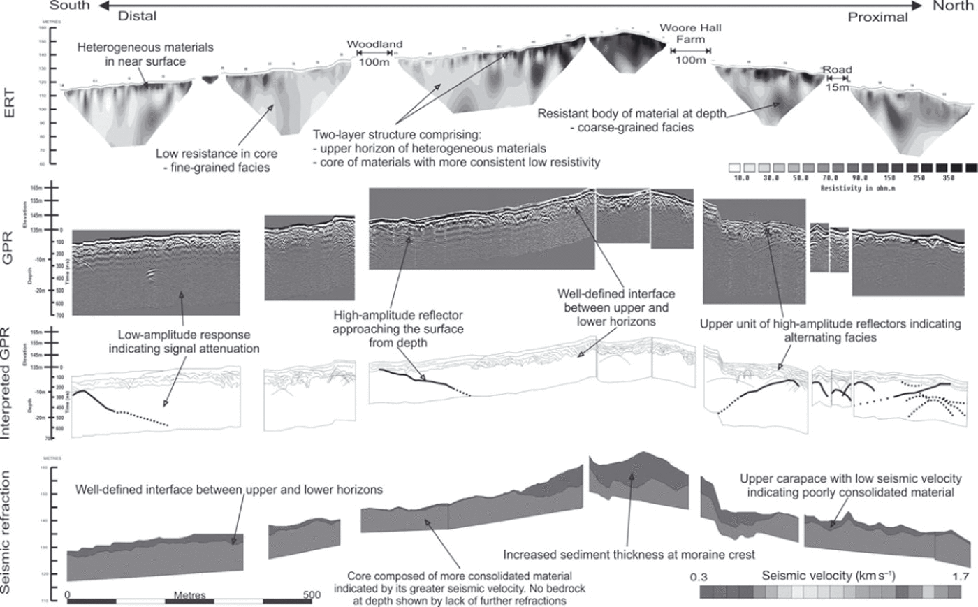
Fig. 2. Geophysical surveys conducted along transect 1 including ERT, GPR (both post-processed data and interpretation) and seismic refraction. Annotations highlight the key structural features identified.
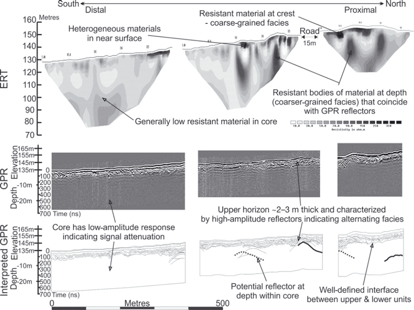
Fig. 3. Geophysical surveys conducted along transect 2 including ERT and GPR (both post-processed data and interpretation). Annotations highlight the key structural features identified.

Fig. 4. Geophysical surveys conducted along transect 3 including ERT, GPR (both post-processed data and interpretation) and seismic refraction. Annotations highlight the key structural features identified.
Electrical resistivity tomography
Micro-resistivity data collected from shallow excavations constrained the interpretation of the dominant facies identified by ERT surveys. Clay/silt-dominated lithofacies at Woore generally have apparent resistivities <50 Ωm. Coarser-grained sand/gravel facies have higher values, with dry sands having the highest resistivities. Using a 5 0 f im cut-off enabled zones within the large-scale ERT surveys to be interpreted as either clay/silt-prone or sand/gravel-prone facies.
The results of the ERT surveys suggest that the Woore Moraine comprises two major units: an upper horizon with marked sedimentological heterogeneity and an underlying core that is more homogeneous in nature. The overlying unit is typically 4-6m thick but reaches a maximum of 10m towards the moraine crest, where very high resistivities suggest a dry sand composition. The core is dominated by low resistivity values of <50 Ωm indicating a dominance of clay/silt materials. Isolated regions of higher resistivity >60 Ωm indicate the localized presence of coarser material.
Ground-penetrating radar
A number of structural features have been identified using GPR. Complex discontinuous high-amplitude reflectors within the carapace represent interfaces between sediments with different physical characteristics, principally grain size (Reference BennettBennett and others, 2004). These reflectors indicate rapidly alternating facies. Within the core of the moraine, isolated high-amplitude reflectors approach the surface from depth. Reflectors distal of the crest dip to the north, while those proximal of the crest dip southwards at shallow angles of 20–408.
Seismic refraction
Seismic refraction data reveal a two-layer structure. An upper horizon, with a low seismic velocity of ∼200-300ms–1, is typically ∼3m thick on the moraine’s flanks and thickens to between 10 and 20 m at the crest. This velocity is similar to values reported by Reference Ismail and SargentIsmail and Sargent (2006) for mixed unconsolidated sediments consisting of both fine- and coarse-grained facies. The absence of refractions from depth within the core indicates that the upper horizon is underlain by glacial sediments a minimum of 55 m thick and that there is no bedrock core to the structure (cf. Reference McQuillinMcQuillin, 1964). The seismic velocity of the moraine’s core is 1600-2000 ms–1, which is inconsistent with Mercia Mudstone Group bedrock (cf. Reference Francis, Millwood Hargrave, Mulholland, Williams, Meadows, Trueblood, Hardman and CowanFrancis and others, 1997).
Synthesis
The Woore Moraine’s two-layer structure is similar to that observed within overridden moraines (Reference TottenTotten, 1969). Two units are clearly distinguishable in all geophysical datasets as they display highly contrasting geophysical properties. The two units are separated by an undulating well-defined interface, suggesting that it is an unconformity.
The upper horizon of the Woore Moraine is interpreted as a carapace of mixed glacigenic sediments. GPR high-amplitude reflectors indicate rapidly changing facies exhibiting varying degrees of disturbance. The unit is present across the entire moraine and is extremely heterogeneous in nature, with ERT indicating a mixture of clay/silt and sand/gravel facies. Sand and gravel appear to dominate the moraine’s crest and the superimposed ridges, whereas the flanks of the moraine are richer in clay/silt material.
The core of the moraine has a much more consistent large-scale structure than the upper carapace. ERT data indicate that it consists principally of clay/silt material, as shown by its low resistivity, typically 20-40 Ωm, with occasional zones of higher resistivities. Similarly, GPR shows that the moraine’s core is generally characterized by a lack of continuous high-amplitude reflectors, indicative of high signal attenuation, a phenomenon commonly associated with fine-grained facies such as clay and silt (Reference Schrott and SassSchrott and Sass, 2008). Seismic velocities within the core vary between 1600 and 2000 ms–1, also consistent with consolidated clay.
Discrete reflectors within the core are interpreted as thrusts, based on a trench section excavated across the site where one of these features approaches the surface. This trench shows glacial diamicton thrust over fluvioglacial sands (Reference ParkesParkes, 2010). These deeper structures are northward-dipping on the south flank, fore-thrusting relative to the assumed direction of former ice-flow bulldozing, and southward-dipping, back-thrusting, on the north. These thrusts form a structural ‘pop-up’ feature (Reference ParkPark, 1997).
Discussion
Origin of the Woore Moraine
Geophysical techniques have revealed that the Woore Moraine’s internal structure and geomorphology are consistent with a polygenetic origin, specifically glaciotectonic deformation (thrusts) and overriding (overlying carapace), with input of material via accumulation processes from the nearby glacier margin (sands/gravels at the moraine’s crest). This indicates that the moraine was emplaced by an active glacier lobe that underwent several phases of advance and retreat. The moraine does not show large-scale evidence for ice stagnation (cf. Reference Paul and EylesPaul, 1983; Reference GoudieGoudie, 1990) or a near-surface bedrock ridge (cf. Reference McQuillinMcQuillin, 1964).
Polygenetic moraine formation reflects the dynamic nature of ice-marginal environments, which are characterized by a range of both glacial and glacially associated processes (Reference KnightKnight, 1999), as well as periglacial processes (Reference Harris, Tweed and KnudsenHarris and others, 2004). Recent studies have recognized that even relatively simple moraine forms are likely to have been emplaced by multiple processes (e.g. Reference Winkler and MatthewsWinkler and Matthews, 2010).
The Woore Moraine’s structure shows that formation occurred in two distinct phases, with initial emplacement of the core and later the upper carapace separated by an erosional unconformity. The lower clay-rich part of the moraine core was initially formed as a subglacial till during the main advance of the ice lobe. As the ice sheet retreated across the Cheshire Plain, the clay-rich diamicton was covered with a layer of proglacial sands and gravels. Subsequent readvance of the ice sheet bulldozed this sequence, thickening it via fore- and back-thrusts. The moraine was then overridden, either during the same readvance or a subsequent episode. This generated the unconformity and the overlying carapace (Fig. 5).
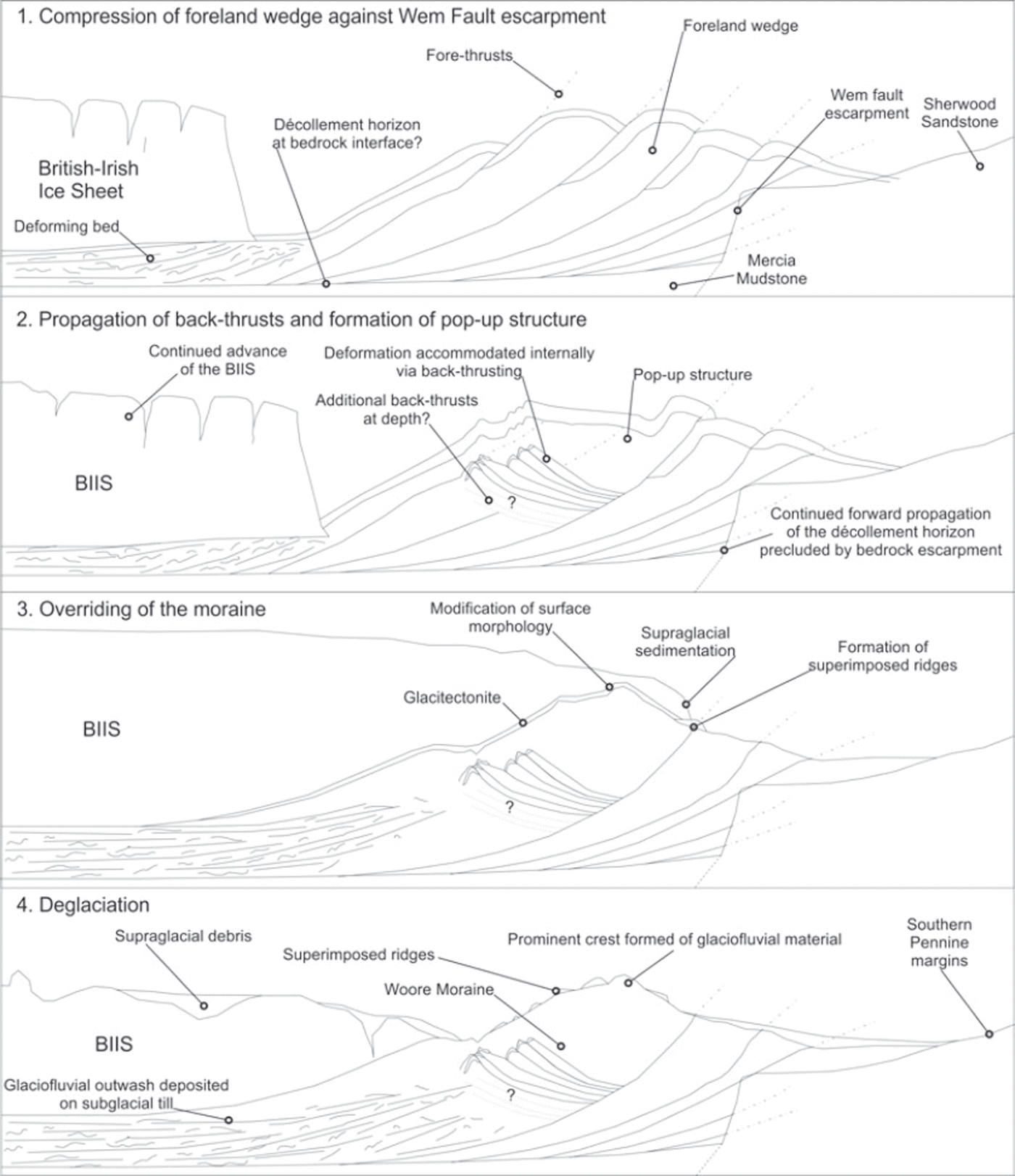
Fig. 5. Schematic cross sections illustrating the potential mechanisms of the Woore Moraine’s emplacement through time. Formation relates to an advance of the British–Irish ice sheet (BIIS) that deformed pre-existing glacial sediments by fore- and back-thrusts. The moraine was subsequently modified by overriding, which developed a glaciotectonic carapace and associated superimposed landforms.
The location of the moraine could have been influenced by the underlying geology, as its position is coincident with the subcrop of the Wem Fault that separates Triassic Mercia Mudstone Group rocks to the north from Sherwood Sandstone Group to the south. The underlying geology could have led to formation of the pop-up structure in two ways. Ice-bulldozed glacigenic sediments could meet greater basal friction over the more permeable sandstones (Reference BennettBennett, 2001); however, a more likely alternative is that the sediments could be buttressed by a topographical step at the fault from down-thrown less resistant mudrocks to more elevated resistant sandstones.
Application of geophysical techniques within relict glacial environments
Away from coasts, formerly glaciated regions commonly lack significant exposures. As a consequence, there has been little work in these regions, which remain poorly understood. Many studies within relict glacial environments have therefore focused on reconstructing former glaciers solely on the basis of geomorphological evidence (e.g. Reference Clark, Hughes, Greenwood, Jordan and SejrupClark and others, 2012). Recognition of polygenetic landforms (Reference Harris, Tweed and KnudsenHarris and others, 2004; Reference Winkler and MatthewsWinkler and Matthews, 2010) indicates that interpreting the origin based on geomorphological evidence alone can lead to misinterpretation of a landform’s genesis and its broader significance (Reference EvansEvans, 2003).
Reference Worsley and LewisWorsley (1970) advocated the application of geophysical techniques to determine the internal structure of poorly exposed glacial landforms. However, until recently, the uptake and application of geophysical techniques for investigation of relict glacial environments has been limited. GPR is most commonly used, usually as a stand-alone technique to identify structural features (Reference BakkerBakker, 2004). However, many geophysical techniques are available which, when used in combination, can provide a more detailed and robust model of the origin of glacial landforms. Excavations can then be used to constrain geophysical data, facilitating more accurate interpretation.
This project has shown that systematic use of multiple geophysical techniques is the best alternative to more conventional analyses when investigating a landform lacking significant surface exposures. Geophysical techniques are capable of determining the large-scale structure of a land-form and facies distribution in three dimensions, even in the absence of other subsurface data (Reference Kulessa, Clarke, Hughes, Barbour, Hambrey, Christoffersen, Glasser and HubbardKulessa and others, 2007). Individual techniques are associated with some limitations principally related to unfavourable ground conditions, compromise between resolution and depth of penetration, and due to difficult imaging conditions associated with rapid lateral and vertical facies changes, changing levels of pore-water and compaction at depth (Table 1). Such limitations can be overcome by applying multiple techniques, as advocated by Reference Schrott and SassSchrott and Sass (2008). Further, the interpretation of combined geophysical data is more robust as the understanding is based on multiple sources of evidence (Reference Kulessa, Clarke, Hughes, Barbour, Hambrey, Christoffersen, Glasser and HubbardKulessa and others, 2007; Reference Hambrey, Quincey, Glasser, Reynolds, Richardson and ClemmensHambrey and others, 2008).
Table 1. Application of various geophysical techniques within glacial environments
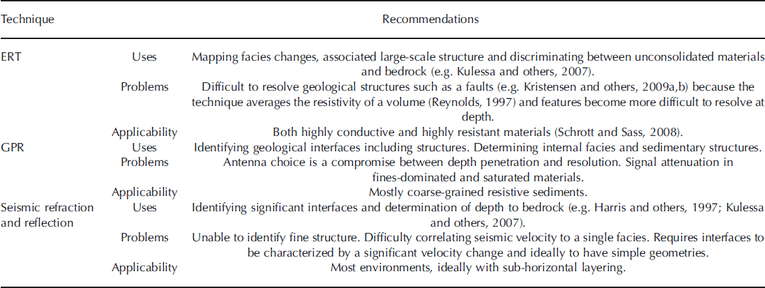
Three complementary geophysical techniques were employed in this study and have demonstrated their potential in constraining the origin of the Woore Moraine. ERT mapped large-scale facies changes and these data were complemented by structural data obtained via GPR. Seismic refraction determined the depth to the interface between the carapace and underlying core and also showed that there was no bedrock ridge at shallow depths beneath the moraine’s crest (cf. Reference McQuillinMcQuillin, 1964).
Our experiences in deploying multiple geophysical techniques in surveying the Woore Moraine lead to a generalized approach for investigation of glacial landforms. First, geomorphological mapping enables key landforms and landform assemblages to be identified. Reconnaissance surveying allows determination of the spatial distribution and potential composition of glacial facies prior to time-consuming extensive geophysical surveying. This enables selection of appropriate techniques and equipment, as well as determination of survey parameters such as geophone/electrode/antenna spacing for optimum resolution and penetration of the sequences that are likely to be encountered. Where possible, the reconnaissance surveying should take place close to an exposure, borehole or excavation to calibrate the geophysical responses to the local geological materials. ERT proves to be a good tool for reconnaissance surveys, as resistivity values can be related to published data to provide an indication of the landform’s composition and structure (e.g. Reference Kristensen, Benn, Hormes and OttesenKristensen and others, 2009a,Reference Kristensen, Juliussen, Christiansen and Humlumb).
Micro-resistivity measurements made directly in exposures constrain mapping of facies, but published resistivity ranges for specific sediments (e.g. Reference Palacky and NabighianPalacky, 1987) are suitable for more generalized interpretation of ERT data and for determining the likely sedimentary composition (Reference Parkes, Waller, Knight, Stimpson, Schofield and MasonParkes and others, 2009). This in turn can assist in determining the applicability of other geophysical approaches, including GPR and seismic techniques. For example, mapping of extensive clay/silt-prone regions would indicate that seismic techniques, such as seismic reflection, might be more useful than GPR as fine-grained sediments cause attenuation of radar signal.
At Woore, the most useful combination of geophysical techniques was ERT and GPR because both structural features and the likely facies compositions could be determined (e.g. Reference Hambrey, Quincey, Glasser, Reynolds, Richardson and ClemmensHambrey and others, 2008).
Conclusions
Geophysical surveying is perhaps the most suitable alternative to conventional approaches for investigating the origin of landforms lacking exposure as it enables determination of internal facies distributions and structure. The combined application of complementary multiple geophysical techniques is essential when investigating relict glacial environments because of their complex nature. For the Woore Moraine, ERT was able to map large-scale facies changes, GPR identified structural features, and seismic refraction surveying highlighted the unconformable boundary between the moraine core and upper carapace, while demonstrating the absence of near-surface bedrock. MASW was less successful in generating stiffness profiles due to the quiet rural nature of the site.
Undertaking reconnaissance surveys prior to extensive surveying was useful to determine the potential distribution of facies within the environment. Furthermore, it allowed informed decisions to be made regarding geophysical survey parameters that govern the compromise between resolution and depth penetration. Shallow excavations and associated micro-resistivity surveys targeting features identified by the geophysics allowed the resulting interpretations to be constrained more accurately.
The approach adopted for the Woore Moraine, involving geophysical surveying using multiple complementary techniques combined with systematic landform mapping and selected excavation with sedimentological analysis of geophysical targets, works well in environments characterized by limited exposure. Such environments form a significant area of formerly glaciated regions that consequently remain little studied and poorly understood.
This study has demonstrated that the Woore Moraine is a polygenetic landform. Its internal structure consists of a moraine core comprising subglacial clay-rich diamicton deposited during the main ice advance across the Cheshire Plain, overlain by fluvioglacial outwash sands deposited during subsequent ice retreat. These are deformed by a series of fore- and back-thrusts forming a pop-up structure generated by a subsequent readvance. An upper carapace comprising more heterogeneous glacial sediments that become thicker and more sand-rich towards the moraine crest unconformably overlies the moraine core. This is associated with overriding and subglacial modification of the existing moraine during ice readvance. The close association of the Woore Moraine with the subcrop of the Wem Fault suggests a geological control on its development. The prominent fault scarp is likely to have acted as a physical obstacle to the propagation of material at the advancing margin, precluding continued fore-thrusting and resulting in the formation of back-thrusts, and contributing to the vertical development of the moraine as a whole.
Acknowledgements
We gratefully acknowledge the financial support of Keele University’s Research Institute for the Environment, Physical Sciences and Applied Mathematics (EPSAM), which funded A.A. Parkes’ studentship, as well as the logistical support and training provided by the Applied Environmental Geophysics Group. Additional funding to support the fieldwork was provided by the Royal Geographical Society (with the Institute of British Geographers) via a Postgraduate Research Award. Access to the NEXTMap™ Great Britain data was provided by the British Geological Survey. We also thank all the landowners who provided access to their land: Jane and Steve Ellsmoor of Dorrington Hall Farm, Paul Platt of Woore Hall Farm, Tony Swires of Cottage Fields Farm, Yvonne and Mark Braithwaite of Gorsey Bank Cottage and Jon Sutton of Oak Farm.


