


Introduction
Ponds that form on sea ice are important for the energy balance of the sea ice and the polar oceans. Sea ice ponds alter the light scattering properties of the ice surface and lower its albedo (Perovich and others, Reference Perovich, Grenfell, Light and Hobbs2002; Grenfell and Perovich, Reference Grenfell and Perovich2004). As the lower albedo causes the ice to absorb more solar energy, a positive feedback between melting and ponding can develop (Curry and others, Reference Curry, Schramm and Ebert1995), and enhanced melting of sea ice can cause it to thin or break-up (Perovich and others, Reference Perovich2003; Arntsen and others, Reference Arntsen, Song, Perovich and Richter-Menge2015). Landfast sea ice and ice mélange buttress ice shelves and provide a protective buffer from ocean swells that can weaken ice-shelf fronts. Consequently, ice shelves are more prone to calve or disintegrate when landfast sea ice breaks-up or thins (Banwell and others, Reference Banwell2017; Robel, Reference Robel2017; Massom and others, Reference Massom2018).
In the Arctic, observations show that when snow and ice on the surface of sea ice melts and the meltwater accumulates in depressions, sea ice ponds form (Polashenski and others, Reference Polashenski, Perovich and Courville2012). In the Antarctic, although ponds may form on the sea ice when snow weighs it down and causes seawater to flood its surface (NSIDC, 2019), scientists have rarely observed the presence of ponds formed from meltwater (Andreas and Ackley, Reference Andreas and Ackley1981; Perovich, Reference Perovich1996) because there is minimal surface melt on Antarctic sea ice (Vihma and others, Reference Vihma, Johansson and Launiainen2009).
However, recent studies have documented an additional phenomenon that we suggest could be a mechanism for the formation of sea ice ponds. Surface meltwater streams on ice shelves in both Greenland (Macdonald and others, Reference Macdonald, Banwell and MacAyeal2018) and Antarctica (Bell and others, Reference Bell2017) have been observed to flow over the ice-shelf front. Macdonald and others (Reference Macdonald2019) note that during the melt season, ponds form on sea ice adjacent to the McMurdo Ice Shelf (McMIS), Antarctica. We show that sea ice ponds can form when surface meltwater runoff from an Antarctic ice shelf flows over the ice-shelf front onto the sea ice, possibly with significant implications for sea-ice stability.
Here, we document and analyze the formation and evolution of sea ice ponds in McMurdo Sound, adjacent to the McMIS, over the austral summers of 2015–16 to 2018–19. We do this qualitatively, by analyzing satellite image data over the period, and quantitatively, by using a water-identification algorithm to measure the evolution of the ponded area.
Study site
The McMIS is a ~1500 km2 ice shelf, located in the northwest corner of the Ross Ice Shelf at 78° S. It abuts the southern tip of Ross Island where the US McMurdo Station and New Zealand Scott Base are located (Fig. 1). The ice shelf is relatively thin close to its front (10–30 m; Rack and others, Reference Rack, Haas and Langhorne2013; Campbell and others, Reference Campbell, Courville, Sinclair and Wilner2017) and its front faces McMurdo Sound, which is typically covered by landfast sea ice through the summer. February 2016 and February 2019 are the most recent instances of the sea ice breaking-out. Where sea ice is present at the ice-shelf front, it appears to inhibit calving from the ice shelf. The breakout of sea ice at the ice-shelf front in 2016 was associated with calving of icebergs from the ice shelf and the propagation of a rift by ~3 km on the ice shelf (Banwell and others, Reference Banwell2017).
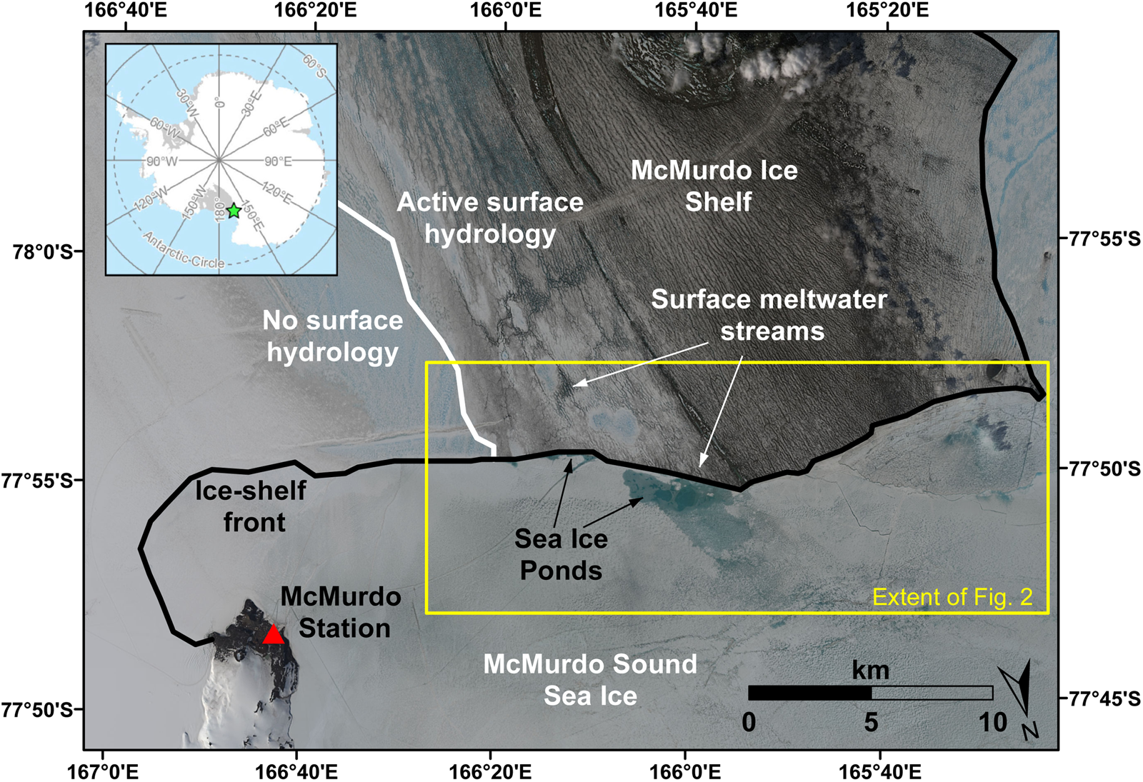
Fig. 1. Part of the McMIS and McMurdo Sound sea ice (green star in top-left inset shows location in Antarctica). The background image is a true-color composite Sentinel-2B image dated 4 January 2019. The white line marks the boundary between the portion of the McMIS where there is an active surface hydrology during the summer, and the portion where there is typically no surface hydrology. The black line marks the boundary between the ice shelf and sea ice. The yellow box marks the study area and extent of the images in Figure 2. Sea ice ponds are visible close to the ice-shelf front adjacent to the ‘active surface hydrology’ portion of the McMIS.
The western portion of the McMIS is heavily covered by debris, primarily due to the redistribution of sediment from the Black Island Medial Moraine (Glasser and others, Reference Glasser, Goodsell, Copland and Lawson2006, Reference Glasser, Holt, Fleming and Stevenson2014). Largely due to the effect of the debris on the energy balance of the surface (Glasser and others, Reference Glasser, Goodsell, Copland and Lawson2006), during the summer the McMIS has an active surface (and subsurface) hydrology in its western portion (MacAyeal and others, Reference MacAyeal2018), where lakes and surface streams form (Banwell and others, Reference Banwell, Willis, Macdonald, Goodsell and MacAyeal2019; Macdonald and others, Reference Macdonald2019; MacAyeal and others, Reference MacAyeal, Willis, Banwell, Macdonald and Goodsell2020). These surface streams are forced to divert around ‘pedestalled relict lake’ features – high-albedo, hydrologically-isolated features that are raised above their immediate surroundings and form at the site of former surface lakes (Macdonald and others, Reference Macdonald2019). To the east of the ‘active surface hydrology’ portion of the ice shelf is an area where there is typically subsurface water but not surface water. Further east of this is a dry snow zone (Klokov and Diemand, Reference Klokov and Diemand1995; Macdonald and others, Reference Macdonald2019). We focus our analysis in and around the area where ponds form on the sea ice abutting the ‘active surface hydrology’ part of the ice shelf (Fig. 1).
Data & methods
We acquired a time series of completely or partially cloud-free Landsat 8 and Sentinel-2 images over the study site (Fig. 1) for the period from 29 November 2015 to 24 January 2019 (Table S1). This period covers the entire lifecycle of the McMurdo Sound multi-year sea ice that formed in 2016 and broke-out in 2019, and the sea ice that only lasted for the 2015–16 season.
First, we analyzed how the sea ice ponds form and evolve by visually inspecting the true-color satellite images, with a particular focus on the study site area (Fig. 1).
Second, to quantify the evolution of sea ice ponds, we used the normalized difference water index adapted for ice (NDWIice) method (see Supplementary Material). The method uses the red and blue bands for both types of satellites to identify water-covered pixels, from which we calculated the ponded area on the sea ice at our study site for all quality images. Substantial gaps in the availability of quality images during the study period prevent the calculation of ponded area for some stretches of the study period, limiting the temporal resolution of the study and introducing uncertainty about the timing and magnitude of ponding.
Observations & discussion
We show that meltwater from the McMIS flows off the ice shelf and onto the adjacent sea ice, forming sea ice ponds that we suggest may affect the stability of the sea ice. This process is a previously undocumented mechanism for the formation of sea ice ponds. In each of the four melt seasons studied, ponds first begin to develop on the sea ice immediately adjacent to the ice-shelf front in late November or early December, before expanding in number and area over the following weeks (Figs 2 and 3; Video S1). The ponds typically expand along the ice-shelf front, although in 2018–19 some meltwater spills out of this area and a pond expands to ~4 km from the ice-shelf front. Ponds form on the sea ice directly adjacent to the ice-shelf front, in the part that abuts the ‘active surface hydrology’ zone of the ice shelf (Glasser and others, Reference Glasser, Goodsell, Copland and Lawson2006; Banwell and others, Reference Banwell, Willis, Macdonald, Goodsell and MacAyeal2019; Macdonald and others, Reference Macdonald2019). Throughout the study period, ponds do not form beyond an eastern limit, which corresponds to the boundary on the ice shelf between the zone of ‘active surface hydrology’ and ‘no surface hydrology.’ This supports our suggestion that the ponds are derived from ice-shelf surface meltwater runoff. Additionally, ponds do not form adjacent to a ~1 km wide high-albedo section in the ‘active surface hydrology’ zone of the ice shelf, which is likely a pedestalled, relict lake. This high-albedo area can be expected to undergo less surface melting, and it forms a topographic obstacle to surface streams (Macdonald and others, Reference Macdonald2019).
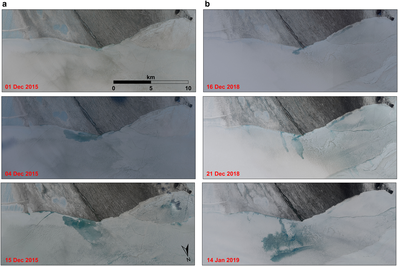
Fig. 2. The development of sea ice ponds adjacent to the ‘active surface hydrology’ portion of the McMIS in the (a) 2015–16 and (b) 2018–19 austral summers. The extent of each image is shown in Figure 1. The complete time series of all 32 images acquired from 29 November 2015 to 24 January 2019 can be seen in Video S1.
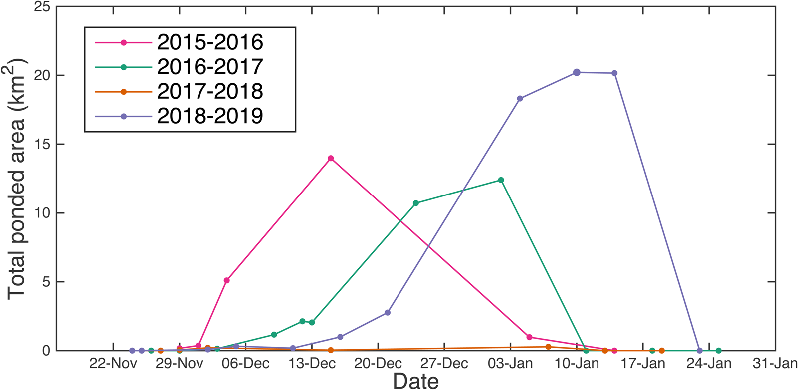
Fig. 3. Total ponded area in the study area during each melt season of the study period (2015–16 to 2018–19).
The sea ice ponds that we observe are large. The total ponded area reaches a peak of 14.0, 10.7 and 20.2 km2 in 2015–16, 2016–17 and 2018–19, respectively (Fig. 3). In each case, the majority of the ponded area at its peak is contained within a single large pond. In 2017–18, the peak ponded area reaches only 0.3 km2. The date that peak area is reached in each year ranges from 15 December to 10 January. Additionally, the ponds can grow rapidly. For example, between 1 and 4 December 2015, the total ponded area grows from 0.4 to 5.1 km2 (Figs 2a and 3). The ponds expand and merge, and can reach areas substantially larger than that of typical sea ice ponds in the Arctic which have diameters of several meters to several tens of meters (Yackel and others, Reference Yackel, Barber and Hanesiak2000; Hohenegger and others, Reference Hohenegger, Alali, Steffen, Perovich and Golden2012; Petrich and others, Reference Petrich2012; Popović and others, Reference Popović, Cael, Silber and Abbot2018). For example, on 15 December 2015, a single consolidated pond reaches an area of ~9.0 km2 (Fig. 2). This suggests that surface meltwater runoff from ice shelves provides a mechanism to create significantly larger sea ice ponds than otherwise develop. Previous research has suggested that there is typically an upper-limit on sea ice pond coverage fraction because common flaws in the ice (e.g. cracks, seal holes) limit pond expansion (Polashenski and others, Reference Polashenski, Perovich and Courville2012, Reference Polashenski2017; Popović and others, Reference Popović, Silber and Abbotin review). As such a limit does not appear to prevent the development of large ponds adjacent to the ice-shelf front, it seems that the specific conditions that exist in the sea ice there enable large ponds to form by restricting the formation of cracks and flaws in the ice. We speculate that these conditions could be associated with a buttressing effect from the contiguous ice shelf, but more research would be required to determine the exact cause of this phenomenon.
Eventually, as we determine from manual visual interpretation of the imagery, the ponds freeze-over. At first, a pond may be covered by a thin, transparent ice-lid, and later, by a thicker, white ice-lid and/or snow-cover that masks the meltwater below. We observe evidence of freeze-over as early as 15 December, and this can occur at one pond while others continue to expand.
Ponds can influence the surface hydrology of the sea ice in the following year after they freeze-over. On 24 November 2018, before pond formation begins, a frozen-over pond that froze-over at the end of the preceding summer is still visible (Fig. S1). By 21 December 2018, an open-water pond is visible at this same site. Although it is common for sites to be ponded in multiple years, this is the only clear instance of a particular pond freezing-over and maintaining its form into the following season. Notably, it is at this site (along with one other site to the west; Fig. 2b) where meltwater spills away from the ice-shelf front and causes the pond to expand into an area of the sea ice ~4 km away from ice-shelf front (Fig. 2b; Fig. S1). It is unclear why the meltwater spills away from the ice-shelf front in this instance.
Although Banwell and others (Reference Banwell2017) suggest that the proximal cause of the 2016 sea-ice breakout event in McMurdo Sound was sea swell, ponding could contribute to sea-ice breakout. In addition to promoting sea-ice thinning by lowering the albedo (Perovich and others, Reference Perovich2003; Arntsen and others, Reference Arntsen, Song, Perovich and Richter-Menge2015), the formation of these ponds could flex the ice, affecting the stability of the sea ice at the ice-shelf front. Typical sea ice ponds develop from meltwater that forms and pools in situ (Polashenski and others, Reference Polashenski, Perovich and Courville2012). Therefore, in those cases the formation of a pond does not result in any additional mass at the site. However, we show that meltwater is added from an external source (the ice shelf) to the sea ice. As has been modeled (MacAyeal and Sergienko, Reference MacAyeal and Sergienko2013; Banwell and MacAyeal, Reference Banwell and MacAyeal2015) and observed (Banwell and others, Reference Banwell, Willis, Macdonald, Goodsell and MacAyeal2019) on ice shelves, when meltwater flows into depressions to form ponds, the added gravitational load of the water causes the ice to depress and flex at the site of the pond. This flexure stresses the ice, and can potentially cause it to fracture. Fracturing of the sea ice increases the chance that it will break-up and break-out (Arntsen and others, Reference Arntsen, Song, Perovich and Richter-Menge2015). Additionally, because the ponds are located directly adjacent to the ice-shelf front, any fracturing or thinning they cause could be particularly important for the sea ice's influence on the ice-shelf front. Fracturing or thinning here could disrupt the sea ice's ability to buttress the ice-shelf front by detaching it from the ice shelf.
Previous observations suggest that sea-ice breakout promotes calving and rifting on the ice shelf. For example, the breakout of sea ice in March 2016 was associated with the calving of numerous icebergs and the extension of an ice-shelf rift (Banwell and others, Reference Banwell2017). Meltwater runoff from the ice shelf could, therefore, lead to ice-shelf mass loss in two ways, by: (i) direct loss of meltwater runoff and (ii) forming ponds on the sea ice that promote sea-ice thinning/break-up, thereby reducing/removing the sea ice's ability to buttress the ice-shelf front and buffer it from ocean swells, promoting calving.
Presently, we only observe the formation of these ice-shelf derived ponds on sea ice adjacent to the McMIS. This could be due to several factors. First, the conditions for meltwater to flow over the ice-shelf front only exist at a limited number of ice shelves due to a combination of climatic factors and factors pertaining to the surface conditions of the ice shelf. Second, katabatic winds that flow at the margins of Antarctica can play a role in blowing sea ice away from the ice-shelf front, preventing it from being present directly adjacent to ice shelves (Bromwich, Reference Bromwich1989). Third, the McMIS is a relatively thin ice shelf, with a thickness near our study site of ~10–30 m (Campbell and others, Reference Campbell, Courville, Sinclair and Wilner2017). Consequently, there is a gentle, sloped transition between the ice shelf and the sea ice that water can flow over. In contrast, at the Nansen Ice Shelf, which is ~200 m thick close to its terminus (Dow and others, Reference Dow2018), Bell and others (Reference Bell2017) observed water flowing as a waterfall over a steep cliff. We suggest that in this case, particularly if the sea ice below is first-year ice, the ice-shelf runoff could break-through the sea ice instead of forming ponds.
However, this new mechanism of sea ice pond formation from ice-shelf meltwater runoff is likely to become a more important factor in the future. Meltwater is predicted to become increasingly pervasive on ice shelves with future climate change (Trusel and others, Reference Trusel2015; Bell and others, Reference Bell, Banwell, Trusel and Kingslake2018). As more meltwater runoff flows over ice-shelf fronts, more and larger ponds could form adjacent to more ice shelves and other marine-terminating glaciers. More work is required to understand what governs the formation of sea ice ponds from ice-shelf runoff, and how they affect sea-ice stability at the ice-shelf front. As this mechanism for sea ice pond formation becomes more prevalent, it could become a significant factor in determining ice-shelf stability at multiple sites around Antarctica.
Conclusion
This study analyses a previously-undocumented mechanism for the formation of sea ice ponds on sea ice in Antarctica. We show that, during the austral summer, meltwater runoff from the McMIS flows over the ice-shelf front and forms large ponds on the adjacent sea ice. These ponds are distinct from those typically observed in the Arctic that form from in situ melting. Because these ponds form by adding mass to the sea ice, they could destabilize the sea ice by flexing it, as well as by reducing the albedo. Although ponds formed by this mechanism have only been found adjacent to the McMIS, they could become more prevalent around Antarctica as melting on ice shelves increases due to climate change.
Supplementary material
The supplementary material for this article can be found at https://doi.org/10.1017/aog.2020.9.
Acknowledgements
This work was supported by the U.S. National Science Foundation grant PLR-1443126. We thank Alison Banwell, Douglas MacAyeal, Ian Willis and Alexander Robel for helpful discussions. We thank Jeff McMahon, and all members of the NSF-supported (#DGE-1735359) science-writing class he led, for comments on the manuscript. GJM (NNX15AN44H) and PP (NNX16AO07H) acknowledge support from NASA Earth & Space Science Fellowships. The free, open-source GIS package, QGIS, and the Norwegian Polar Institute's Quantarctica package, were valuable resources. Finally, we thank the Scientific Editor, David Babb, and two anonymous reviewers whose helpful comments enabled us to improve the paper.


 Open access