


Introduction
Numerical climate models require certain global data as boundary conditions. In the first phase of climate modelling using atmospheric general circulation models (ACGMs) in the 1970s, climate experiments generally involved a modern “control” run and a perturbation experiment, analyzing the model's equilibrium response to some change in boundary conditions or model physics. The latter might include a dry atmosphere, prescribed vs prognostic clouds, or varying lapse-rate parameterization. The former category included changing continental geography (Reference Barron, Sloan and HarrisonBarron and others, 1980), incorporating ice sheets, introducing a stratospheric volcanicaerosol layer, modifying sea-ice limits or land-surface cover, and albedo (Reference BarryBarry, 1975). First generation AGCMs were used by several groups to perform experiments with ice age boundary conditions (Reference Williams, Barry and WashingtonWilliams and others, 1974; Reference GatesGates, 1976; Reference Manabe and HahnManabe and Hahn, 1977). These studies involved the development of maps with changed continental boundaries, land and sea-ice extent, sea-surface temperatures and surface albedo. The CLIMAP project for the Last Glacial Maximum and the COHMAP project for conditions between 18 000 years BP and present, at 3000 year intervals, are important examples of such boundary-condition mapping programs for model input purposes. In parallel with these attempts at the reconstruction of specific paleo-climates, the effects on the atmosphere of imposed changes in the extent of snow cover (Reference WilliamsWilliams, 1975) and of sea ice (Reference Herman and JohnsonHerman and Johnson, 1978) were simulated.
The second generation of GCMs from the mid 1980s generally incorporated higher-resolution and improved model physics. They could treat atmosphere–ocean interactions, for example (Reference Meehl and TrenberthMeehl, 1992); the representation of ocean processes ranges from a simple “swamp” ocean, with no heat storage or ocean currents, to a “slab” mixed-layer ocean where sea-surface temperatures are determined from the surface-energy balance and heat storage, or a coupled ocean GCM that incorporates energy transfers and ocean dynamics (Reference Manabe, Spelman and StoufferManabe and others, 1992).
There is an extensive literature on the use of coupled atmospheric–swamp-ocean and slab-ocean mixed-layer models for climate sensitivity studies. This second phase of GCM developments also witnessed the beginning of transient experiments, for 100 years or more, in genuine climate-change studies of increasing greenhouse-gas concentrations. Second-generation model studies that address the cryosphere are primarily experiments to assess CO2 doubling sensitivity, where it rapidly becomes evident that thermodynamic and dynamic processes need to be treated, and that many variables, other than surface albedo, require parameterization (Reference Meehl and WashingtonMeehl and Washington, 1990). Specific studies of the importance of cryospheric parameterizations were also performed, particularly in view of the role of snow- and ice-albedo feedbacks in climate sensitivity to forcing (Reference Ingram, Wilson and MitchellIngram and others, 1989; Reference OglesbyOglesby, 1990; Reference Cohen and RindCohen and Rind. 1991).
The third generation of fully coupled GCMs are beginning to link the atmosphere–ocean–cryosphere–terrestrial biosphere in fully-coupled treatments (Reference Broccoli, Manabe and PeltierBroccoli and Manabe, 1993), and to incorporate biogeochemical transfers. Land-surface schemes are being intercompared (Reference Henderson-Sellers, Vang and DickinsonHenderson-Sellers and others, 1993), but so far similar work for the cryospheric variables is lacking. Nesting of high-resolution mesoscale models in an atmospheric GCM is increasingly used to address regional processes, including orographic precipitation (Reference Giorgi, Bates and NiemanGiorgi and others, 1993) and marginal sea-ice zone processes (Reference Walsh, Lynch, Chapman and MusgraveWalsh and others, 1993; Reference Lynch, Chapman, Walsh and WellerLynch and others, 1995).
A further development is the improved parameterization of variables such as snow and ice albedo in both process models (Reference Ebert and CurryEbert and Curry, 1993) and in GCMs (Reference BarryBarry, 1996), as well as the detailed treatment of ice dynamics in sea-ice models, including leads, ridging and ice drift (Reference Hibler, Flato and TrenberthHibler and Flato, 1992; Reference Mellor, Häkkinen, Johannessen, Muench and OverlandMellor and Häkkinen, 1994). Their are GCM sensitivity studies that update earlier analyses for the effects of leads (Reference VavrusVavrus, 1995), and sea-ice extent and thickness (Reference Rind, Healy, Parkinson and MartinsonRind and others, 1995). These illustrate the increasing need for cryospheric data and highlight the gaps in current archives (Table 1).
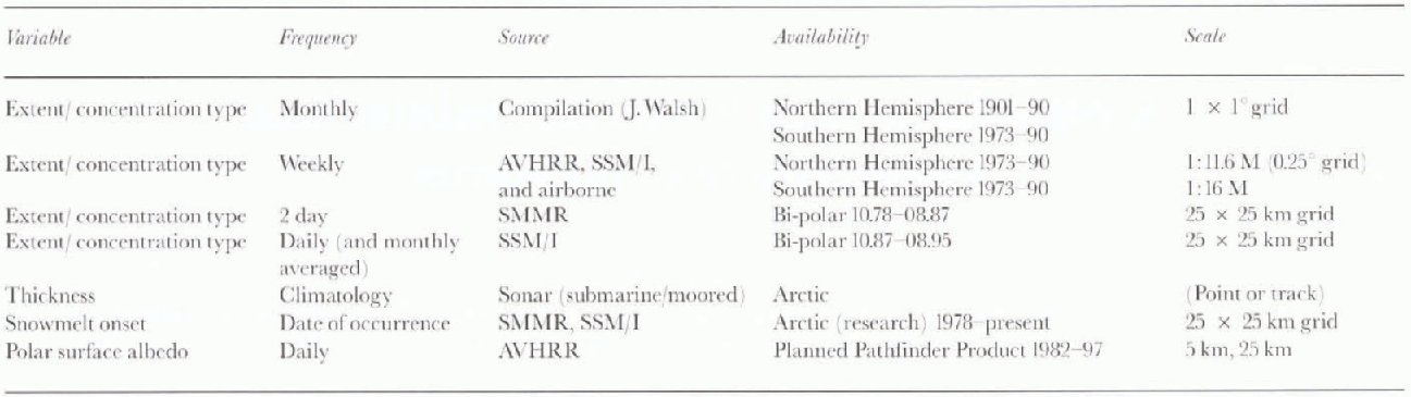
Table 1. Global sea-ice variables and their availability
Data Requirements
Requirements for cryospheric data have recently begun to receive attention from several standpoints. In 1980, the Snow Watch Group identified the requirements for GCMs in terms of basic global maps of snow and ice extent, which until then were mostly in map form, or in the case of snow-depth climatology were thought to be unavailable (Reference HahnHahn, 1981). Reports of the World Climate Programme (Reference JenneJenne, 1982) set out basic data required for model verification and process studies, and these have been subsequently considerably refined and expanded (see Reference CraneCrane, 1993; WMO/Uncsco/UNEP/ICSU, 1995). A comparable effort focusing on modelling needs is desirable (see recommendations in Reference Barry, Goodison and LeDrewBarry and others, 1993), but is beyond the scope of this paper.
Cryospheric Datasets
The primary emphasis here is on hemispheric or global datasets that are available digitally and in gridded form, suitable for use in validation of GCM outputs. However, important gaps in information needed for process model studies and model parameterization are also discussed. Tables 1–3 summarize key cryospheric sets of interest to modellers for sea ice, snow cover and land ice, respectively. Before discussing these, it should be noted that a weekly Northern Hemisphere combined snow-cover and sea-ice extent product for 1978-95 is now available on CD-ROM from National Snow and Ice Data Center (NSIDC, 1996a). It incorporates the National Oceanic and Atmospheric Administration National Environmental Satellite Data Information Service (NOAA-NESDIS) weekly snow data, regridded to the Equal Area Special Sensor Microwave Imager (SSM/I) Earth (EASE) grid (Reference Armstrong and BrodzikArmstrong and Brodzik, 1995), combined with the Scanning Multichannel Microwave Radiometer (SSMR) and SSM/I-derived weekly averaged ice extent.
Table 2. Global snow-caver variables and their availability
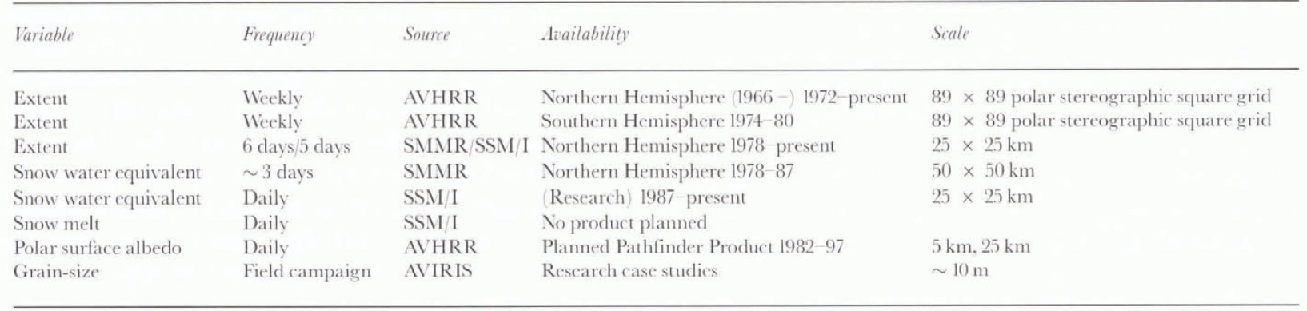
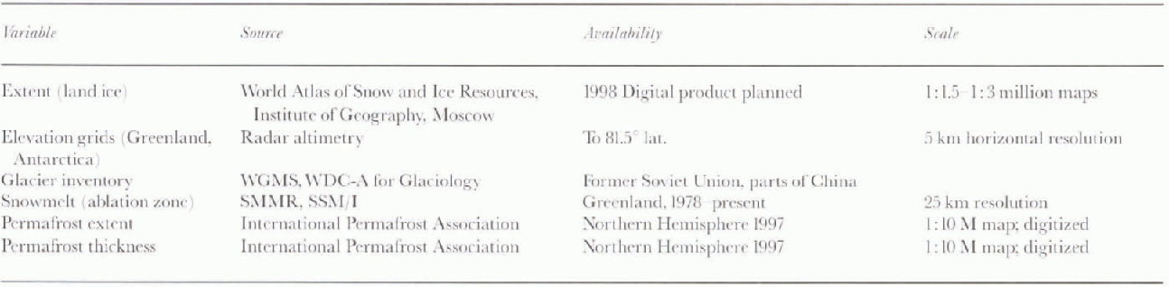
Table 3. Global land-ice variables and their availability
Snow cover
Data on weekly snow-cover extent (see Table 2) are available for the Northern Hemisphere since 1966, based on satellite visible and infrared imagery, but more reliably since 1972 when the Advanced Very High Resolution Radiometer (AVHRR) was first launched. These data do not take account of snow on sea ice or Greenland. There is a limited dataset for South America for 1974–80, the only southern continent with significant snow cover. These NOAA-NESDIS products are, unfortunately, gridded to a polar Stereographic 89 × 89 square cell grid, so that the resolution is variable; also a grid is counted as snow covered if the fractional cover is ≥50%. New products on snow extent that are planned to be available in 1998 on a daily or weekly basis are described in Reference HallHall (1995). A passive-microwave-derived six day (five day) snow-extent product based on the SMMR for 1978–87 (SSM/I for 1987–present with 25 × 25 km gridcells is currently in preparation at NSIDC.
Snow water equivalent (SWE) can be estimated from passive-microwave data and an experimental mid-monthly dataset was generated for 1978–87 by Reference Chang, Foster, Hall, Powell and ChienChang and others (1990). The data have recently been compared with the output of six GCMs (Reference FosterFoster and others, 1996) based on Atmospheric Model Intercomparison Project standard control runs for 1979–88 (Reference GatesGates, 1992). However, Reference Tait and ArmstrongTait and Armstrong (1996) find systematic biases in products obtained with the linear algorithm developed by Reference Chang, Foster, Hall, Powell and ChienChang and others (1990) compared with station measurements. It is clear that spatio-temporal adjustments are necessary in such algorithms to rectify errors caused by topographic effects on SWE values, screening by forest canopies, and the occur-rence of depth hoar or melt on snow-grain surfaces. Nevertheless, the work of Reference GoodisonGoodison (1989) for the Canadian Prairies illustrates the potential of passive-microwave sensors, even for operational products. Reference Walker and GoodisonWalker and Goodison (1993) have also demonstrated that snowmelt signatures are readily detectable with passive-microwave data although this approach has not yet been implemented as a hemispheric analysis product.
For validation purposes, station data are often desirable, but until now these have been mostly climatological averages. Newly available regional datasets include CD-ROMs of daily snow depth at 284 stations in the Former Soviet Union (FSU) from the beginning of observations (NSIDC, 1994) and snow depths at North Pole drifting stations, 1937–38 and 1951–91 (NSIDC, 1996b). Additionally, 10 day snow-course surveys for more than 1300 stations across the FSU for 1966–90 have been received and are currently being quality checked prior to release.
Snow (and ice) albedo is an important model variable that is commonly parameterized. Approaches to this range from simplistic temperature dependencies (linear or step functions), to calculations that take account of snow age, fractional cover, vegetation masking depth, grain-size, solar zenith angle and spectral range. (see Reference BarryBarry, 1996). The AVHRR Polar Pathfinder plans to generate polar surface broadband albedo data products over the next two to three years (Polar Pathfinder Group, 1997). Research on the estimation of snow grain-size via a pixel mixing approach is being carried out using Airborne Visible and Infrared Imaging Spectroradiometer (AVIRIS) data over mountain watersheds (Reference Nolin and DozierNolin and Dozier, 1993) but wide-area implementation of this approach is unlikely in the near future.
Sea ice
Twenty-five years of data on sca-ice extent and concentration for both polar regions are available on a weekly basis since 1972–73 and daily since 1987 (Table 1). These have also been reformatted for use by the European Centre for Medium-Range Forecasta (ECMWF) model re-analysis program (Reference NomuraNomura, 1995). For the northern polar regions, monthly ice extent and concentration data exist since 1953, and these data will be improved retrospectively as 10 day Russian data for the summer period are incorporated. Since 1900 there are also monthly extent data, mainly for the North Atlantic sector, that are less reliable and more spatially heterogeneous.
Currently there are only limited climatological ice-thickness maps for the Arctic Ocean (Reference Bourke and McLarenBourke and McLaren, 1992), and no digilal archive. There are also extensive published thickness-frequency data for the Arctic and more limited publications for the Antarctic. An atlas of morphological characteristics in the Arctic Ocean exists in digital form (Reference RomanovRomanov, 1993), although information on snow cover on the ice is limited, and those are only point or limited-area data on melt-pond coverage. Melt onset dates can be estimated from passive-microwave signatures, and work is in progress in provide a dataset for 1978–present. There are also limited data on lead coverage (Reference Lindsay and RothrockLindsay and Rothrock, 1995).
Ice surface albedo has been mapped in the Arctic for 10 summer seasons using visible satellite images classified subjectively, as well through analyses of radiance data. However, averages for individual months are currently only within about ±0.10 (Reference Schweiger, Serreze and KeySchweiger and others. 1993). Techniques are available to estimate ice surface temperature from infrared radiance data and products for broadband surface albedo, ice surface temperature and a cloud mask will be generated by the AVHRR Polar Pathfinder for 1982–97 (Polar Pathfinder Group, 1997). In addition, the TIROS Operational Vertical Sounder (TOVS) Polar Pathfinder will provide daily and monthly gridded products of surface skin-temperature and boundary-layer parameters for 1979–97. The EOS Polar Exchange at the Sea Surface (POLES) project also plans to produce products of sea-ice statistics from MODIS and Radarsat data (Reference RothrockRothrock and others, 1995).
Land ice
Remarkably, the state of information on basic land-ice parameters is the least satisfactory (Table 3) . There is currently no digital archive of land-ice extent and elevation. Even inventory data on glaciers are unavailable for several countries with large ice areas, including Canada (Reference BarryBarry, 1995) and the Himalayan nations, although partial national archives exist. In other areas, such as China and South America, satellite mapping is in progress. Data on surface elevation for the Greenland and Antartic ice sheets poleward to 81.5 latitude are available from satellite radar altimetry collected by ERS-1 and ERS-2. In 1998 the Radarsat Antarctic Mapping Program will collect data for the first complete high-resolution digital map of all of Antarctica (Polar Pathfinder Group, 1997).
Future plans include the precision mapping of Greenland and Antarctica by the EOS Geoscience Laser Altimeter System (GLAS) in about 2002 and the mapping of selected target glaciers via the Advanced Spaceborne Thermal Emission and Reflection Radiometer (ASTER), in conjunction with a proposed Global Land Ice Monitoring with Satellites (GLIMS) (Reference Kargel and KiefferKargel and Kieffer, 1995).
Data on general ground ice and frozen ground conditions are currently not available in digital form, although a digital version of a Northern Hemisphere map of perennially frozen ground (Reference Brown, Ferrians, Heginbottom and MelnikovBrown and others, in press) is in preparation. Under the auspices of the International Permafrost Association, a project to develop a Global Geo-cryological Database is currently in progress and a CD-ROM is planned for release in mid 1998 (Reference Barry, Heginbottom and BrownBarry and others, 1995).
Concluding Remarks
Data products characterizing many large-scale properties of the cryopshere, and suitable for the validation of GCM control experiments, are now available. Notable gaps exist for land-ice extent and frozen ground characteristics, although such products are planned, or are in preparation. In the case of the seasonally varying elements (snow cover and sea ice), time series of their extent are available individually, or combined. The weekly 25 × 25 km combined snow-cover and sea-ice dataset (17 years) for the Northern Hemisphere should be especially valuable for climate model validation. However, for snow depth (water equivalent) and ice thickness, even reliable climatologies remain to be developed. Intercomparisons of NOAA visible-based and NASA passive-microwave derived snow extent by Reference RobinsonRobinson (1997) and Armstrong (personal communication from R. L. Amstrong, 1996) show significant discrepancies. Whether these exhibit systematic spatial and temporal biases remains to be determined. Nevertheless, further improvement in this situation can be expected over the next few years as blended satellite and ground data on SWE are produced and newly released in situ ice-thickness measurements become available for the Arctic Ocean. It is in the area of derived parameters (such as albedo and snow grain-size) that much additional work remains to be done. There is also a significant need for readily accessible test data for process model validation in all areas of cryospheric research. An illustration of what is currenlly available is provided by the holdings of the National Science Foundation's Arctic System Science (ARCSS) Data Coordination Center at the National Snow and Ice Data Center (Reference McGinnis and CrossMcGinnis and Cross, 1997) and accessible via the World Wide Web.
Acknowledgements
Supported in part by University of Washington (POLES) subcontract to the University of Colorado. Thanks are due to L. Ryder for word processing.


