


Introduction
Evidence from general circulation models (GCMs) suggests that anthropogenically induced global warming will be greatly enhanced in the polar regions. Consequently, these models are being used increasingly for coupled climatic simulations involving ice sheets. They were, however, designed mainly to simulate the climates of low- and middle-latitude regions. Their performance over the ice sheets has, however, produced some promising results. In particular, precipitation over Antarctica, simulated with the UK Universities Global Atmospheric Modelling Programme General Circulation Model (UGAMP GCM, hereafter referred to as the UGCM) is, generally, in good agreement with the available observations for the central plateau region of the ice sheet. Systematic errors, however, seem to be related to an inaccurate representation of the topography, especially around the margins. Good model resolution is particularly important for regional climate studies, and even more in regions strongly influenced by topography, as is the case for Antarctica. However, the computational cost of running a GCM limits most applications to a T42 version of the model. For the internal regions of Antarctica, the spectral envelope topography used with a T42 resolution is, in general, adequate. Around the edge of the ice sheet, however, where surface slopes are largest, this resolution does not correctly represent the variation in surface elevation. Most of the marginal points in ihc UGCM are at relatively high altitudes (above 1000 m). Furthermore, none of the Antarctic ice shelves are considered to be land and the Antarctic continent covers only 12.2 × 10⁶ km2, considerably less than the currently estimated area of 13.9 × 10⁶ km2 (Reference DrewryDrewry 1983). In addition, it appears that the original database used to set the model surface elevation is in error by > 1000 m in some central regions (Reference Genthon and BraunGenthon and Braun, 1995).
A high-resolution, high-accuracy digital elevation model (DEM) of the Antarctic ice sheet is now available (Reference Bamber and HuybrechtsBamber and Huybrechts, 1996). The DFM was derived, primarily, from radar altimeter data from the satellite ERS-1. South of 81.5°, the latitudinal limit of the satellite, and in areas of high relief, such as the Transantarctic Mountains, the altimetry has been supplemented by data from other sources. Where there is good altimetric coverage, the vertical accuracy is better than 1.5 m, and the real spatial resolution of the DEM is about 5 km. South of 81.5° the vertical errors are to the order of 100 m, and the resolution is about a factor of 10 worse. However, this still represents a substantial improvement on what was previously being used, and is in an area of small surface slopes and hence little topography variation. To assess the influence of the topography on the simulated climate of Antarctica, several experiments were carried out, progressively improving the geographic representation of the ice sheet in the UGCM. We studied the influence on the modelled Antarctic climate by (i) including the ice shelves in the continental domain and representing the ice sheet by its real area, (ii) correcting the altitude errors existing in central Antarctica, and (iii) using a mean topography instead of an envelope topography (see the section on the model). The effect of these various improvements on the pattern of accumulation, surface air temperature and radiation balance was examined in detail for both summer and winter.
Design of the Experiments
To study the effect of each type of change, two sets of perpetual January and July experiments were carried out (suffixed, in the text and diagrams by 01 and 07 respectively). All January experiments were begun from a standard start dataset based on climatology, whilst all July experiments were begun from the results of a previous run. In summer (January), the solar radiance contributes to the energy budget. The atmospheric circulation and, in particular, the katabatic winds, are relatively weak. In winter (July), however, there is no solar radiation, the surface energy balance is dominated by infrared fluxes and the surface winds are at their maximum. Implementation of the new mask was accompanied by modification of the background albedo, soil moisture (a parameter required for all land surfaces to calculate evaporation), snow depth and roughness length of the affected cells. The values were set equal to the neighbouring continental values. Due to their rapid adaptation to the new topographic conditions, the initial surface temperature and pressure were not corrected. Table 1 lists the various experiments that were carried out and are described in the following sections. Differences between the new and old land masks are indicated in Figure 1.
Table 1. The different experiements carried out with the UGCM
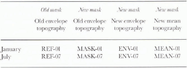
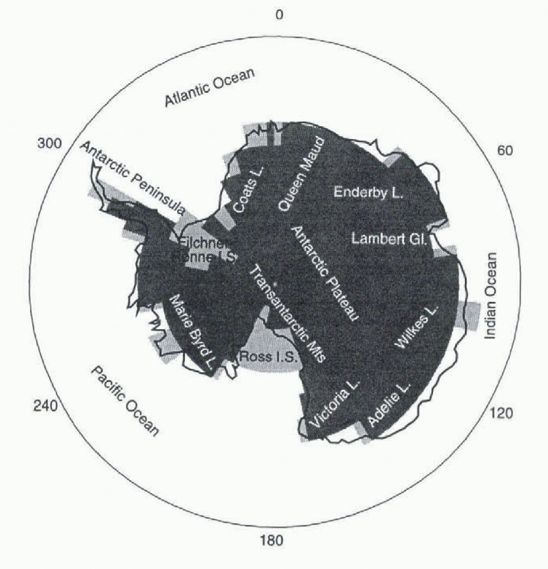
Fig. 1 The old land-sea mask (dark grey) and gridhoxes added to the old mask to form the new land-sea mask (light grey). Place names referred to in the text are also included.
The Model
The UGCM is based on the forecast model of the European Centre for Medium-Range Weather Forecasts (ECMWF). The version used here is identical to that described in Reference MarsiatMarsiat (1996). It is a spectral model using a sigma-pressure hybrid vertical coordinate and using a triangular truncation at a total wave number of 42. The physical parameterisations are evaluated on a longitude-latitude (Gaussian) grid of 128 × 64 points, where the mesh size is approximately 2.8°. The model has 19 levels in the vertical, 5 of which are within the boundary layer (150 h Pa of the surface). The original topography of the UGAMP GCM is a T42 truncated version of the T106 envelope derived directly from the US Navy topography. The US Navy dataset was provided on a 10 arc minute regular grid. The envelope topography is calculated from the following expression:
where g = 9.80665 is the acceleration of the Earth’s gravity, Hm is the mean height on the UGCM grid retrieved from the US Navy dataset, α is the proportion of standard deviation to be added to the mean height over land points (α = 1 for a full envelope topography) and σ is the standard deviation of mean height defined for the same grid as Hm. Practically, the 10 arc minute US Navy topography was interpolated to the T106 corresponding grid, smoothed using a Gaussian filter with a radius of 50 km, and the spectral fit was applied to the filtered orography. A further truncation of the T106 envelope was then performed to obtain the T42 envelope orography. The new topographies used in this paper have been obtained in a similar way.
First, the DEM was interpolated onto a 0.25° spherical grid. Then, envelope topography (Equation (1) with α = 1) and mean topography (Equadon (1) with α = 0) were computed on the T42 corresponding grid. Differences between the new and the old topography (δenv) and the new mean and the old topography (δmean) were then computed on the T42 grid. A spectral fit was then applied to the delta fields. Spectrally truncated δ fields were added to the old topography to obtain the new (spectrally fitted) envelope topography and the new (spectrally fitted) mean topography. It should be noted that the DEM only covered the Antarctic continent, and that the topography of the rest of the Earth has not been changed.
Modifying the Land-Sea Mask
Due to the spectral fitting, most of the sea points have nonzero altitude. The land�sea pattern must, therefore, be independent of the orographic height. The original land-sea mask assumed that the gridbox contained land if the land proportion in the gridbox was ≥ 0.5. The ice shelves were treated as sea ice. In the experiments described here, the Ross and Filchner-Ronne Ice Shelves were defined as land. In addition, to obtain the correct continental area for the model, a gridbox was defined as land when the land proportion was ≥ 0.46. This gave an area of 13.972 × 10⁶ km2 for the Antarctic continent in the UGCM model.
The UGCM is an atmospheric model using fixed climatological values for the sea and sea-ice surface temperature. Modifying the mask changes the number and position of gridpoints where the surface temperatures are computed from the surface energy balance instead of being taken from the climatology. If the integration is started with background albedo values equal to the former sea-ice albedo value (0.55), most of these gridpoints rapidly reach an albedo of 0.8 due to the presence of snow. Changing the mask, therefore, has an immediate and local effect of reducing the amount of solar energy absorbed by the surface and increasing the amount being reflected. In winter, however, the albedo plays no role and differences between the new run (MASK 07) and reference run (REF07) are driven by the differences of computed infrared and turbulent fluxes of gridpoints, the surface temperatures of which are progressively diverging from the Climatological value.
Although mask modification affects only the ice shelves and some marginal areas (Fig. 1), the first experiment showed that it strongly influences the air and surface temperature in the interior of the continent through modification of the air circulation (Fig. 2a, b). In summer, the decrease of temperature observed over the Ross Ice Shelf is associated with a strong increase in the wind speed (+3.5 m s−1) along the Transantarctic Mountains and to the deflection of the winds towards the centre of the Ice Shelf. The loss of energy through turbulent fluxes is strongly increased (+100 W m−2) reducing the temperature by > 4.4°C Over the mountainous area on the eastern side of the Ross Ice Shelf. Inversely, on the western side, winds originally oriented towards the centre of the shelf are weaker and flowing parallel to the continental coastline. A decrease of the loss of turbulent energy (−30 W m−2) is observed.
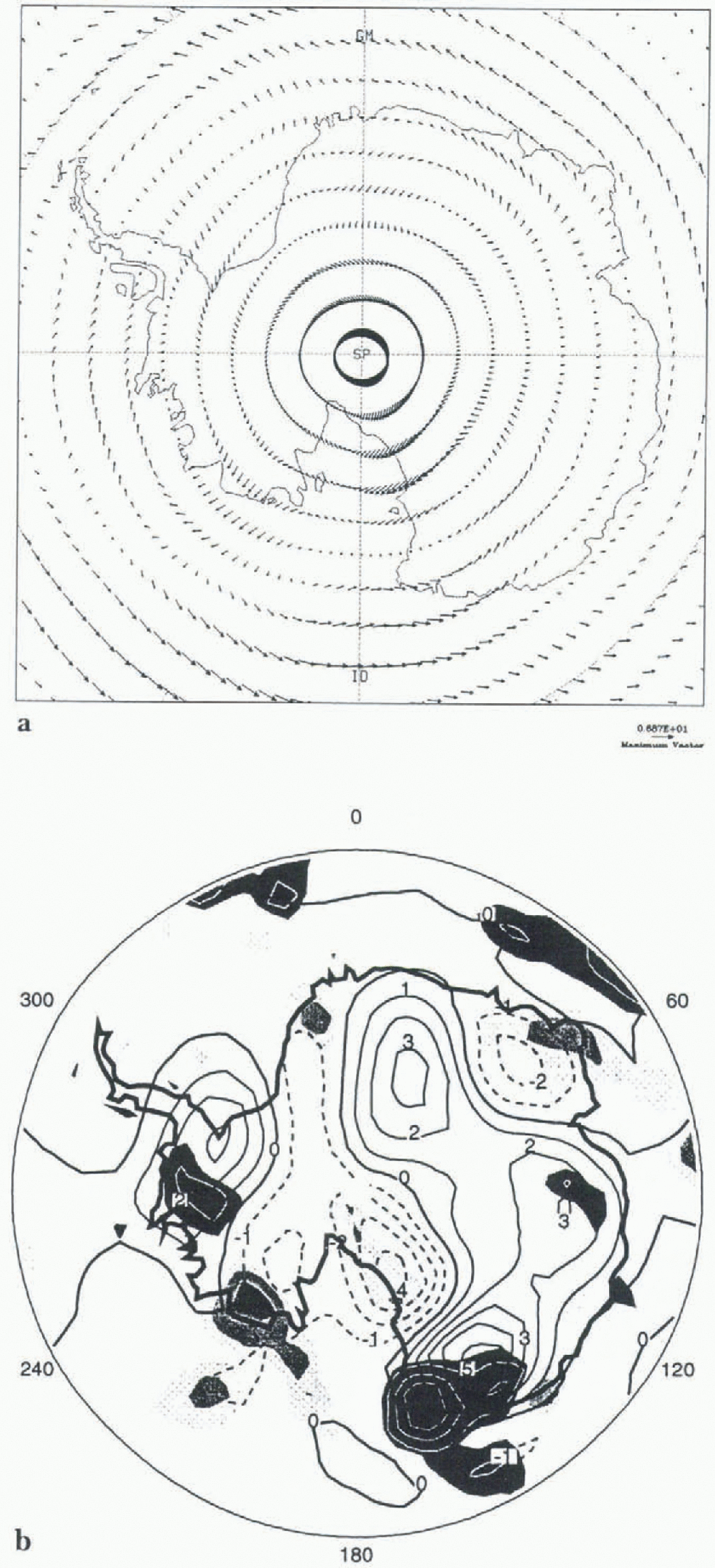
Fig. 2 The summer wind-vector difference between MASK-01 and REF-01. (b) Air temperature differences at the lowest model level between the runs MASK-Ol and REF-01. The solid lines are positive differences and dashed lines are negative differences. The contour interval is 1°C. Precipitation differences between MASK-Ol and REF-01 are plotted as shaded contours in units of mm d−1 w.e. with contours plotted in white. The contour interval is 1 mm d−1.
Seaward from the Ross Ice Shelf, winds that were originally westerly have become easterly (Fig. 2a), increasing the amount of warm and humid air reaching Victoria Land and increasing the temperatures (+5.8° C) and snowfall rate (+3 mm d−1) in this area (Fig. 2b). The opposite effect is observed along Marie Byrd Land, with a decrease of snow precipitation. Over the Filchner-Ronne Ice Shelf, the speed of the winds flowing down the ice sheet on to the Shelf is reduced by 2ms−1 leading to an increase in temperature. Inversely, an increase in the surface wind speed Over Ender-by Land is associated with a decrease in temperature. Temperatures increase everywhere over the plateau, but particularly inland of Dronning Maud Land (+3.3°C) and the Antarctic Peninsula (+3.3°C, Fig. 2b). Around the Continent, the eastward component of the circulation is in general less strong (Fig. 2a).
The winter simulation shows a completely different pattern of temperature variation (Fig. 3b). The sector between 90°W and 270°W, together with the Filchner-Ronne and Amery Ice Shelves experience a cooling reaching −10°C inland of Wilkes Land, and >−13°C in Marie Byrd Land. On the western part of Wilkes Land, a strong increase in the speed and the seaward component of the wind (Fig. 3a) is observed, reversing the direction of the flow in some places. The biggest modification of air circulation, however, appears off West Antarctica, associated with a decrease of pressure of > 30 hPa over the Pacific Ocean. Strong winds originally directed from the sea to the continent off Marie Byrd Land and the Ross Ice Shelf have been replaced by weak westerly winds Over the sea and winds coming from inside the continent along the coast, leading to a strong temperature and snow precipitation (Fig. 3b) decrease over most of the West Antarctic ice sheet (WAIS). Inversely, inflow of moist and warm oceanic air masses is responsible for an increase in temperature and precipitation along Coats Land (4°C). Unlike the summer pattern, the winds around the continent have a much stronger eastward component.
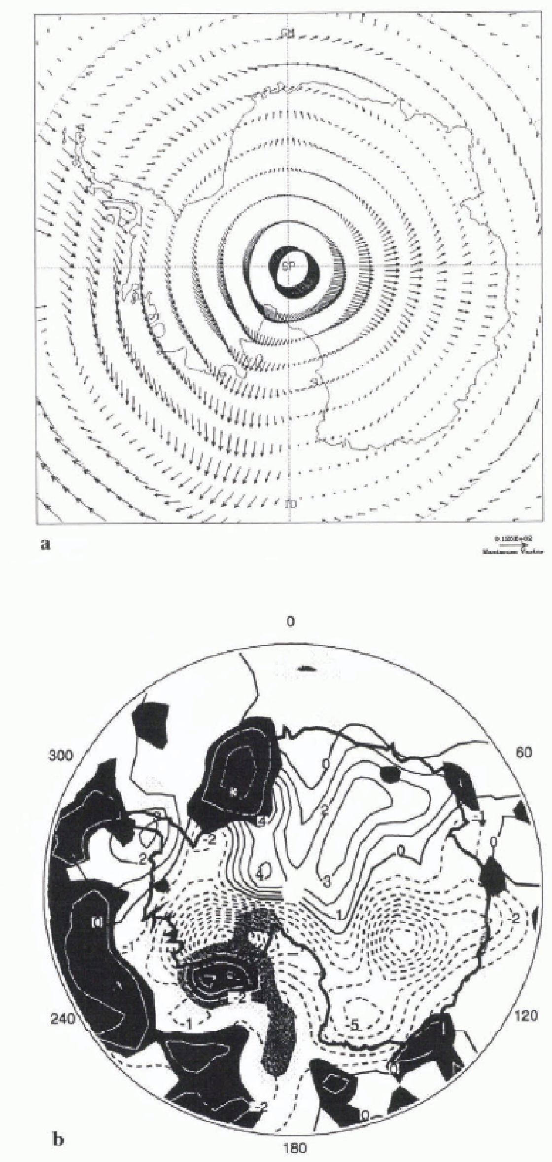
Fig. 3. (a) The winter wind-vector difference between MASK-07 and REF-07. (b) As for Figure 2b but for the winter runs MASK-07 and REF-07.
In general, surface temperature changes appear to reflect the changes in wind pattern. However, surface temperature differences over the ice shelves do not reflect the physical processes because the standard run temperatures are taken from climatology. There are, however, no systematic trends in the computed surface temperature being cooler or warmer than the climatology. The new mask was also responsible, in summer, for a global increase in pressure over the ice sheet, with maximum increases over the ice shelves (+8 hPa Ross Ice Shelf and +5 hPa Filchner-Ronne Ice Shelf) and a global decrease in winter of a few hPa.
Using the New Envelope Topography
The mean topography (described in the next section) provides a more realistic representation of the true surface, especially in the margins, where the envelope topography tends to overestimate the height. However, the majority of GCMs use an envelope topography and, for this reason, the main results from using the new envelope topography are presented here. For the sake of brevity only a summary of the results are presented.
The old US Navy topography was found to be in error over East Antarctica by > 500 m in some areas and as much as 1000 m in the sector of Dronning Maud Land (Reference Genthon and BraunGenthon and Braun, 1995). Even if the spectrally truncated envelope orography cannot keep all the details of the original topography it is derived from, using a more accurate topographs database to define the model topography will have an influence on the model’s results. Figure 4 shows the difference between the new and old envelope topography. Except for the sector of Dronning Maud Land where the topography is reduced by > 600 m and the region around the Lambert Glacier, the new envelope topography is higher, particularly along the margin. In the simulations discussed here (ENV-Ol and ENV-07), we implemented the new mask together with the new topography, and the results were then compared to the MASK-01 and MASK-07 experiments discussed in the previous section. Similar analyses for the new envelope topography were carried out as for the change of mask in the previous section. Elevation changes directly alter the air and surface temperature through the vertical lapse rate. Large changes, however, also modify the circulation locally and globally, enhancing or reducing the lapse-rate effect.
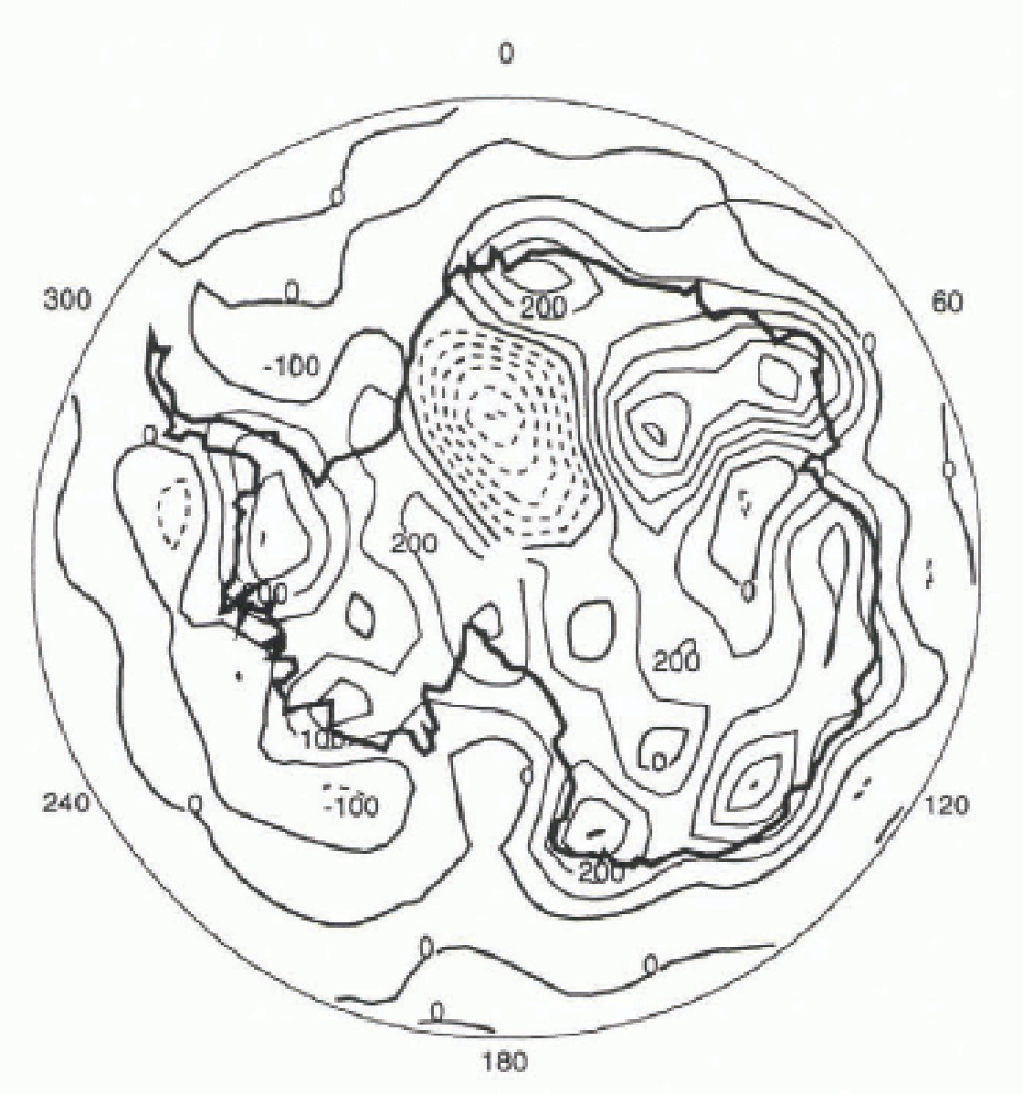
Fig. 4 Difference (in m) between the new and the old envelope topography. The contour interval is 100 m and negative differences are plotted with dashed lines.
In summer, the air temperature-difference pattern over East Antarctica reflects the altitude changes quite well. A temperature decrease of > 5°C is observed inland of Ender-by Land, reflecting the increase of altitude up to 500 m and a concurrent increase of the wind speed. A smaller increase of temperature (2–3°C) seems to be associated with the lowering of altitude inland of Coats Land (by > 600 m), but is reduced by the effect of the increased wind component directed downslope. The eastern WAIS shows a small increase of temperature where the topography has increased by 400 m, which is an opposite effect to the direct lapse-rate cooling. It is due to an increase in the air masses coming from the sea, and is associated with an increase of snow accumulation along the coast. Over most of the WAIS, however, there is a strong decrease in temperature (up to −4.7°C), where the topography has changed by no more than 100 m. This remains unexplained.
The lapse-rate effect is reduced in winter where there is an intense warming (>7°C) over the WAIS associated with the strong decrease in wind speed flowing down to the sea and to the increase in the circulation coming from the sea. The latter is associated with an increase of snow accumulation along the coast. Inversely, the warming effect of lowering the elevation in Dronning Maud Land is reversed by the intensification of the winds directed to the sea, which leads to a decrease in accumulation rates (−2.4 mm d−1) along the Coats Land coast. On the coast of East Antarctica, temperature changes reflect more closely the altitude changes, with a global cooling, except in areas close to the Lambert Glacier.
Using the Mean Topography
Figure 5 shows the differences between the new mean topography and the original one used in the OCM. Fxcepi for positiv e differences of > 600 m in Enderby Land and small increases over the major WAIS ice shelves, the mean topography is lower than the old topography. The biggest difference observed is around Coats Land and Dronning Maud Land, where the elevation is lower by as much as 750 m.
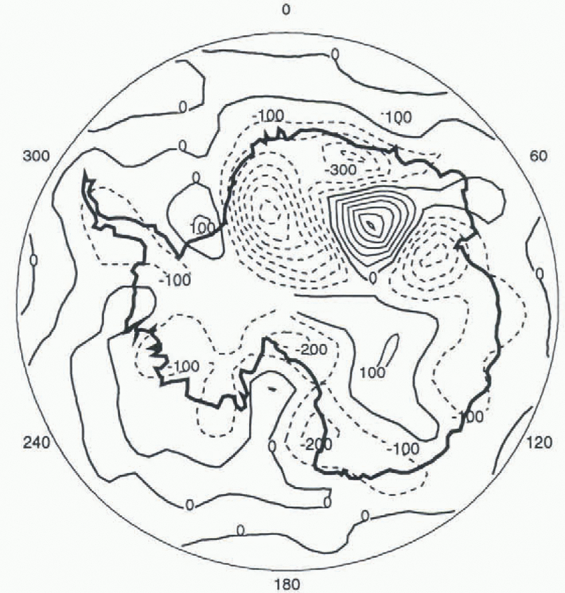
Fig. 5 Difference (in m) between the new and the old envelope topography. The contour interval is 100 m and negative differences are plotted with dashed lines.
As with the envelope topography, the new mean topography has been implemented together with the new mask described earlier. As in the other experiments, modification of air circulation over the Pacific Ocean (Fig. 6a) influences the temperature and the precipitation pattern (Fig. 6b) over the WAIS. For example, an increase in the cyclonic activity in the Ross Sea has the effect of bringing warm and humid air to the coast (Fig. 6a), increasing the temperature on the ice shelf and accumulation on its western flank and decreasing accumulation along Victoria Land (Fig. 6b). Air temperatures for the January run (MEAN-01) are generally higher than in the run with the old topography (REF-01) (Fig. 6b). In East Antarctica, the modification of air circulation close to the surface of the ice sheets is similar to the modification introduced by the new envelope topography.
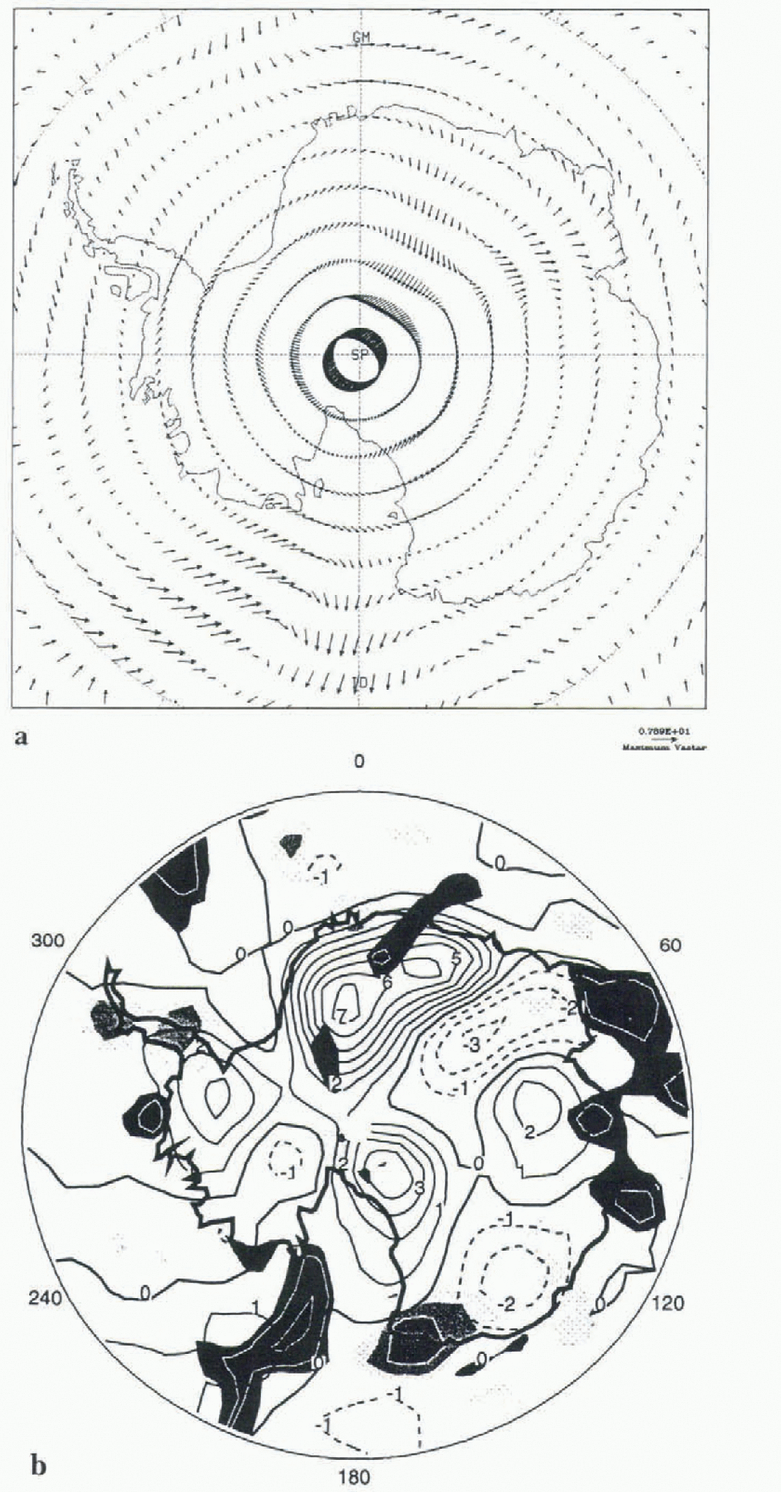
Fig. 6. (a) The summer wind-vector difference between MEAN-01 and MASK-01, (b) as for Figure 2b but for the runs MEAN-01 and MASK-01
The change in circulation pattern over the Pacific Ocean is also observed in winter (Fig. 7a), but in this case it is to the east of the Antarctic Peninsula and results in a general increase in accumulation along the coast of West Antarctica (Fig. 7b). An additional decrease of wind speed over the continent in winter is associated with a general warming. This is enhanced in winter along a belt surrounding the centre of East Antarctica (Fig. 7b). The effect of the change in elevation on climate is, consequently, enhanced by a decrease in the wind speed and/or the downward slope component. However, a cooling of > 6°C is observed in the middle of the Antarctic plateau. Both ice shelves experience a cooling (−7°C over the Filchner-Ronne Ice Shelf) and a decrease of accumulation rate due to the increase of the katabatic winds flowing down to the sea (Figs 7a, b).
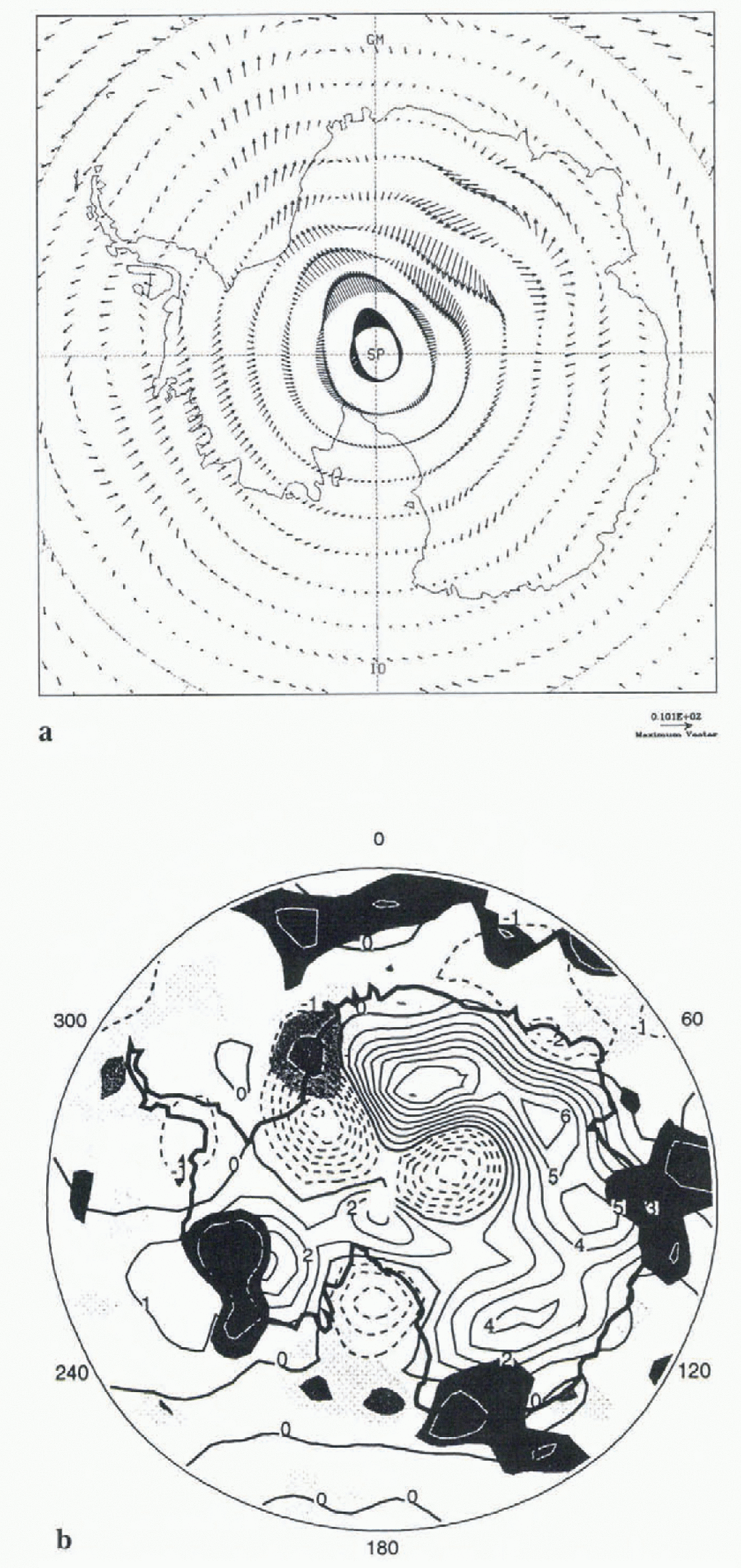
Fig. 7. (a) The winter wind-vector difference between MEAN-07 and MASK-07. (b) as for Figure 2b but for the runs MEAN-07 and MASK-07.
Conclusions
Important limitations exist in the representation of the topography of Antarctica in the UGCM. These limitations have been examined through a number of experiments using an improved land mask and topography dataset. Both of these improvements were found to have a substantial influence on the simulated climate over Antarctica. The new mask produced winter temperature changes of up to 13°C, and precipitation changes of up to 100% of the annual mean. The new topography introduced changes of a similar magnitude. The results of these experiments, clearly indicate the importance of defining the topography in the most realistic and representative way given the constraints placed by the resolution of the GCM. The behaviour of the model is, however, complex, highly non-linear and analysis of a full year’s seasonal experiments is necessary to assess whether a more accurate topography will produce more realistic results (compared to the measured climatology). However, a preliminary comparison between the modelled mean annual temperature and the climatology indicates an improvement in the representation of this field, especially around the margins.
In most of the sensitivity experiments, wind-pattern modifications along the slopes of the ice sheet were linked io the strongest changes in temperature and accumulation. The magnitude of these katabatic winds were dependent upon the local slope as well as the temperature differences between the plateau and the ocean. Further improvement in the model could be expected, therefore, from using filters to reduce topographic errors along the margins, which are an inevitable result of the spectral fitting procedure.
Acknowledgements
I. Marsiat has benefitted from an EC Human Capital and Mobility fellowship (EV5V-CT94-5221). J. L. Bamber was funded by a NERC Earth Observation lectureship. We would like to thank P. Valdes and M. Blackburn for helpful discussions.


