


Introduction
Owing to their sensitivity to climate changes, Alpine glaciers are considered among the most important palaeoclimatic indicators. The dynamic response of glaciers is controlled by the energy and mass budgets. The latter, in temperate regions, depends on the temperature of the ablation season and on snowfall. The data obtainable from glacial deposits allow continuous or discontinuous temporal sequences of glacial changes to be reconstructed, so that both direction and intensity of climate changes may be deduced.
Many investigations have been carried out on the Alpine chain, both in the past and present, in order to better understand the glaciers’ patterns of response and collect more information on climate change (Reference AhlmannAhlmann, 1953; Reference HoinkesHoinkes, 1968; Reference KuhnKuhn, 1981; Reference Haeberli, Muller, Alean, Bosch and OerlemansHaeberli and others, 1989; Reference Oerlemans and OerlemansOerlemans, 1989; Reference MaischMaisch, 1992; Haeberli, 1995).
In this research, the period considered for assessing area and volume changes is from the maximum extent of the Little Ice Age (LIA) up to the present. In the Valle d’Aosta (western Alps, Italy), the LIA peaked in 1820, according to Reference VanniVanni (1939) and Reference Orombelli and PorterOrombelli and Porter (1982). The presentday reference is taken as 1981.
The LIA corresponds to the latest phase of Neoglacial expansion attained by mountain glaciers (Reference Porter and DentonPorter and Denton, 1967): it was coeval in most parts of the Earth in response to a climate change that, although limited, had a global effect (Reference PorterPorter, 1986; Röthlisberger, 1986). For many glaciers in the Alps and Northern Hemisphere, this advance was the greatest of the Holocene (Reference Porter, Wigley, Ingram and FarmerPorter, 1981, Reference Porter1986; Reference Nesje, Kvamme, Rye and vlieNesje and others, 1991). Also, in the Southern Hemisphere, the LIA advance is indicated as the “major episode of glacier expansion” (Reference PorterPorter, 1975) during the Neoglacial. The beginning of the LIA, which was preceded by the Medieval Warm Period, may be placed between the 13th and the 14th centuries AD, whereas its climax took place between the mid-16th and the mid-19th centuries (Reference Grove and HaeberliGrove, 1988).
The aim of this research was to assess the area and volume of glacier retreat at the head of Valpelline and Valtournenche (Valle d’Aosta) by interpreting deglaciated landforms and with the help of a geographical information system (GIS).
Reconstruction of LIA Ice Extent
Reconstruction of the maximum expansion attained by glaciers during the LIA was carried out using field survey, air photo interpretation and analysis of historical records. The mapping data thus collected were computerized and analyzed with a GIS. Different programs have been used. Both the present and the LIA extent and topography of every glacier has been digitized. Each map with glaciers has been georeferenced. In this way, data on glaciated areas at the maximum phase of the LIA expansion and at present were obtained. Furthermore, by comparing the present topography with the LIA reconstruction, the difference in ice volume between the LIA glaciers and the present situation was assessed. However, it was only possible to obtain data on the volume difference since no information was available on the depth of the bedrock and therefore on the ice thickness.
The Valpelline Glaciers
The glaciers located at the head of Valpelline from west to east are the following: Mont Braulè, Tza de Tzan, Grandes Murailles, Petites Murailles, Dames, Bellatzà and Solatsèt (Fig. 1). Of all these glaciers, those which have aroused the greatest interest among researchers are the Tza de Tzan and Grandes Murailles, for which the most abundant documentation also exists. The Tza de Tzan and Grandes Murailles glaciers occupy the great terminal cirque of Valpelline. At present, both their fronts and firn fields are separate. The data available from literature show that, in the Middle Ages, the extent of these two glaciers was more limited: many mountain passes, no longer open today, were used in the Middle Ages (Röthlisberger, 1974; Reference VanniVanni, 1939); also the altitude limit for farming practices and human settlements was higher than today (Reference VanniVanni, 1939; Reference RevelliRevelli, 1917). These conditions must have lasted until the mid-17th century since, from this period onwards, the valley was affected by a decline in road practicability and in the number of inhabitants. A phase of climate deterioration began, causing the termini of Tza de Tzan and Grandes Murailles glaciers to converge and extend as far as the rock step overhanging Alpe Gorgé (2156 m) (Fig. 1).
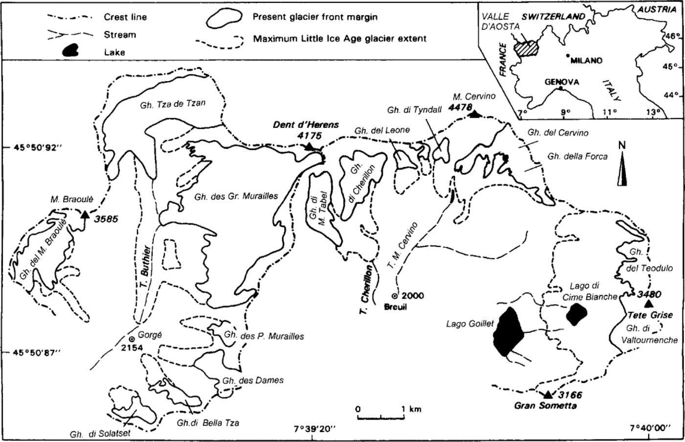
Fig. 1. Locations of glaciers studied in upper Valpelline and Valtournenche.
Today, the valley is free from ice and has a characteristic and imposing U-shaped profile (Fig. 2). On the valley side there is a trimline. The lower part of the slope is covered by heterogeneous glacial deposits and the upper part by continuous vegetation. This line indicates the vertical extent of the Tza de Tzan glacier that was nearly 200 m thick during the LIA maximum. The valley floor is covered by a continuous till deposit, showing different degrees of colonization by vegetation.

Fig. 2. U-profile of upper Valpelline after retreat of Tza de Tzan glacier. Trimline is clearly visible on right; line between lower slope covered with heterogenous glacial deposits and upper part covered with continuous vegetation (photo by C. Vanuzzo).
The separation of the Grandes Murailles and Tza de Tzan glaciers was reported by Reference FrisaFrisa (1956), and by 1965 they were described as separate entities (Reference VanniVanni, 1966). Figures 3 and 4 show the considerable recession at the confluence zone of the two glaciers from the end of the last century to 1994. At present, the right-hand lateral moraine of the Grandes Murailles glacier is the only remnant of the ancient ice which once covered this valley. Figure 5 shows the dynamic aspects of the two glaciers’ fronts based on data collected by Italian researchers early in the 20th century: both glaciers show a progressive retreat and record the moderate positive fluctuation of the 1970s and 1980s, which started respectively in 1968 for the Grandes Murailles and in 1971 for the Tza de Tzan glaciers.

Fig. 3. Confluence of the Grandes Murailles and Tza de Tzan glaciers between the end of the 19th and beginning of the 20th centuries (photo by Ferrai, property of “Fondazione Sella”, Biella Italy). The Tza de Tzan flows from left to right.

Fig. 4. Approximately the same view as Figure 3 in summer 1994 (photo by C. Vanuzzo). The right moraine of the Grandes Murailles glacier, which flowed into the Tza de Tzan glacier until the middle of this century to form the Ghiacciaio di Tza de Tzan Inferiore, is visible. This area is now ice-free. The snout of Tza de Tzan glacier is more withdrawn (left of the photo).
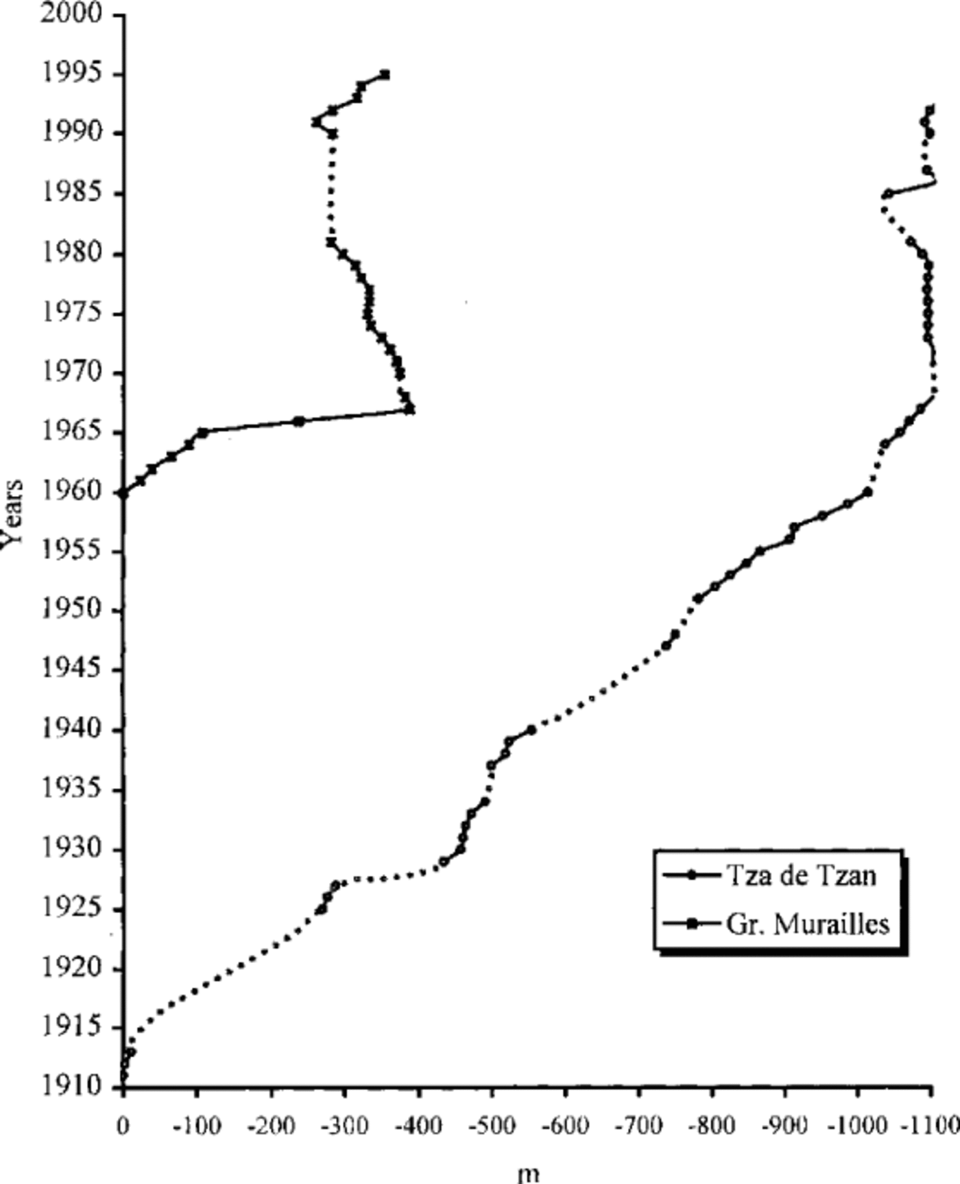
Fig. 5. Recession of the Tza de Tzan and Grandes Murailles glaciers. The dotted line represents missing data.
The Valtournenche Glaciers
From west to east, the Valtournenche glaciers are as follows: Mont Tabel, Cherillon, Leone (Inferiore and Superiore), Tyndall, Cervino (Matterhorn), Forca, Teódulo and Valtournenche (Fig. 1). The Valtournenche and Teódulo glaciers are broad, with a low inclination at the foot of the crest stretching from Tête du Breuil (3467 m) as far as the boundary with the Ventina glacier. The historical data available on the Valtournenche glacier show that in Roman and Medieval times the ice cover was less than today (Reference LescaLesca and others, 1955), as was the case with the Tza de Tzan glacier. A new phase of glacial advance has been described starting in the mid-18th century; all the 19th century maps particularly depict the glaciers of this area as very large (Reference LescaLesca and others, 1955).
Evidence of the LIA advance phase is the presence of chaotically deposited till, seldom arranged in morainic ridges, in the proglacial area; clasts are heterogeneous and range from a few centimetres to 1–2 m, with scarce or sometimes no lichen cover. The boundary between the till and the Alpine tundra, which was unaffected by the glacier during the Holocene, is quite visible. A fluted-moraine forefield can be seen on aerial photographs which do not show the patterned ground that can be seen in the field, such as sorted stone circles, 1–2 m in diameter. In the proglacial area, numerous small glacial lakes are found, formed after the gradual glacier retreat; the largest is Lago di Cime Bianche (2804 m a.s.l.) created in 1934. Data on fluctuations of Valtournenche glacier, from the early 1900s onwards, are summarized in Figure 6.
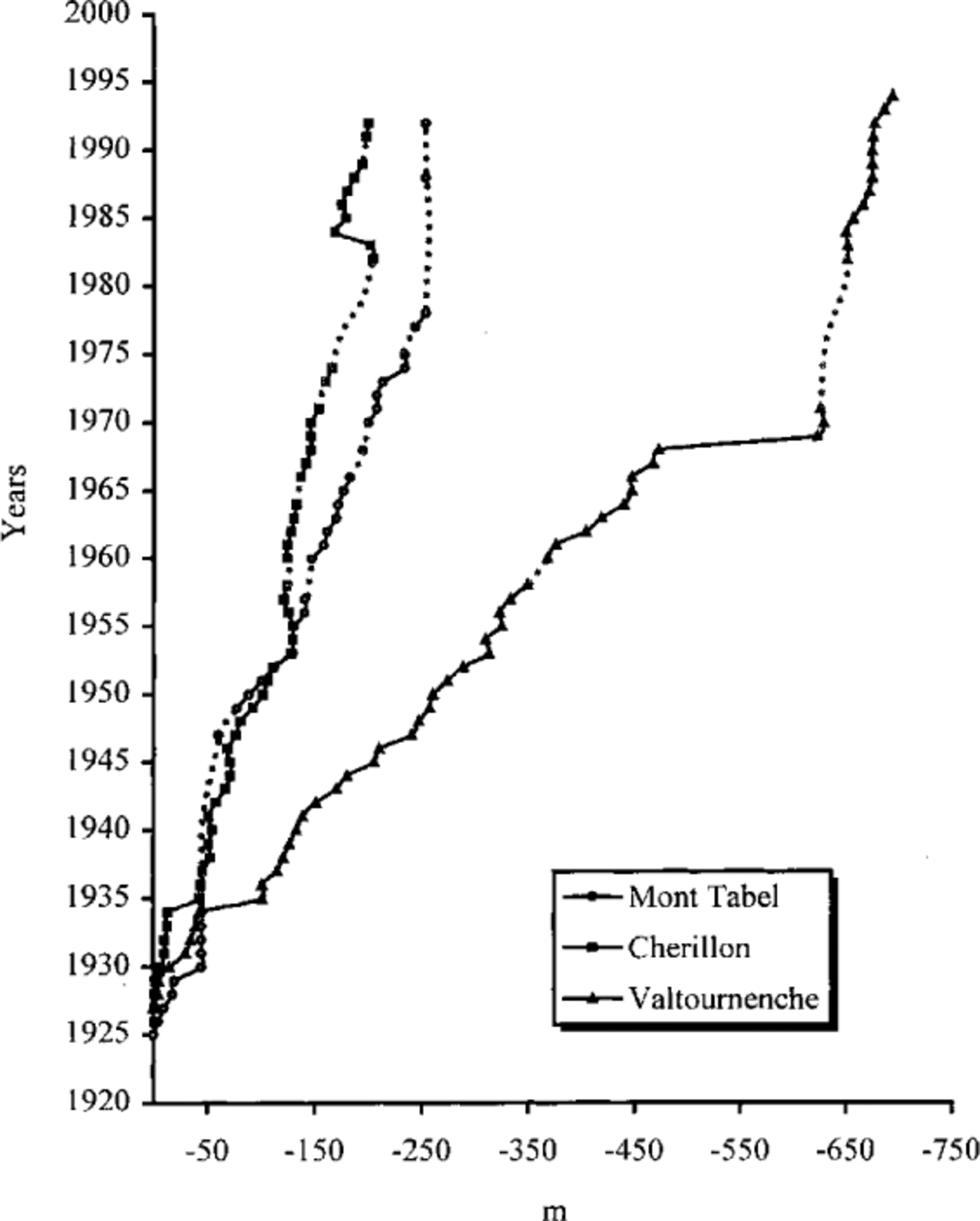
Fig. 6. Recession of Valtournenche, Mont Tabel and Cherillon glaciers. The dotted line represents mising data.
The Mont Tabel and Cherillon glaciers are found on the western slope of Valtournenche. Their fronts, united during the maximum LIA expansion, deposited an impressive semicircular moraine (Fig. 7). The fluctuations of these two glaciers have been reconstructed and are also shown in Figure 6.

Fig. 7. The semicircular moraine of Cherillon glacier. The glacier flows from right to left (photo by C. Vanuzzo).
Changes in the Area of the Valpelline and Valtournenche Glaciers
The Valpelline glaciers have lost 29.21 % of their area since the LIA maximum, from 20.13 km2 during the LIA, to 14.25 km2 today, a reduction of 5.88 km2 (Table 1). Using data from Reference Vanni, Origlia and de GeminiVanni and others (1953), it was possible to reconstruct some of the recessional stages of the Mont Braulè, Tza de Tzan and Petites Murailles glaciers (Fig. 8).
Table 1. Changes in area of the Valpelline glaciers.
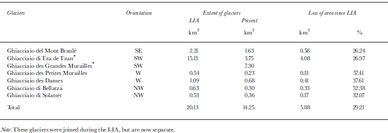
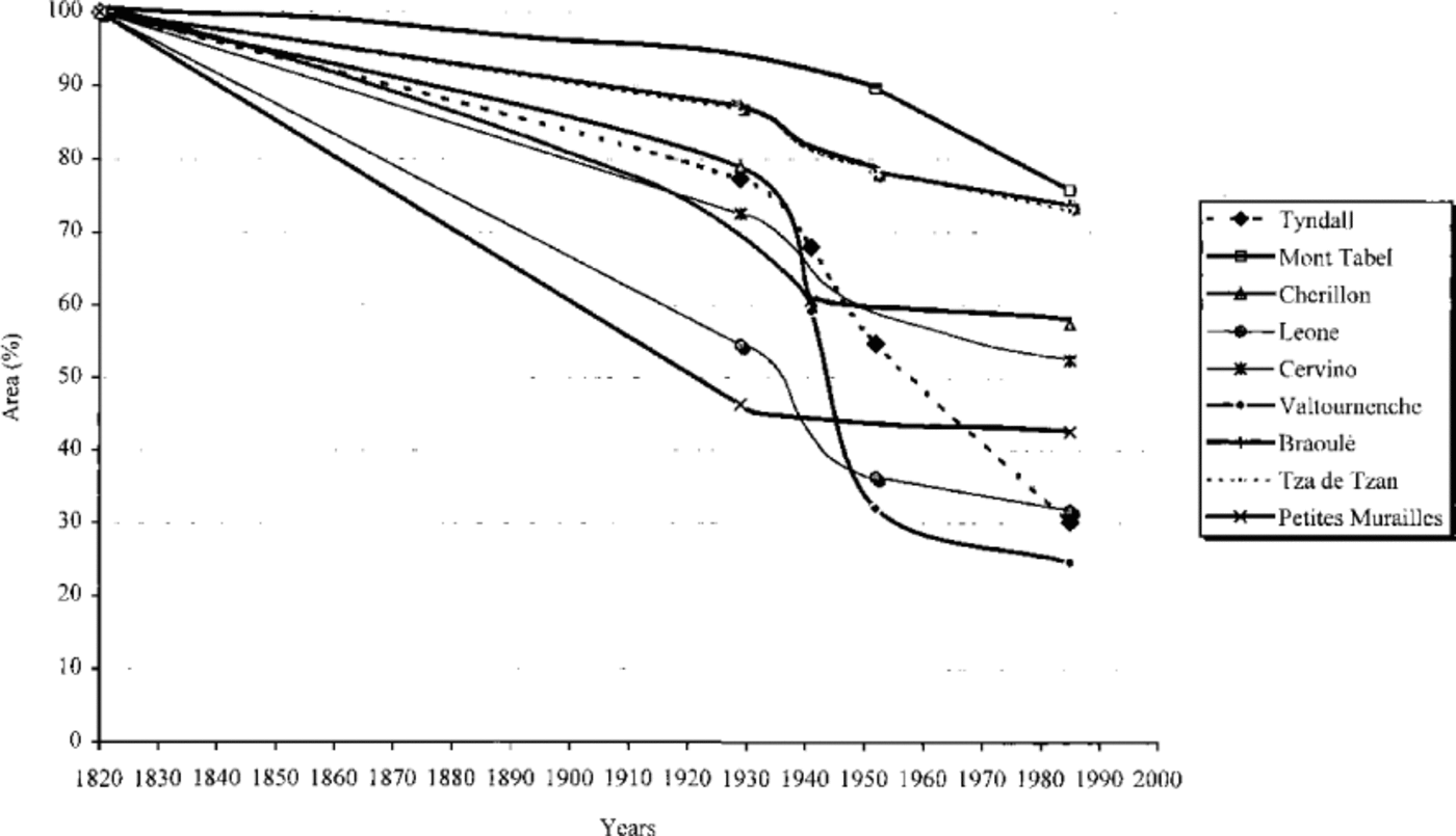
Fig. 8. Percentage areal retreat of some of the glaciers studied. For most, a fast retreat phase is evident from 1930-50, slowing from 1960-80.
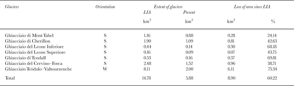
The overall retreat of glaciers at the head of Valtournenche was greater than that which affected those in Valpel line. The glaciers studied covered 14.78 km2 during the LIA maximum, whereas the present glacierized area is 5.88 km2, a loss of 8.9 km2 equalling 60.22% (Table 2). The Valtournenche and Teódulo glaciers, which together with the now extinct Gran Sommetta glacier made up a large single glacierized mass during the LIA, contributed most to this retreat. At the LIA maximum they occupied 8.11km2, but were reduced by 6.11km2 to 2 km2, losing 75.34% of their area. Such a high value can be explained by the morphology of both the bedrock and the glaciers themselves. As a consequence of the low gradient and of a relatively large area near the equilibrium line altitude (ELA), even a small change in mass balance was capable of causing considerable ice retreat.
Table 2. Changes in area of the Valtournenche glaciers.
The subsequent retreat phases of the Valtournenche glacier were deduced from historical maps (Reference LescaLesca and others, 1955) and are summarized in Figure 9. From early reports, it was also possible to reconstruct some stages of the recession of the Mont Tabel, Cherillon, Leone, Tyndall, Cervino-Forca and Teódulo-Valtournenche glaciers (Fig. 8). In total, the glaciers investigated in the upper Valpelline and Valtournenche valleys underwent a 42.34% retreat from their LIA maximum (1820) to the present (1981).
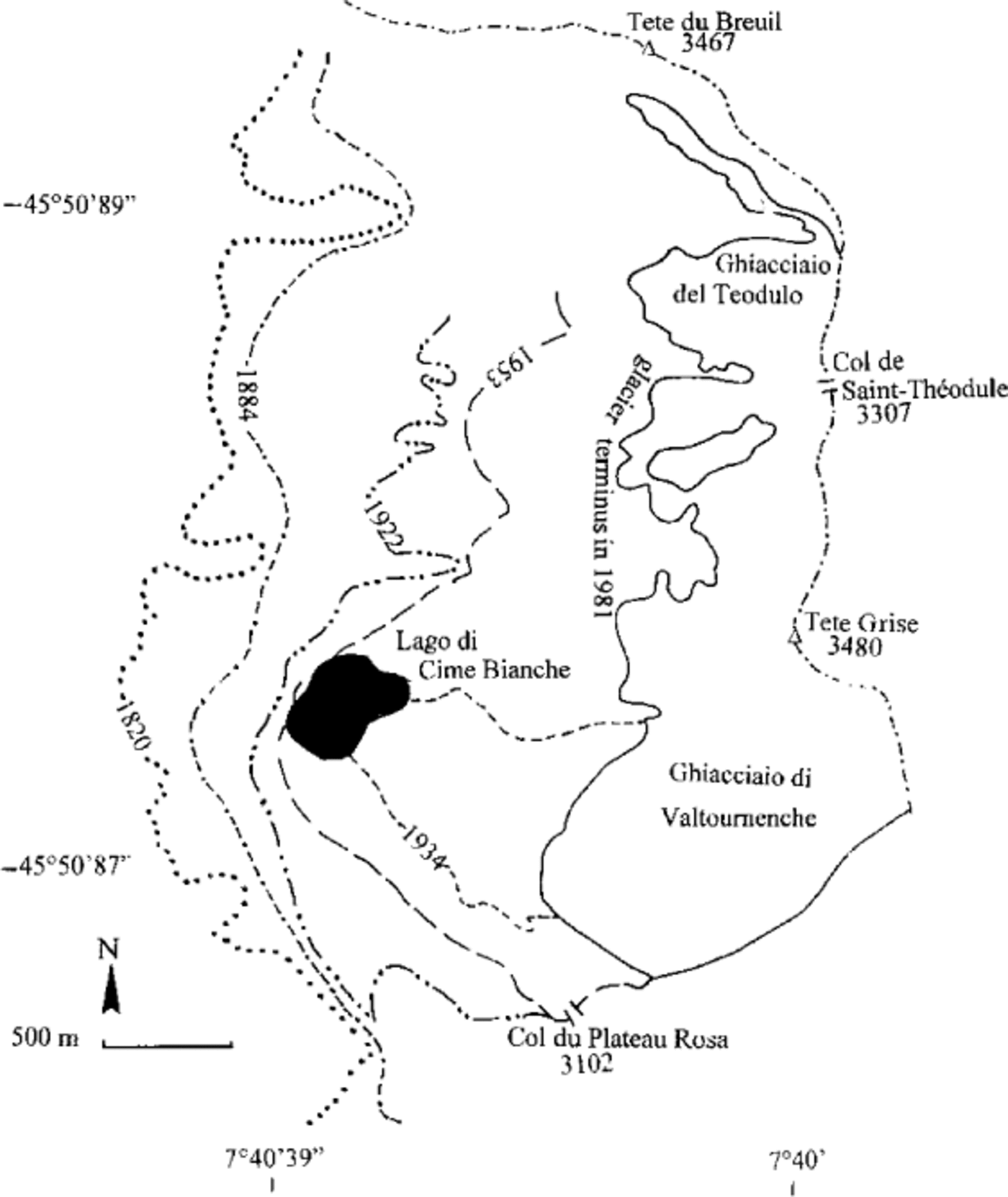
Fig. 9. Stages in the retreat of the Valtournenche glacier.
Volume Changes of the Valpelline and Valtournenche Glaciers
The use of a GIS has enabled volume changes affecting the Valpelline and Valtournenche glaciers to be calculated. By reconstructing the topography of each glacier during the LIA maximum, and by comparing it with the present situation, the volume difference over this period was assessed. Since no information is available on the bedrock, particularly ice thickness, the calculations were limited to the overall volume difference, not the total volume.
The data from the 17 glaciers analyzed show an ice-volume loss of 0.35 km3 from the LIA maximum to the present, equal to 0.315 km3 of water. Considering that the overall reduction in area of the glaciers studied was 14.78 km2, the average thickness of the ice melted must have been about 24 m.
The values are certainly underestimated. In fact, in the reconstruction of the glaciers, the topography of their accumulation areas was considered unchanged; only the lower area, corresponding to the ablation zone, was reconstructed. Thus, in calculating the volume change, the loss of ice taking place in the accumulation zone, mainly a thinning, was not assessed.
Paleoclimatic Consideration
The dynamic behaviour of a glacier depends on the temperature in the ablation season and on snowfall. The estimated mean annual temperature increase in Valle d’Aosta, from the LIA maximum to the present, is 0.8°C. This value has been deduced from the ELA rise of 143 glaciers located in Valle d’Aosta (Reference VanuzzoVanuzzo, 1995).
Conclusion
The general recessional trend of Alpine glaciers is one of the most evident of Nature’s indicators of the warming phase that started in the mid-19th century. The data here, even though local, confirm the trend generally observed for glaciers throughout Europe (Alps, Scandinavia), as regards areal, volumetric and linear retreat (Reference PelfiniPelfini, 1996; Reference MaischMaisch, 1992; Reference Haeberli, Muller, Alean, Bosch and OerlemansHaeberli and others, 1989).
For Alpine glaciers, the total loss of area, from 1850 to the mid-1970s, has been estimated at 50% of the original value (Haeberli, 1995). For the 17 glaciers investigated here, the calculated value is 42.34%. In the upper Valpelline, the glacierized area has gone from 20.13 to 14.78 km2, whereas for the upper Valtournenche a reduction from 14.78 to 5.8 km2 has been recorded. The estimated ice-volume loss was 0.35 km3.
Acknowledgements
The authors would like to thank G. Orombelli for his critical revision of the paper. The research was financed by the Murst 1997 programme: “Response of Geomorphological Processes to Environmental Changes” (national coordinator: A. Biancotti; local coordinator: G. Orombelli).


