

No CrossRef data available.
Article contents
Extract
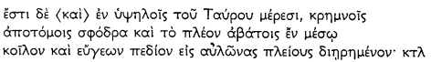
An inscription giving the name of this otherwise unknown community was discovered by J. R. S. Sterrett in the West Taurus Lake District, during his 1885 Wolfe Expedition, in the large village of Ortakaraviran, which lies north-east of Suğla Gölü (the ancient Trogitis lacus), on low ground close to the Lake.
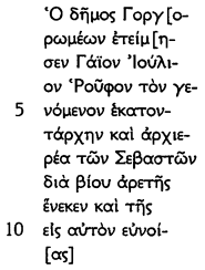
The text of the inscription records that:
- Type
- Research Article
- Information
- Copyright
- Copyright © The British Institute at Ankara 1971
References
2 Published as Papers of the American School of Classical Studies at Athens, Vol. III (1888)Google Scholar, “The Wolfe Expedition to Asia Minor”, (quoted as WE.).
3 See Fig. 1 (drawn by my colleague, Mr. A. L. F. Rivet) and Fig. 2 (based on the 1:200,000 Konya and Beyşehir sheets published in Ankara by the Harta Genel Müdürlüǧü). Since 1965 the waters of Suǧla Gölü have expanded to reach its original shore-lines, after several years during which the bed of the Lake had been almost completely dry. The Lake has remained at this level, and profitable fishing has been resumed by the villagers of Yalı Hüyük. See the remarks of the present writer on an earlier controversy over the extent of Gölü, Suǧla, in AS., XVIII (1968), “Notes and Inscriptions from Eastern Pisidia”, p. 57Google Scholar, n. 2.
4 Sterrett, J. R. S., WE., p. 129, no. 217Google Scholar.
5 He may have been commander of the local detachment of stationarii (see Section VI). For another C. Iulius Rufus not far away, see a Latin inscription at Hatunsaray (BCH., vii, (1883), p. 317Google Scholar = CIL., III, 6791Google Scholar = J. R. S. Sterrett, WE., no. 248 = MAMA., VIII, no. 13). The name Rufus is common around Lystra.
6 Seen in 1957 in the same place and condition.
7 See Fig. 2. The two villages are about 5 km. apart. Akkisse lies in a fold of higher ground almost due east of Ortakaraviran. It is now a large village, with its own Belediye. See Plates Va and b for views across Akkisse towards the other village, taken from the ancient site.
8 This is the former name of the ancient site, which lies on a hill-top about 1 km. east of Akkisse.
9 See Fig. 2. The present name of Gulghurum, until recently Ararım, is now Gokçimen.
10 Sterrett, WE., no. 240.
11 The extensive site at Namze yaylası was re-examined in 1970. The results will be published elsewhere.
12 Kiepert, H., Kleinasien 1:400,000 (1902–1906)Google Scholar, Konya sheet. A part of this map, showing “Gorgorome”, is reproduced as Planche XXXVI in Robert's, L.Hellenica XIII, (1965)Google Scholar.
13 Sterrett, WE., Endpapers, “Routes made in August and September 1885 by Dr. J. R. S. Sterrett in ancient Isauria constructed from his observations and measurements by Henry Kiepert, Berlin 1886, Scale 1:300,000.”
14 IGR., III, p. 129, no. 280Google Scholar, where he comments: “Gorgorome, urbs Isauriae hactenus ignota, quam Sterrett putat non longe a Kara-Viran sitam, in loco hodie dicto Goulgouroum.”
15 RE., Vol. VII, cols. 1659–1660.
16 Jüthner, /Knoll, /Patsch, /Swoboda, , Vorläufiger Bericht über eine archäologische Expedition nach Kleinasien, Prague (1903), pp. 26–27Google Scholar.
17 JRS., XIV (1924), p. 50, Fig. 15Google Scholar.
18 The same positions are given to both places on the map facing p. 28, where, in addition, Misthia is wrongly placed: see AS., IX (1959), pp. 119–124Google Scholar, “The site of Misthia”.
19 Continuing and extending work undertaken by the writer in 1957, 1958 and 1961 in Eastern Pisidia and Isauria. Material from Eastern Pisidia has been published in AS., XVIII (1968), pp. 57–92Google Scholar.
20 The numbers inside brackets are Catalogue numbers corresponding to entries in the writer's field note-books.
21 This name is no longer in use.
22 It may indeed be true that the settlement of the Gorgoromeis was named “Gorgorome”. But no evidence exists to confirm this assumption.
23 Local examples of stationarii: (1) at Kireli, on the shores of Beyşehir Gölü, north-west of Beyşehir (IGR., III, no. 242, discussed by Robert, L. in Hellenica XIII (1965), p. 80Google Scholar, where a bibliography of the relevant literature is given); (2) at Vasada (Swoboda, /Keil, /Knoll, , Denkmäler aus Lykaonien, Pamphylien und Isaurien, Prague (1935)Google Scholar, (quoted as Denkmäler), p. 24, no. 34; (3) a second new example from Akkisse recorded below (no. 2); and (4) in the Calycadnus valley at Artanada (Dulgerler), (Sterrett, WE., no. 73). For the form στατιωνάρις see Inscriptiones Graecae in Bulgaria repertae, II (1958), no. 855Google Scholar.
24 Buckler, /Calder, /Cox, , JRS., XIV (1924), p. 76, no. 110Google Scholar.
25 A single name identifies the dedicator at Vasada, in my view.
26 Denkmäler, p. 24, no. 34, with discussion.
27 Material from this ancient site, which has now been largely denuded of visible remains, is heavily concentrated in the Lakeside village of Yalı Hüyük (see Fig. 2). A collection will be published elsewhere. The name of the ancient site in antiquity is so far unknown.
28 For a possible line for this section of the road, see Fig. 2.
29 Plates Va and b show the areas of low ground towards the Lake south-west and west from the ancient site. The village in the foreground is Akkisse; those in the middle distance are the Kara Virans. Plate VIa (unfortunately of poor quality) shows part of the ancient site itself; it was taken from the summit of Karatepe, looking south-westwards.
30 Sterrett, , WE., pp. 139–140, no. 240Google Scholar.
31 If ṬH represents the number 308, then the question which presents itself is to what sequence of numbers this boundary stone belongs. Can it be one of a series defining an Imperial estate, perhaps the confiscated territory of the Homonadeis? If so, why have no other members of this series been found?
32 (1) Hamilton, W. J., Researches in Asia Minor, Pontus and Armenia, Vol. II (London, 1842)Google Scholar; (2) J. R. S. Sterrett in 1885 (The Wolfe Expedition); (3) Calder and Cox in 1924; (4) and (5) visits by the present writer in 1957 and 1970; (6) See Addendum.
33 Sterrett's remark, quoted on p. 128, should be recalled at this point.
34 Three of the monuments recorded here were later removed to the Konya Archaeological Museum; these are no. 16, and (a) and (q) among the uninscribed.
35 For various forms, see Zgusta, L., Kleinasiatische Personennamen, Prague (1964) (quoted as Zgusta, KP.), 466–7Google Scholar, where a slightly uncertain example of Ιμμοας in a genitive form is listed from Swoboda/Keil, Denkmäler, no. 95. This monument, reviewed in 1961, and built into the base of the mosque in the village of Kıstıfan, near Beyşehir, has clearly been brought from the hill country further south. For a female version of the name, see now Bean, G. E. and Mitford, T. B., Journeys in Rough Cilicia, 1964–1968 (Denkschrift of the Austrian Academy of Sciences, no. 102), (1971) (quoted as Bean/Mitford, Journeys), p. 118, no. 104Google Scholar, from Tosuntaşı in “Isauria”. If my argument below is correct, Tosuntaşı will in fact have lain within the territory of the Homonadeis.
36 The significance of the use of Latin and the frequency of Roman names in this district is discussed in Section VI below. Since AL cannot be regarded as an abbreviation, I read here the unexampled ALLVCIVS, with which Miss Levick helpfully compares the name ![]()
![]() from near Karaaǧaç, in the Cillanian Plain, first published by Calder, /Cormack, in M.A.M.A. VIII, no. 367Google Scholar and identified as Thracian by Robert, L. in Noms Indigènes dans l'Asie Mineure gréco-romaine (Paris, 1963), p. 114Google Scholar.
from near Karaaǧaç, in the Cillanian Plain, first published by Calder, /Cormack, in M.A.M.A. VIII, no. 367Google Scholar and identified as Thracian by Robert, L. in Noms Indigènes dans l'Asie Mineure gréco-romaine (Paris, 1963), p. 114Google Scholar.
37 But see Zgusta, , KP., 732–2Google Scholar: Κουνδις, Κουνδιος.
38 For Ιμμαθις see Zgusta, , KP., 466–11Google Scholar, from Kassaba (the modern Kazım Karabekir, on the main road between Çumra and Karaman) and compare Ιμματις from this site (Zgusta, , Neue Beiträge zur Kleinasiatischen Anthroponymie, Prague (1970) (quoted as Zgusta, Neue Beiträge,) p. 33Google Scholar = CIG., 4397 = Hamilton, no. 445) with another instance at Dinek Beleni (near the modern Dinek) on the road from Çumra to Hadim.
For Ιννεις see Zgusta, , KP., 471–4Google Scholar. The present instance provides confirmation of the nominative form.
39 For Οπραμωσις see Zgusta, , KP., 1099–7Google Scholar (from Korykos in Cilicia). Κόννις is firmly identified as Greek by Zgusta, , both in KP., p. 255, n. 217aGoogle Scholar, and in Neue Beiträge, p. 50, 791, where he suggests that it may have been equated with Κωννις.
40 But see Αλλας, in Neue Beiträge, p. 12–13, 52–3Google Scholar, from Adanda (Cilicia); Ελας from this site (WE., no. 214); and cf. Αλαικας, in Bean, /Mitford, , Journeys, p. 178, no. 197Google Scholar, from Direvli in Cilicia.
41 Well known in this district: see AS., XVIII (1968), p. 84, no. 41Google Scholar= Neue Beiträge, p. 44, 607–9a; and an unpublished example of Κιλλαρις from Yalı Hüyük (1970/63).
42 But see Zgusta, , KP., 1189–1Google Scholar Παθις from Palaia Isaura; and 1189–2 Παθθοον from Astra.
43 For Κιδας see Zgusta, , KP., 602–1Google Scholar; for Κιδασις, KP., 602–4Google Scholar; for Κιβαλις, KP., 599–1Google Scholar for Κιβλις, KP., 599–2Google Scholar.
44 See the list given by Buckler, /Calder, /Cox, in JRS., XIV (1924), p. 68Google Scholar.
45 Zgusta, , KP., 1463–4; 1463–5; 1463–9; 1463–10Google Scholar.
46 Ορμους, KP., 1106–2Google Scholar; Μουας, KP., 978Google Scholar, and many compounds.
47 Zgusta, , KP., 83–1Google Scholar, mainly from Palaia Isaura.
48 Now in the Konya Archaeological Museum.
49 Also in the Konya Archaeological Museum.
50 In some cases where no facsimile is offered, a poor photograph of the object exists in the writer's possession, as here.
51 Levick, B., Roman Colonies in Southern Asia Minor (Oxford, 1967) (quoted us Roman Colonies), p. 17Google Scholar.
52 Strabo, XII, p. 569 f.
53 Pliny, , N. H., V, 94Google Scholar.
54 First of all by Ramsay, in The Historical Geography of Asia Minor, (1890), p. 335 and 419Google Scholar. His subsequent revisions of these views and the opinions of other scholars are conveniently summarised by MissLevick, in Appendix V of Roman Colonies, p. 203–214Google Scholar, who gives as her own view (p. 206): “There is only one area which will satisfy the requirements of all the evidence. That is on the southern shore of Lake Trogitis, the plain to the south of the lake towards Bozkır and the mountain ridge to the south-west in the direction of Cotenna, which is always ascribed to Pamphylia.”
55 Two pieces of evidence support this view. (1) The well-known passage of Strabo (XII, p. 569 f), which follows his account of the reduction of the Homonadeis by Quirinius, has generally been taken to describe their homeland:
Most editors have removed καί from the beginning of this sentence. If, however, καί is restored, it becomes clear that Strabo is describing another part of the territory of the Homonadeis, high up in the mountains south of Suǧla Gölü, where the Sülek Alanı corresponds well with his description. The absence of any mention of Trogitis lacus (which is named earlier—p. 568—alongside Karalis) appears to me to rule out the possibility of making this passage a general description of the homeland of the Homonadeis. (2) The area left desolate by Quirinius will have been the densely populated area around the Lake, from which the united people derived the main bulk of their grain supplies. When they were driven from it into the surrounding hills, north and south, Quirinius had merely to wait for starvation and the snows of winter to take their effect. And this was precisely the course of his campaign. When the starving warriors had surrendered, they were resettled outside the district, dispersed to “neigh-bouring cities”. Were they ever allowed to return?
56 Jones, A. H. M., Cities of the Eastern Roman Provinces (2nd ed. 1971), p. 137Google Scholar: “… the Sedaseis were thus one among several ‘peoples’ of the ‘tribe’ of the Homonadeis”. Here Jones relies on the term όμοέθνεις, giving it a meaning which I believe to be unjustified. His conclusion, however, may be correct, even if his assumption is not. He continues: “How many peoples there were we do not know but Pliny records that the Homonadeis possessed forty-three forts besides their central stronghold Omana, and each of these forts may have been the centre of a clan or ‘people’”.
Levick, B., Roman Colonies, p. 17Google Scholar: “There can be little doubt that, down to the intervention of Augustus, the social organisation of this area was a fairly homogeneous one of war-like tribes ruled by petty chieftains, with a sprinkling of superficially hellenized cities.”
57 The citations are listed by MissLevick, on p. 204 of Roman ColoniesGoogle Scholar.
58 For the status of the Orondeis, see Robert, L., Hellenica, XIII (1965), p. 82–84Google Scholar.
59 Levick, B., Roman Colonies, p. 51Google Scholar: “It was Ramsay's opinion that all six of the colonies were intended for the suppression of the Homonadenses; this number should be reduced to one: Lystra”.
60 Well expressed by Ramsay, W. M. in JRS., XII (1922), p. 148Google Scholar, as a debt of vengeance, since Augustus was heir to Amyntas.
61 Claudiomistea, : AS., IX (1959), p. 119–124Google Scholar; Claudiconium, : IGR., III, 246Google Scholar; and Claudioderbe: Babelon, E., Inventaire sommaire de la Collection Waddington, 4758Google Scholar.
62 Named Pappa Tiberiopolis thereafter.
63 Hamilton, W. J., Researches in Asia Minor, etc. Vol. II, no. 442Google Scholar = CIL., III, 6799Google Scholar. The stone is now built into the mosque of Sandı Köy, near Yalı Hüyük, and was seen in 1970.
64 The most obvious example is ![]() .
.
65 Several are unrecorded: ![]()
page 160 note 1 Hamilton, W. J., Researches in Asia Minor, Pontus and Armenia, Vol. II (London, 1842)Google Scholar.
page 160 note 2 Sterrett, J. R. S., Papers of the American School at Athens, Vol. III, 1885Google Scholar, The Wolfe Expedition.
page 160 note 3 Buckler, /Calder, /Cox, , JRS., XIV (1924), pp. 50–84Google Scholar.
page 160 note 4 Supplementum Epigraphicum Graecum, Vol. VI.
page 160 note 5 Also recorded in Studies in the History and Art of the Eastern Provinces of the Roman Empire, ed. Ramsay, W. M. (Aberdeen, 1906), pp. 333–7Google Scholar, no. 5.
page 160 note 6 Also recorded in Année Epigraphique, 1926, p. 33, no. 74Google Scholar.
page 161 note * Drawn from all the inscriptions listed in Fig. 3, including those published here for the first time, but not including the Addendum. The latest reading is the one adopted, with some further emendations which are noted.
page 162 note 1 Sterrett read ![]() . I prefer
. I prefer ![]() .
.
page 162 note 2 Sterrett read ![]()
page 162 note 3 Zgusta, KP., cannot decide between Καρβαρας and κ(ὲ) Αρβαρας.
page 162 note 4 See note1 above.
page 162 note 5 See note2 above.
page 162 note 6 It seems likely that Ἰούλι[ο]ς should be read here.
page 162 note 7 Zgusta, , KP., 466–8Google Scholar and n. 68.
page 162 note 8 Revised by Zgusta, in Neue Beiträge, p. 33, 466–10Google Scholar, upon a suggestion by Dr. Pascher-Laminger.
page 163 note 9 As emended in note 6 above.
page 163 note 10 See Zgusta, , KP., 599–1Google Scholar and 2, both from “Isauria”.
page 163 note 11 See Zgusta, , KP., 602–1 and 4Google Scholar; and Neue Beiträge, p. 43, 602–8.
page 163 note 12 Zgusta, , Neue Beiträge, p. 23, 224Google Scholar.
page 163 note 13 Nothing in Sterrett's published version requires restoration of a mu at the beginning of the line in question. Cox and Calder had doubts, and were in favour of reading another mu to replace the first alpha. A possibility of AMA remains.
page 165 note 14 Zgusta, , Neue Beiträge, p. 66, 1013–1Google Scholar.
page 165 note 15 See Zgastz, , Neue Beiträge, p. 84, 1295–5Google Scholar.