


As an Indigenous people, the Huron-Wendat value archaeological investigation of their ancestral sites. Archaeology, when conducted collaboratively with the Huron-Wendat, is considered an important source of information about their ancestors. At the same time, they believe that ancestral sites should be protected, conserved, and disturbed only with good reason. Traditionally in Ontario, Huron-Wendat village sites are discovered, delimited, and sampled by shovel test pits and excavation of 1 m units. On ploughed sites, topsoil is mechanically stripped by heavy equipment to reveal underlying features that are recorded and excavated. Once discovered, further investigation often involves complete block excavation of midden areas. While extremely effective, these approaches are highly intrusive and have the potential to disturb human remains.
In accordance with the wishes of the Huron-Wendat to avoid traditional large-scale archaeological excavations, we adopted minimally invasive field methods that were applied during a field school at the Ahatsistari site (BeGx-76), a seventeenth-century Huron-Wendat village in Simcoe County, Ontario. Our minimally invasive approach avoids block excavation and the stripping of topsoil in favor of surface survey and geophysical prospection (i.e., magnetic susceptibility and metal detector) to determine the limits and internal structure of the site, and to guide limited test excavation of 1 m units in middens. All excavated deposits were water-sieved through 1.6 mm mesh for maximum recovery of artifacts and ecofacts. Previously excavated but unanalyzed collections (i.e., archived) were incorporated into the study along with information from rich historical and archaeological records that are the result of data collected from over a century of investigations of Iroquoian village sites. This approach resulted in limited disturbance to site deposits.
These field techniques were part of an integrated archaeological research design involving collaboration among archaeologists, geophysicists, historians, and descendants. Our close consultation with and involvement of the Huron-Wendat when paired with minimally invasive strategies is a positive step toward a sustainable archaeology in Ontario. This approach addresses descendant-community concerns regarding the destructive nature of archaeological excavation by helping to conserve archaeological sites in situ. It also serves to engage field-school students in the broader political and philosophical context of our work at Tay Point and is thereby helping to train the next generation of archaeologists in reflexive, culturally sensitive analytical methods. Similar strategies can be applied by other projects, enabling a shift from the current “extractive, consumptive paradigm” that dominates archaeological practice in the province (Ferris and Welch Reference Ferris, Welch, Atalay, Claus, McGuire and Welch2014) and bringing it more in line with the conservation ethos that underlies the ethical principles of the Society for American Archaeology (SAA), Canadian Archaeological Association (CAA), and the Ontario Archaeological Society (OAS) (cf. Hodgetts et al. Reference Hodgetts, Millaire, Eastaugh and Chapdelaine2016).
HURON-WENDAT COMMUNITIES AND ARCHAEOLOGY
Nicholas (Reference Nicholas2008) describes Indigenous archaeology as “an expression of archaeological theory and practice in which the discipline intersects with indigenous values, knowledge, practices, ethics, and sensibilities, and through collaborative and community-originated or -directed projects, and related critical perspectives.” Implicit in this practice is Indigenous control of and access to cultural and intellectual property, and where archaeologists are employees or consultants for the descendant community (Colwell Reference Colwell2016; Colwell-Chanthaphonh and Ferguson Reference Colwell-Chanthaphonh, Ferguson, Colwell-Chanthaphonh and Ferguson2008). In Ontario, Indigenous control of the archaeological past is unfortunately not on the immediate horizon because of the structure of current legislation. The Ontario Heritage Act, R.S.O. 1990, c. 0.18 (2009) places the authority to conduct archaeological investigations and care for recovered artifacts and data in the hands of licensed archaeologists who are sanctioned by the Province of Ontario. While archaeologists are encouraged to engage with Indigenous communities in Stage 3 and Stage 4 of a project for the purpose of addressing descendant-community interests (as laid out in a recent set of guidelines, Engaging Aboriginal Communities in Archaeology issued by the Ministry of Tourism, Culture and Sport 2011), provincial standards in compliance archaeology (i.e., CRM) demand test excavation at the site-assessment stage even when there is opposition by Indigenous communities who wish little or no disturbance of ancestral sites.
The Huron-Wendat (and Wyandot) and other Indigenous groups have struggled to monitor and protect their archaeological heritage in Ontario. Prior to the early 2000s, the Huron-Wendat were generally not consulted (although there are a small number of exceptions) about archaeological investigation of ancestral sites. In fact, digging of ancient Huron-Wendat sites is noted as early as the 1850s with Jesuit-directed excavations of ossuaries in Simcoe County (Jones Reference Jones1908). Unsanctioned excavations of Huron-Wendat sites began in earnest in the 1940s and 1950s, under the direction of Kenneth Kidd and Wilfrid Jury, who targeted seventeenth-century ossuaries and villages, and the Jesuit mission of Ste. Marie (Trigger Reference Trigger2001:5). In the decades since, further testing and areal excavations of precontact and contact Huron-Wendat villages have been carried out as CRM, research, and field-school projects. Over a century of fieldwork on dozens of Huron-Wendat sites in southern Ontario has produced tremendous numbers of artifacts and human remains (Williamson Reference Williamson2014).
Over the last three decades, the Huron-Wendat have demanded and received increasing influence over their archaeological heritage in Ontario, especially human burials. A turning point for many Indigenous descendant communities in Canada was defined by the Oka Crisis of 1990 involving a dispute over sacred burials in a pine forest between the Mohawk of Kanesatake and the town of Oka, Quebec. The post-Oka political climate of the 1990s led to the repatriation and reburial in the summer of 1999 of over 400 Huron-Wendat ancestors in the Ossossane Ossuary (Kapches Reference Kapches2010). Throughout the first decade of the twenty-first century, the Huron-Wendat have become increasingly protective and outspoken about the excavation of archaeological village sites in southern Ontario in advance of development, and, in the fall of 2013, another 1,760 Huron-Wendat ancestors were reinterred at the Thonnakona (Kleinburg) Ossuary, in the vicinity of the Skandatut site, an early seventeenth-century Huron-Wendat village on the outskirts of Toronto (Pfeiffer and Lesage Reference Pfeiffer and Lesage2014; University of Toronto 2013).
These recent events have brought about a fundamental change in the way archaeology is conducted in Ontario and have also enabled a shift toward even greater Indigenous control of their heritage. Sustainable archaeology practices that advocate reimagining archaeology in accordance with the wishes of descendant communities, the avoidance of site excavation, and the study of existing collections (Ferris and Welch Reference Ferris, Welch, Atalay, Claus, McGuire and Welch2014:231–233) are gaining momentum. Archaeology on Huron-Wendat sites is now carried out in close collaboration with the Huron-Wendat. Delegates of the Huron-Wendat concerned with the administration of archaeology in Ontario are not opposed to archaeological work on Huron-Wendat cultural sites. They wish to be involved, to collaborate with archaeologists, to orient, and to ensure that any investigation contributes to a better understanding of the life and times of their ancestors. The Huron-Wendat wish to be active participants in the creation of knowledge that combines traditional knowledge with archaeological research through the exchange of ideas and questions, and to be involved in archaeological research by partnering with archaeologists and coauthoring and contributing to publications. Louis Lesage, Director of the Nionwentsïo Office (Lands and Resources), Huron-Wendat Nation, views collaborative research as a modern expression of the win-win situation of alliances recognized in ancient times. Lesage notes that Huron-Wendat ancestors may be proud to allow some archaeological work done on chosen sites in an effort to understand their past world and are probably even prouder to see that their descendants are part of these discoveries.
A CASE STUDY IN MINIMALLY INVASIVE AND SUSTAINABLE ARCHAEOLOGICAL STRATEGIES FOR INVESTIGATING VILLAGE SITES: 2014 WILFRID LAURIER FIELD SCHOOL AT AHATSISTARI
The Tay Point Archaeology (TPA) project in Penetanguishene, Ontario, Canada (Figure 1), is focused on a single Huron-Wendat community represented by several large village sites believed to be sequentially occupied over a 250-year period (A.D. 1400–1651). Tay Point offers an ideal setting to examine first settlement by Huron-Wendat in precontact times to the European arrival and eventual relocation of the Huron-Wendat in the mid-seventeenth century. Historical maps also indicate that there is a strong possibility that two of the village sites, Ahatsistari (formerly Allen Tract; BeGx-76) and Chew (BeGx-9), are the remains of Carhagouha and Quieunonascaran respectively, villages visited and described in the early seventeenth century by Joseph Le Caron, Samuel de Champlain (Biggar Reference Biggar1922–Reference Biggar1936), and Gabriel Sagard (Wrong Reference Wrong1939).
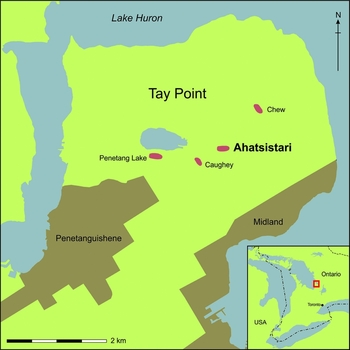
FIGURE 1. Map showing southern Ontario and the location of Tay Point.
In 2013, a meeting between Chief Line Gros-Louis, Louis Lesage, Simon Picard, and Melanie Vincent of the Huron-Wendat Nation and Gary Warrick and Bonnie Glencross of Wilfrid Laurier University (WLU) was held to discuss a multiyear program of archaeological research and to propose the application of a minimally invasive approach to investigations of village sites on Tay Point. Our approach is founded in sustainable archaeology practice with an emphasis on the use of noninvasive and minimally invasive strategies and intensive recovery techniques in the field. In 2014, investigations at Ahatsistari, and the analysis of an archived collection from the Chew site, were conducted through a WLU field school.
Minimally Invasive Strategies: Surface Survey, Magnetic Susceptibility Survey, Metal Detection, and Limited Test Excavation
Surface Survey
Pedestrian survey was conducted at Ahatsistari to investigate the extent of the site and internal organization of the village by identifying midden areas. While setting up grid baselines prior to the field school, seven midden areas were identified by brushing aside leaf litter and examining the forest floor for very dark soil containing faunal bone and artifacts. During the field school, a student pedestrian survey identified an additional seven middens. The majority of the 14 identified middens circle the site and appear to indicate the extent of the Huron-Wendat village (Figure 2); middens were found along the banks of Sucker Creek in the north, the slope marking the east side of the forest tract, and the edge of Tay Point road to the south. Still to be delimited is the western boundary of the village, which appears to extend beyond the fence line marking the western border of the property.

FIGURE 2. Location of magnetic susceptibility survey area.
Magnetic Susceptibility Survey
Magnetic susceptibility survey was used to map the extent of the site, including the number and distribution of longhouses identified by their hearth alignments. The survey guided subsequent shovel test pitting and 1 m unit test excavation. This approach had been applied successfully (Hodgetts et al. Reference Hodgetts, Millaire, Eastaugh and Chapdelaine2016; Millaire et al. Reference Millaire, Eastaugh, Hodgetts and Chapdelaine2015) at the Mailhot-Curran site in Quebec, a sixteenth-century St. Lawrence Iroquoian site, where magnetic susceptibility identified the site limits, longhouse floors, and the central hearths of six longhouses. We used a Bartington MS3 magnetic susceptibility meter with MS2D surface scanning probe, which measures susceptibility per unit volume. This approach was chosen over other geophysical prospection methods because, like Mailhot-Curran, Ahatsistari is located within a woodlot and the extensive tree cover hampers the use of other geophysical techniques such as magnetometry (Hodgetts et al. Reference Hodgetts, Millaire, Eastaugh and Chapdelaine2016).
In May of 2014 and 2015, we surveyed a total of 7,500 m2 over eight days. A survey grid (Figure 2) was established over the site using a total station theodolite, and readings were logged at 1 × 1 m intervals. Thirty-meter tapes were used to ensure accurate distance between traverses and logged readings. The readings were downloaded using Bartsoft software and imported into ArchMap, where they were converted into interpolated surfaces using the inverse distance weighting function. The recorded readings are expressed as susceptibility per unit volume within the International System of Units (SI). The results of the survey (Figure 3) show bands of high susceptibility running diagonally across the site from northeast to southwest. Within this trend are numerous smaller lozenge-shaped anomalies of high susceptibility. Initial assessment of the results appeared to indicate that the survey successfully identified longhouses across many parts of the site, including their hearth alignments, as the results were almost identical to those observed at Mailhot-Curran (Figure 4). However, excavation to ground truth four of the anomalies at Ahatsistari identified only a single concentration of fire-cracked rock in one of the units (Figure 3). All the other units were devoid of features or other evidence of burning.

FIGURE 3. Results of magnetic susceptibility survey.

FIGURE 4. Detail of northern survey area at Ahatsistari showing the similarity of results to those obtained for longhouses at Mailhot-Curran (inset).
We do not yet fully understand the reason for the lack of correspondence between anomalies and archaeological features, as further testing was ruled out to minimize disturbance in accordance with the wishes of the Huron-Wendat. However, most of the anomalies are likely the result of the underlying geology, since the large diagonal bands of susceptibility highs match the position and orientation of the glacial till terraces that run across the site. Although the survey clearly identified some archaeological features, as indicated by the single positive test unit, the strong background variability produced by the local Pleistocene geology obscured the smaller, more ephemeral responses that we might anticipate from archaeological features. This is a significant finding for Huron-Wendat archaeology in Huronia, as most village sites are located on glacial till ridges (Heidenreich Reference Heidenreich1971). More work is needed in the area to assess whether the entire region is unsuitable for this type of prospection or whether its applicability is dependent on local conditions. There are well-documented challenges in employing magnetic geophysical methods in regions with underlying igneous rock (Clark Reference Clark1990) or where igneous rocks comprised of different parent material than the local substrate are deposited on a site through glacial action (Hodgetts et al. Reference Hodgetts, Dawson and Eastaugh2011), since these geological features produce a lot of “noise” in the results.
Magnetic susceptibility surveys are often followed by a more detailed magnetometry survey; however, at Ahatsistari the forested site conditions made this impractical. While untested on Tay Point, geophysical prospection combined with geochemical analyses may be another approach worth investigating. Geophysical prospection has been combined with geochemical analyses to infer settlement structure at sites located in the southwestern Lake Erie Basin and the midwestern USA (Nolan and Redman 2015; Roos and Nolan Reference Roos and Nolan2012). Birch (Reference Birch2016) reports the identification of longhouses and a palisade at the Spang site, a late fifteenth-century Iroquoian village located in Ontario, using geophysical survey and geochemical analyses, but has yet to confirm her interpretations through excavation.
Metal Detector Survey
While rarely used on European-era Indigenous sites in North America, metal detector survey has enormous potential and presents a minimally invasive means of determining the location, distribution, quantity, and material of European metal artifacts. It has proven particularly effective on battlefield sites (Wagner Reference Wagner2006) and for establishing site limits, as well as identifying buried middens and historic structures (Connor and Scott Reference Connor and Scott1998).
In 2014, students conducted a metal detector survey of three areas at Ahatsistari site using a Teknetics Delta 4000 metal detector. The northern area was surveyed beyond the most westerly visible midden to establish the metal detector's ability to identify the western edge of the site. The central area was surveyed to establish the “average distribution” of metal objects for the site as a whole, and the southern area was positioned over a visible midden to establish the signature of other buried middens. Using 10 m by 10 m blocks that were divided into 1 m wide traverses, metal detector readings were taken continuously along each transect. Students detected 198 metal responses across the three areas, including both iron and copper objects (Figure 5). Although not all of the responses were verified by excavation, in all instances where the find spot fell within an excavation unit, the material type was confirmed and the metal dated from the historic period and was of European origin.

FIGURE 5. Metal detecting results.
The results confirm the utility of the technique for identifying the limits of historic-period villages. Our northern survey area clearly shows the rapid drop-off of find locations beyond the western most visible midden. Given that metal items are located across the central survey area, we believe that the decline in responses in the north survey area marks the northwestern extent of the site. A shovel test pit survey of the same area, conducted in 2013 by Laurentian University, reports a rapid decline in the number of positive shovel test pits (Hawkins Reference Hawkins2014) suggestive of the limits of the village. The distribution of find locations in the central area is intriguing, with responses, particularly iron, showing marked clusters in the north, west, and south portions. While the cluster in the west represents an identified midden mound, the clusters to the north and south may indicate the locations of longhouses. Although metal detecting confirmed the presence of metal in the central portion of the site, looting in this area makes it unclear how well our observed distribution reflects the original density or distribution of finds. The southern survey area, as expected, identified a dense cluster of find spots associated with the midden mound. This indicates that further buried middens would be readily identified and distinguishable from other parts of the site through systematic metal detecting.
Limited Test Excavation
In keeping with our focus on minimally invasive investigation methods, the 2014 field school excavated 13 1 m2 test units in seven middens in order to recover a full spectrum of artifacts and ecofacts. Middens were targeted because they are easily identifiable, are distributed throughout the village, contain the majority of artifacts and ecofacts, and Huron-Wendat middens generally do not contain human burials. Archaeologists customarily excavate Huron-Wendat middens in their entirety to recover material culture and zooarchaeological and archaeobotanical remains (e.g, Ball site [Knight Reference Knight1987]). This method is not only labor-intensive and time consuming, but also results in substantial damage to a site and its archaeological deposits (Stein Reference Stein1986). To compensate for the small number of test units excavated, we adopted intensive recovery techniques to collect as much data as possible.
Intensive Recovery Techniques: 100 Percent Recovery and Wet Sieving
The wet sieving of 100 percent of the excavated soils through 1.6 mm mesh provides valuable insight as to what is usually missed with standard sieving practices (¼ in or 6 mm mesh). Most middens at Athatsistari were looted by artifact hunters who mostly collected large objects, leaving small artifacts and ecofacts in the backdirt. Despite the diminution or lack of certain diagnostic artifact classes (e.g., large pottery rim sherds, clay pipe bowls, iron axes, and knives), the intensive recovery techniques provided sufficient numbers of artifacts and ecofacts to establish site age, and information on subsistence practices and the historical environment. A date of ca. A.D. 1600–1625 based on glass bead chronology (Hawkins Reference Hawkins2014) matches the historically referenced occupation of Carhagouha, securing Ahatsistari's place in the village relocation sequence for Tay Point. The nature and number of European artifacts suggests a strong European presence and widespread trade with the French and other Indigenous groups in the north and along the Atlantic Coast (Glencross Reference Glencross2016).
The contributions to the reconstruction of subsistence and the historic environment from wet sieving using window mesh is best illustrated by the zooarchaeological analyses conducted to date. In Ontario, two zooarchaeologists showed long ago that on Iroquoian sites loss can be significant when large-aperture mesh is used (Prevec Reference Prevec1985; Stewart Reference Stewart1991). Specifically, they demonstrated that use of fine mesh or flotation results in significant changes to the distribution of specimens by zoological class, and recovery of bones from many small-bodied taxa. One of the main reasons why the use of recovery methods such as those used at Ahatsistari are so important in this region is that fish were an essential component of the diet of some Iroquoian peoples.
At Ahatsistari, sediment was screened through 3 mm mesh in the field and, subsequently, all screen residue and all sediment that passed through the screens were re-screened through 1.6 mm screen using water. Sorting of the screen residue from the second screening occurred in the laboratory. The research design was not formulated as an experiment in recovery; rather, the team aimed for wet sieving of 100 percent of excavated soils. To understand the effect of this recovery strategy on the faunal remains, we compare the 3 mm and the 1.6 mm fractions, but it is important to keep in mind that sorting at the 3 mm level, while thorough, was not exhaustive. In other words, fieldworkers made an effort to remove all artifacts from the 3 mm screen, but they were aware of the fact that the screen residue would be water-sieved and resorted in the laboratory at a later date. Thus, the comparison we make here contrasts recovery through dry screening on 3 mm mesh and sorting in the field with recovery through wet sieving on 1.6 mm screen and sorting in the lab. Field sorting occurred in a wooded area with variable light conditions. Clearly, several factors (lighting, screen size, and use of water, which cleans adhering sediment from artifacts and ecofacts) contribute to the differences that we outline below.
The primary data presented here are based on the identification of all faunal specimens recovered from a single 1 m2 (349E 511N) in a midden. All fragments were identified to as low a taxonomic category as possible using the reference collection at Laurentian University. This collection is fairly complete for mammals in the research area. It includes representatives of most bird and fish families, but because some species of birds and fish are missing from the collection, it is sometimes necessary to identify only to the level of family or genus. Figure 6a shows the number of faunal specimens recovered by depth using the two recovery methods. While a proportion of these bones are unidentifiable, Figure 6b shows that the number of below-class identifications is increased by the use of water-sieving; in other words, it is not only unidentifiable fish spines and other relatively uninformative fragments that pass through 3 mm mesh. While it is hardly surprising that the use of very fine screens results in considerable increases in the number of fragments that cannot be identified even to class (Figure 7a), what is perhaps of more concern is that fish remains are differentially affected by the use of coarse screens (Figure 7a). In terms of below-class identifications, the number of identified specimens (NISP) for mammals more than doubled with the addition of the 1.6 mm fraction, while the NISP for fish increased by 75 percent (Figure 7b).
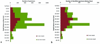
FIGURE 6. The number of recovered faunal specimens by depth: (a) all specimens, (b) specimens identified below class.
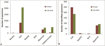
FIGURE 7. Recovery by class: (a) all specimens; (b) below-class identifications.
Other researchers have found that mesh size affects diversity and richness (e.g., Allen Reference Allen2014; Nagaoka Reference Nagaoka1994; Zohar and Belmaker Reference Zohar and Belmaker2005). A number of different indices have been used to quantify the number of taxa represented in a sample (richness) and the proportional distribution of taxa (evenness or equitability). When grouped at the level of family, there is one additional taxon in the 1.6 mm mesh fraction (Parulidae or New World warblers). Richness, when measured as simply the number of taxa (Lyman Reference Lyman2008) increases from 20 to 21. However, it is worth noting that when we are not constrained to comparison within the same taxonomic level, there are three additional taxa in the 1.6 mm fraction (Lepomis sp. or sunfish, Parulidae, and Microtus sp. or voles). It has been shown that the number of taxa in a sample will increase with sample size (e.g., Lyman Reference Lyman2008). A richness index (dl) can, to some extent, account for the differences in sample size (Banning Reference Banning2000). The value for the richness index dl is 4.0 for the 3 mm sample, and 4.3 for the combined sample, indicating that, despite the fact that the combined sample is larger, it is still richer. Equitability (V’) drops for the combined sample: the value is 0.80 for the 3 mm mesh fraction, while for the combined sample it is 0.78. This is possibly a reflection of the fact that many small-sized elements of common taxa such as perch (Percidae) were recovered from the 1.6 mm fraction, leading to a less even overall distribution (Figure 8).
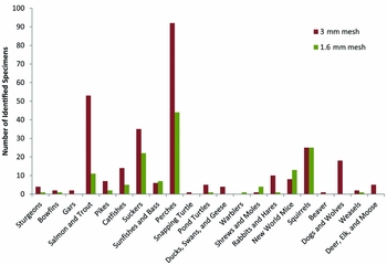
FIGURE 8. Distribution of identified specimens by family using two different mesh sizes.
While bones from some taxa are recovered only in the 3 mm fraction, notably dog and deer, most taxa have elements that are recovered in both fractions. One might argue that the exclusion of smaller-sized elements is unimportant because the taxa are usually represented by larger elements from the same species. However, where analysis includes consideration of taxonomic abundance, exclusion of small bones will differentially affect small-bodied taxa. From the perspective of comparative quantification, it is problematic to exclude smaller-sized elements by using large-meshed screen.
It is useful to consider which taxa are found only in the small-sized mesh fraction. Bones identified as Microtus sp., a member of the family Parulidae, and Lepomis sp. were recovered only in the 1.6 mm fraction. Members of the family Cricetidae were well represented in the sample—while it is unlikely that they played a significant part in the diet of the Huron-Wendat, the two common mice identified (Peromyscus sp. and Microtus sp.) have different habitat preferences (M'Closkey and Fieldwick Reference M'Closkey and Fieldwick1975), so the relative abundance of the two species within the assemblage could be important to reconstruction of past environments. Parulidae is the family of warblers. Only one other published reference to an identification of a warbler (an Ovenbird) in Ontario is known (Sadler and Savage Reference Sadler and Savage2003). Again, while unlikely to have been important in the diet, this may provide insights on technology for hunting birds (e.g., use of nets). Finally, the sunfish identifications are important because typically these are interpreted as warm-weather catches (Needs-Howarth Reference Needs-Howarth1999), and, if not identified, this would have biased interpretation of the sample toward spring and fall fisheries.
The elements identified in zooarchaeological samples can also serve as the basis for interpretations about location of processing. Fish assemblages that are dominated by cranial and branchial bones and underrepresentation of vertebral elements are thought to be the result of large-scale head removal and derive from a processing site. In contrast, fish assemblages high in vertebral and appendicular elements but low in cranial bones suggest a site of consumption. Comparison of the proportion of fish vertebrae to cranial elements from the two fractions shows that there are approximately two vertebrae for each identified cranial bone in the 3 mm fraction, but this increases to three and a half vertebrae per cranial bone in the 1.6 mm fraction with implications for reconstructing the location of fish processing. Measurement of the vertebral centra shows that the smallest vertebrae are lost (Figure 9). This will affect some species more than others: the vertebrae of small fish such as perch and sunfishes are likely to be missing from collections screened on larger mesh, leading to bias in any interpretation.

FIGURE 9. Height of complete vertebral centra from all fish taxa using two different mesh sizes
Archived Collections: The Chew Site (BeGx-9)
As descendant communities have become increasingly concerned with the destructive nature of archaeological excavation, the use of archived/existing collections is extremely important in the promotion of minimally invasive research strategies and sustainable archaeology (Ferris and Welch Reference Ferris, Welch, Atalay, Claus, McGuire and Welch2014; Sustainable Archaeology 2015).
In 1972, the Time Sweepers, members of a secondary-school archaeology club in Penetanguishene, carried out archaeological excavations at the Chew site on Tay Point. A total of 67 conti-guous 1.52 m2 units were dug as a trench transecting the site east to west. Twelve additional 1.52 m2 units were dug adjacent to the trench to explore locations of identified longhouses. Another four units were excavated in a midden south of the trench. Sieves (6 mm mesh) were used in the midden excav-ation, but not during the trench excavation. The archaeology club dissolved sometime around 1975 when legislation regulating archaeology in the province of Ontario was introduced. However, the artifacts from the Chew site excavations remained at the secondary school. In 1981, Jamie Hunter, then curator at Sainte-Marie among the Hurons (a seventeenth-century French Jesuit settlement among the Huron-Wendat and now a reconstructed historic site and museum), requested that the Chew site assemblage be moved to Ste. Marie's curatorial facilities, where it remains today. The collection is organized by artifact class—pottery, lithic, bone, European, and miscellaneous—and summarized in a catalogue. Unit provenience is recorded in ink on most artifacts.
The collection at Ste. Marie is the only known artifact collection from the Chew site and, despite being obtained during excavations that took place over 40 years ago, it remained unanalyzed. In May and June 2014, four senior undergraduate students from WLU examined and reported on the collection for course credit during the field school. A total of 4,277 artifacts were catalogued for the Chew site (BeGx-9). The majority of artifacts are pieces of Huron-Wendat ceramic vessels but also recorded are smoking pipes, lithics, and faunal remains. Approximately 2 percent of the artifacts are of European origin and include glazed ceramics, glass beads, gunflints, and copper, metal, and iron items, including a unique trade ring (Glencross et al. Reference Glencross, Warrick, Anderson, MacKinnon, Millar and Patterson2015). The collection contains artifacts that demonstrate consecutive Huron-Wendat village occupations of the site that date to the late fifteenth and early seventeenth centuries, as well as a European settler occupation during the second quarter of the nineteenth century (Glencross et al. Reference Glencross, Warrick, Anderson, MacKinnon, Millar and Patterson2015). The seventeenth-century Huron-Wendat village occupation dates to ca. A.D. 1620–1640 (based on glass bead chronology [Glencross et al. Reference Glencross, Warrick, Anderson, MacKinnon, Millar and Patterson2015]), overlapping with the historically recorded occupation of Quieunonanscaran from 1623 to 1637 (Heidenreich Reference Heidenreich1971:34–35). The proximity of the Chew site to Ahatsistari and the later date suggest that the Chew site represents a relocation of the Ahatsistari village.
THE VALUE AND FUTURE OF MINIMALLY INVASIVE STRATEGIES IN SUSTAINABLE ARCHAEOLOGY
Sustainable archaeology is informed by descendant-community cultural values and sensibilities, which, for many Indigenous groups, involve restrictions on the disturbance and excavation of ancestral sites. This approach signals a shift in standard archaeological practice in Ontario that is more responsive to Indigenous concerns about the extractive nature of archaeology. Indigenous interests are directly addressed through close collaboration, excavation of smaller areas, and deliberate recovery of the smallest artifacts and ecofacts and their intensive analysis to extract more information. Further, the analysis of existing archived collections, whether limited or imperfect, is important in effecting change in relations with descendant communities who often question the necessity of keeping collections that have not been analyzed. Sustainable archaeology is also informed by descendant-community traditional knowledge and ways of knowing. A less invasive approach that makes close collaboration possible also acts to enhance the flow and exchange of knowledge between archaeologists and descendants. The convergence between traditional and archaeological knowledge strengthens interpretations and understanding of the past in new substantive ways for both descendant and archaeological communities.
The importance of applying minimally destructive assessment and investigation methods to archaeology lies in their ability to conserve archaeological sites in situ. This is particularly significant when considering the relatively large number of archaeological sites damaged or consumed by land development and looting. Limited excavation and intensive recovery techniques also work to minimize the size of artifact collections from sites. The continuous accumulation of artifacts and the ability to manage, store, and make them accessible to all those with a vested interest are problems that many archaeologists and institutions are currently struggling with (Sustainable Archaeology 2015). That this minimally invasive strategy was applied during a field school has considerable effect on training the next generation of archaeologists and in advancing a sustainable form of archaeological practice.
Our minimally invasive strategy and testing of intensive recovery methods at Ahatsistari, while site specific, are adding to a growing body of knowledge regarding the effectiveness of these techniques in Huron-Wendat archaeology. We recognize that the multiple minimally invasive methods used in this project may not be appropriate for all projects, and that some investigators may even be reluctant to employ some of these methods (e.g., metal detecting because of the common association with artifact hunting in North America). We would also like to qualify our discussion of geophysical survey as minimally invasive by noting that, while useful in determining the areal extent or internal structure of sites, ground truthing is critical for verifying anomalies as cultural features, which makes some degree of excavation necessary. In addition, artifacts and ecofacts recovered during sampling based on geophysical survey will likely never approach the number of artifacts and, more importantly, the knowledge generated from full excavation.
The magnetic susceptibility results from Ahatsistari highlight problems encountered when conducting geophysical surveys in Canada. The magnetic signatures at Ahatsistari are difficult to read, as would be expected for many parts of Canada, where underlying igneous geology exists. In this instance, the chance of successful geophysical survey using only magnetic instruments is diminished. As with many aspects of archaeology, in order to maximize geophysical survey results, multiple techniques should be employed together (Jones Reference Jones2008). The results of our metal detector survey indicate that metal detecting may offer a suitable alternative for the identification of the extent and the internal structure of sites in regions unsuitable for magnetic susceptibility survey, at least in the case of historic sites.
The intensive recovery techniques (i.e., 100 percent recovery and wet sieving) are particularly important given a reduction in areal excavations and the need to gather substantial representative samples of artifacts and ecofacts. Work at Tay Point and in other archaeological investigations (Ball and Bobrowsky Reference Ball and Bobrowsky1987; Keeley Reference Keeley1978) has demonstrated an inverse relationship in which the number of smaller finds and taxa represented increases as a function of a decrease in sieve size. The use of 3 mm and 1.6 mm mesh at Ahatsistari shows unequivocally that 6 mm mesh is inappropriately large for screening of midden deposits on Huron-Wendat sites. Finally, the evidential and educational value of the Chew site collection is high, with implications for understanding the historical geography of Huronia, and Huron-Wendat interactions with other Indigenous communities and the French, while our work with Wilfrid Laurier University undergraduate students is important for instilling an understanding of the application of minimally invasive strategies in sustainable archaeology. Given the increasing pressure for noninvasive techniques and the lack of other suitable alternatives to shovel test pitting on wooded sites, we believe that there is a strong argument for the use of minimally invasive strategies framed within sustainable archaeology practice.
Acknowledgments
We would like to express our gratitude to the Huron-Wendat Nation for permission to conduct fieldwork, particularly Louis Lesage, Simon Picard, and Melanie Vincent, who helped facilitate the field school. We would also like to thank Graeme Davis, Senior Forester, County of Simcoe, who kindly provided permission to conduct work on the property, and Karin Taylor, Curator, for providing access to materials housed at Sainte-Marie among the Hurons. We would like to thank John and Marg Raynor, who generously provided space and water to conduct water-screening and hosted members of the Huronia Chapter of the Ontario Archaeological Society who assisted with water-screening. Finally, we are grateful to the four anonymous reviewers and the editor, who provided helpful comments that have improved the manuscript. Permission for fieldwork was granted by the Ministry of Tourism, Culture and Sport, Government of Ontario under licence P-377-0001-2014 (Bonnie Glencross, licensee).
Data Availability Statement
Survey and excavation records from the 2014 Wilfrid Laurier University field school at Ahatsistari (BeGx-76) are contained in the licence report on file at the Ontario Ministry of Tourism, Culture and Sport, Archaeology Program Unit, Hearst Block, 9th Floor 900 Bay Street, Toronto, ON M7A 2E1, telephone: 1-416-212-8886, e-mail: Archaeology@ontario.ca.


