
Introduction: What Happened at the End of the Early Bronze Age?
The fundamental instability of urban or urbanizing forms of settlement in the first half of the third millennium BCE, described in Chapter 3, set the stage for an extended period of regional, non-urban settlement trajectories that covers the entire second half of the third millennium BCE. This long process of urban retreat, which began as early as the first quarter of the third millennium in some regions, may no longer qualify for the sobriquet of collapse, but is nonetheless post-urban. That is, rather than representing a survival of a resilient, primeval village substratum to which urban society reverts at the end of EB III (as proposed by some of those who refuse urban status to any Levantine sites), it should be viewed as a response to the stresses and excesses of the urbanizing trends that had affected large parts of the Levant, and as a risk-minimizing strategy that expanded the resource base for a more dispersed population. A measure of the degree to which IBA settlement recognized previous centers is the peculiar choreography of settlement and burial near and within previously urban sites that will be detailed below. These testify to a persistence of memory and to the existence of a carefully constructed genealogy that underlies territorial claims and affinities of the inhabitants of the non-urban settlements. Similarly, persistent elements of material culture and technological style point to strong links between the urban and post-urban populations in most parts of the Levant.
The prolonged urban exodus of EB III should therefore be understood as a redeployment that opened new avenues of opportunity while breaking down the cultural barriers that characterized the ossified landscape of fortified towns. As will be seen, these new opportunities did not lead to the reemergence of centralized polities or to aggregations of wealth. Rather, for the next four centuries, the southern Levant appears to have settled into a “comfort zone,” from which it would be jolted only at the start of the second millennium BCE – a small-scale, politically segmented, territorially flexible village society.
Not to be overlooked is a sea-change in the direction and intensity of Levantine interaction with the broader region. The EB III southern Levant had grown increasingly insular, with only sporadic contacts with regions to its north and south. Egyptian connections had largely been severed, as Egypt cultivated the sea routes to Byblos and the north Levantine coast, while contact with Syria was limited to some down-the-line exchange of knickknacks such as ornamental cosmetic containers, detached from any assemblage that might be associated with them. This all changed in the IBA, when the Levant was drawn into the orbit of the “second urban revolution” in Syria. While this reorientation affected the entire ambit of Levantine culture, it is clearly graded: areas nearer to urbanized western Syria show the greatest impact, while areas to the south reflect the attrition of distance and the effects of transmission, reinterpretation, and reintegration of Syrian concepts into south Levantine practice.
The mid-third-millennium transformation of northern Syria, from the coast to the Jezireh, has been characterized as “the full-fledged adoption of urban life and its associated institutions,”1 comprising multitiered settlement hierarchies, monumental architecture, lavish funerary displays of elite status and the emergence bureaucratic state apparatuses. Western Syria, as far as the Euphrates Valley and even beyond it, was dominated by the Kingdom of Ebla in the Early Bronze IVA (c. 2500–2300 BCE). In the EB IVB (c. 2300–2100), after the Akkadian intervention and the destruction of Palace G at Ebla, the resurgent city at Ebla was one of several western Syrian urban centers that expanded their reach, founding settlements – or integrating pastoral groups who then founded new settlements – in the environmentally marginal areas along the edge of the steppes.2 One of the pillars of the western Syrian urban-pastoral economy was the production of and trade in textiles. The Fragile Crescent Project conducted in Syria describes, in detail, the ramifications of the spread of an intensive wool economy in the Levant in the second half of the third millennium: the replacement of linen by wool freed considerable tracts of arable land for staple agriculture, whereas the production of fibers moved to the marginal zones, better suited for sheep husbandry.3 As we shall see, the transformation of the Syrian economy in the mid-third millennium impacted the southern Levant in multiple ways, some more subtle than others.
Notes on Terminology and Chronology
As the original black sheep of tell-based narratives of cultural evolution, the IBA and the terms used to describe it have always served as a sensitive gauge of interpretive trends in Levantine archaeology.4 When Nelson Glueck’s surveys in Transjordan and the Negev began to call attention to the numerous desert sites of the “Middle Bronze I” that had so long eluded stratified excavations, W.F. Albright, in an article titled “Abram the Hebrew,” which was still required reading when I began my studies in the late 1970s, argued passionately for the attribution of those sites to donkey caravaneers of the early second millennium who would have plied the international routes between Middle Kingdom Egypt and Ur III and Old Assyrian Mesopotamia, and who were the prototype for the biblical patriarchs.5 Material-culture historians such as G.E. Wright, K. Kenyon, R. Amiran and M. Kochavi, struck by ceramic changes effected at the end of the EB III and visualizing them as the product of migration and invasion, sought out terms that would express the transitional nature of the ensuing period: “EB IV–MB I,” “Intermediate EB–MB,” and “Intermediate Bronze Age.” Olga Tufnell, who also favored invasion as the prime mover in cultural change, linked the “Intermediate EB–MB” to the European “Beaker Folk” and to Egypt’s First Intermediate Period, while coining the term “Caliciform Culture” for the period in question.6 The processual reaction to cultural–historical archaeology, embraced by local and anglophone researchers of the 1970s and 1980s in the Levant, included a healthy measure of indigenism; insisting that change was internally or systemically motivated unless proven otherwise, many archaeologists adopted the term “EB IV.”7 This term, while stressing continuity with the preceding period, has the added advantage of matching the terminology used in Syrian and Lebanese archaeology. Most recently, in an effort to create positivistic “neutral” definitions of the chronological divisions throughout Near East, the ARCANE project put forward the term Early South Levantine (ESL) 6, to cover the time period in question.8
The term “Intermediate Bronze Age,” as used here, subsumes earlier terminologies, which all refer to the same set of archaeological phenomena. It seems to be justified by the sheer length of the period – 400–600 years, depending on the subregion – and by the absence – for the most part – of the urbanizing elements that characterize the preceding Early Bronze Age and succeeding Middle Bronze Age. Where the term “EB IV” has become embedded in publications, for example, along the Lebanese coast and in Jordan, the excavators’ terminology will be used or noted.
In terms of absolute chronology, the transitions at either end of the period and between its internal stages are ill-defined. This is due to the absence of modeled radiocarbon sequences running from EB III to the IB, on the one hand, and from the IB to the MB I, on the other. The absence of such sequences is a product of the shifts in settlement patterns that characterize the beginning and end of the period, as well as the tendency of IBA settlements to relocate every few decades, which results in a wealth of sites and cemeteries spread across the landscape rather than superimposed on one another. A single modeled radiocarbon sequence from Tell Abu an-Niaj in the Jordan Valley – a region in which stratified IBA sites are most common – reportedly spans the entire second half of the third millennium.9 Combined radiocarbon and optically stimulated luminescence (OSL) measurements in the Negev Highlands suggest an occupation in the earlier part of the IBA.10 These results are consistent with a less clearly resolved sequence for the stratified site of Tell Arqa in Lebanon, one of the few Levantine sites with an EB–IB–MB sequence that shows only brief gaps, and with the new radiocarbon schemes for the third and second millennium Levant.11
Comparative ceramic studies have recently suggested a correlation between well-defined Levantine industries, such as the black wheelmade ware of the northern Jordan Valley and Biqa‘, and Syrian EB IVB, which might be limited to the period between 2300 and 2100 BCE.12 Jordan Valley IBA assemblages with strong EBA affinities, such as Bet Yerah Period E and Sha‘ar Hagolan, lack black wheelmade ware, and might represent an earlier ceramic phase, between 2500 and 2300.13 A similarly early date has been suggested for red-slipped ceramics of Transjordan and the Negev Highlands, and might receive support from twenty-sixth-century radiocarbon dates from the latter region.14 These will be discussed further below. Marta D’Andrea has collated a very broad selection of ceramics from the few stratified and radiocarbon-dated sites as well as from many single-occupation sites in an attempt to portray “early EB IV” versus “late EB IV” assemblages. The “early” phase is characterized by a technological regression in relation to the EB III, while the “late” phase provides more substantial regional industries that regain the use of slow-wheel coiling and adopt forms from the Syrian EB IVB sphere. As can be appreciated from her own use of scare quotes in these designations, the absolute chronological correlates of these technological observations are still uncertain.
The extension of the IBA over the entire second half of the third millennium might prompt the response that settlement and material culture assemblages are too thin on the ground to account for so long a period of time. In view of the downgrading of the intensity of urban EB proposed in Chapter 3 (and repeated in Chapter 5, for the MBA), a sparse population should be considered the norm over most of the Bronze Age Levant, the IBA being no exception. That said, discoveries of IBA village sites over recent decades, noted below, are gradually populating areas long thought to have been devoid of permanent settlement.
Climate
Of all the periods covered in this volume, there appears to be the greatest degree of agreement over the occurrence of significant climate events in the period between, roughly, 2200 and 1900 BCE, that is, in the second half of the IBA. Multiple lines of proxy evidence (extracted from ice cores, lake bottoms, and cave speleothems across the northern hemisphere) converge in indicating a significant and prolonged drought, caused by anomalies in the North Atlantic Oscillation, which is responsible for the Mediterranean westerlies that deliver precipitation in areas directly relevant to the Levant.15 But that is where agreement ends, since there has emerged a considerable body of debate over the impact of this event on microregions within the Levant, and over the nature of human response to it. The IBA is a case in point: clearly, the initial impetus toward the abandonment of towns, in the first half of the third millennium, can hardly be related to droughts at the end of the millennium. Moreover, the IBA preference for marginal-zone settlement is maintained from start to end of the period (though it is perhaps more pronounced in the earlier centuries) and would appear to be counterintuitive for a dry period, as would the retreat from these zones in the presumably somewhat improved second millennium climate. Nonetheless, there is a significance to the relative degradation of the agricultural potential of the Levant as a whole in the last quarter of the third millennium and perhaps a century beyond. This is the background against which the decisions taken by communities and individuals should be judged.16
Regions of Settlement
By c. 2400 BCE, all sites in the Levant that had shown an EB III presence were abandoned, some indefinitely, others only briefly. The fact that even sites with an ideal location and a long settlement history before and after the IBA experienced at least a temporary abandonment in the EBA–IBA transition suggests that it was marked by a significant conceptual rift, which required a fundamental restructuring of society, settlement and production. In Chapter 3 it was suggested that this restructuring was not a dramatic collapse, but a drawn-out transformation. Archaeologically, it is expressed in a series of global changes:
Settlement gaps at mounds, which were abandoned either for a brief spell at the start of the IBA, for the entire duration of the IBA or permanently (or at least for many centuries, until their previous nature had been long forgotten)
Resettlement of sparsely settled zones at the margins of EB III settlement, such as the coastal strip and the semi-arid margins in the Negev, eastern Samaria and the Transjordanian plateau
Village settlement on slopes adjacent to wadi beds and alluvial valleys. Especially in the Jordan Valley, such village sites could be long-lived, creating minor tell sites of their own.
A resurgent mortuary landscape, characterized by extensive shaft-tomb cemeteries, sometimes unassociated with comparable settlement remains. Interments are often individual and exhibit expressions of status, reflecting a break with the previous collective ethos.
Regional ceramic styles associated with village workshops, new ceramic repertoires and the much-increased circulation of metals and metal artifacts; these signify new relations of production and new modes of social interaction.
The fissioning of large settlements at the EBA–IBA transition and the establishment or enlargement of nearby cemeteries is representative of the larger settlement picture. The IBA is characterized by an abundance of sites and of cemeteries (both below and above ground). Few settlement sites are stratified, so that their abundance can generally be taken to represent the pattern created by semi- or partially sedentary groups, moving through the landscape over the five centuries of the IBA (Figure 4.1).

Figure 4.1 Map of sites mentioned in this chapter.
Lebanon, Galilee and Hauran. Genz distinguishes between south Lebanon and the Biqa‘, where IBA remains are known primarily from tombs, and the north Lebanese coast, where urban settlement continued at some sites (principally Byblos and Arqa).17 Settlement remains were recorded at Tyre on the coast and at Baalbek in the valley, while Marfoe notes IBA pottery collected at sixteen sites in the Biqa‘, all of them previously occupied mounds, and a chamber tomb at Rafid in the southeastern Biqa‘.18 In highland Galilee, five sites – most of them previously occupied – show some evidence of occupation, alongside nine tombs, most of them not clearly related to settlements.19 In the Hauran, settlement declined (e.g., at Labwe) with some pastoral continuity at edges of previous towns and a marked pastoralist presence at Kh. Umbashi.20
Upper and Central Jordan Valley. In a pattern that appears typical of valley settlement, the seven identified settlement sites in the Hula Valley were all established on mounds or previously settled sites. Apart from Tel Hazor and Tel Dan, where ephemeral IBA settlement succeeded urban EB III occupation, the other sites had all been abandoned since the late EB I or EB II. A shaft-tomb cemetery adjacent to Hazor and dolmen fields ringing the valley have been attributed to the IBA as well. Bechar has suggested that the IBA settlement represented in the Hula Valley sites should be dated to the second half of the period.21
Surveys conducted in the Jezreel and Bet Shean Valleys all note a sharp increase in the number of sites from EB III – counting as many as one hundred find-spots, including upward of twenty cemeteries.22 It is clear that a good number of these occurrences – many of them on mounded, multiperiod sites – mark ephemeral settlement, but there is ample evidence for sustained village settlement as well, particularly in previously unoccupied or long-abandoned sites, such as ‘Ein el-Hilu, Nahal Rimmonim and Murhan. Tell sites, including Megiddo and Bet Shean, show ephemeral occupation on the mounds, off-mound settlement and large cemeteries. On the eastern side of the valley, settlement is clustered in the central sector, north of Wadi Zerqa, with a large and long-lived village site at Tell Um Hammad and smaller, stratified sites excavated at Tell Abu an-Niaj and Tell el-Hayyat. Large, partly excavated cemeteries are reported at Wadi al-Hammah and Tiwal ash-Sharqi.23
Highlands and Coastal Plain. In the central hills, 285 find-spots of the IBA are recorded in the West Bank archaeological database;24 of these, about a third are cemetery and cave sites, and many more are ephemeral or uncertain identifications. Finkelstein noted forty-nine settlement sites, to which more recent surveys may have added a few.25 He noted a pattern that still appears to hold true, of a greater proportion of settlements in the northern part of the hill country, and of cemeteries in the southern part. The proliferation of small sites and cemeteries in the south might be causally related to the earlier, late EB III, growth of settlement in the adjacent plains. Similarly, Palumbo notes more than 250 find-spots east of the Jordan, of which 29 are cemeteries and only 20 are positively identified as settlements, largely conforming to EB III regional patterns.26 A more detailed review of settlement on the Kerak plateau seems to confirm the EB III–IBA continuity and the likelihood of a considerable number of settled sites, while highlighting the considerable confusion caused by imprecise survey period attributions.27 Sixteen sites and seventeen cemeteries have been counted along the coastal plain, many of them in littoral areas that had not been settled in the EB II or III, with several more sites and tombs surfacing due to salvage work along the eastern fringes of the coastal plain in recent years.28
Negev and Sinai. Upward of 300 IBA sites and tumulus fields have been surveyed and excavated in the Negev Highlands, and a total of perhaps 500 in the Negev and the Arabah Valley. A similar number of sites is recorded in the northern and central Sinai.29 Here too, most sites, by far, are tiny and short-lived, and only a handful are characterized as “permanent.” There is disagreement whether some of the sites attributed to the IBA might have been settled earlier, in EB III, but there is no question that the IBA represents the high-water mark of Bronze Age arid zone settlement.
The prodigious number of IBA “sites” cited in the preceding paragraphs – approaching a total of 2,000 in all parts of the Levant and Sinai – requires explanation and qualification. One aspect to be considered is the visibility of IBA ceramics, which results in their easy identification even as individual occurrences. While in previous and some subsequent periods ceramic production and consumption was concentrated in urban workshops and domestic quarters, the democratic character of IBA ceramic production meant that everyone had access to the typical workshop products. Thus, in a period like EB III, where diagnostics are closely linked to particular workshops – whether the giant platters and pithoi of urban centers or the specialized Khirbet Kerak ware that was largely limited to a small number of communities – non-urban pottery production, if it existed, has never been described and remains buried in the “non-diagnostic” fraction of survey collections. In the IBA, typical techniques, decorations and clays are spread across the entire Levantine landscape. Another aspect to be considered is the sheer length of the period and the transitory character of many settlements, which creates an abundance of sites. That is, single communities may responsible for several sites over time, including both year-round and seasonal occupations. Because of the sedentary, tell-oriented bias of Bronze Age archaeology in the Levant, the dynamics of IBA settlement remain largely in the realm of surmise, founded on survey and salvage work and chance finds, rather than a focused research strategy. This has only lately begun to change, and preliminary results of new studies will be incorporated below, in the detailed description of the period.
Settlement Dynamics: The Abandonment of (Most) Tells
As we saw in Chapter 3, each of the fortified towns of the EB III took its own path to abandonment: some were abandoned early, and others late; some appear to have devoted enormous energies to augmenting their fortifications, right to the bitter end, while others dispensed with fortifications and seem to have established themselves as centralized manorial estates. Thus, though all these towns or strongholds were deserted by 2400 BCE, several typical trajectories to the creation of the post-urban landscape can be described.
At Tel Bet Yerah, in the Jordan Valley, Greenberg and Eisenberg describe a “terminal” EBA settlement that appears to catch the process of collapse in flagrante: the floors of a warren of multiroom, late EBA houses, built in proximity to the latest fortifications there, yielded pottery of crude local manufacture that clearly postdated the classic EB III industries, yet lacked the characteristics of standard IBA pottery, known from many nearby sites.30 Soon afterward, two slab-lined tombs were built just south of the mound, in Kibbutz Deganya A;31 they contain ceramics and metal finds that must slightly postdate the “terminal EBA” settlement on the mound, illustrating a common IBA theme of using the abandoned mound as a mortuary marker and perhaps staking a territorial claim for the lands of the former urban settlement. Only a few kilometers south of Bet Yerah, at the far end of the same Kinrot valley that sustained the former town, the large IBA village of Sha‘ar Hagolan was established, virtually reproducing the layout of the “terminal EBA” quarter at Bet Yerah and exhibiting a rich assemblage of well-made IBA ceramics (see Figure 4.8).32 Tel Bet Yerah itself was never resettled in the IBA proper, and only sporadically in later periods.
A slightly different path was taken at Tel Lachish, which had a robust, though largely unexcavated, EB III settlement: here, the site was completely abandoned, with IBA occupation reemerging on a hill just northwest of the mound, within view of it.33 A shaft-tomb cemetery was established on the slope beneath the site. Similarly, the town of Tel Yarmuth was abandoned for the duration of the IBA (and beyond), with small IBA settlements and cemeteries established just out of sight of the mound, 1–2 kilometers to the northeast.34 This pattern appears to have been repeated at several other sites in the southern plains (e.g., Tell es-Sakan and the nearby IBA cemetery at Tell el-‘Ajjul).
At the great fortified center of ‘Ai, no IBA settlements were identified on the mound or in its vicinity, but the extensive cemeteries of ‘Ain Samiya/Dhahr Mirzbaneh, and the associated tumulus and platform that appear to have been mortuary cult installations, were established within 10–12 kilometers of it.35 This pattern is repeated in other hill sites, where IBA hamlets, tombs and cult sites offer a nuanced picture of hill-country settlement, suggesting an integration of agricultural and pastoral pursuits within the former urban territories.36
At Bab edh-Dhra‘, Jericho, Tel Bet Shean and Megiddo, there is evidence – usually ephemeral – of IBA reoccupation after a period of abandonment. At Bab edh-Dhra‘ and Jericho, a few houses were built on the perimeter or just outside the erstwhile town,37 while at Megiddo and Bet Shean there is some activity on the mound proper; at Bab edh-Dhra‘ and Megiddo there is evidence for small-scale cultic activity as well. Each of these sites has a substantial cemetery that must have served more than just the temporary occupants of the mound. Tel Hazor and Tel Dan also show limited reoccupation, although the cemeteries associated with these sites are either not identified (Dan) or not excavated (Hazor).38
In all the cases described above, the former occupants of the EBA towns were dispersed, creating a new, site-abundant settlement pattern that carefully avoided the reinstatement of the fortified place as a dominant presence (Figure 4.2). Yet, in each case, the erstwhile towns were not forgotten and often continued to serve as a commemorative or territorial resource: small settlements were established within a 2-kilometer radius of the mound and earlier cemeteries were reused, or, as was often the case, new cemeteries were established within view, where there had been no EBA cemeteries before. At Bab edh-Dhra‘ and Megiddo, cultic structures were maintained at the edge of the mound or in the previous cultic area. In those cases where settlement was renewed, it either took the form of a squat within the old EBA buildings (e.g., at Dan and Hazor) or carefully skirted earlier ruins (as at Jericho). A. Mazar sees this as intentional avoidance of places associated with recent disasters. S. Paz expands on the theme, suggesting that the tells were part of a redrawing of the IBA cognitive landscape, specifically intended to marginalize the former fortified centers and reject the values embodied by them.39 The almost universal presence of shaft-tomb cemeteries adjacent to these sites, however, does point to a still-viable territorial claim. Whether as direct, biological descendants of the previous inhabitants, as non-urban kinsfolk, or as new arrivals inventing a historically sanctioned connection to the land, IBA people were not oblivious to the ruins of earlier towns but incorporated them in their landscape.

Figure 4.2 Tell-avoidance in the IBA: (a) the location of settlements in relation to Tel Yarmuth (courtesy of S. Paz), (b) Tell ed-Duweir/Lachish and (c) the walled precinct of EBA Bab edh-Dhra‘, with IBA find-spots circled. Redrawn after Tufnell Reference Tufnell1958: pl. 89, and Rast and Schaub Reference Rast and Schaub2003: fig. 1.4.
If tell-avoidance was a common and significant trope in the cognitive landscape of the IBA, it was not universal. A few tell sites, in different parts of the countryside, were substantially resettled in the IBA. These fall into two groups: north Lebanese coastal sites like Tell Arqa and Byblos, where the settlement hiatus must have been very brief, and where IBA (or, more properly for this region, EB IV) settlement shows no decline with respect to the earlier period, and a few south Levantine sites that buck the typical IBA trend and fully reoccupy earlier mounds.
At Tell Arqa, part of a densely built residential quarter was excavated (Figure 4.3), spanning the entire second half of the third millennium BCE (Strata 16–15, Period P).40 Houses, built along a peripheral street, were two stories high, with the lower floor given over – by the end of Stratum 16 – entirely to storage of great quantities of grain in a series of narrow cells and the upper floors used as living quarters. A great conflagration at about 2200 BCE allowed the preservation of the charred grain and massive quantities of carbonized timber used in the construction of the house interiors. The site was not fortified, but protected by the continuous exterior wall of a row of rooms built around the perimeter of the site. The pottery is described as very much a local repertoire, different from that of the preceding phase, characterized by “a coherent set of liquid-related or drinking vessels, including a variety of jugs and large numbers of conical beakers and one-handled cups.”41 The flint and metal finds, however, evince a strong connection to inland Syria.
Figure 4.3 EB IV houses at Tell Arqa.
Byblos underwent a significant destruction in the latter part of the third millennium, bringing to an end the urban EB III settlement there (Stratum K IV, according to Saghieh’s scheme). It was immediately rebuilt, preserving its cultic core while apparently losing some of its urban density.42 Whether this transition is coeval with the EBA–IBA transition in the southern Levant is uncertain, although the presence of Fifth Dynasty objects in K IV might indicate a late twenty-fourth-century date for the end of the EB III at Byblos. Genz notes the presence of inscribed Sixth Dynasty objects, perhaps in the earlier IBA (EB IV) stratum at the site, as well as evidence for mutual contact with the Mesopotamian Ur III dynasty, at the very end of the millennium.43 Like Arqa, Byblos appears to have developed its own ceramic tradition in the late third millennium, showing some generic similarities to neighboring regions but evincing little interaction with the village industries of the inland and southern Levant.
In the southern Levant, Tel Na‘ama in the Hula Valley had been abandoned since the end of the EB II when it was resettled in the IBA.44 Some 2 meters of accumulation suggest a substantial and long-lived settlement on the 4-hectare mound. Tell Um Hammad, a large EB I site in the southern Jordan Valley that was reduced to a modest village in EB II, was resettled extensively in the IBA, moving (expanding?) from the eastern to the western hill.45 The resettlement was accompanied by the establishment of several cemeteries. Kh. Iskandar, on the Wadi Wala in southern Jordan, was a fortified EB III town. Uniquely among sites of this type, it was extensively reoccupied in the IBA after what appears to be a brief hiatus and its fortifications may have remained in use.46 All these southern Levant settlements, however, can be accommodated within the pattern of IBA village settlement, which will be our next concern.
The IBA Village and Its Material Culture
Intermediate Bronze Age villages are typically composed of sprawling house agglomerations, not unlike those found in EBA towns and barrios. These agglomerations may be composed of as few as one and as many as five individual family units, separated from other units by courtyards, open space, or alleyways. The egalitarian nature of the village house units, their ability to expand and merge according to need, and the presence of communal space, where collective activities such as grain-processing or animal-corralling could be pursued, all point to a corporate form of village organization and collective ownership of land. We might also expect to see some overlap between the distribution of clustered villages and that of collective burials in tombs (see below), but it is difficult, at present, to show a systematic connection between known villages and excavated IBA cemeteries. A review of several representative excavated sites follows.
Sha‘ar Hagolan was one of several large settlements in the Jordan Valley.47 Parts of several house clusters have been excavated, apparently near the center of the village, but evidence for occupation extends over 20 hectares, and the excavator assumes that it was composed of several distinct clusters similar to the ones excavated. The central cluster, Area 100, included about twenty-five rooms and spaces that the excavator assigned to six separate houses of irregular plan (Figure 4.4). Most houses could be assigned a central broad room and auxiliary spaces. Area 200, nearer the edge of the settlement, included three main units with associated courtyards and open space between them. Based on the ceramic, ground stone and chipped stone finds, food processing, preparation, storage and consumption were carried out in each household unit. Canaanean sickle blades attest to the perseverance of this local industry in the IBA, but the apparent absence of tabular scrapers, which was a regular ingredient of earlier third-millennium assemblages, might indicate a breakdown of one of the small-scale interregional EBA networks of production and trade.48 The rich pottery assemblage, composed primarily of storage jars, cooking pots and open bowls reminiscent of the late EBA (see below, Figure 4.7), but with an added ingredient of pouring and drinking vessels, all appears to be of local manufacture, with the possible exception of a bag-shaped jar with applied rope decoration, which seems to have been produced in the Bet Shean region.49 The relation between the local ceramic industries will be explored in greater detail below.

Figure 4.4 Block-plans of Shaar Hagolan and Tell Um Hammad in the IBA, and an independent, modular house unit, with its ceramic assemblage, in Nahal Refa’im.
Sha‘ar Hagolan can be compared with two extensively excavated sites in adjacent regions: the large settlement at Tell Um Hammad in the middle Jordan Valley and the diminutive hamlet of ‘Ein el-Hilu in the northern foothills bordering the Jezreel Valley.
The eastern mound of Tell Um Hammad, on the alluvial fan of Wadi Zerqa, was occupied from Chalcolithic times until the early EB II, and then abandoned for most of the first half of the third millennium.50 It was reoccupied in EB IV, expanding or migrating from the eastern to the western mound – a distance of 600 meters – as the period wore on. The larger western mound, about 3 hectares in size, was the more densely settled of the two, with the latest construction phases characterized by a well-ordered layout of clustered rectangular compounds separated by paved alleyways (Figure 4.4). As in the case of other eastern Jordan Valley sites – Tell Abu an-Niaj, an agrarian village with a long sequence of occupation, and Tell Iktanu, a stratified site with rectangular house-clusters and potter’s kilns51 – detailed descriptions of the excavated households have yet to be published.
Tell Um Hammad is linked to an enormous cemetery, Tiwal ash-Sharqi, that lies to the southwest of the site, composed primarily of shaft tombs with individual burials. Differences in tomb size and quantity of burial deposits (primarily pottery) indicate subtle status differences, which cannot be directly translated into simple categories of “wealth.” Like Sha‘ar Hagolan, the site and cemetery reveal a ceramic tradition that is in tune with the broader region but which has its own local idiosyncrasies that testify to village workshop production.52
Excavations at ‘Ein el-Hilu, on the northwestern margins of the Jezreel Valley, have revealed the greater part of this small village site.53 Parts of six house compounds were discovered with a large part of their inventory intact (the discovery of intact vessels at many IBA settlements seems to point to organized migration from these sites, since almost any other form of abandonment would have been accompanied by extensive scavenging). The houses have a sprawling modular layout resembling the houses of Sha‘ar Hagolan, but they are not tightly clustered. Spaces between the houses and at either end of the village were used for agricultural processing, most likely by several households together. In three houses, small cult corners were identified, marked by a standing stone or pillar. The ceramic inventory at ‘Ein el-Hilu greatly resembles that of Sha‘ar Hagolan and Um Hammad in functionality and in broad stylistic terms, but has the local variations that can be observed at virtually every IBA site. Significantly, there are clear ceramic imports, mainly from the north and central Jordan Valley, but also from the northern Levant. The chipped stone and ground-stone assemblage points to agricultural processing, while several clay spindle whorls suggest some textile manufacture. The mammal assemblage points to small-scale sheep/cattle husbandry focused on traction or secondary products (milk, wool), as well as limited pig-raising for meat. The presence of imported ceramics as well as Canaanean sickle blades points to the participation of this small hamlet in a greater regional exchange network. ‘Ein el-Hilu might, therefore, have been a seasonal offshoot of a larger central site, or its inhabitants might have participated in periodic regional gatherings that allowed them to maintain relations with their own clans or with others. A single tomb found about 300 meters south of the site has been associated with it, but there are large, possibly regional burial grounds within a radius of a few kilometers from the site, for example, at Maz‘arib or even Hazorea‘ and Megiddo.54
Salvage excavations at other sites in the Jezreel Valley, for example, at ‘Afula in the central valley and at Murhan in the east, uncovered parts of domestic house units closely resembling those of ‘Ein el-Hilu.55 Horbat Qishron, too, on the northeast margins of the valley, yielded an architectural and material-culture assemblage that is virtually interchangeable with the valley sites.56
Intermediate Bronze Age village sites in the central hills have been excavated recently in the Bet Shemesh foothills, and on the Mount of Olives near Jerusalem, but the most extensively excavated site, although not fully published, remains that of Nahal Refa’im, excavated by Emanuel Eisenberg in 1980s and 1990s.57 Spread over an area of several hectares on several natural terraces overlooking a major seasonal stream (see Chapter 5, Figure 5.21), the Nahal Refa’im village seems to be composed of a central cluster of about thirty rooms belonging to three or four clustered houses and several additional houses at intervals of 15–30 meters. Like other settlements, the houses at Nahal Refa’im are modular; that is, they seem to have an original core of a square or rectangular hall and two or three rooms, to which additional rooms, storage spaces, courtyards and fences were added according to need (Figure 4.4). At least three instances of domestic cult installations are reported, consisting of single or grouped standing stones. As at all other IBA villages, the household ceramic, stone and flint inventories are fully compatible with a sedentary, mixed farming subsistence base, although there appear to be relatively fewer bowls, in comparison with the north, and more pouring and drinking vessels – a preference repeated at several other sites in the southern hills and the Negev. Botanic remains included cereals, legumes, grapes and olives. The mammal assemblage shows a broad spectrum of species, including sheep and goat (81 percent), pig (15 percent ), cattle (3 percent ) and two equids (0.7 percent).58 The relative abundance of immature sheep/goat and the general properties of the site are more consistent with meat or milk exploitation than with wool production. Ceramic production was almost certainly local, since two mine shafts that followed a vein of dolomitic sand used in the local pottery were excavated just above the settlement. The shafts were dated by secondary IBA interments introduced into one of them after it went out of use. Additional caves within the site were used for individual burials, and a small shaft-tomb cemetery – also composed of individual burials – was excavated on a hilltop, a few hundred meters north of the site.
Kh. Iskandar, in the central Transjordanian plateau, on a strategic crossing point on the north bank of the Wadi Walla, is something of an outlier among the IBA settlements, as it represents a robust, stratified, town-like settlement sequence on the site of an earlier EBA fortified town. More than any other excavated IBA site, Kh. Iskandar offers a sense of continuity with EBA settlement characteristics, while sharing important commonalities with simpler IBA sites, such as a similar material culture assemblage and similar burial practices (both of which are markedly discontinuous with the EBA). Two main areas of excavation have been described in some detail: Area C, where parts of two multiroomed rectilinear compounds flank what has been described as a stepped and paved “gateway” (Figure 4.5), perhaps delimiting the northern half of the previous fortified enceinte as the area of concentrated IBA settlement, about 1 hectare in size;59 and Area B, where parts of a large, well-built domestic compound with pillared rooms overlies an earlier structure that contained a very large assemblage of complete ceramic vessels.60 The wealth of finds in both phases in Area B testifies not only to sedentary agricultural pursuits but to the accumulation of surplus staple goods and of social capital by some of the residents. An additional marker of social status is the relatively large size and periodic reuse of several burial chambers in the adjacent cemetery. But beyond the robust construction, the accumulation of staples and the large tombs, there is no other evidence for outstanding wealth at the site. Moreover, the petrographic study of its ceramics points to a limited range of regional contacts, when compared with, for example, the Negev sites (below).61

Deep in the Negev Highlands, Har Yeroham is the southernmost site to present the typical IBA village structure (Figure 4.6).62 One large compound and two smaller ones, covering about 0.3 hectare in all, were excavated. The main compound, in the eastern part of the site, contained about twenty rectilinear rooms, many of them with stone bases for roof supports, which seem to belong to two or three domestic units. Two occupation phases were recorded in some of the structures. Finds appeared to be consistent with agricultural pursuits (at least, seasonal ones), since they included a handful of sickle blades and grinding stones, alongside the usual ceramic inventory and a large component of flint pounders, typical of the Negev IBA. Remarkably, a ceramic workshop, including a kiln, abutted the main compound, attesting to local production of pottery even at such a small, isolated site. The western compound contained fewer structures, an area with cupmarks that may have been used for communal processing activities, and several burial cairns, which were considered contemporary with the latest phase of IBA settlement. A cache of copper ingots discovered at Har Yeroham connects this site with others in the Negev Highlands that appear to have been part of a regional network of copper extraction and distribution (below). This site therefore combines (coevally? in sequence?) elements of village organization typical of the Mediterranean agricultural zone with elements that tie it to the IBA metalworking complex and to the long-standing local “Timnian” complex.

A complementary settlement type to the typical IBA village is the dwelling cave, several of which were excavated at Jebel Qa‘aqir, at the margins of a large shaft-tomb cemetery complex.63 Dwelling caves were slightly modified natural caves, of a type that abounds in the chalk foothills of the central highlands, especially in the south. The caves at Jebel Qa‘aqir were up to three rooms deep; some appear to have been used as dwellings, others as refuse dumps. The rich material assemblage associated with the caves resembles that of the built villages, including a large component of storage jars, open bowls, cups and cooking vessels, as well as a few teapots, amphoriskoi and other types. Non-ceramic finds included Canaanean blades, grindstones, mortars, pounders, and a clay loom weight. A terracotta figurine of clear Syrian type is noteworthy. A kiln, found at an undisclosed distance from the caves and from some above-ground structural remains at the site, represents yet another case of on-site ceramic production, which must be considered a characteristic feature of IBA village settlement. W.G. Dever has long presented Jebel Qa‘aqir as a prototypical site of pastoral nomads who practiced north–south seasonal transhumance between winter pastures in the Negev Highlands and summer pastures in the southern Hebron hills.64 There is, however, no compelling reason to identify the Qa‘aqir cave-dwellers as nomadic. Rather, the caves should be understood as seasonal dwellings of villagers from the nearby region, some of whom may eventually have split off from the mother village to make a permanent home in the caves. This pattern of use is well known in the south Judean hills region in premodern times, and can be attested for several historical and archaeological periods.65
The preceding survey of IBA villages, most of them excavated or published in recent decades, offers a new and remarkably uniform portrait of IBA village life that can be characterized almost as the polar opposite of the EBA town: where the town constrained housing to nuclear family units, the loose village structure allowed modular expansion for extended families; where town walls advertised boundaries, villages merged into the countryside; where urban power was expressed through collective labor and monumental construction, village houses reflected the labor power of the nuclear or extended family alone, and no public construction was attempted. To the extent that status was manifested, it was in the growth of families and of their productive capacity, as reflected in houses with a greater number of rooms or greater storage capacity. Ritual was confined to the domestic sphere, including – as I shall try to demonstrate below – mortuary ritual; this is in sharp contrast to the collective ethos of the EBA as expressed in its temple complexes as well as in its collective cave tombs and charnel houses. The segmented political structure of villages was conducive to fissioning, that is, the sloughing-off of small groups who founded new settlements at a distance from the parent settlement. This probably occurred when villages grew and created pressure on the lands in their immediate environs. But despite the absence of any visible political hierarchy, IBA villages, as a type, show greater stability than any previous social arrangement in the Levant since the Late Chalcolithic. Indeed, the largest villages are usually those that show the greatest longevity.
I have noted, in several separate instances, the existence of small cult corners or stelae in IBA domestic contexts. There is, in addition to these, only one shrine or cultic installation that can be associated with the IBA village population (leaving aside the possible shrines at reoccupied tell sites): Tel ‘Ashir, on a kurkar hill in the central coastal plain, overlooking the sea.66 This isolated site consisted of a row of rounded drum-shaped stones, each paired with an upright slab – all of limestone – the whole surrounded by patches of ash, collapsed bricks, carbonized wood, ash and a few artifacts, including fragmentary ceramics, copper daggers and tools, and flint blades. It is not associated with any settlement remains.
Village Ceramic Production
Ceramic production was integral to village life in the IBA and was one of the modes of post-urban regeneration. In the EB III, ceramics had been purveyors of inequality: the great Houses of the EB III used massive pithoi to advertise their accumulation of staple wealth, and the massive platters to engage in conspicuous hospitality, while putting those who were being fed in irremediable debt. With the demise of towns, the attached ceramic industries were all extinguished; ceramic know-how, however, was certainly preserved, since it quickly resurfaced in the dispersed village industries of the IBA. Those industries maintained the technology of EBA ceramic production, while improving its technical quality and changing its decorative and formal priorities. One of the striking changes in the ceramic inventory was the adoption of a new set of containers designed for the mixing, distribution and consumption of beverages (Figure 4.7). These did not take the same form in every region – for example, distribution vessels could have a pinched rim (common in the northern Jordan Valley) or a separately formed spout (common in the south and coast), cups could be relatively deep or shallow – but the functions were nearly always reproduced. The shift from competitive feasting to convivial drinking implied by the change in the ceramic inventory has deep social implications that resonate with the other changes effected in the transition to IBA. But they also bear the imprint of cultural transmission, since a similar set was adopted broadly in western Syria in the mid-third millennium, and certain stylistic flourishes – as well as a complete repertoire of specialized vessels (the black wheelmade ware of the Biqa‘ and northern Jordan Valley) – can be shown to travel from north to south.67

Figure 4.7 The IBA drinking repertoire in several workshop traditions: (a) black wheelmade ware (after Tadmor Reference Tadmor1978: fig. 8), (b) northern Jordan Valley (after Eisenberg Reference Eisenberg1985: figs. 3, 4), (c) middle Jordan Valley (after Feig Reference Feig1991: figs. 5, 6) and (d) Judean hills/Negev Highlands (after Cohen Reference Cohen1999: figs. 145–147).
The rarity of stratified IBA sites and the long duration now accorded to the period seems to have induced a need among archaeologists to subdivide the period chronologically. Since radiocarbon dates are still thin on the ground, ceramic typology has been invoked to establish a bi- or tripartite division (e.g., EB IVA, B, C). But, as in the 400-year EB III, little consensus has been achieved. Putting aside chronology, for the moment, the rich ceramic record of the period does allow us to draw a map of interlocking regional ceramic traditions that represent a blend of pre-existing local styles, acquisitions from the Syrian ceramic tradition, and innovation.68
A graphic illustration of the process of ceramic regeneration can be seen in the Kinrot Valley, south of Lake Kinneret, where a “terminal EB” post-urban ceramic horizon identified at Tel Bet Yerah gives way to a specialized village industry represented in the abandonment assemblage of the sprawling IBA site of Sha‘ar Hagolan (Figure 4.8).69 The Period E assemblage at Bet Yerah was characterized by a limited repertoire of forms – two types of bowls (round- and straight-walled), one beaker, two types of cooking pots (holemouth and necked), two of jars (small and large) and four-spouted lamps. All were entirely handmade, with many closed vessels showing evidence of having been pressed into a mold. There was no slip or burnish, and the only decoration was a strip of rope-molding along the bowl rims or at the join between body and neck on large jars and incised lines on holemouth rims. Lost in transition were core EB III techniques (wheel finish, red slips, pattern burnish, painted designs) and forms (platters, combed jars and pithoi, jugs).

Figure 4.8 “Terminal EBA” pottery from Tel Bet Yerah, Period E (left), and IBA pottery from Sha‘ar Hagolan (right). After Greenberg and Eisenberg Reference Greenberg, Eisenberg, Greenberg, Eisenberg, Paz and Paz2006: figs. 5.96–5.99; Eisenberg Reference Eisenberg2012: figs. 41–47.
The assemblage recovered from the floors of the large village of Sha‘ar Hagolan, about 4 kilometers southeast of Bet Yerah, represents the final abandonment of the site, which may be assumed to have occurred several generations after that of Bet Yerah. Based on the same core types as the Bet Yerah group – two bowl types, beakers, holemouth and necked pots, jars and four-spouted lamps, the Sha‘ar Hagolan potter added a few minor types (particularly in the amphoriskos category) but, more pointedly, reestablished several EBA techniques – tournette formation, red slip and paint, combing – and added some new IBA flourishes – the folded “envelope” ledge handle; the wide, flat base; the sliced rim; and pie-crust decoration. The emphasis on pouring and drinking vessels was now marked, with strong parallels in EB IVA Syria.70
The Sha‘ar Hagolan assemblage is generally comparable to the comprehensive village assemblage from ‘Ein el-Hilu. However, the latter shows a broader range of types and, in addition to locally made wares, contains artifacts from distant ceramic workshops with well-established traditions – e.g., trickle-painted vessels from the Jordan Valley and isolated artifacts from the Lebanese Biqa‘ or beyond it. It may therefore be permissible to posit a gradual development in the IBA ceramic industries in the northern valley regions, beginning with the post-urban household manufacturing of Period E at Tel Bet Yerah, continuing with the emergence of specialized village workshops such as that of Sha‘ar Hagolan and ‘Ein el-Hilu, and culminating in the emergence of distinct regional styles. These would have enabled ceramics to acquire added significance in the context of reciprocal exchange, signaling their origin and possibly their biographies – who made, handled, owned and exchanged them – and hence their social value.
Still in the northern valleys, the typologically and technologically distinct black wheelmade ware (BWW) encapsulates the ceramic interface between the urban aspect of the Syrian Levant and the more southerly region. The BWW assemblage consists entirely of vessels used for the mixing, distribution and consumption of liquids: bottles and kraters, teapots and cups. The vessels were made of fine clay (well-levigated Lower Cretaceous clays of the type previously used for EBA Metallic wares) and turned on a slow wheel, allowing them to attain a high level of delicacy and symmetry. Their dark coloring was attained by reductive firing, and they were decorated with white bands, often scrabbled to reveal the dark surface beneath them. BWW was found in considerable quantities in upper Jordan Valley sites (particularly at Hazor), and in tombs in the Jezreel, Jordan and Biqa‘ Valleys. All their components can be shown to have Syrian antecedents, but the peculiar combination and technique make them a distinct regional type that straddles the interface between the urban and non-urban potting traditions.71 Other regional industries of the northern valleys include the trickle-painted vessels of the middle Jordan Valley (both east and west of the river) and the Upper Galilee/Hula Valley industry.72 Each of these, as well as numerous regional industries in areas farther to the southwest, shows its own set of peculiarities and preferences (painted decoration in the first group, pinched mouths and stippled decoration in the second, and so on), placed within a shared typological framework.
In Transjordan, where the transition from EB III was less accentuated, in social terms, than in the west, the old red-slipped tradition was carried over to the IBA, with only slight changes in form seen in the earliest phase (this is best seen in the red-slipped vessels of Transjordanian origin, on the cusp between EB III and the IBA, found in early IBA sites of the Negev; see below). Soon, however, regional styles become more clearly articulated, and the red-slipped wares of Kh. Iskandar, for example, are quite distinct from those of other sites.73
The “southern” facies of IBA pottery, which extends from the central hill region to the Negev and along the south-central coastal plain, is perhaps the most widespread regional style. It presents a typically sandy external aspect, verging to green in some coastal industries, and rarely carries any vestiges of painted decoration, but only occasional stippled, combed or incised patterns. Sloping-shouldered jars with vestigial “envelope” ledge handles, or without handles, are the most common ceramic artifact, as well as similarly shaped amphoriskoi. Also prominent are ridged bowls, teapots/teapot amphoriskoi and cups, four-spouted lamps and sliced-rim holemouth pots. Rope-decorated pithoi occur in the south, as well as in other regional industries, achieving a quite extraordinary size in some cases – evidence of the agricultural settings of the ceramic industries. As in the northern valleys, village workshops proliferated in the central hill and coastal regions, allowing for variation and invention within the broad outlines of the southern/coastal tradition.
The Semiarid and Arid Margins (Negev and Sinai)
Hundreds of surveyed sites and scores of excavations in IBA sites of the Negev and Sinai portray a vivid picture of desert settlement, resource extraction, and trade. The excavations suggest that the dynamics of settlement in the semi-arid margins are, in part, an extension of IBA Mediterranean-zone dynamics and new economic opportunities, and in part an expression of the terminal stage of the long-lived, local Timnian tradition.74 While old theories attributing Negev settlement to nomadic invasions of Amorites from Syria or “kurgan folk” from the southern Caucasus75 cannot be sustained, the possibility of long-distance mobility and cultural transmission along the southern and eastern margins of the Mediterranean zone should not be ignored.
The bulk of the survey and excavation of the Negev Highlands sites was conducted as part of the military redeployment of the IDF following the Israeli withdrawal from Sinai in 1979–1982, and summarized in publications by Cohen and Haiman.76 Only recently has interest in these sites been rekindled, with the extended publication of the Be’er Resisim excavations and some new interpretive work by Rosen, Saidel and an interdisciplinary team that has sampled some previously excavated sites.77
It was suggested earlier that the site of Har Yeroham might be considered the southernmost instance of IBA agricultural settlement, utilizing a favorable niche in the Yeroham basin. The typical sites of the Negev Highlands do not show the same rectilinear architecture, and can be grouped into large clustered sites of irregular shape, small clustered sites, large sites composed of many round structures that are only occasionally grouped together, and sites composed of rooms built around the perimeter of large corrals, resembling – and sometimes reinhabiting – pastoral sites of the EBA (Figure 4.9). Most of the sites, including the three or four largest ones, occupy a band that stretches across the northern part of the highlands and onward toward northern Sinai.

Figure 4.9 Three types of Negev Highlands settlements: (a) Be’er Resisim, (b) Nahal Nizzana and (c) Be’er Ratav. After Cohen Reference Cohen1999: figs. 62, 123, 128, 129.
Largest is ‘En Ziq, with more than 200 structures covering about 2 hectares on a terrace above a seasonal stream, a short distance away from the oasis of ‘En Ziq and ‘En Shaviv. Mash’abei Sadeh also numbers about 200 structures, built on a narrow ridge, while the hilltop site of Be’er Resisim contained about eighty structures of the same type as the other two sites. We will focus on ‘En Ziq and Be’er Resisim, which were both extensively excavated.
‘En Ziq was built on a broad terrace overlooking a seasonal riverbed, at a point where the high water table allowed easy access to subsurface runoff from the nearby springs.78 Its numerous huts were built on two broad steps, bordered by scarps on the north and south, and by a stone fence on the west. Scores of structures were excavated, mainly on the upper terrace, and all may be considered a single type: circular or subcircular huts, partly dug into the soil and lined with fieldstones or stone slabs. Each hut had a central pillar, built of several cylindrical stones, and a single entrance facing south or east (unless constrained by a neighboring structure). Most of the huts were independent structures, but occasionally two to five huts could be grouped around a shared fenced courtyard. A few stone bins and mortars were found in the houses, as well as traces of tree branches used to construct the roof. Ceramic and other finds were abundant at ‘En Ziq, but their distribution seems to be patterned: most of the complete vessels come from about fifteen rooms in the north-central part of the site, which may therefore have been the last to be abandoned. Several lumps of asphalt were discovered in one of these rooms, as well as a cache of twelve complete and thirty-one fragmentary copper ingots, secreted in an early-abandoned room in the same sector. Other finds include some pounders and mortars, a few flint and copper tools, and a couple of copper weapons, but nothing that can be associated with agricultural production. Combined radiocarbon and OSL dating of deposits from early-abandoned parts of the site point to a relatively early date for ‘En Ziq, in the first half of the IBA, with a possible reoccupation late in the IBA.
Be’er Resisim, a twice-published excavation,79 is substantially the same as ‘En Ziq in concept and content, but differs in execution, most likely due to its location and lithology. The eighty huts of this site are huddled together on a narrow, rocky ridge, a few hundred meters away from the small Well of the Dewdrops, after which the site is named (Figure 4.9). As the structures could not be sunk into the ground, the Be’er Resisim shelters are somewhat more robust than those of ‘En Ziq, often incorporating substantial boulders and monolithic doorjambs and central pillars. Numerous flat limestone slabs are understood to have been used as roof tiles, resting on a frame of tree branches. Be’er Resisim seems to have had a somewhat longer settlement history than ‘En Ziq, resulting in the filling-up of spaces between structures through the addition of rooms and fences. This led both excavators to posit the existence of household clusters, and even of polygamous family compounds, at this site. Unfortunately, the finds recovered at Be’er Resisim cannot support the permanent or seasonal presence of families at the site, as the site was fully abandoned and scavenged, before being left to the elements. The fragmentary ceramic assemblage is virtually identical to that of ‘En Ziq, and non-ceramic finds include stone mortars, pounders and two copper ingots. As at ‘En Ziq, there are no animal pens in or around the site. The faunal assemblages of both ‘En Ziq and Be’er Resisim are dominated by sheep/goat, with evidence for some small-scale hunting or trapping at Be’er Resisim. The age profile of the sheep/goat consumed at Be’er Resisim is consistent with secondary-product herd management.80 Radiocarbon dates on ostrich-egg shells from Be’er Resisim provided a relatively early date, in the twenty-seventh to twenty-fifth century BCE, which is nonetheless broadly compatible with the ‘En Ziq dates.
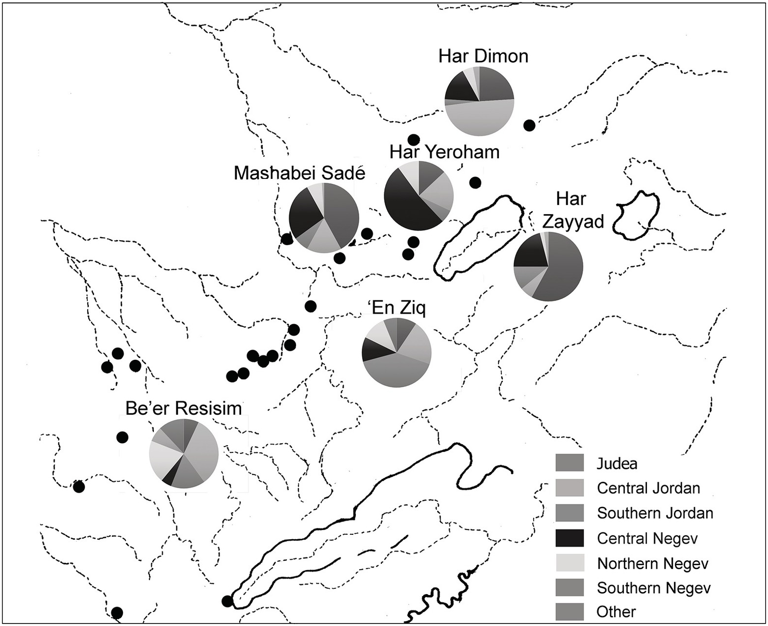
Provenience studies of ceramics from ‘En Ziq and Be’er Resisim, as well as several contemporary sites in the Negev, reveals a truly remarkable diversity of ceramic sources (Figure 4.10).81 At both sites, ceramics originating in central and southern Transjordan account for 50–60 percent of the total samples studied (a bias toward the sampling of red-slipped wares, some of which could date to EB III, has probably inflated the true proportion, in this case), with the remainder being split between the Judean hills, the central Negev (most likely, the Har Yeroham workshop) and the northern Negev or southern plains. All the other sites sampled show a dominance of imported ceramics, either from the north or the east, with the only exception being Har Yeroḥam, which – at least for a time – modeled itself on the sedentary, agricultural villages of the north and produced its own pottery.
The above sites may be contrasted with the typical traditional desert settlements, whose character had changed very little since Neolithic times (hence their inclusion under the rubric of “terminal Timnian”). Excavations at one of the smaller sites at the western margins of the highlands, Rogem Be’erotayim, recovered a small and uniform ceramic assemblage, comprised largely of holemouth vessels, storage jars and, significantly, cups.82 The lithic assemblage was the product of a local ad hoc flake industry, and had a large component of microdrills, probably used in bead production. Mammal bones indicate the consumption of mature sheep and goats, probably raised for their secondary products. The presence of wild species indicates local procurement of food, while a few fish bones point to exchange of foodstuffs, perhaps with travelers along the north–south and east–west interregional routes that pass near the site. A study of butchering marks on the bones indicated the use of stone tools only, and no copper tools were found in the excavation.
‘En Ziq, Be’er Resisim and other sites of the same type (such as Mash’abei Sadeh, Meẓudat Har Ẓayyad and Nahal Boqer) thus stand out as implants in the IBA settlement landscape, differing from the myriad small sites in the long-standing Timnian tradition, on the one hand, and from isolated attempts to establish agricultural outposts, like Har Yeroḥam, on the other. They had no productive capacity, but were avid consumers of local (food) and imported (ceramic) resources. These, clearly, are not the permanent agricultural settlements proposed by Cohen, nor the pastoral-nomadic campsites proposed by Dever. Rather, they have the character of boomtowns – rapidly built and soon abandoned – that appear in conjunction with the discovery or development of previously untapped resources. Haiman was the first to suggest that the rapid rise of these settlements should be associated with the rise of an organized copper trade between the Arabah Valley and Egypt, at a time when Egypt was entering a period of political uncertainty, the First Intermediate Period, which could have been viewed as a period of opportunity for non-state actors. In this view, some of the secondary processing of metal ores into small ingots occurred at the large “permanent” sites in the central highlands. The ingots could then be distributed westwards, toward the main market for copper in Egypt, or northward, to the secondary Levantine market, where they would be converted into finished products. Yekutieli, who excavated an IBA smelting site at ‘En Yahav, about 30 kilometers east of the ore sources in Wadi Feinan, seconded Haiman, while proposing that the highland sites represent a tool-production zone within the Arabah–Negev metallurgical complex.83 The main relevant production site in Wadi Feinan is Khirbet Hamra Ifdan (KHI), which has already been described in Chapter 3 as an EB III site, and indeed the main phase of activity at KHI is the earlier phase, which spans the twenty-sixth to twenty-fifth centuries and which has a ceramic inventory that lacks IBA characteristics. It is this phase that produced casting molds for pins, axes and ingots, which could indeed have been sent westward to the first settlers in the highland sites (Figure 4.11).84 However, the phase in which typical IBA pottery appears at KHI and to which the ‘En Yahav site is radiometrically dated falls at the very end of the IBA, in the twenty-first century BCE. The early phase, when KHI was at the height of its activity and produced its own ingots and finished products, cannot be correlated with the First Intermediate Period, nor can a market or a route for Arabah copper to Egypt be substantiated for the twenty-fifth century. Thus, faced with chronological inconsistencies and the lack of direct evidence for metalworking in the highlands, the “copper boom” theory for the large Negev settlements lacks a convincing context, and thus fares little better than earlier theories.
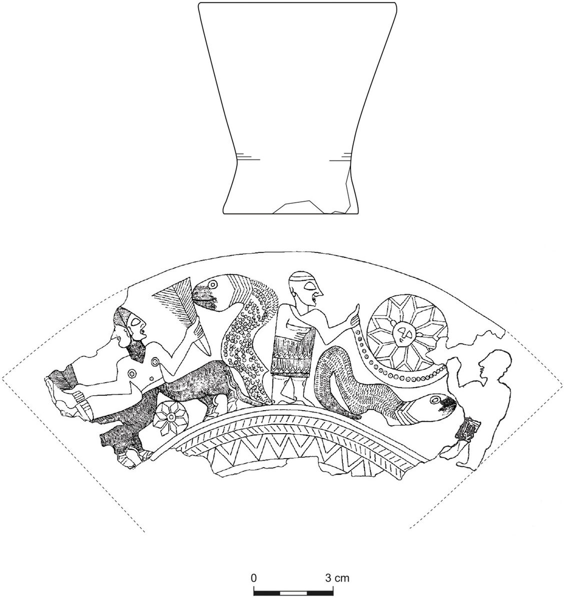
Still, a small line in copper could have been part of a different economic mechanism that attracted hundreds of colonists from Transjordan and the southern plains and hills to the Negev Highlands. If we zoom out from the local desert dynamics, as we must, to accommodate the evidence for interregional movement of goods and people, one of the most significant changes in the global Near Eastern economy was occurring some distance to the north, in western Syria. There, as noted earlier, Ebla and neighboring states were emerging as political and economic powerhouses, resting on the two pillars of dry-farming and sheep-herding.85 Wool had become a commodity, textile production was institutionalized, and the production of wool and hides features regularly in mid-third-millennium texts.86 The sheer numbers of sheep required for the palatial economy of Ebla alone would have required management of herds situated outside the farming lands, in the semi-arid margins, well away from the urban centers.87 The evidence for Syrian cultural impact on the southern Levant, whether in the ceramic inventory and the consumption habits associated with it or in symbolic artifacts such as the ‘Ain Samiya cup (see the box below on “The ‘Ain Samiya Goblet”) or the nude figurine from Jebel Qa‘aqir, speaks to the possibility of an economic knock-on effect as well: the incorporation of pastoral economies of the southern Levant into the global textile economy centered in western Syria. Wool production had never been prominent in south Levantine EB III towns, if we may judge by the lack of evidence for weaving at these sites. EBA herds were managed mainly for their meat supply. Now, for the first time, wool- and hide-producing herds were to be managed as an economic venture, rather than as a mode of subsistence, and this could be best effected outside the agricultural zone, along the eastern margins and in the Negev Highlands. The Negev Highlands “boomtowns” were thus the product of economic entrepreneurship, which would have included the raising of large herds by the traditional desert pastoralists, augmented with settled-zone pastoralists, and either
(1) the transport of some these herds northward, on the hoof, on an eastern route through the Transjordanian plateau to the Hauran and thence to the edges of the areas of direct interaction with Syrian urban economies, or on a western route along the traditional coastal and valley route, or
(2) the shipment of wool and hides from the processing sites in the Negev, either along an eastern route, with the aid of mobile intermediaries who straddled the Syrian and south Levantine pasturelands, or a western route, linked to the coastal sites and the still-extant Byblos maritime route.88
This hypothesis may be the most parsimonious explanation for all the elements comprising the IBA settlement surge in the Negev.
The Living Dead
More than 100 shaft-tomb cemeteries and untold numbers of above-ground mortuary monuments have made the IBA a byword in the study of Levantine mortuary practice (and in the annals of antiquities looting, which thrives on the gifts interred with the dead). Shaft tombs and shaft-tomb cemeteries have been excavated along the rift valley, from the Dead Sea to the Biqa‘, in the Jezreel Valley, along the Mediterranean coast, in the Galilean and central hills (especially the central and southern zones) and in the Transjordanian plateau. Major cemeteries include those near the mounds of Jericho, Megiddo, Bet Shean, Lachish, ‘Ajjul and Bab edh-Dhra‘;89 coastal cemeteries at Azor, Yehud, Bet Dagan, Ma‘abarot and ‘Ein Assawir;90 Jordan Valley cemeteries at Hagosherim, Tel ‘Amal, Tiwal ash-Sharqi and Wadi al-Hammah;91 and the central hill cemeteries of ‘Ain Samiya/Dhahr Mirzbaneh, el-Jib, Efrata, Kirmil and Jebel Qa‘aqir.92 Tumulus and dolmen cemeteries attributed to the IBA are found in the Golan and Upper Galilee, in the Carmel range, along the eastern side of the rift valley and in the Negev Highlands.93
The seeming disparity between extensive cemeteries and an impoverished settlement landscape gave rise to many social and historical models that viewed the IBA as a period of widespread nomadization.94 People who were constantly on the move, it was thought, would become sedentary, hence visible, only at death. But we have already seen that IBA people are not, in fact, so elusive, especially if one looks away from the great mounds. Moreover, because the IBA accorded much effort to individual interments, the numbers of the dead are less overwhelming than might have been expected from the sheer number of tombs. In fact, the prominence of IBA tombs and mortuary assemblages is more an economic than a demographic fact: IBA tombs indeed involved a remarkable expenditure of energy on thousands of subterranean shaft and chamber tombs and above-ground tumuli and dolmens, but the prevalence of individual adult burials, at the expense of collective burials, which are rare, translates into a relatively small population of IBA people in tombs, when compared with other burial-rich periods, such as the EB IB or MBA. Thus, at Jericho, about 350 adults and 20 subadults (based on counts by Kenyon and Greener)95 were interred in about 360 tombs, presumably over two or three centuries. By way of comparison, in three burial caves alone of the late EB I there were remains of 420 individuals.96 Significantly, all IBA burials took place outside the settlements, in designated cemeteries. Thus, mortuary treatment and ceremony were more about the reinforcement of communal claims to land and to memory, and less about the reintegration of the dead into the community.
Several attempts have been made to create a typology of IBA tombs, focusing on their technical characteristics.97 The resulting distribution maps are instructive of the variety of approaches taken throughout the region – Z. Greenhut identified fourteen tomb types – and even at individual sites, with Jericho, home to several different tomb-cutting practices, being an oft-studied case in point.98 But the distribution of tomb-types has yet to be successfully correlated with any other significant characterization of the communities in question. Those seeking chronological resolution for the 400-year period can show no convincing chronological seriation, while the attributions of differences to cultural origin or social standing falter on the arbitrary determinations required to define values such as status and wealth, and on the absence both of bio-archaeological data and of secure comparative assemblages in the living communities that could be associated with the cemeteries.
A focus on the tombs as places of commemoration, of the negotiation of social status and of territorial precedence – that is, on the how of mortuary practice rather than on the why – might provide a more informative window into IBA communities and into their social priorities, especially in relation to the preceding and succeeding periods. This focus can be achieved by considering significant choices made during the mortuary process itself; that is, under what terms were the departed required to successfully (and permanently) complete the passage from the world of the living to that of the dead, and the survivors to complete the transformation, in their minds, of living presence into memory. In the wake of several centuries during which the communal commemoration of the dead was suppressed by urbanizing ideologies, mortuary traditions had virtually to be reinvented by IBA people. They had two surviving templates to draw upon: the megalith and tumulus tradition maintained by mobile populations, mainly in the semi-arid margins, and the collective cave-burial tradition that had survived only in the rift valley, between Jericho and the southeastern Dead Sea plain. Placing the megalithic cist tomb and the cave tomb at the two extremes of the mortuary spectrum (individualizing and visible, vs. collective and subterranean), the variations in IBA mortuary practice can all be placed on a continuum between them, often combining or negotiating between their chief attributes. Whatever their choices, it can hardly be doubted that IBA people put a premium on the presencing of the dead, restoring the power of ancestors in their post-urban landscape.
Type A, Individualizing Tombs
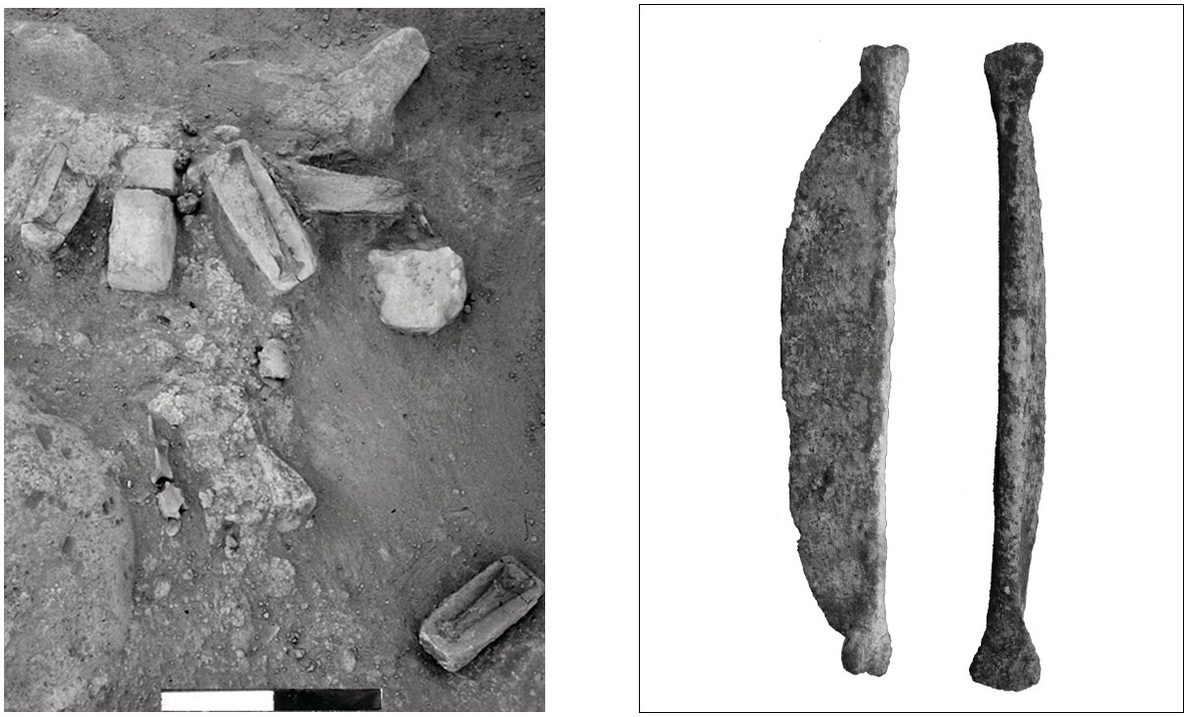
A recurring category that cuts across regions and grave or tomb types is the singular, articulated male dagger-burial (these are nearly always single burials, but the occasional double burial is included in this category, as it represents a single event of inhumation). The clearest performance of this type of interment can be seen in stone-lined cist or chamber tombs excavated at Tell el-‘Ajjul.99 In these tombs, most of which were oriented to the east, an articulated male skeleton was placed in a fetal position on its right side, with a dagger at its waist. Accompanying finds could include a jar, cuts of meat or personal ornaments. These tombs were sealed with large slabs and never reentered, though they were probably visible on the surface. Similar constructed, slab-roofed cist tombs were excavated at Tiwal ash-Sharqi in the eastern Jordan Valley,100 and as noted by Tubb, they seem to be derived from above-ground cairns with central cists, of the type prevalent along the rift valley and in the hilly regions and excavated, for example, at Ramat Hanadiv, at the southern tip of the Carmel range (Figure 4.12).101 At that site – a mid-third-millennium seasonal burial site associated with transhumant pastoralists – about forty burial cairns were identified, all oriented toward the setting sun. Three of the twenty excavated tombs contained weapons – a dagger and two mace heads – but no other artifacts. Other members of this class might include circle dolmens of the northern Jordan Valley and the adjacent plateaus, both east and west; tumuli in the central hills; and some of the Negev Highlands tumuli.102 In all cases, burials were a singular event, probably conducted soon after death, but they created a highly visible mark in the landscape that could serve as the focus of commemorative performances, attract additional burials and signal territorial claims.103

Figure 4.12 Type A individualizing tombs at Ramat Hanadiv (after Greenberg Reference Greenberg and Hirschfeld2000: figs. 6, 11) and Jericho (after Kenyon Reference Kenyon1965: figs 24, 26); daggers are scaled approximately 1:8. Type B collective tombs at Hazorea‘ (after Meyerhof Reference Meyerhof1989: figs. 7, 8) and Jericho (after Kenyon Reference Kenyon1965: fig. 66).
Sharing most of the attributes of the built graves are the “dagger” and “composite” shaft tombs of the Jericho necropolis, as defined by Kathleen Kenyon.104 The former are small tombs where articulated adult skeletons (all male, when identified), placed on their right side, are provided with daggers and an occasional personal ornament, but no pottery (Figure 4.12). The latter are like the “dagger” tombs, but they contain pottery and additional items of personal adornment. The “dagger” tombs, differing in size and content from all other tombs at Jericho, occupy a defined portion of the cemetery, but they do not seem to have been marked above-ground. The use of chamber tombs for a one-off ceremony is perplexing, since the point of having a sealed, accessible chamber is to allow periodic reentry (see below). But the concentration of these tombs in a specific zone within the cemetery suggests that their inhabitants were all considered peers, and that – as in the case of cairn-fields and other cemeteries composed of marked graves (including modern ones) – the relevant reference group is the entire community, rather than the immediate kin of the deceased. Thus, rather than patresfamilias, the men in question were perceived (or at least presented) as “pillars of the community.”
A significant attribute of these tombs is their pronounced gender identification, underscored by the interment of a dagger, worn at the waist, often to the exclusion of anything but a few items of personal adornment. All the daggers that have been in analyzed in this class of burial proved to have been made of copper alloy, containing 1–5 percent arsenic.105 Since local copper, familiar from the Wadi Arabah production sites and the Negev Highlands ingots, contains only traces of arsenic, the presence of arsenical alloys suggests input from northern copper sources. The daggers therefore carried added value, as exotic items obtained by way of extended networks of exchange or by dint of long-distance travel. Their interment at the waist of the men who wore them points to their being inalienable objects that could not be separated from their owners without risk of offending them, even after death. In other words, they were, in life, a determinant of identity or parts of a new entity – “a man with a fine dagger” (often characterized as a warrior) – that is no longer reducible to its components,106 and, in death, a fitting gift that ensured the maintenance of mutual obligations between the living and the dead.
Type B, Communal Tombs
The archetype for the IBA communal tomb is the remarkable group of multichambered shaft tombs from Megiddo and Hazorea‘.107 Typically, these tombs have a quatrefoil plan, with a square shaft on one side leading to a square central chamber that provides access to three rectangular chambers, one on each side. Since the Megiddo tombs were all compromised by later use in antiquity, the comparable tombs at Hazorea‘, sealed in antiquity, might help illustrate their use. In Tomb 3, the largest and best preserved of the tombs at Hazorea‘, no articulated skeletal remains were found, but only numerous bone fragments that carpeted the central room and extended into the two lateral chambers, one of which was furnished with benches (Figure 2.12). Wide and deep troughs were cut into the floor of the lateral chambers and then covered with paving stones. Apart from a few pins, a copper knife, and a bead, finds consisted of a large collection of ceramics, among them thirty-eight jugs, thirty teapots, a cooking pot and several other containers, and several simple flint flake and blade tools. The other tombs at Hazorea‘, although smaller in size, yielded comparable finds. The surviving inventories at Megiddo are remarkably similar, with quantities of teapots and jugs, but very few other objects or personal effects of the departed.
There is little doubt that these tombs served as repositories for secondary interments but, more importantly, as places of periodic – perhaps even scheduled – commemorative performances that included the pouring-out of liquids into the carved troughs and the consumption of food and drink. The complete disintegration of the skeletal material should also be taken as intentional, as it is repeated in countless IBA tombs. It represents the final stage in a prolonged rite of passage for the departed that offers a sharp contrast to the Type A tombs: (1) primary defleshing (outside the tomb), (2) disarticulation and collection, (3) deposition in tomb and (4) fragmentation and mingling with ancestral remains. By the end of this process, the individual has been completely subsumed in the ancestral group and can no longer be identified.
Like the Type A individual monument, which finds its origin in long-standing commemorative practices of the marginal zones, the Type B collective hypogeum seems to be a concept shared across large parts of third millennium western Asia. A remarkable juxtaposition and continuous reformulation of these two approaches to commemoration occurs at Tell Banat, on the Syrian Euphrates, as discussed by Anne Porter.108 There, massive above-ground burial monuments – the White Monument outside the mound and the Mortuary Monument on the mound – belong to the widespread practice, from the Euphrates down to the Levant, of enabling the cohesion of far-flung pastoral societies by “the reproduction of territorial and descent-based relationships through ancestor burials contained in massive built structures,” while a remarkable, ashlar-built subterranean chamber tomb (Tomb 7), very similar in plan to the Megiddo and Hazorea‘ tombs, represents the concentration of power with specific descent-lines in the same societies.
Most of the IBA tombs in the Levant can be placed on a spectrum between Type A – singular burials of prominent men – and Type B – communal tombs of nuclear or extended families. Closest to Type A are shaft tombs containing primary burials of males with daggers that provide evidence for a more extended ritual, or of several burial episodes. A relatively large, but damaged, cave excavated at Moza, near Jerusalem, contained one surviving supine burial, four jars, a tanged copper spearhead, two tin bronze daggers, copper studs and a decorated copper belt (?).109 It seems likely that this cave was entered more than once. Tomb 1 at Horshim, on the coastal plain, contained three primary burials, one of which was provided with a tin bronze dagger.110
A different approach, also related to Type A burials, is the extension of the single-interment shaft tomb concept to entire cemeteries. This approach characterizes several cemeteries in the central coastal zone, in the Yarkon and Ayyalon River basins, where large numbers of shaft tombs were found, each containing a single primary interment of a man, woman or child, provided with a nearly identical “burial kit,” usually comprised of a jar, a cup and a lamp.111 These individual tombs are only slightly removed from the simple pit tombs that characterize the coastal region in the second millennium BCE, suggesting that the physical affordances of the coastal lithology might have affected the choice of burial patterns. In such cemeteries, the uniform personal inventories underscore the collective ethos: all the interred belong to the community as a whole, rather than to their immediate kin.
Several tombs combine the concepts of individual and communal burial. Two slab-lined shaft tombs at Deganya, just south of Tel Bet Yerah, seem to have been family tombs.112 The better-preserved of the two contained six primary burials – three adult males, an elderly female and two children – accompanied by a single spouted pot and three daggers, one of them of made of tin bronze.
A bilobate tomb at ‘Enan contained, in one chamber, a single adult male in primary articulation, accompanied by five daggers, apparently all of tin-bronze, a whetstone, a spearhead, an arrowhead, three copper pins, and ceramic lamps, amphoriskoi, jars and cooking pots.113 In the second chamber there were two adult males, one adult female, a child and an infant. Here too, the males were provided with daggers and a whetstone, and the female with rings, bracelets and a 49.5-centimeter-long toggle pin. Ceramics here included cups, teapots and broad-spouted pouring vessels, or askoi, in addition to the other types. A trough between the two chambers contained, among other things, a group of spearheads.
There are several additional examples of tombs with multiple primary burials where males were provided with daggers – often of tin bronze that could have been obtained only in Syria – but were interred alongside others, in tombs that were clearly reentered periodically and which served as a venue of rituals that included pouring and consumption of beverages.114 These tombs thus combine abbreviated mortuary treatment of the deceased with more extended familial commemoration within the tomb. While these tombs accord males “warrior” status, the tombs at Tel ‘Amal illustrate the reopening of tombs for additional burials and for commemorative meals, without gender differentiation among the primary interments, which remained intact.115 Tombs of this type are thus further removed from Type A, moving closer to Type B.
Most shaft tombs in the hill regions and the interior valleys belong to cemeteries containing scores or hundreds of shaft tombs, usually clustered on hillslopes in discrete groups that betray a degree of planning and institutional memory. The phenomenon of empty tombs has been recorded in several cases, and a detailed study of one of Jericho’s standard tombs revealed that it had lain open and unused for weeks before it was put into use.116 This can be taken as evidence of preparation for burial in the context of the “long” mortuary treatment that we have associated with Type B communal tombs. In most of these tombs there are fragmentary skeletal remains, nearly always representing only a small part of the original skeleton, belonging to one or two persons. But there are nearly always outliers that are larger than the others, or that contain remains of several persons or greater quantities of ceramic containers (Figure 2.12, bottom). Often, tombs show clear signs of reentry such as the repeated use of lamps, placed in lamp niches, the rearrangement of finds within the tombs, the introduction of food remains or various modifications of the shaft (such as the addition of incised graffiti).117 These and other variations have been cited as evidence of status disparity and display in IBA society,118 but if so, it is only limited disparity, of the same order as that exhibited between larger and smaller households in the settlements. Where there were more family members available to assist in the preparation of the tomb, or more participants in, or iterations of, the burial rites, we may find larger tombs or bigger inventories. The ‘Enan tomb described above, with its rich cache of exotic weapons, personal ornaments and serving vessels, might be the only clear-cut display of conspicuous consumption in the IBA mortuary contexts.
Broadly speaking, the huge cemeteries in the middle and southern zones of the central hills (e.g., ‘Ain Samiya/Dhahr Mirzbaneh, with 1,100 tombs, and Kirmil, with 850) have a preponderance of single or double disarticulated inhumations in shaft tombs, seemingly truncating the full Type B treatment before the final step of “mingling with the ancestors.” This would indicate that the collective identity, represented by all those interred in each cemetery, was still a powerful force, competing with the familial one. Greenhut has suggested that each of these cemeteries was marked by a hilltop tumulus or cultic platform, such as indeed have been excavated at Efrata, Dhahr Mirzbaneh and Jebel Qa‘aqir.119 Such installations would have served both as a visible marker of the subsurface tombs on the hillslopes and as a possible venue for the pre-burial rites. Evidence of a different kind of setting for collective mortuary rites comes from Qedesh, in the Upper Galilee, where a huge collection of pottery, including numerous cooking vessels, lamps and drinking sets was found along with a small number of human and animal bones in an artificial cave that was provided with a central trough and a modeled pillar, in which a shelf and niche were carved.120 These seem to be remnants of mortuary feasts, perhaps associated with the collection and redistribution of bones of the dead in the process of secondary interment.
The negotiation evident in the mortuary practices of the IBA, between those typically associated with mobile populations (Type A) and those typically associated with sedentary village agriculturalists (Type B), must reflect the revived importance of these two modes of post-urban existence, which had been suppressed during the first half of the millennium, and the interpenetration of values between them. The many local variations visible in cemeteries are doubtless a reflection of the length of the period, the diversity of regional identities (as expressed, for example, in the ceramic industries) and the fact that the mortuary tradition had to be reinvented after the EB II and III, when familial and tribal support structures were suppressed. The relative wealth of finds in the tombs – especially of precious metal weapons and personal ornaments – is a reminder of the retreat from the urbanizing economies of accumulation and commodity production, and a return to an economy in which the mutual fulfillment of obligations – including those of the living to the dead – was of paramount importance.
Summary: The Long Intermediate Bronze Age
With many fortified centers abandoned by 2500 BCE, and the few settled towns hanging on for only a few decades more, the south Levantine countryside (and a good part of the central Levantine coast as well) had completed its transformation into a post-urban landscape by 2400 BCE, an orientation that was to last until 2000 BCE and beyond. Mounds and urban ruins were still prominent in the countryside, but the builders of the new settlements avoided them, for the most part, instead establishing small villages in the agricultural heartland as well as in marginal areas suited for agro-pastoral economic strategies. A very prominent mortuary culture, often encircling abandoned mounds, appears to represent lingering territorial claims of an earlier era. Cemeteries reproduced tribal or familial relationships and reestablished the centrality of ancestral claims; their prominence – and the concurrent absence of formal religious establishments – underscores the rejection by IBA people of the hierarchical structures of the late EBA.
Table 4.1 Suggested matrix for IBA mortuary treatment, with the binary types at either end and the rest arranged on a continuum between them
Readjustments of synchronisms with neighboring regions allow us to associate prominent elements of IBA material culture with contemporary cities and states of Early Bronze IV Syria. These include prestige objects directly imported from the north (such as silver and bronze jewelry and weapons), Syrian-inspired ceramic technologies, and the emulation, in local technologies, of Syrian ceramic forms. Continuing work on the pastoral economy of Ebla and its neighbors indicates that wool and textiles were at the heart of the northwest Syrian economy, suggesting a knock-on effect in the Levantine margins that would have elevated the prestige of local potentates controlling large herds of sheep. The possible impact of climate deterioration in the last quarter of the third millennium on settlement in the southern Levant should be accommodated within this revised view of north–south Levantine interaction: drought would not have precipitated the onset of the IBA, but it could have had a role within it, and might be implicated in the early abandonment of Negev Highlands sites, in the first half of the period.
There can be little doubt that cultural preconceptions about the “inhospitable Negev desert” underlay the mid-twentieth-century archaeological reaction to the discovery of a dense network of IBA settlement across the Negev and Sinai highlands. While interruptions in the settlement history of virtually every geographical region and all but the most prominent tells of the Mediterranean zone did not seem to call for comment, the “unprecedented” spread of settlement in the IBA Negev and Sinai required a compelling external cause: for Albright and Glueck, it represented the tribal-nomadic milieu of the biblical patriarchs, descending – like them – from the north, in search of pasture and of trading routes;121 for Kenyon, it was evidence of EBA civilization overrun by Amorite nomads;122 Lapp, Kochavi and Aharoni also saw an invasion, but of kurgan-building nomads from the distant north;123 and R. Cohen suggested that IBA settlement spread eastward from Sinai, and was later reimagined and retold as the Israelite exodus from Egypt.124 None of these scenarios, each based on a kernel of evidence, has stood the test of time, as extensive surveys and off-tell excavations have piled up the evidence for significant rural settlement in the traditional, Mediterranean zones, while the arid-zone settlement proves, upon close examination, to have been short-lived and dependent on sedentary-zone settlement. Rather, it is the processual approach of Dever, Richard and especially Palumbo,125 with its emphasis on rural resilience, that can best be squared with the evidence in hand, but with the following proviso: the village settlement of the Mediterranean zone, as a reinvented social form, was only indirectly related to the preceding EBA; rather, it is a product of a negotiation between surviving urban technologies, pre-existing non-urban groups, and incoming ideas spawned by mobility, trade and new economic opportunities. In spite of the seeming isolation and parochiality of the villages and herders of the Levant during the latter centuries of the third millennium, the IBA was in fact a period of increased connectivity, when compared with the late EBA; without centers of their own, Levantine people seem to have been attuned to the nuances of cultural and political change in neighboring regions. It should therefore come as no surprise that, with the turn of the millennium, the transformations affecting northern and western Syria – what has there been termed the “regeneration” of urban society126 – should have impinged on the central and southern Levant as well, as a new, Middle Bronze Age order was about to be established.
The ‘Ain Samiya Goblet
The ‘Ain Samiya goblet (Figure 4.13) is a diminutive silver cup with splayed sides and a flat base, similar in form to ceramic cups that occur, albeit rarely, in third-millennium assemblages of both the Early and Intermediate Bronze Ages. It was found in an unremarkable shaft tomb of a type common in the central hills, together with a ceramic assemblage consisting entirely of cylindrical cups, two four-spouted lamps and three copper weapons. The external surface of the cup was occupied by a complex mythological tableau, executed in repoussé and chasing. Two scenes are depicted. In the scene conventionally depicted on the left, a figure with two human faces in profile, set atop a frontal human torso, which itself rests on two pairs of bulls’ hindquarters, again in profile, and a small sun-disk, wards off a rearing serpent with a plant-like staff; in the scene conventionally shown to the right, two human figures clad in woolen garments hold a crescent-shaped object that appears to define a celestial sphere, in which a large human-featured sun-disk is shown, and a nether sphere, to which the serpent is relegated. The human faces, serpent and sun-disk are shared between the two scenes, which might therefore be interpreted to represent two sequential states within a single narrative. Yadin linked the tableau to the Mesopotamian creation myth. M. Tadmor expressed reservations about the linkage, while Carre-Gates (1986) proposed a Hurrian iconographic milieu for the vessel, with ultimate origins in the northern Caucasus.127

Figure 4.13 The ‘Ain Samiya goblet.
The latter suggestion, along with Tadmor’s observation that the cup was introduced into the tomb in an already-broken state, is intriguing. In the absence of a local context for the creation and formal use of a ceremonial object of this caliber, we must assume a long line of transmission – or an extended biography – for this object. There seem to be two options for such a biography: the Syro-Mesopotamian option would place the origin of the vessel in the late third millennium Syrian interaction sphere, linking it to the scenario that connects the Levantine IBA to the integration of peripheral groups into the textile economy of Ebla and neighboring city-states. The Caucasian option could point in a different direction: the ‘Ain Samiya tomb is not too distant from the abandoned EBA town of ‘Ai, where a temple, a shrine, and the presence of KKW producers/users were all recorded. The ‘Ain Samiya cup may thus have originated in EB III ‘Ai, to be eventually deposited as an heirloom in the nearby IBA cemetery.