


During the Middle Neolithic (4500–3500 BC), the funerary megalithic architecture in Brittany, France, is almost exclusively found around the coast (Giot et al. Reference Giot, L'helgouac’h and Monnier1998; Scarre Reference Scarre2011). Only two sites are known from the inland area of Brittany: Ty Floc'h at Saint-Thois and Croaz Dom Herry at Saint-Nicolas-du-Pelem (Le Roux et al. Reference Le Roux, Lecerf and Giot1980; Tinevez et al. Reference Tinevez, Nicolas, Gaume, Querre and Quesnel2012) (Figure 1). This distinct geographic distribution has been attributed to geological factors, as few substrates of the region are suitable for the extraction of megalithic blocks (L'Helgouach Reference L'Helgouach1965). During the Late Neolithic (3500–2500 BC), this trend is reversed, with a high density of allées couvertes (gallery graves) everywhere (Scarre Reference Scarre2011). Demographic studies of Neolithic populations often rely on these monuments and their known distribution because few settlements are recognised (Hénaff Reference Hénaff2002). The proliferation of megalithic architecture around the coast in the Middle Neolithic is interpreted as representing population density on the seaboard (Scarre Reference Scarre2011), and as reflecting a society with symbolic and economic maritime influences (Cassen Reference Cassen2000). The discovery of new monuments in central Brittany challenges this interpretation.

Figure 1. Location of the Goasseac'h cairn in central Brittany and other Middle Neolithic funerary monuments, including sites mentioned in text (after Giot et al. Reference Giot, L'helgouac’h and Monnier1998, modified by Scarre Reference Scarre2011; figure by L. Quesnel & F. Cousseau).
The town of Carhaix-Plouguer, in the Finistère region, is famous as the site of the Roman city of Vorgium. A few kilometres south of this site is a mound 120m long, 40m wide and 1.5m high, on a slope oriented to the south-east (Figure 2). Formed only by greywacke sandstone blocks, it contrasts sharply with the surrounding silty substrate. Although the mound was identified in 1984 by the Breton archaeological service as a potential ruined megalithic monument, the paucity of large stone blocks and the known Roman/medieval archaeological landscape around it meant that doubt remained concerning its chronological attribution. The research project led by Florian Cousseau (University of Geneva, Switzerland, and UMR6566-CReAAH, CNRS, France) aimed to determine whether the Goasseac'h mound constitutes a megalithic monument.
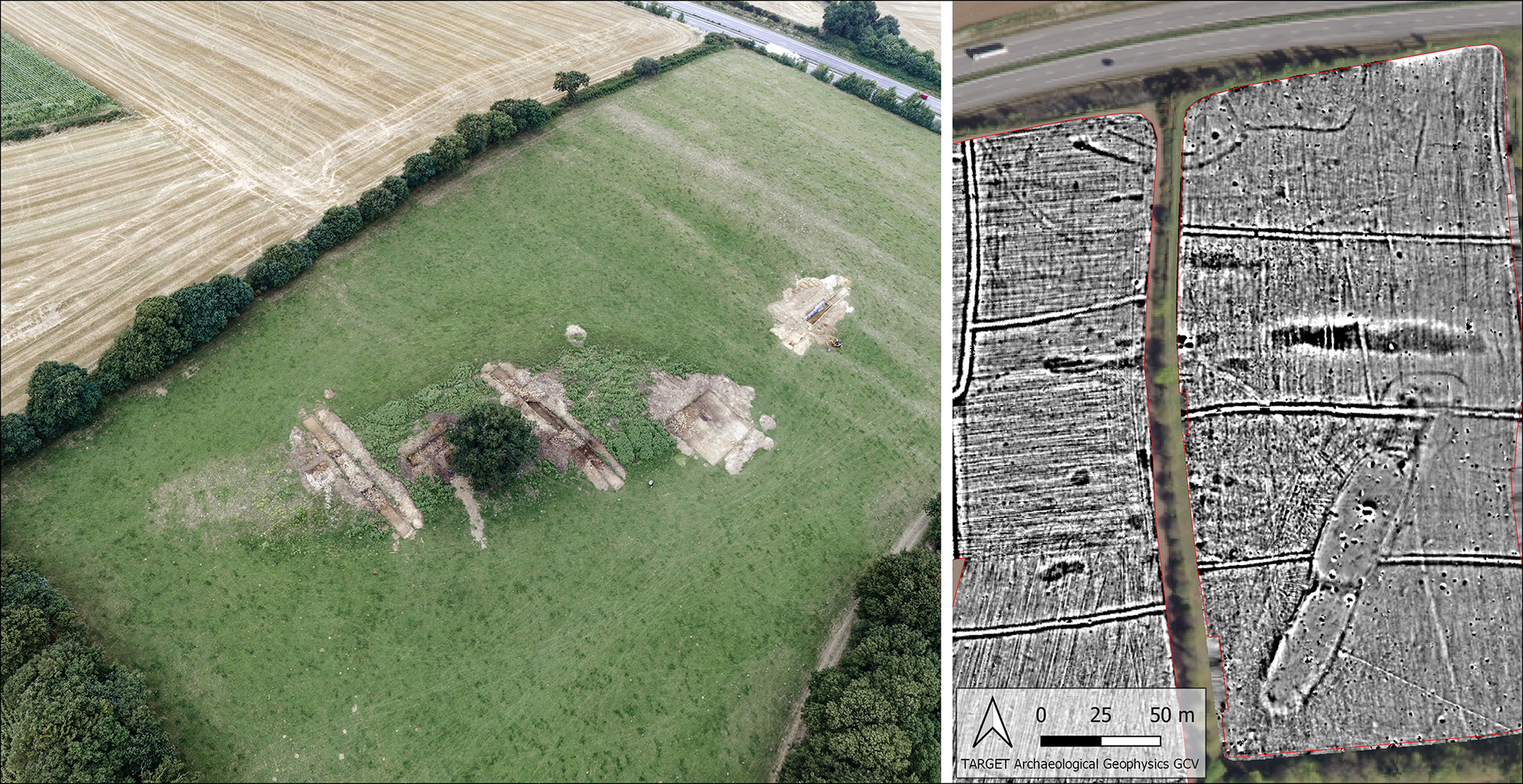
Figure 2. Left) drone view of the mound: the intact burial chambers are visible in the test pits to the left, and the quarry to the right of the photograph (photograph by Virtual-Archeo); right) magnetic cartography around the mound (survey by John Nicholls/TARGET).
The project began with geophysical surveys. The results showed that the field in which the mound is located is particularly rich in archaeological remains (Figure 2). The mound itself is visible in the southern part of the plot. To the north are several hollows, including one that extends 80m; these are interpreted as quarries. Several structures were also identified: two medieval-style enclosures at the northern limit of the field, and a third constructed to the north of the mound. The monument itself appears to be surrounded by an enclosure. The georadar survey undertaken on the south-west part of the mound revealed large anomalies within the monument, perhaps megalithic chambers. These initial results indicated significant archaeological remains within the field and on the mound, some of which represented complex architecture possibly with internal structures.
The wider area of Carhaix-Plouguer did not yield any evidence for prehistoric occupation prior to the two Neolithic occupation phases discovered during rescue excavations at the Kergorvo ZAC site (Le Boulanger Reference Le Boulanger2011; Toron Reference Toron2013). During the first phase (fifth millennium BC), two buildings with disjointed posts were erected, while during the second (Final Neolithic to Bronze Age transition), an almond-shaped building was constructed (Blanchet et al. Reference Blanchet, Nicolas and Toron2012). This discovery is of crucial importance to our knowledge of Neolithic settlements in Brittany, and demonstrates that Carhaix-Plouguer was indeed occupied during that period.
A multi-chambered long cairn
Following the geophysical surveys, a test pit campaign was conducted on the site of Goasseac'h, with six trenches opened (Figure 2). The first, and most northerly trench, confirmed the presence of a quarry over 2m deep, and confirmed that the local substratum is unsuitable for large-block extraction. Indeed, for 15km around the cairn, the maximum block size is 0.5m.
The five other trenches were situated on the mound itself. Surface cleaning revealed dry-stone walls constructed along the length of the mound and following its orientation. The large size of the stones that comprised the wall are consistent with the hypothesis of a monumental façade (Figure 3). The other walls are internal, forming a complex network structuring the general mass of the edifice. This architecture is typical of megalithic monuments of western France (Laporte Reference Laporte, Laporte and Scarre2015).

Figure 3. Façades of the cairn: north-west (left and upper right), and south-east (lower-right) (photographs by F. Cousseau).
The presence of a Middle Neolithic cairn was confirmed by the discovery of three adjoining passage graves, oriented towards the south-east. The central chamber is circular, with a diameter of 3.5m (Figure 4). During excavation, the ruins of its original corbelled vault were discovered, overlying 1m of fill and indicating that the chamber has remained unexplored since its roof collapsed. The western extremity of the chamber, however, has been cut by a more recent occupation, leaving the top of the chamber fill exposed. A broken Maritime Bell Beaker vase (2500–2200 BC) was found on top of this fill, providing a final occupation period for this dolmen. This exceptional preservation suggests that the funerary levels between the Middle Neolithic and the Bell Beaker period are still in place; it is unfortunate that the acidity of the soil prevents the preservation of bones.

Figure 4. Passage grave with an axial passage and corbelled vault collapsed onto the yellow fill of its circular chamber (photographs by F. Cousseau).
Conclusion
Our research has shown that Goasseac'h mound of Carhaix-Plouguer is the ruin of a Neolithic cairn, constructed almost entirely of dry stone. The exact dimensions of the monument are still to be established, with a current estimate of 90m long by 10–15m wide. It remains unclear whether the mound incorporates one or two cairns. The southern half of the mound certainly accommodates three funerary spaces, and perhaps more. The centre of the northern part of the mound has been the target of stone-robbing, destroying the passage graves but not the façades. This intrusion allowed access to a Neolithic floor surface with a dense charcoal presence, from which radiocarbon dating of a twig returned a date of 5334±24 BP (ETH-104278: 4253–4053 cal BC at 95.4%). The building techniques, dimensions of the monument, density of chambers and the location of the Goasseac'h cairn on sloping ground are all strongly evocative of the Barnenez monument at Plouezoc'h (Figure 5). Elevation drawings and analyses made of the surviving cairn at Barnenez will enable technical and architectural comparisons between the two sites and their evolution (Cousseau Reference Cousseau2016, Reference Cousseau, Cousseau and Laporte2020).

Figure 5. Comparison between the sites of Goasseac'h (above) and Barnenez (below) (photographs by F. Cousseau).
The discovery of an unidentified long cairn is a rare occurrence for megalithic research in western France, even more so within central Brittany. It challenges current understanding of the distribution of dolmens in Brittany, which might not accurately reflect Middle Neolithic society. The site of Goasseac'h offers an exceptional research opportunity, for the study of both the architecture and the burial chambers. Moreover, the identification of a Neolithic settlement at Kergorvo, 4km from Goasseac'h, opens up new lines of enquiry into the relationship between settlements and funerary structures. Continuing excavations at Goasseac'h should yield important new insights into megalithic monuments and the Neolithic of western France.
Acknowledgements
We wish to thank the landowner Loïc Lucas, and Claudine Abegg for the translation.
Funding statement
The French Ministère de la Culture, Département du Finistère, Region of Brittany and municipality of Carhaix-Plouguer sponsored this project.


