


Introduction
Patterns of sediment movement beneath soft-bedded glaciers are poorly understood, despite proposed links to glacier dynamics (Reference AlleyAlley, 1991;Reference BoultonBoulton, 1996; Reference Alley, Cuffey, Evenson, Strasser, Lawson and LarsonAlley and others, 1997;Reference ClarkeClarke, 2005). The original distribution and subsequent redistribution of sediment not only has implications for glacier motion, but also affects the landscape that glaciers override (Reference Nolan, Motyka, Echelmeyer and TrabantNolan and others, 1995;Reference Motyka, Truffer, Kruiger and BuckiMotyka and others, 2006), producing feedbacks that can influence glacier flow. Despite the success of some recent investigations on present glaciers (Reference SmithSmith and others, 2007), quantifying the volume and style of subglacial sediment mobilization remains a challenge, largely due to inaccessibility of the bed.
The geological record in formerly glaciated landscapes offers an alternative approach. Here landforms and sediments contain a cumulative signature of recent ice-sheet cycles, which enables reconstructions of palaeo-ice-sheet evolution to be made (Reference Boulton and ClarkBoulton and Clark, 1990;Reference Kleman, Hattestrand, Borgstrdm and StroevenKleman and others, 1997;Reference Stokes, Clark and StorrarStokes and others, 2009). Where formerly glaciated areas have densely spaced borehole datasets, these can be used to compute a three-dimensional (3-D) geological model of glacigenic deposits, allowing their distribution and volumes to be calculated. Combining these geological models with time-transgressive ice-sheet reconstructions makes it possible to reconstruct patterns of sediment mobilization during a glacial cycle - a key aid in understanding glacial sediment transport and deposition mechanisms (Reference AlleyAlley, 1991;Reference BoultonBoulton, 1996;Reference Alley, Cuffey, Evenson, Strasser, Lawson and LarsonAlley and others, 1997; Reference Piotrowski, Mickelson, Tulaczyk, Krzyszkowski and JungePiotrowski and others, 2001;Reference Thomason and IversonThomason and Iverson, 2009).
In the Clyde basin, western Scotland (Fig. 1), a well- preserved landform and sediment record documents the build-up and decay of the last, Main Late Devensian, British-Irish ice sheet (BIIS) (Reference PricePrice, 1975; Reference Rose and SmithRose and Smith, 2008). An extensive database of borehole logs exists for the area (Reference MenziesMenzies, 1976, Reference Rose1981). Consequently, the basin provides an ideal case study to examine both former ice-sheet evolution and sediment mobilization. Reference Finlayson, Merritt, Browne, Merritt, McMillan and WhitbreadFinlayson and others (2010) presented a synthesis of geomorphological and stratigraphical evidence from west central Scotland (including the western part of the Clyde basin) (Fig. 1), to derive a conceptual model of ice-sheet advance and decay during the last glacial cycle. The aim of the work reported here is to elucidate the pattern and volume of sediment that was mobilized during the glacial cycle, and examine the implications for the style of sediment transport during different phases of glaciation.

Fig. 1. The boundary of the Clyde basin is shown by the red outline. The dashed white rectangle shows the area studied by Reference Finlayson, Merritt, Browne, Merritt, McMillan and WhitbreadFinlayson and others (2010). LH: Lowther Hills; RH: Renfrewshire Hills; KH: Kilpatrick Hills; CF: Campsie Fells; RK: river Kelvin. Locations of subsequent figures are shown. Hill-shaded digital surface model built from Intermap Technologies NEXTMap Britain topographic data (NW illumination). Offshore bathymetry from British Geological Survey (BGS) DigBath contours. Inset: Location of Clyde basin within a UK context. The white line gives the approximate extent of last BIIS, based on Reference BradwellBradwell and others (2008) (solid line) and Clark and others (in press) (dashed line).
Physiographic and Palaeo-Glaciological Setting
The Clyde basin (3173 km2) is a predominantly lowland, formerly glaciated landscape (Fig. 1). It is drained by the river Clyde, which flows in a northwesterly direction for ~120km, from its source in the Lowther Hills, through the Glasgow conurbation, to reach the coast at the inner Firth of Clyde. Much of the eastern and central basin is underlain by cyclically deposited sedimentary rocks (Scottish Coal Measures Group and Clackmannan Group). These are bounded to the north and west by lavas forming the Kilpatrick Hills, Campsie Fells and Renfrewshire Hills, and to the south by turbidite sequences and lavas, which underlie the fringes of the Southern Uplands. Most of the ground surface is <250ma.s.l., with the surrounding hills rising to <700 m a.s.l.
The Clyde basin is first known to have been glaciated ~450 ka BP; however, earlier episodes of glacier ice advance into the basin may also have occurred (Lee and others, in press). Since then, a further four continental-scale ice-sheet glaciations are thought to have affected the British Isles. The most recent ice sheet overrode the Clyde basin some time after 35 ka BP (Reference Brown, Rose, Coope and LoweBrown and others, 2007; Reference Jacobi, Rose, MacLeod and HighamJacobi and others, 2009). Initial glacier advance was from the northwest, sourced from an ice cap over the Scottish Highlands;ice flow was then diverted eastwards following the coalescence of Highland and Southern Upland ice masses (Reference PricePrice, 1975; Reference Sutherland, Gordon, Gordon and SutherlandSutherland and Gordon, 1993. During or soon after maximum glaciation, an ice divide migrated eastward over the Clyde basin, at a time of enhanced drawdown towards western marine outlets of the BIIS (Reference Eyles and McCabeEyles and McCabe, 1989; Reference Finlayson, Merritt, Browne, Merritt, McMillan and WhitbreadFinlayson and others, 2010). Final deglaciation of west central Scotland was characterized, once more, by southeastward and eastward ice flow (a configuration similar to initial ice-sheet advance), prior to complete glacier stagnation. The Clyde basin is thought to have become ice- free by ~15kaBP, at which time relative sea level locally approached 40ma.s.l. (Reference PeacockPeacock, 1971, Reference Peacock and Evans2003;Reference Rose and EvansRose, 2003).
The regional glacial stratigraphy for the Clyde basin has been well documented (Reference MenziesMenzies, 1981;Reference RoseRose, 1981; Reference Browne and McMillanBrowne and McMillan, 1989;Reference Finlayson, Merritt, Browne, Merritt, McMillan and WhitbreadFinlayson and others, 2010). For context, key units relevant to this study are summarized in Table 1. A buried till (older than 35 ka), the Baillieston Till Formation, has been recorded in parts of northern Glasgow. It is overlain by glaciofluvial gravelly sands derived from a glacier margin positioned near the entrance to the basin (the Table 1. Stratigraphy of glacigenic sediments in the Clyde basin the Cadder Sand Formation), which have yielded woolly rhinoceros bones dated to 35 ka cal bp (Reference Jacobi, Rose, MacLeod and HighamJacobi and others, 2009). Isolated pockets of glaciolacustrine sediments (the Broomhill Clay Formation) also locally overlie the Baillies- ton Till Formation. All these deposits pre-date the most recent ice-sheet advance into the basin and are predominantly found filling a concealed bedrock valley that trends west-southwest to east-northeast under the floodplain of the river Kelvin (Fig. 1), or in bedrock hollows beneath the river Clyde. Above rests the regional till of the area, the Wilderness Till Formation. In places, the Wilderness Till Formation is overlain by the Broomhouse Sand and Gravel, Bellshill Clay, and Ross Sand formations, these being glaciofluvial, glaciolacustrine and glaciodeltaic deposits, respectively. Raised glaciomarine deposits of the Clyde Clay Formation are found at, or close to, the ground surface across western parts of the basin that lie below 40ma.s.l.
Table 1. Stratigraphy of glacigenic sediments in the Clyde basin

Methods
To determine the pattern of sediment mobilization through the last glacial cycle in the Clyde basin, two sets of information were required: (1) an event stratigraphy, based on geomorphological investigation;and (2) a 3-D geological model that reveals the volume and distribution of glacigenic sediments laid down during particular events or stages.
Geomorphological investigation
As noted, Reference Finlayson, Merritt, Browne, Merritt, McMillan and WhitbreadFinlayson and others (2010) have synthesized evidence from west central Scotland, including the western half of the Clyde basin. In this study, the remainder of the Clyde basin was observed to produce a basin-wide geomorphological dataset to complement the 3-D geological modelling (described below). The glacial geomorphology was investigated using digital surface models (DSMs) and georectifed 1:10000 monoscopic aerial photographs, interrogated within ESRI ArcMap 9.3. The DSMs, built from NEXTMap BritainTM topographic data (1.5 m vertical and 5 m horizontal resolution), were illuminated from the northwest and northeast in order to limit bias that can be introduced by relief shading (Reference Smith and ClarkSmith and Clark, 2005) and enable the capture of landforms with different alignments. The DSMs were viewed at several scales, ranging from 1 : 10000 to 1 :200000, and subsampled at progressively lower horizontal resolutions, from 5 to 50 m, in order to capture both small- and large-scale features. Mapped distributions of glaciomarine, glaciodeltaic, glaciolacustrine and glaciofluvial sediments were based upon a digital 1 : 50 000-scale geological map of the whole area (DiG- MapGB-50).
3-D geological modeling
The dimensions and distribution of subsurface glacigenic sediments in the Clyde basin were established using the geological modelling software GSI3D (©Insight GmbH) and GOCADtm. In this study, GSI3D (Reference Kessler, Mathers and SobischKessler and others, 2009) was used primarily for development of the model, while GOCAD was used for model interrogation. Input datasets required for the geological modelling process are summarized in Figure 2. Using GSI3D, 85 digital cross sections (total length 1860 km) were created at regular (2-4 km) intervals. These cross sections were constrained by 1260 borehole logs, the 1 : 50 000-scale digital superficial geology map, a digital surface model and a bedrock elevation model. In the Clyde basin, the bedrock elevation model is based on an extensive borehole dataset with 44 753 proven bedrock elevation records;it is also ‘influenced’ by a further 7028 total-depth (bedrock not reached) records (Reference Lawley and Garcia-BajoLawley and Garcia-Bajo, 2009). Collectively, the 85 cross sections formed a ‘fence diagram’, which was combined with the digital geological map of the basin to create envelopes, representing the lateral (surface and buried) extent of model units (Table 1). Triangulated irregular networks (TINs) were then computed for the surface and base of each unit in GSI3D, by interpolating between regularly spaced x, y, z nodes on the cross sections and envelopes using an incremental Delaunay triangulation algorithm (Reference Green and SibsonGreen and Sibson, 1978).

Fig. 2. Upper box: input datasets required for the 3-D geological modelling. Lower box: summary of workflow.
The borehole log and location files, used in the cross sections, were imported from a nationwide database, which includes geotechnical site investigation logs, water well records, sand and gravel assessment reports and coalfield investigations. Because the original focus of each data subset was different, the detail concerning the glacigenic deposits is variable. Consequently, during selection of the 1260 boreholes used for the geological modelling, preference was given to those that described the glacigenic deposits in most detail and those that penetrated the full thickness of the glacigenic deposits. Data-handling limitations and variable borehole record quality precluded use of the full 50 000+ borehole dataset for the geological modelling. Care was taken to ensure that selected boreholes were from sites evenly distributed throughout the model area. The only ‘holes’ in the borehole data are where bedrock is present at the land surface. However, since these sites lie outside the envelopes created for model units, they did not affect the calculation.
A requirement of the GSI3D program is that the geological model adheres to an assigned stratigraphy. The stratigraphy used here (Table 1) is a simplification of the stratigraphy developed by Reference Browne and McMillanBrowne and McMillan (1989), and is consistent with that given by Reference MenziesMenzies (1981). Due to the scale of the study area, ‘till’ was treated as a homogeneous unit. The Wilderness Till Formation has been described as a deformation till (Reference Rose, Lowe and SwitsurRose and others, 1988) and predominantly comprises a massive matrix-supported diamict. However, lenses of sand and gravel, tectonized sorted sediments and till stratification have also been observed (Reference MenziesMenzies, 1981;Reference Browne and McMillanBrowne and McMillan, 1989). These till heterogeneities were too small-scale to be included in the present basin-wide study, although they are a focus of ongoing work within the Glasgow conurbation using densely spaced geotechnical data and geostatistical analyses (Reference KearseyKearsey and others, 2011).
Results and Discussion
The geomorphology of the Clyde basin
A prerequisite for interpretation of the 3-D geological modelling results is an event stratigraphy, based here on geomorphological data. Results of the geomorphological investigation (Fig. 3) and the interpreted event stratigraphy are given below. Note that data for the western part of the basin have been published previously (Reference Finlayson, Merritt, Browne, Merritt, McMillan and WhitbreadFinlayson and others, 2010) (Fig. 1), and that new mapping encompasses the remainder of the basin. However, for clarity the basin as a whole is summarized.

Fig. 3. Geomorphology and glacial geology of the Clyde basin. Glacial striations taken from Reference Paterson, McAdam and MacPhersonPaterson and others (1998).
Description
The northwestern part of the basin is dominated by a land system of drumlins and ribbed moraine over the low ground (underlain by sedimentary rocks). There is little sediment cover over the volcanic rocks forming the higher ground, where numerous striations have been recorded (Reference Paterson, McAdam and MacPhersonPaterson and others, 1998). The drumlinized land system is overlain by glaciodeltaic sequences in parts of the Kelvin Valley, and by raised glaciomarine sediments in the Glasgow area. The southeastern part of the Clyde basin is characterized by glaciofluvial deposits (including eskers) and by meltwater channels.
Drumlins in the Clyde basin possess differing alignments (Fig. 3), as previously noted by Reference Rose and LetzerRose and Letzer (1977) and Reference Rose and SmithRose and Smith (2008). Individual flow sets (Reference Boulton and ClarkBoulton and Clark, 1990;Reference Kleman, Hattestrand, Stroeven, Jansson, De Angelis, Borgstrom and KnightKleman and others, 2006;Reference Stokes, Clark and StorrarStokes and others, 2009), inferred from drumlin alignment, are shown for the Clyde basin in Figure 4a. The relative age of each flow set is based on landform overprinting (e.g. Fig. 4b) (Reference Hughes, Clark and JordanHughes and others, 2010), and stratigraphical evidence synthesized from sites across west central Scotland (Reference Finlayson, Merritt, Browne, Merritt, McMillan and WhitbreadFinlayson and others,2010). As expected, drumlin morphological characteristics are consistent with those observed for British drumlins by Reference Clark, Hughes, Greenwood, Spagnolo and NgClark and others (2009). The range of drumlin lengths, widths and elongation, and their relationships, are shown as a plot of co-variation in Figure 5, following the approach of Reference Clark, Hughes, Greenwood, Spagnolo and NgClark and others (2009).

Fig. 4. (a) Flow sets inferred from drumlin alignment in the Clyde basin. (b) Interference pattern developed immediately to the east of the Clyde basin. Here northeasterly-oriented drumlins of flow set 1 are overprinted by easterly-oriented drumlins of flow set 3. Hill-shaded digital surface model built from Intermap Technologies NEXTMap Britain topographic data.

Fig. 5. Covariation plot of Clyde basin drumlin characteristics. The scale-dependent elongation limit, first recognized for drumlins by Reference Clark, Hughes, Greenwood, Spagnolo and NgClark and others (2009), can be seen.
In the Clyde basin (and Ayrshire basin to the south), ribbed moraine, where present, always appear to be overprinted by drumlins - a pattern also apparent in the subglacial bedform map of Reference Hughes, Clark and JordanHughes and others (2010). Reference Finlayson, Merritt, Browne, Merritt, McMillan and WhitbreadFinlayson and others (2010) suggested that some of this ribbed moraine may have initiated as ice-marginal sediment ridges, generated by folding and thrusting of thick sequences of proglacial sediments, during ice-sheet advance into the basin from the northwest. There is sedimentological evidence that supports this, where till overlies a low ridge of glaciotectonically thrusted silts, sands and gravels (Reference McMillan and BrowneMcMillan and Browne, 1983). These landforms tend to be present only in the lower Clyde basin, where a number of the factors considered important for genesis of glaciotec- tonic phenomena (Reference Aber, Croot and FentonAber and others, 1989) were likely to have operated (e.g. ice advance against topography, damming of proglacial lakes).
The ice-marginal landforms, including meltwater channels, glaciodeltaic deposits, glaciolacustrine deposits and moraines, reveal stages of ice-margin retreat (Clark and others, in press), shown in Figure 6. A zone of ice-cap separation is inferred across the southern part of the basin in the vicinity of the Carstairs esker (Fig. 3). This supports the suggestion of Reference Thomas and MontagueThomas and Montague (1997) that the esker system developed in an interlobate sediment sink, during uncoupling of northern- and southern-sourced ice caps. Similar persistent subglacial conduits have been observed in modern glacial environments, separating the behaviour of confluent ice masses (Reference Benn, Kristensen and GulleyBenn and others, 2009). Aside from minor differences in ice-margin detail, the overall pattern of glacier retreat inferred here supports that presented by Clark and others (in press).

Fig. 6. Suggested pattern of ice-cap separation and subsequent retreat, interpreted from ice-marginal landforms (e.g. meltwater channels, ice-dammed lake deposits, moraines). Black arrows denote ice-flow direction. Dashed line shows retreat direction.
Interpretation: an event stratigraphy
Combining the geomorphological evidence with recently published reconstructions for adjacent parts of the last BIIS allows an event stratigraphy to be proposed for the Clyde basin (Fig. 7). Initial ice-sheet advance into the Clyde basin was from the northwest (Fig. 7a) some time after 35kaBP (Reference Jacobi, Rose, MacLeod and HighamJacobi and others, 2009). The configuration (Fig. 7a) would have permitted the build-up of an ice-dammed lake by blocking the river Clyde (Reference PricePrice, 1975). The buried glaciolacustrine (Broomhill Clay Formation) sediments (Table 1) may be remnant deposits from this lake. In the Kelvin Valley, outwash sediments of the Cadder Sand and Gravel Formation were overridden during glacier advance.

Fig. 7. Reconstructed stages showing the evolution of the last BIIS in the Clyde basin. (a) Advance of outlet glacier into the Clyde basin, accompanied by lake ponding. (b) Development of ice divide to the west of the Clyde basin, accompanied by ice flow to the northeast. (c) Migration of ice divide over the Clyde basin. (d) Ice-divide migration to northwest, ice-sheet decay and separation into ice caps. (e) Final glacier retreat in Clyde basin, accompanied by the ponding of ‘Lake Clydesdale’. Hill-shaded digital surface model built from Intermap Technologies NEXTMap Britain topographic data (NW illumination).
An ice dome developed over the Southern Uplands, and coalesced with Highland-sourced ice to form an ice divide to the west of the Clyde basin, forcing flow towards the northeast (Fig. 7b). The drumlins of flow set 1 probably initiated at that time. This configuration may have broadly persisted until the BIIS approached its maximum extent, around 27 ka BP (Clark and others, in press). Enhanced drawdown towards western marine outlets (Reference Eyles and McCabeEyles and McCabe, 1989;Reference ScourseScourse and others, 2009;Reference Dunlop, Shannon, McCabe, Quinn and DoyleDunlop and others, 2010) then forced the ice divide to migrate over the Clyde basin (Fig. 7c). Flow set 2 may have begun to develop during, or following, this phase; it is not possible to establish if flow set 3 also began to form at that time, or later. In general the geomorphological signature of this stage (Fig. 7c) is limited in the Clyde basin. However, westerly and southwesterly flow left a strong imprint in the Ayrshire basin to the southwest (Reference Finlayson, Merritt, Browne, Merritt, McMillan and WhitbreadFinlayson and others, 2010). The presence of an ice divide over the Clyde basin, with associated low or zero velocities, favoured preservation of subglacial bedforms left during the earlier part of the glacial cycle (Reference ClarkClark, 1993).
During ice-sheet decay (Fig. 7d), ice flow in the lower Clyde basin was from the northwest, documented by flow set 4. A zone of separation developed between the northern- sourced ice and ice caps centred over the Southern Uplands (Fig. 6) (Reference Thomas and MontagueThomas and Montague, 1997). Glaciofluvial sand and gravel deposits, and glaciolacustrine deposits, were focused along this corridor (Fig. 3). The latter stages of deglaciation in the Clyde basin (Fig. 7e) were accompanied by the deposition of lacustrine and deltaic sediment into ‘Lake Clydesdale’, which was dammed by an ice margin positioned at the Blantyreferme moraine (Reference BellBell, 1874) (Fig. 3). Drumlins of flow set 4 probably continued to form at this stage, as well as those belonging to flow set 5. Final retreat of Highland-sourced ice in the Clyde basin was accompanied by invasion of the contemporary sea, in which glaciomarine sediments were deposited up to 40ma.s.l. (Browne and McMillan, 1990).
3-D geological modelling results
The computed model of glacigenic deposits (total volume 9.75 km3) in the Clyde basin is shown in Figure 8. Volumes of individual units are given in Table 2, and modelled thicknesses of example units are shown in Figure 9. The buried till and buried glaciofluvial deposits are generally restricted to the concealed bedrock valley under the floodplain of modern river Kelvin. Here they exceed 40 m in thickness (Fig. 9). Buried glaciofluvial deposits are also present in concealed channels in the upper Clyde basin. Buried glaciolacustrine deposits are restricted in extent, only occurring as isolated pockets under the river Clyde.

Fig. 8. Computed geological model showing glacigenic deposits in the Clyde basin. Inset: geological model is vertically separated to show individual sediment packages.

Fig. 9. Thicknesses of selected units. Upper panel shows till thickness draped over bedrock elevation model. Cumulative plots are shown for till thickness revealed from borehole observations, and for till thickness represented in the geological model. The overall thickness distribution in the geological model is consistent with the population of till thickness records from boreholes, demonstrating that the model remains faithful to the observed data.
Table 2. Computed volumes of glacigenic sediments in the Clyde basin

There is only one bulk till unit across much of the basin; it accounts for ~70% of the total sediment in the basin. Variations in till thickness are apparent, ranging from 0.01 m to >40 m (Fig. 9). Median and mean modelled till thickness are 5.8 and 7.7 m, respectively (standard deviation 7.0). These values are consistent with the 6m mean thickness calculated by Reference MenziesMenzies (1981) for till in central Glasgow. Till is generally thin (or absent) around the margin of the basin (Fig. 9). The thickest till sequences are developed over the buried glaciofluvial deposits (Fig. 10), which are more permeable than the surrounding sedimentary rocks. The presence of thick till over these glaciofluvial gravelly sands supports suggestions elsewhere that efficient sub-till drainage can cause dewatering and stiffening of subglacially mobilized sediments, thereby promoting deposition (Reference Boulton, Dobbie and ZatsepinBoulton and others, 2001;Meranio and Eyles, 2009). However, the distribution of thick till probably also partially reflects infilling of the pre-existing topography (Reference Boyce and EylesBoyce and Eyles, 2000), since the buried glaciofluvial deposits tend to be preserved in bedrock depressions. Assuming the buried glaciofluvial deposits are correlative with the Cadder Sands and Gravel Formation (Table 1), the overlying till package in those areas can be considered wholly a product of the last glacial cycle. Figure 11 shows an example of one such till package, which overlies the largest deposit of buried glaciofluvial sediments in the Kelvin Valley. Here a net volume of 0.62 km3 was deposited over 32 km2. Thick till is also present in an area immediately down-ice from zones likely to have been occupied, initially, by soft deformable sediment during ice-sheet advance (see below).

Fig. 10. Histograms of modelled till thickness, in areas where till rests on Carboniferous sedimentary rocks (upper plot) and till rests on glaciofluvial sands and gravels (lower plot).
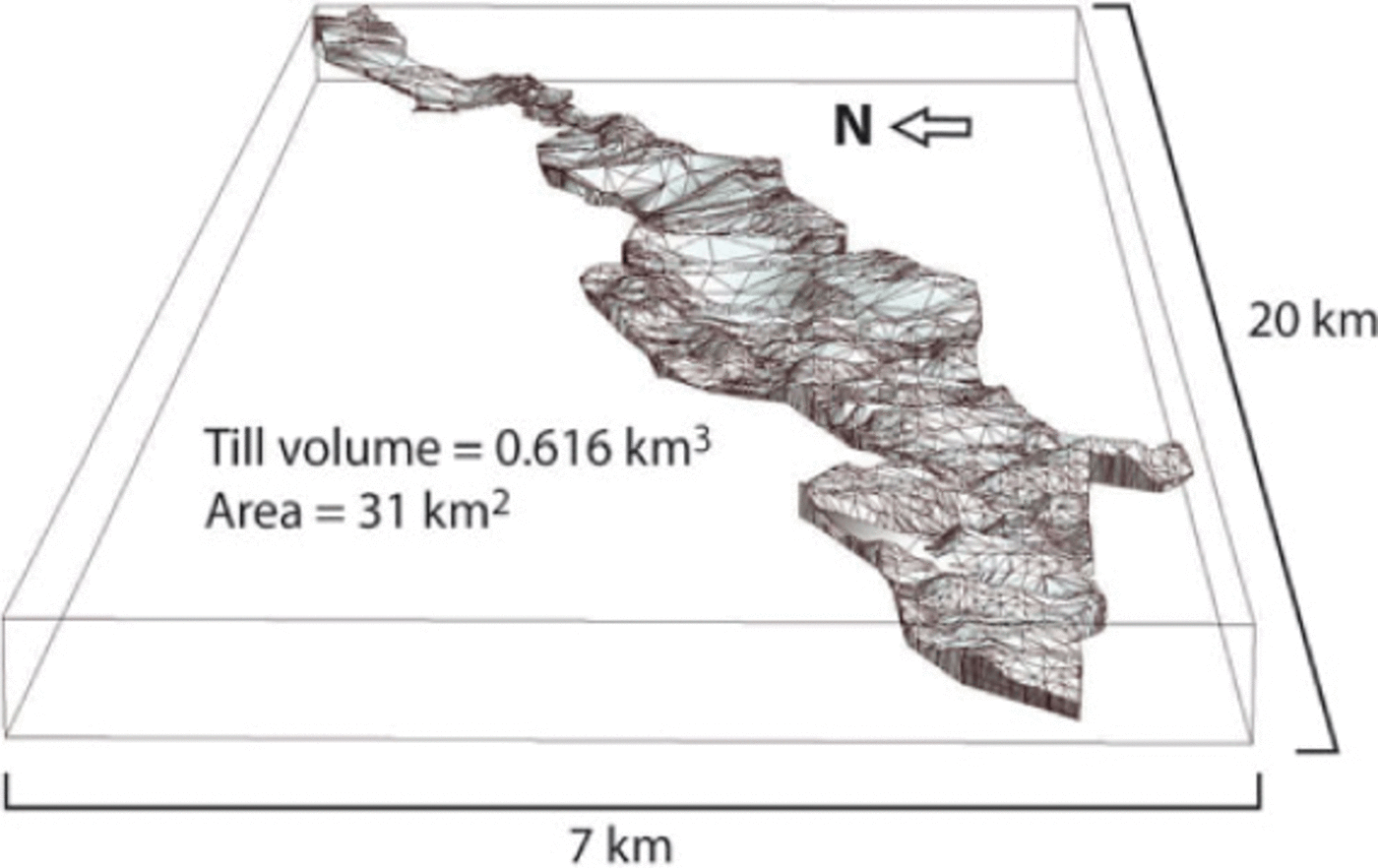
Fig. 11. Till package overlying buried glaciofluvial deposits. This till package is likely to be wholly a product of the last (Late Devensian) glacial cycle.
Glaciofluvial, glaciodeltaic and glaciolacustrine deposits are widespread alongside drainage pathways in the Clyde basin where they reach up to 20 m thickness in places (Fig. 9). Collectively, these deposits represent 11% of the total sediment volume in the basin. The raised marine deposits in the lower Clyde basin provide the second largest contribution (13%) to the total basin sediment volume;these sediments exceed 20 m thickness along pre-existing topographic lows.
Sediment mobilization during the last glacial cycle
Using the event stratigraphy (Fig. 7) and the geological modelling results, progress can be made towards a basin- scale reconstruction of sediment mobilization during the last glacial cycle.
Ice-sheet advance (Fig. 7a)
It has been theorized that ice-sheet advance is a key phase of till deposition (Reference BoultonBoulton, 1996). The preservation of sediments and bedforms interpreted to have begun formation during, or following, this initial stage of the glacial cycle (ribbed moraine and flow set 1 drumlins) does indeed suggest that a significant volume of till had been deposited during the ice-sheet advance phase. Sediment within drumlins is often found to pre-date the drumlin-forming event (Reference Knight and McCabeKnight and McCabe, 1997;Reference Stokes, Spagnolo and ClarkStokes and others, 2011). If this is also true for the Clyde basin drumlins, it supports a case for an early phase of till deposition. The till package that rests on the buried fluvial deposits (Fig. 11) in the Kelvin Valley is considered to have been deposited during the last glacial cycle (see above). Here 0.62 km3 of till has been deposited over 31 km2, which equates to a uniform net deposition rate through the glacial cycle (~35 ka bp to ~15kaBP) of 0.001 ma-1 (or m3m-2a-1). However, if much of that till package was deposited during advance through the basin (this could have occurred over as little as ~0.5 ka, according to the recent BIIS simulation of Reference HubbardHubbard and others (2009)), which is a prerequisite for drumlins to have formed in those sediments, reconstructed net deposition increases to ~0.04ma-1. These till deposition rates are only slightly higher than those proposed for ice-marginal zones by Reference BoultonBoulton (1996) and are of a similar order of magnitude to rates of subglacial till deposition considered by Reference Sugden and JohnSugden and John (1976), but they assume no latter erosion. This assumption can be partially justified here on two accounts: the Clyde basin was subsequently positioned close to, or under, an ice divide during maximum glaciation (Fig. 7b and c; Reference Finlayson, Merritt, Browne, Merritt, McMillan and WhitbreadFinlayson and others, 2010), where minimal erosion would have been expected (Reference BoultonBoulton, 1996); and bedforms interpreted to have formed during early ice-flow stages are preserved. It should be noted that these till accumulation rates cannot be used to estimate bedrock erosion, since a significant fraction is likely to have derived from remobilized sediment (discussed below).
It is clear, however, that till deposition during advance was not uniform across the basin;the ~20m thickness of till described above, in the Kelvin Valley, is not reproduced everywhere (Fig. 9). Preconditioning factors may therefore have influenced till accumulation. It is notable that no marine deposits and few glaciolacustrine deposits are revealed below till in the model. However, conditions prior to ice-sheet build-up indicate that such deposits were likely to have been locally extensive: global sea level was at least 6.6m higher during the Last Interglacial (marine isotope stage (MIS) 5e; Reference Kopp, Simons, Mitrovica, Maloof and OppenheimerKopp and others, 2009) and relative sea level was probably higher during the prior continental-scale ice-sheet deglaciation (MIS 6); ice-dammed lakes are also likely to have accompanied ice-sheet build-up by blocking the river Clyde (Reference PricePrice, 1975). Reworking of these deposits probably formed the bulk of till that accumulated during ice-sheet advance (e.g. Reference O Cofaigh, Evans and HiemstraO Cofaigh and others, 2011);indeed lenses of folded laminated sediments have been observed in till in the Glasgow area (Reference MenziesMenzies, 1981). The presence of the thickest till packages in the vicinity of, or immediately down-ice from, modern marine and glaciolacustrine sediments (Figs 3 and 9) lends support to the idea that similar sediments were previously a key source for till deposited during advance. Where ice-sheet advance was into relatively soft, water-saturated sediments (e.g. glaciomarine, glaciolacustrine or deltaic deposits), deformation probably ensued as plug flow (Reference Leysinger Vieli and GudmundssonLeysinger Vieli and Gudmundsson, 2010). Sediment removal up-glacier, may have been in excess of 20 m, based on the thickness of raised marine deposits presently occupying the Clyde basin. Subsequent deposition of thick till then occurred when glaciotectonic stress (lateral stress + shear stress: Reference Aber, Croot and FentonAber and others, 1989) fell below sediment strength, possibly through sediment dewatering as it moved over more permeable (buried glaciofluvial deposits) material, or as the ice margin passed over, leading to a reduction in glaciotectonic stress. The result is that overall transport distances were relatively short, consistent with the limited down-ice distribution of thick till sequences and the preservation of some sedimentary structures locally within the till. Where ice advanced over stiffer pre-existing till, overriding or mixed flow (Reference Leysinger Vieli and GudmundssonLeysinger Vieli and Gudmundsson, 2010) was more likely, with reduced basal sediment mobilization and reduced accumulation of ‘new’ till. A switch to these conditions would also have taken place in zones previously characterized by plug flow, once the supply of relatively soft sediments became exhausted, otherwise the thick till wedge would have migrated down-glacier with the advancing ice front. Thus, spatial variations in sediment mobilization by deformation were probably governed by the relative stiffness of pre-existing substrate, with implications for the glacier flow mechanism.
A result of geological modelling, and previous strati- graphical work in the Glasgow area (Reference MenziesMenzies, 1981;Reference Browne and McMillanBrowne and McMillan, 1989) is that, with the exception of those restricted locations where buried till packages are identified (Fig. 9), only one main till layer (median thickness 5.6 m) is present in the basin. It is extremely unlikely that the ~7km3 of till forming that layer is wholly a deposit from the last glacial cycle. To generate that volume of till again would require ~3 times the volume of all other sediments presently available in the basin for reworking. Given the topographically confined (by Clyde Plateau Volcanic Formation) northwestern entrance to the basin, which has little or no till cover(Fig. 9), transport of the remaining volume of till into the basin via a continuous deforming bed is not probable. It is more likely thattill from previous glaciations remained in the basin and was, to an extent, reused by the next.
Ice sheet established; ice divide migration (Fig. 7b and c)
Coalescence of Highland and Southern Upland ice masses allowed an ice divide to develop in the vicinity of the Clyde basin. The transition of the Clyde basin, from being positioned down-ice from the equilibrium line, to being positioned close to the ice divide (Fig. 7a and b) meant that overall sediment erosion was limited, since maximum erosion is thought to occur just up-ice of the equilibrium line (Reference BoultonBoulton, 1996). The initial position of the ice divide ~30 km to the west facilitated eastward flow associated with drumlins of flow set 1;these probably formed by local erosion and deposition by a mobile till layer (Reference Boyce and EylesBoyce and Eyles, 1991). It is not possible to quantify the volumes involved; however, the presence of much thinner till, and in places absence of till, at the eastern boundary of the basin (Fig. 9), suggests that overall sediment loss through continuous bed deformation would have been restricted. Furthermore, preservation of both sediments and landforms from early parts of the glacial cycle (Reference Browne and McMillanBrowne and McMillan, 1989;Reference Finlayson, Merritt, Browne, Merritt, McMillan and WhitbreadFinlayson and others, 2010) indicates that basal motion was probably concentrated at or near the ice- sediment interface, limiting large-scale sediment transport by deformation. Subsequent migration of the ice divide to a position over the Clyde basin (Fig. 7c) would have further limited any sediment mobilization.
Eastward ice flow (Fig. 7c) became more established towards the end of this phase, as deglaciation commenced. It is interesting to note that there is no difference in characteristics of the eastward-oriented drumlins between zones of buried glaciofluvial deposits and adjacent areas (Fig. 12). Lengths (L) and elongation ratios (ER) for drumlins overlying buried glaciofluvial deposits (n = 46, median L = 645 m, median ER = 2.6) and drumlins within a 2 km zone beyond the margin of the buried glaciofluvial deposits (n = 81, median L = 660, median ER = 2.9) were statistically indistinguishable (Mann-Whitney: z =0.9, p =0.37 for L; z =0.91, p = 0.36 for ER). Drumlin elongation has been suggested to be a proxy for relative basal ice-flow velocity (Reference Stokes and ClarkStokes and Clark, 2001), while basal motion is linked to subglacial water pressure (Reference PatersonPaterson, 1994). It is therefore likely that enhanced drainage through the buried glaciofluvial gravelly sands (which were at the land surface prior to advance), was precluded by the thick till preferentially deposited on top (Fig. 10). This would have equalized effective pressures between zones underlain by buried fluvial deposits and adjacent areas. Thus, by focusing thick till sequences over more permeable substrates during advance, the ice sheet may have essentially regulated its basal conditions, facilitating smoother overall basal motion.

Fig. 12. Drumlinized terrain in north Glasgow. The zone of buried glaciofluvial deposits revealed by the geological model is delimited by the white dashed line. The extent of streamlining is statistically indistinguishable inside and outside this zone of buried glaciofluvial deposits. Hill-shaded digital surface model built from Internet Technologies NEXTMap Britain topographic data.
Ice-cap uncoupling and deglaciation (Fig. 7d and e)
During and following ice-cap uncoupling, glacier flow in the lower Clyde basin was generally towards the southeast, documented by flow set 4. The drumlins formed during this stage are some of the best preserved in the basin and indicate that till erosion and down-ice deposition were locally occurring at this time. However, for reasons outlined above, it is unlikely that significant volumes of till were lost from the basin by continuous deformation.
The combined volume of the glaciofluvial, glaciolacus- trine and glaciodeltaic deposits is 1.08 km3, giving an approximation for the minimum volume of sediment remobilized (predominantly by sub-/proglacial fluvial processes) during ice-sheet withdrawal. The approximation is a minimum since drainage was diverted eastward (via successive overflow cols towards the Firth of Forth) for a period following ice-cap decoupling, which would have resulted in some unaccounted sediment loss, and sediment loss to the Firth of Clyde is not included. These sediments make up 11% of the total sediment volume in the basin. The duration over which they were deposited only represents the final 2.5% of the last glacial cycle in the area (~0.5 ka maximum, based on a synthesis of dates and ice-margin retreat isochrones published in Clark and others (in press)), indicating that transport and deposition by glacial meltwater formed a disproportionately high contribution to the basin sediment budget as the ice margin retreated through the basin. This supports the suggestion by Reference Alley, Cuffey, Evenson, Strasser, Lawson and LarsonAlley and others (1997) that high sediment transport capacities are achieved by subglacial streams in ice-marginal areas, where surface water accessing the bed can promote high water discharges forced by steep head gradients.
Wider Implications
The work presented here has attempted to characterize the volume and style of sediment mobilization through the last glacial cycle in the Clyde basin. During that time the basin was occupied by an advancing outlet glacier; it was then positioned under a migrating ice divide, and then once more occupied by an outlet glacier during ice-sheet uncoupling and deglaciation. The data presented here may therefore provide insight into sediment movement in such environments. Although the Clyde basin may have temporarily been located close to the onset zone of fast glacier flow, it was not occupied by an ice stream and is thus not representative of ice-streaming conditions.
Ice-margin advance is shown to have been associated with highly variable spatial and temporal patterns of sediment mobilization. Where ice advanced into relatively soft glaciomarine and glaciolacustrine deposits, sediment fluxes in the marginal area were high. Only rare opportunities exist to study modern glaciers advancing into soft sediments, but, where observed, high fluxes are apparent. For example, the advance of Taku Glacier, Alaska, USA, which is a good modern analogue for Clyde Glacier in its advance stage, has displaced >100 m of marine sediment from its bed since 1890 (Reference Nolan, Motyka, Echelmeyer and TrabantNolan and others, 1995). In the case of Clyde Glacier, this high rate of sediment mobilization and redeposition was spatially, and probably temporally, restricted. Reduced basal sediment mobilization took place where relatively soft sediments were absent, or following the exhaustion of soft sediments.
The preferential deposition of thick till over glaciofluvial sediment appears to have acted as a seal, negating the increased drainage capacity of the latter. This suggests that glacier advance and till deposition can alter basal conditions by promoting lower effective pressures. As a result, motion is focused at the ice-till interface, and ice infiltration into the bed by regelation inhibited (Reference IversonIverson, 2010). In the case of the Clyde basin, this would have favoured preservation of both sediments (Reference Browne and McMillanBrowne and McMillan, 1989) and bedforms (Reference Finlayson, Merritt, Browne, Merritt, McMillan and WhitbreadFinlayson and others, 2010) that were produced early in the glacial cycle. However, localized erosion and deposition by a relatively shallow layer of flowing sediment (Reference Boyce and EylesBoyce and Eyles, 1991; Reference ClarkClark, 2010) must also have occurred in order to carve bedforms during subsequent phases of the glacial cycle.
The Clyde basin is a relatively small area at the ice-sheet scale. Thus, it highlights the spatially variable nature of some bed properties over small areas. The highly variable modelled till thickness (Fig. 9) (mean 7.7m, standard deviation 7.0 m) demonstrates that uniform till sheets (Reference AlleyAlley, 1991) do not necessarily occur in all lowland areas.
A considerable volume of sediment in the Clyde basin was remobilized by glacial meltwater during ice-sheet withdrawal, highlighting its role as a geomorphological agent. While the subglacial imprint (e.g. drumlins) often produces the most striking landscape features, ice-margin advance and deglaciation are suggested, in the case of the Clyde basin, to have been key (possibly more important) factors influencing the overall sediment budget during the glacial cycle.
Acknowledgements
I thank David Sugden and Tom Bradwell, and numerous British Geological Survey (BGS) colleagues, for useful discussions; and David, Tom and Clive Auton for their comments on an earlier draft of the manuscript. Helpful comments from two reviewers and the scientific editor, Neil Glasser, improved the paper. This work was carried out as part of the Clyde Urban Super Project (CUSP), a multidisciplinary project that provides geoscience information for urban renewal projects in and around Glasgow. Published with the permission of the Executive Director of the UK Natural Environment Research Council.


